

Georgia map
Cartersville map
About 25,082 people live here (Census Bureau, 2024 estimate). The sheet's index lists 300 streets; Joe Frank Harris Parkway Southeast, West Avenue and Etowah Drive cross the most grid squares. Things to do inside the boundary: Bartow History Museum, Booth Western Art Museum and Rose Lawn Museum.
Open the map (PDF, US Letter)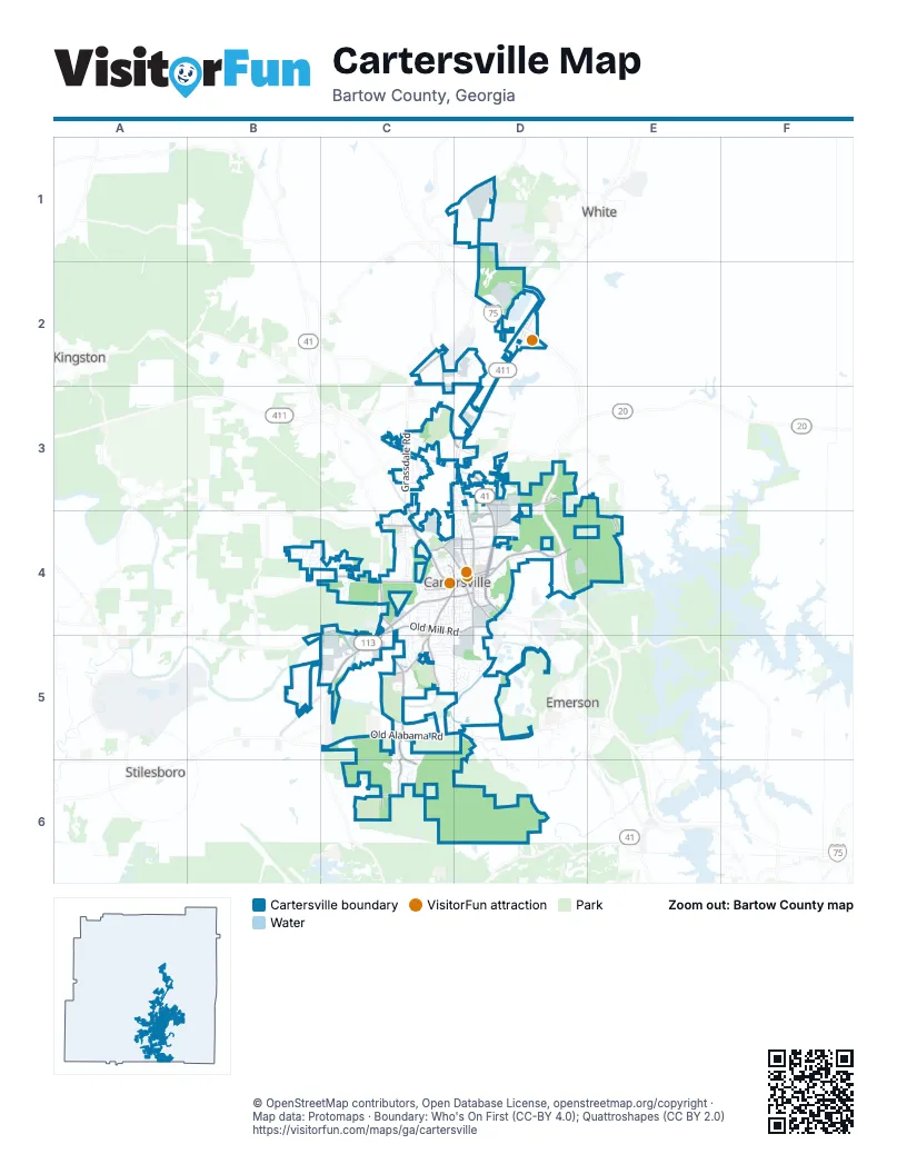
Street index of Cartersville
Each street on the sheet and the grid squares it crosses.
- Joe Frank Harris Parkway SoutheastC3, D3, D4
- West AvenueC4, D4, C5
- Old Alabama RoadC5, D5
- East Main StreetD4
- North Tennessee StreetD3, D4
- Etowah DriveC4, D4, C5
- Rockmart HighwayB5
- West Main StreetC4, D4
- North Morningside DriveD4
- Cassville RoadC4
- Burnt Hickory RoadC4
- North Erwin StreetC4, D4
- Grassdale RoadC3
- West Cherokee AvenueC4, D4
- Euharlee Road SouthwestC4, C5
- Mission Road SouthwestC4
- South Tennessee StreetD4
- Dixie AvenueD4
- East Church StreetD4
- Mission Road SoutheastC4
- North Bartow StreetC4, D4
- West Church StreetC4, D4
- Cassville Road SoutheastC3, C4
- Main StreetD5
- Dallas Highway SoutheastC5
- Douthit Ferry RoadC4, C5
- Old Mill RoadC4, D4, C5
- Belmount DriveC5, C6
- Cartergrove BoulevardC5, C6
- Peeples Valley Road NortheastC2, C3, D3
- Center Road SoutheastD3, D4
- South Erwin StreetD4, D5
- Martin Luther King DriveD4
- East Felton RoadD3
- North Gilmer StreetD4
- Pine Grove RoadC5
- Rowland Springs RoadD3, D4
- Old Grassdale Road NortheastC2
- Sugar Valley RoadC4
- Porter StreetC4, D4
- Indian Mound Road SoutheastC5
- Gentilly BoulevardD4
- Walnut Grove Road SoutheastC5
- South Dixie AvenueD4
- Mockingbird DriveD4
- Roving RoadD3
- Zena DriveD3
- State Highway 20 Spur SoutheastE4
- Cass White RoadD1
- East Cherokee AvenueD4
- Justice Robert Benham DriveD4
- Cass White Road NorthwestD1
- Cline Smith Road NortheastD3
- Center RoadD4
- East Iron Belt Road SoutheastC3
- Paga Mine Road SoutheastD5
- Mission Hills Drive SouthwestB4, C4
- Waterford DriveD5
- Industrial Park Road NortheastC2, D2
- Jones Mill RoadC3, C4, D4
- Mercer LaneC4
- Twelve Oaks Drive SoutheastC4
- Old River Road SoutheastD4, E4
- Pioneer TrailD4
- Parkview DriveC5
- Donn DriveC4
- Douglas StreetD4
- South Bartow StreetD4
- Busch Drive NortheastD2
- Terrell DriveC4
- Riverside Drive SouthwestC5
- Arrowhead DriveC4, C5
- Mayflower StreetC4
- Davis DriveD3, D4
- Brookwood DriveC3
- Brown Farm Road SouthwestB5
- Ann CircleD3, D4
- Walnut DriveC4, C5
- Main Street Market PlaceD4
- Heartwood Drive SouthwestB4
- Country Club DriveC3
- Lee StreetC4
- Dogwood DriveC3
- Summit Ridge Drive SoutheastC6
- Maple DriveC4, C5
- Cotton BendC3
- Goodyear AvenueC4
- Wingfoot TrailC4
- Luckie StreetC4, D4
- Allison CircleC4
- Glenn Cove DriveC5, D5
- Grogan Road NortheastC1, D1
- Thornwood Drive NortheastC3
- River DriveD4, D5
- Stonewall StreetD4
- Quail RunC3, D3
- Meadow LaneC3
- Georgia BoulevardD4
- Summit StreetD4
- Galway DriveD5
- Stately Oaks DriveC4
- Jones StreetC4
- Woodcrest Drive SouthwestC4
- Skyview CircleC3
- River Shoals DriveC5, D5
- Benham CircleC3
- Woodland DriveC4
- Briar Patch LaneC5
- Parmenter StreetC4
- Magnolia DriveC3
- Cook StreetD4
- Leake StreetC4, D4
- Tellus DriveD2
- Wansley Drive SoutheastD3, D4
- Old Grassdale RoadD1, D2
- Lakewood CourtC5, C6
- Crestwood RoadD4
- Westchester DriveD5
- Opal StreetD4
- Roosevelt StreetD4
- Curtis Court SouthwestC5
- Parr Wade Road SoutheastC3, C4
- Wellington DriveC5
- Industrial DriveD4
- Courtyard LaneC4
- Great Valley ParkwayD1
- Ridgeview DriveC4
- Johnson StreetD4
- Busch DriveD2
- Grove Pointe WayC6
- Friction Drive SouthwestB5
- Oak Hill CircleC3
- Carrington DriveC5
- Aubrey StreetC4
- Clearview DriveD3
- Larkwood CircleC4, D4
- Bob White TrailC4, C5
- Komatsu DriveD4
- White Oak Drive SoutheastD4
- Liberty DriveD4
- Fite StreetC4
- Lake Haven DriveC5
- Ridgewood DriveC5
- Oakdale DriveC3
- Savoy LaneD3
- Boatner AvenueC4, D4
- Thoroughbred LaneD4
- Ponders RoadD3
- Mayflower CircleC4
- Greenway LaneC4
- Mary StreetD4
- Hastings DriveD5
- Brookshire DriveD4
- Governors CourtC3
- Kerry StreetD2
- Autumn Canyon PathD3, D4
- Pointe North DriveC3, D3
- Bates RoadD6
- Fairview StreetD4
- Town and Country DriveC5
- Wofford StreetC4
- Tatum Ridge Road SouthwestC4
- South Morningside DriveD4
- Pembroke LaneC5, D5
- Nelson StreetD4
- South AvenueD4
- Greenbriar AvenueC3, D3
- Spring StreetC3, D3
- Milner Road SoutheastC5
- Henderson DriveC4
- Dent Road NortheastD3
- Green Acre LaneC3
- Ohio StreetC4
- Highland LaneD3, D4
- Mimosa LaneD4
- Jackson StreetC4
- North AvenueC4, D4
- Akron StreetC4
- Lennox Park AvenueD4
- Massell DriveC3
- McEver StreetD4
- Blackfoot Trail SouthwestC4
- Litchfield StreetC4
- Courrant StreetD4
- West Carter StreetC4, D4
- Ridgemount WayC6
- Knight StreetC4
- Wildwood DriveD3, D4
- Pine Ridge Drive SouthwestC4
- Townsley DriveD4
- Charley Harper DriveC4
- Stadelman CourtC4
- Bruce StreetD4
- Grove Park RoadC5
- Enon Ridge RoadD6
- Postelle StreetD4
- Road 1 South SouthwestB4
- Granger DriveC4
- Ridge Row DriveD4
- Carter Road SouthwestC4
- Ford StreetD4
- Mitchell AvenueC4
- Bangor StreetD4
- Plymouth DriveC4
- Tabernacle StreetC4
- Howard StreetD4
- Peachtree StreetD4
- Collins DriveD3
- Weaver StreetC4, D4
- Saint Francis PlaceC4
- Topridge DriveC4
- Aubrey Lake RoadD2
- Forrest AvenueD4
- Mc Canless StreetD4
- Buford StreetD4
- Pine StreetC4
- Sunset CircleD4
- Miles DriveC4
- Pathfinder StreetC4
- Hepworth LaneD5
- Linsey DriveD4
- Saddle Brook DriveD4
- Tumlin StreetC4, D4
- Mossy Rock Lane SouthwestB4
- Aspen LaneC5, C6
- Forrest Hill DriveD4
- North Museum DriveD4
- Maybelle StreetD4
- Pyron Court NortheastD2
- Hannon WayC3, C4
- All Metals Drive SouthwestC5
- Clubview DriveC3
- Wesley Trace SoutheastC3, C4
- Quality DriveC4
- Natchi Trail SoutheastC5
- Alpine DriveC5
- Little Valley RoadC3
- Corbitt DriveD5
- Floyd Road SouthwestC4
- Greystone WayC6
- William Drive NortheastD2
- Rock Ridge CourtC6
- East Carter StreetD4
- Brook DriveD4
- Oxford DriveD5
- Buckingham CourtD5
- Westview Drive NortheastD3
- Commerce DriveC4
- Mill Creek Drive SoutheastC3
- Mountain Chase DriveD3
- Estate Drive SouthwestB4
- Greywood LaneC6
- Remington Drive SouthwestB4
- Apache TrailC4
- Charles StreetC4
- Sterling CourtD5
- Stonehaven CircleD3
- Stratford LaneC5
- Hickory LaneD3
- Mull StreetC4
- Forrest LaneD4
- Felton Walk BoulevardD3
- Valley View DriveC4
- Swisher DriveD5
- Park CircleD4
- Herring StreetC4
- Indian Trail SoutheastC5
- Bridgestone WayC5, C6
- Hill StreetC4
- Valley DriveC4
- Walker StreetC4
- Hilltop DriveC4
- Vigilant StreetC4
- Lewis DriveD4
- Clover LaneD4
- Penfield DriveC4
- Robinson Loop SouthwestC4
- Greencliff WayC6
- Freeman StreetC4, D4
- Latimer RoadD3
- Clearwater StreetC4
- Forest Hill Drive SouthwestB4
- Pine Forest RoadD3, D4
- Green StreetC4
- Tanglewood DriveC5
- Plantation Ridge DriveC6
- Ashwood DriveC5
- Redcomb DriveC4
- Calloway LaneC4
- Cedar LaneC4
- Autumn Wood DriveC6
- Marketplace BoulevardD3
- Ellis Road NortheastD2
- Roving Hills CircleD3
- Woodview DriveC4
- Cresent Drive SouthwestB4
- Elizabeth StreetD4
- Liberty Square Drive NortheastD3
- Wayside Drive SouthwestC4
- High Point Drive SouthwestB4
Things to do on the Cartersville map
Places on the map
- 84 Lumber
- Advance Auto Parts
- Agan's Bakery
- AGC Pediatrics
- Ameris Bancorp
- Ameris Bank
- Arby's
- Atco Baptist Church
- Aubrey Street Pool
- AutoZone
- Bank OZK
- Bartow Animal Hospital
- Bartow County Courthouse
- Bartow County Jail
- Bee Mountain
- Cartersville High School
- Cartersville Middle School
- Cartersville Soccer Complex
- Cartersville Sports Complex
- Conner Lake
- Deerfield Park
- Dellinger Park
- East Loop
- Excel Christian Academy
- Historic Downtown
- Main Street Shopping Center
- Matthew Hill Park
- Oak Hill Cemetery
- Old Mill Park
- Pine Mountain
- Pittman Lake
- Ponders Mountain
- Reservoir Hill
- Sam Smith Park
- The Cartersville Country Club
- TrinityRail Autorack Maintenance
- West End Commons
- West Loop
- Woodland Hills Golf Club
Next to Cartersville
- Emerson
- Kingston
- Stilesboro
- White
© OpenStreetMap contributors, Open Database License, openstreetmap.org/copyright · Map data: Protomaps · Boundary: Who's On First (CC-BY 4.0); Quattroshapes (CC BY 2.0)















