

Georgia map
Bartow County map
About 117,508 people live here (Census Bureau, 2024 estimate). The sheet's index lists 300 streets; Joe Frank Harris Parkway Southeast, Old Alabama Road and Joe Frank Harris Parkway Northwest cross the most grid squares. Things to do inside the boundary: Bartow History Museum, Booth Western Art Museum and Etowah Indian Mounds State Historic Site.
Open the map (PDF, US Letter)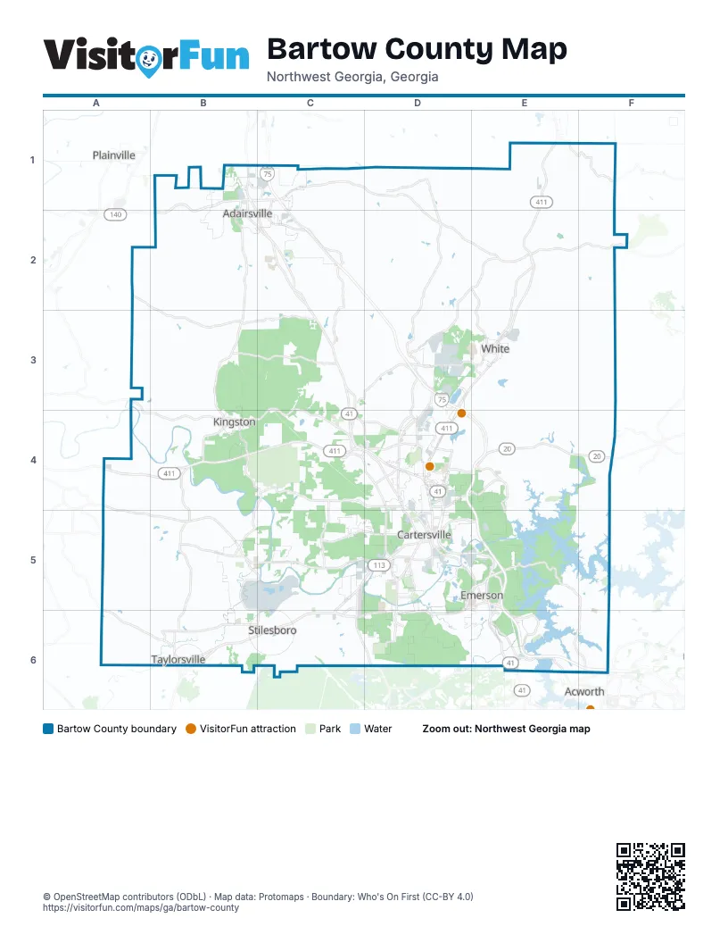
Maps inside Bartow County
1 map inside, from the street map of Bartow County down.
Street index of Bartow County
Each street on the sheet and the grid squares it crosses.
- Joe Frank Harris Parkway SoutheastC3, C4, D4, D5, E5, E6
- Old Alabama RoadD5, A6, B6, C6, D6
- Rockmart HighwayC5, B6, C6
- Adairsville HighwayB1, C1, B2
- Canton HighwayD4, E4, F4
- Joe Frank Harris Parkway NorthwestB1, B2, C2, C3, C4
- Joe Frank Harris ParkwayB1, C3, E5, E6
- Red Top Mountain Road SoutheastE5
- West AvenueC5, D5
- Glade Road SoutheastE5, F5, E6, F6
- East Main StreetD5, E5
- North Tennessee StreetD4, D5
- Etowah DriveD5
- Red Top Mountain RoadD5, E5
- West Main StreetB4, D5
- Old Dixie HighwayB1
- North Morningside DriveD5
- Cobb ParkwayE6
- Cartersville Highway SoutheastA4
- Glade RoadF6
- Allatoona GatewayF6
- Cherokee StreetF6
- Allatoona GtwyF6
- Adairsville Road NortheastB2
- Kingston HighwayA3, C3, A4, B4, C4
- Hardin Bridge Road SouthwestB4, C4, B5
- Hall Station Road NorthwestB1, B2, B3
- State Route 140C1, D1, D2, E2, F2
- Macedonia RoadB4, F4, B5, E5, F5
- Euharlee Road SouthwestB5, C5, D5
- Mission Road SouthwestC4, C5, D5
- Euharlee RoadA4, A5, B5
- Burnt Hickory RoadC4, D4, D5
- Cass White Road NorthwestC3, D3
- Old Allatoona Road SoutheastE5, E6
- Dallas Highway SoutheastC5, C6, D6
- Cassville Road NorthwestC3, C4
- Folsom Road SoutheastC1, D1
- Main StreetB4, D5, E5, B6
- Cassville RoadD4, D5
- Grassdale RoadD4
- Reynolds Bridge RoadB4
- Burnt Hickory ConnectorC4
- Cassville Road SoutheastD4
- Cassville Road SouthwestC4, D4
- Hall Station RoadB3, B4
- Grassdale Road NorthwestD4
- Old State Highway 113B6
- North Erwin StreetD5
- West Cherokee AvenueD5
- Howard StreetB4, D5
- South Tennessee StreetD5
- Dixie AvenueD5
- Church StreetB2, B4, B6
- East Church StreetD5
- Mission Road SoutheastD5
- North Bartow StreetD5
- West Church StreetD5
- Red Top ConnectorE5
- West Howard StreetB4
- Boyd Morris DriveC4
- North Main StreetE6
- Cartersville HighwayD6
- Waleska HighwayF2
- Kingston Highway SoutheastA3
- Cassville Pine Log Road NortheastD2, E2, D3
- Sugar Valley Road SouthwestC4, D4
- Old Tennessee Highway NortheastE2, E3
- Old Highway 41 NorthwestC2, C3
- Taylorsville Macedonia Road SouthwestB5, B6
- Peeples Valley Road NortheastD3, D4
- Spring Place RoadD1, D2, D3
- Iron Hill RoadA5, A6, B6
- Covered Bridge Road SouthwestB5, C5, B6, C6
- Griffin Road NorthwestB3, C3
- Richards RoadE2, E3
- Spring Place Road NortheastD2, D3
- State Highway 20 Spur SoutheastE4, E5
- Old Mill RoadD1, D5
- Pleasant Valley RoadC2, C3
- CCC Road NorthwestB3, C3
- Salacoa RoadE1, F1
- Center Road SoutheastD4, E4
- Douthit Ferry RoadD5, D6
- Cliff Nelson RoadB5
- Cass White RoadD3, E3
- Adairsville Pleasant Valley RoadC2
- Barnsley Gardens Road NorthwestB3
- Old Grassdale Road NortheastD3, D4
- Old Highway 293E6
- Railroad StreetB1, B2, E3, B4, D5
- Martin Luther King DriveC2, D5
- Busch Drive NortheastD3
- East Pleasant Valley Road NorthwestC2, D2
- LakePoint ParkwayE5, E6
- Sandtown Road SoutheastE6
- North Main Street SoutheastE6
- Mac Johnson Road NorthwestC4, D4
- Road 2 South SouthwestC4, C5
- Belmount DriveD6
- Cartergrove BoulevardD6
- Barnsley Garden RoadA2, B2, B3
- Rudy York Road NorthwestC4, D4
- Cline Smith Road NortheastD4
- Indian Mound Road SoutheastD5
- Industrial ParkwayB1, C1
- Folsom Glade RoadD1
- Bishop Road NorthwestD4
- East Felton RoadD4
- South Erwin StreetD5
- Adairsville Pleasant Valley Road NorthwestC2
- Walnut Grove Road SoutheastD5
- Harrison RoadC5
- Old Grassdale RoadD3
- North Gilmer StreetD5
- Horse Show Road NorthwestC2
- Old Alabama Road SoutheastD5, E5
- Pine Grove RoadD5
- Poplar Springs RoadC1, C2
- Rowland Springs RoadD4, D5
- Gilreath Road NorthwestD4
- Sugar Valley RoadD4
- Richards Road NortheastE3
- Euharlee StreetB6
- East Iron Belt Road SoutheastD4
- Pleasant Valley Road NorthwestC3
- Porter StreetD5
- Roving RoadD4
- Gaston Westbrook AvenueE5
- Old Alabama Road SouthwestC5, C6
- Stars WayE6
- Barnsley Gardens RoadB3
- Main Street NorthB1, B2
- 41st StreetB2, C2
- West Iron Belt RoadD4
- Gentilly BoulevardD4
- South Dixie AvenueD5
- Taylorsville RoadB6
- Mockingbird DriveD4
- Main Street SouthB2
- Folsom Glade Road NorthwestD1
- Zena DriveD4
- Summer StreetB2, C2
- East Cherokee AvenueD5
- King StreetB1, B2
- Justice Robert Benham DriveD5
- Blackacre Trail SoutheastE6
- Georgia North CircleC1
- International ParkwayB1
- West Railroad Street NorthwestB4
- Center RoadD4
- Chulio RoadA4
- Black Acre TrailE6
- East Valley RoadE2, F2
- Rock Fence Road NorthwestB2, B3
- Johnson Mountain RoadE1, F1, E2
- Mount Pleasant RoadE1, D2, E2
- Tom Jones RoadA3, B3
- Stamp Creek Road NortheastE3, F3, F4
- Connesena RoadA3, B3
- Wilderness Camp Road SoutheastE4, E5
- Towe Chapel Road NorthwestD1, D2
- Wayside RoadA2, B2, A3, D4
- Holly Springs Road NortheastE3, E4
- Falling Springs RoadE1, E2
- Cedar Creek RoadD2, C3, D3
- White RoadB2, C2
- John Kay RoadA5
- Nalley RoadD1, E1, D2
- Mostellers Mill RoadC1, C2
- Old River Road SoutheastD5, E5
- Adcock Road NorthwestD2
- Oak StreetB2, E2, E3, D5, E6
- Bozeman Road NorthwestD1, D2
- Big Pond Road SouthwestB5, B6
- Old Rome RoadB4
- Paga Mine Road SoutheastD5, D6
- Law Road NorthwestC3
- Calico Valley RoadE1, E2
- Mullinix RoadB3
- Big Oak Tree Road NorthwestB2
- Taff RoadC6
- Dry Creek Road NorthwestB2
- Sewell Road SouthwestA6, B6
- Clear Creek RoadC2, C3
- Martin Road SouthwestC4
- Jarrett Loop NorthwestB2, C2
- Stamp Creek RoadE3
- Worthington RoadB4, B5
- Boyd Mountain Road NorthwestB2
- Kirk Road NorthwestD2
- Crowe Springs Spur NorthwestD2, D3
- Satcher RoadA4, A5
- Old Cassville White Road NorthwestD3
- Snow Springs Road NorthwestB2
- Popham RoadB5, B6
- Ward Mountain RoadB2, B3
- Barnsley Church RoadA3, B3
- Jones Mill RoadD4, D5
- Lucas Road SouthwestC6
- Bells Ferry RoadE3, E4
- Stiles RoadC5
- Miller Farm RoadA5, B5
- Alford Road SoutheastA4
- Boyd Mountain RoadB2
- Ridge Cross RoadA5, A6
- Grover RoadB2
- Arnold RoadE1, C4
- Puckett Road SoutheastE5, D6, E6
- Bartow Carver Road SoutheastE5, F5
- Shinall Gaines Road NorthwestD3
- Crowe Springs Road NorthwestD2, D3
- Road 3 South SouthwestC4, C5
- Brown Farm Road SouthwestC5
- Knucklesville RoadE2
- Allatoona Dam RoadE5
- Hamilton Crossing Road NorthwestC4
- Jones Slough RoadB5
- Perkins Mountain RoadB2, B3
- Mathews Road NorthwestC2, D2
- Twin Bridges RoadB1, B2
- Road 1 South SouthwestC4, C5
- Stoners Road NorthwestC2
- Long Road NortheastE1, E2
- Norton RoadA3, B3
- Carol Slough RoadB4, B5
- Mission Hills Drive SouthwestC5
- Green Ridge Road SoutheastD6, E6
- Brown Loop NorthwestD3
- Bates Road SoutheastD6
- Horseshoe LoopB2, B3
- Bowen Road NortheastD2, E2
- Floyd Creek Church RoadB6, C6
- Mckaskey Creek Road SoutheastE4
- Vulcan Quarry RoadE4
- Massingale RoadB3, B4
- Veach LoopB2
- Simpson Road NortheastD3
- Euharlee Five Forks RoadB5
- Pine Ridge Road NorthwestD2
- Great Valley ParkwayD3
- Wade Road SouthwestA5, B5
- Industrial Park Road NortheastD4
- Fire Tower Road NorthwestC3, C4
- Perry RoadD1, E1
- Aubrey RoadE3
- Bells Ferry Road NortheastE3
- Bartow Beach Road SoutheastE5
- Gaddis Road NorthwestC3, C4
- Oak Grove Church RoadB1
- Mansfield Road NortheastD2, D3
- Shotgun Road NorthwestC3, D3
- Crowe Springs RoadD3
- Gaines Road NorthwestD3
- Amberidge Drive SoutheastD4
- Greatwood DriveE4
- Bunch Mountain Road NorthwestC2
- Cedar Creek Road NorthwestD2
- New Hope Church Road SoutheastF6
- Ore Mine RoadA5, B5
- Kings Camp Road SoutheastE5, E6, F6
- Hendricks RoadD3, E3
- Brown Loop Spur NorthwestD3
- Waterford DriveD5
- Two Gun Bailey RoadB6
- Farr CircleF2
- West Oak GroveB1
- Waterside Drive SoutheastE5
- Timberwood Road NorthwestD2
- Powell RoadD1, D2
- Macedonia Camp RoadF4, E5, F5
- Rowland Springs Road SoutheastE4
- Oak Grove RoadB5
- Cowan DriveC4
- Holcomb Road NorthwestC2, D2
- Smith RoadD4, A5, A6
- Vaughn Dairy RoadE2
- Somerset LaneE5
- Old Wade Road NorthwestA3
- Snow Springs RoadB2
- Bill Nelson RoadB5
- Davis DriveB1, D4, B6
- Folsom Road NorthwestD1
- Old Hall Station RoadB3
- Summit Ridge Drive SoutheastC6, D6
- Lucas LaneC6
- Groovers Landing Road SoutheastE6
- Simpson Circle NortheastE4
- River Walk ParkwayC5
- Buttrum RoadB2
- Boss RoadB4
- Mitchell Road NorthwestC1, C2
- Milam Bridge Road SouthwestC5
- Biddy Road NorthwestB2
- Manning Mill Road NorthwestC2
- Iron Hill CoveE5
- Jacobs Road SoutheastF6
- Sparks RoadB3
- Jackson Road SouthwestB5
- Williams RoadB5
Things to do on the Bartow County map
Places on the map
- Adairsville
- Adairsville High School
- Adairsville Quarry
- Allatoona Landing Marine Resort Campground
- Ash Dump
- Aubrey Lake
- Bartow County Landfill
- Bartow Quarry
- Browns Lake
- Cartersville
- Cartersville Airport
- Cartersville Health Park
- Cass High School
- Cherokee Retreat Center
- Clear Lake
- Coal Storage
- Creekside Farms
- Dellinger Park
- Downtown Adairsville
- Drummond Swamp
- East Loop
- Emerson
- Euharlee
- Hamilton Crossing Park
- Highland Pointe
- Historic Downtown
- Kingston
- Lake Margarete
- LakePoint Sports
- Little Lake
- Main Street Shopping Center
- New Riverside Ochre Quarry
- Sam Smith Park
- Stilesboro
- Taylorsville
- The Cartersville Country Club
- Vaughn Lake
- West Loop
- White
Next to Bartow County
- Acworth map
- Plainville
© OpenStreetMap contributors, Open Database License, openstreetmap.org/copyright · Map data: Protomaps · Boundary: Who's On First (CC-BY 4.0); Quattroshapes (CC BY 2.0)















