

Georgia map
DeKalb County map
About 770,307 people live here (Census Bureau, 2024 estimate). The sheet's index lists 148 streets; Atlanta Bypass / The Perimeter, North Decatur Road and East Ponce de Leon Avenue cross the most grid squares. Things to do inside the boundary: Decatur, Fernbank Museum of Natural History and Stone Mountain Park.
Open the map (PDF, US Letter)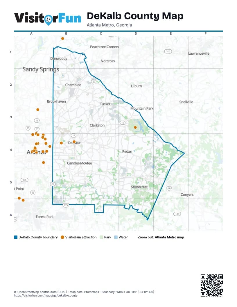
Street index of DeKalb County
Each street on the sheet and the grid squares it crosses.
- Ashford Dunwoody Road NortheastB1, B2
- Chamblee Dunwoody RoadB1
- Chamblee Dunwoody WayB1
- Dunwoody Club DriveB1
- Mount Vernon HighwayB1
- Mount Vernon RoadB1
- North Peachtree RoadB1, B2
- North Shallowford RoadB1, B2
- Perimeter Center Parkway NortheastB1, B2
- Perimeter Center WestB1
- Roberts DriveB1
- Tilly Mill RoadB1, B2
- Peachtree Industrial BoulevardC1, B2
- Winters Chapel RoadC1, C2
- Atlanta Bypass / The PerimeterB2, C2, C3, C4, B5, C5
- Buford HighwayB2, C2, B3
- Carver DriveB2
- Chamblee Tucker RoadB2, C2, C3
- Clairmont RoadB2, B3, B4
- Clairmont Road NortheastB2, B3
- Cotillion DriveB2
- Flowers RoadB2
- Hammond Drive NortheastB2
- I-85 Access RoadB2, C2, B3
- Johnson Ferry Road NortheastB2
- Lake Hearn Drive NortheastB2
- Motors Industrial WayB2
- Northeast ExpresswayB2, C2, B3
- Peachtree BoulevardB2
- Peachtree Road NortheastB2, B3
- Perimeter Summit ParkwayB2
- Savoy DriveB2
- South Johnson Ferry Road NortheastB2
- Button Gwinnett Drive NorthwestC2
- Dawson BoulevardC2
- Interstate Highway 85C2
- Lawrenceville HighwayC2, B3, C3
- Mountain Industrial BoulevardC2, C3
- Northcrest RoadC2
- Oakcliff ExtendedC2
- Oakcliff RoadC2
- Pleasantdale RoadC2
- Tucker Norcross RoadC2
- Briarcliff Road NortheastB3, C3, B4
- Church StreetB3, B4
- Clifton RoadB3, B4
- Clifton Road NortheastB3, B4
- Dekalb Industrial WayB3, B4
- East Roxboro Road NortheastB3
- I 85 Access RoadB3
- Lavista RoadB3, C3
- Lavista Road NortheastB3
- North Decatur RoadB3, C3, B4, C4
- North Druid Hills RoadB3, C3
- North Druid Hills Road NortheastB3
- Peachtree RoadB3
- Roxboro RoadB3
- Scott BoulevardB3, B4
- Stone Mountain FreewayB3, C3, D3
- East Ponce de Leon AvenueC3, D3, B4, C4
- Frazier RoadC3
- Hugh Howell RoadC3, D3
- Memorial DriveC3, D3, B4, C4
- North Hairston RoadC3, C4
- Valley Brook RoadC3
- Five Forks Trickum RoadD3
- James B. Rivers Memorial DriveD3
- Lilburn-Stone Mountain RoadD3
- Main StreetD3, D5
- North Stone Mountain Lithonia RoadD3, D4
- Old Stone Mountain RoadD3
- West Mountain StreetD3
- Adair StreetB4
- Atlanta AvenueB4
- Avondale RoadB4
- Candler RoadB4, B5, C5
- Candler Road NortheastB4
- Candler Road SoutheastB4
- Clairemont AvenueB4
- College Avenue NortheastB4
- Commerce DriveB4
- DeKalb Avenue NortheastB4
- East College AvenueB4
- East Lake DriveB4
- East Lake Road NortheastB4
- Glenwood Avenue SoutheastB4
- Glenwood RoadB4, C4
- John Lewis Freedom Parkway NortheastB4
- Memorial Drive SoutheastB4
- Moreland Avenue NortheastB4
- Moreland Avenue SoutheastB4, B5, B6
- North Arcadia AvenueB4
- North Avondale RoadB4, C4
- North Decatur Road;Oxford Road NortheastB4
- Paden CircleB4
- Park PlaceB4
- Park Place NortheastB4
- Ponce de Leon Avenue NortheastB4
- Ralph David Abernathy FreewayB4, B5, C5
- Sams CrossingB4
- South Candler StreetB4
- South Columbia DriveB4, C4
- West College AvenueB4
- West Howard AvenueB4
- West Ponce de Leon AvenueB4
- Columbia DriveC4, C5
- Covington HighwayC4, D4, D5, E5
- Covington RoadC4
- Mountain DriveC4
- North Avondale PlazaC4
- Redan RoadC4, D4
- Rockbridge RoadC4, D4, E4
- South Hairston RoadC4, C5
- Wesley Chapel RoadC4, C5
- Lithonia Industrial BoulevardD4, E4, D5
- Panola RoadD4, D5, C6, D6
- South Stone Mountain Lithonia RoadD4, D5
- Centerville HighwayE4
- Pleasant Hill RoadE4
- Rock Chapel RoadE4, E5
- Union Grove RoadE4, E5
- Brannen Road SoutheastB5
- Cook RoadB5
- Flat Shoals RoadB5, C5
- Moreland AvenueB5, B6
- Terrell Starr ParkwayB5, B6
- Thurman DriveB5, B6
- Browns Mill RoadC5, D5, D6
- Flat Shoals ParkwayC5
- Jacob B Wheeler BridgeC5
- New Snapfinger Woods DriveC5
- Purple Heart HighwayC5, D5, E5
- Snapfinger RoadC5, C6
- Snapfinger Woods DriveC5, D5
- Access Road EastD5
- Dekalb Medical ParkwayD5
- Evans Mill RoadD5
- Hillandale DriveD5
- Klondike RoadD5, D6
- Klondike Road;Rockland RoadD5
- Max Cleland BoulevardD5
- Old Hillandale DriveD5
- Rockland RoadD5, E5
- Stone Mountain StreetD5
- Old Covington Highway SouthwestE5
- Rockbridge Road NorthwestE5
- Turner Hill RoadE5
- Thurman RoadB6
Things to do on the DeKalb County map
Places on the map
- Arabia Mountain
- Array
- Atlanta VA Medical Center
- Avondale Estates
- Belaire Circle
- Belvedere Park
- Blackburn Park
- Bramblevine Circle
- Broad River Quarries
- Brook Run Park
- Brookhaven
- Browns Mill Lake
- Buckeye Doraville Terminal
- Candler Park
- Candler-McAfee
- Chamblee
- Chamblee Park
- Charlie Yates Golf Course
- Chevron Doraville Terminal
- Clarkston
- Constitution Lakes Park
- Cop City
- Creekdale
- Davidson-Arabia Nature Preserve
- Decatur
- Decatur Cemetery
- DeKalb County
- DeKalb County greenspace
- DeKalb County Water Works
- DeKalb Memorial Park
- Doraville
- Druid Hills
- Druid Hills Golf Club
- Dunwoody
- Eagles Nest Circle
- East Lake Commons
- East Lake Golf Club
- Echo Lake
- Emory Ambulatory Surgery Center - Dunwoody
- Emory Decatur Hospital
Next to DeKalb County
- Atlanta map
- Conyers
- East Point
- Forest Park
- Lawrenceville
- Lilburn
- Mountain Park
- Norcross
- Peachtree Corners
- Sandy Springs
- Snellville
© OpenStreetMap contributors (ODbL) · Map data: Protomaps · Boundary: Who's On First (CC-BY 4.0)