

Iowa map
Burlington map
About 23,637 people live here (Census Bureau, 2024 estimate). The sheet's index lists 300 streets; Summer Street, West Avenue and Division Street cross the most grid squares. Things to do inside the boundary: Greater Burlington.
Open the map (PDF, US Letter)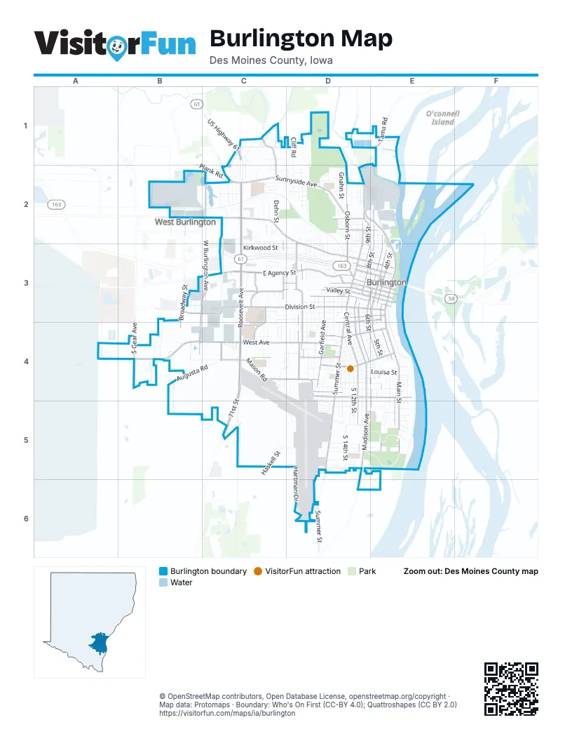
Street index of Burlington
Each street on the sheet and the grid squares it crosses.
- Great River BridgeE3
- South Roosevelt AvenueC3, C4, C5
- North Roosevelt AvenueC2, C3
- 71st StreetC4, C5
- US Highway 61C1
- West AvenueA4, B4, C4, D4
- Division StreetB3, C3, D3, E3
- Summer StreetB2, D3, D4, D5, D6
- East Agency StreetC3, D3
- Mount Pleasant StreetC2, D2, D3
- South Main StreetE3, E4, E5
- Sunnyside AvenueC2, D2
- South Central AvenueD3, D4, D5
- West Burlington AvenueC2, B3, C3, B4
- Osborn StreetD2, D3
- Washington StreetC3, D3, E3
- Bluff RoadD2, E2, E3
- North Central AvenueD2, D3
- North 4th StreetE3
- Irish Ridge RoadC1, C2
- Maple StreetD3, E3, D4
- Des Moines AvenueD2
- Spring StreetD3, E3
- Columbia StreetD3, E3
- South Gear AvenueB4
- East Mount Pleasant StreetB2, C2
- North Main StreetE3
- West Mount Pleasant StreetB2
- Highway 99D1
- Holstein AvenueD3
- D M AvenueD2
- Madison AvenueD4, D5
- Mason RoadC4, D4
- Harrison AvenueD4, E4
- Valley StreetC3, D3, E3
- South Garfield AvenueD3, D4
- Market StreetC3, D3, E3
- South 8th StreetD3, D4, E4, E5
- North 8th StreetE2, D3, E3
- South StreetD4, E4
- South 3rd StreetE3, E4, E5
- South 5th StreetE3, E4, E5
- South 6th StreetD3, D4, E4
- Jefferson StreetD3, E3
- South 9th StreetD3, D4
- Angular StreetD4, E4
- South Plane StreetD3, D4
- Hagemann AvenueD3, D4
- North 6th StreetE2, D3, E3
- Dill StreetC4, D4
- North 5th StreetE3
- Curran StreetD2, D3
- Flint Hills DriveC3
- Elm StreetD3, E3
- Arch StreetD3, E3
- Terrace DriveC3, C4
- North 9th StreetD2, D3, E3
- Oak StreetD2, E2
- Jackson StreetD4
- Shields StreetC2, C3
- High StreetD3, E3
- Corse StreetD2
- Broadway StreetB2, B3, B4
- North Plane StreetD3
- Columbus DriveC3
- Johannsen DriveC4
- Howard RoadC4
- Tama RoadE1
- HarrisonD4
- Memorial Park RoadC2
- 6th Street RampD3, E3
- Plank RoadC2
- West Frontage RoadC2, C3, C4
- South 10th StreetD3, D4, D5
- South 14th StreetD4, D5
- East Frontage RoadC2, C3, C4
- Barret StreetD4, E4
- South 7th StreetD3, D4, E4, E5
- South Leebrick StreetD3, D4
- Louisa StreetD4, E4
- Hartman DriveD5, D6
- South 12th StreetD4, D5
- South Starr AvenueD3, D4
- South 4th StreetE3, E4, E5
- Hedge AvenueD4, D5, E5
- South 13th StreetD4, D5
- Acres StreetD4, E4
- Gnahn StreetD2, D3
- Kirkwood StreetC3, D3
- Pine StreetD4, E4
- Augusta RoadB4, C4
- Denmark StreetD4, E4
- Lucas AvenueC3, D3
- Aetna StreetD3
- Amelia StreetC3, D3
- North 7th StreetE2, D3, E3
- North Front StreetE3
- South 15th StreetD4, D5
- Locust StreetD4, E4
- Parkway DriveD5, E5
- Haskell StreetD4, C5
- Dunham StreetD5, E5
- Cliff RoadD1, D2
- Spruce StreetD4, E4
- South Main DriveD5, E5
- Mill Dam RoadD1, D2
- Dankwardt Park DriveD5, E5
- Cedar StreetD4, E4
- Franklin StreetD3, E3
- Koestner AvenueD5
- Smith StreetD3
- Dodge StreetD4
- Dehn StreetC2
- Court StreetD3, E3
- Iowa StreetD2, D3, E3
- Vineyard StreetC2, D2
- Monticello DriveB3, B4
- Blackhawk DriveD5, E5
- Florence AvenueC1, D1
- South Gunnison StreetD3, D4
- Sweeny AvenueD4, E4
- Vine StreetD4, E4
- North 3rd StreetE3
- Linden StreetD2, E2
- South Gertrude StreetD3, D4
- Walnut StreetD4, E4
- Willow AvenueC4
- Spray StreetD4
- South Marshall StreetD3, D4
- 91st AvenueE1
- Hillary StreetD5
- Lynnwood DriveD5
- River StreetE4, E5
- Bittersweet PlaceD1, D2
- North Gertrude StreetD2, D3
- Windsor CircleD5
- North StreetD3, E3
- South Adams StreetD3, D4
- Greenbrier DriveD4, D5
- Golf LaneD2
- Cascades LandingE5
- Potter AvenueE5
- Emmett StreetD2, D3
- Navajo StreetD5
- Melrose CourtC2, C3
- Canterbury DriveB4
- South 16th StreetD4, D5
- Lincoln StreetD2
- Brooks AvenueD5, E5
- Vogt StreetD2
- Burlington AvenueC3
- North Garfield AvenueD3
- Hunt RoadC5
- Lenox AvenueC2
- Ash StreetD2, E2
- Gratton StreetD2, D3
- Racine AvenueC2
- Orchard Meadow DriveC2
- Whitewood StreetD5, E5
- Sioux StreetD5
- Isabella AvenueC2
- Douglas AvenueC2
- Green StreetD4
- Highland AvenueD2
- Yoder DriveC1, C2
- Surrey RoadC1, C2
- Brooks StreetD2, D3
- Melvin AvenueC2
- North Gunnison StreetD3
- Perkins AvenueD4
- Clearview AvenueC3, C4, D4
- Crestview DriveE5
- Orchard StreetE4
- Legacy DriveC3
- South Woodlawn AvenueD3
- Charles StreetC2
- Park AvenueD5
- Bock StreetC2, D2
- Cambridge DriveC4
- Grove StreetD4
- Morningside DriveC4
- Miller StreetE4, E5
- Spiegel StreetD2, D3
- Conner AvenueD2
- Messiah DriveC4
- Robinson Heights DriveC2
- Lewis StreetD4, E4
- Weimer StreetC2
- Ashmun StreetD2
- Easy StreetC4
- Charette LaneD2
- Cottonwood CourtC2, C3
- Sunrise LaneC3, D3
- Indian TerraceD4
- Guenther StreetD2, D3
- Sunset AvenueD5
- Lawrence DriveC4
- Baumberger StreetD2
- Herman AvenueC3
- Thul StreetD2
- Argyle CourtC2, C3
- Cottage Grove AvenueC2
- Steuben StreetD2
- North 10th StreetD3
- Grube StreetD2
- Glendale DriveC4
- Deer Run DriveC2
- Birdie StreetD2
- Belmont CourtC2, C3
- Sylvania DriveC2
- White StreetD4
- Pond StreetD2
- Brouwer DriveB3
- Marietta StreetD3
- Gilbert StreetC4, D4
- Ridge RowD2
- Williams StreetD4
- Ironwood StreetD3, D4
- Shoquoquon DriveD5, E5
- Woodland DriveC1
- Cathmar StreetC4
- Gear StreetD2
- Remick StreetD3
- Frontage RoadB3, C3
- Mercer StreetD2, D3
- Ridgeview DriveC1
- Plank StreetD3
- River DriveE5
- Bartlett StreetD2
- Fleming CourtC3
- May AvenueD4
- Winter StreetB2
- Garden CircleC4
- Sycamore StreetD2, E2
- Crystal DriveD1
- Edwards StreetD2
- Whittier StreetD4, D5
- Laurel StreetD4, D5
- Caroline StreetD2, D3
- Concord DriveE5
- Northern DriveC2
- Delmar StreetD4
- Cash StreetD2, E2
- Airlane DriveD5
- Olive StreetD4
- 6th StreetE4, E5
- 107th StreetB2
- Schneider DriveE5
- Cascade TerraceE5
- Wapello RoadE1
- Subilbe AvenueC2, D2
- Dehner StreetD2, D3
- Shamrock DriveC2
- Wells StreetD3
- Higbee AvenueD4
- Hillary RoadC5, D5
- Indian Hills RoadB4
- Patterson StreetD3
- Diamond RidgeC2
- Hayes StreetC2, C3
- Chalfant StreetD3
- Erikson LaneC4, D4
- Fair Acres DriveC1
- Griswold StreetD2
- Herblo DriveC2
- Remey AvenueE4
- Elm CourtE4
- Mark LaneD2
- Quail Ridge DriveD1
- Meadowbrook DriveC3
- Cascade BoulevardE5
- Kenilworth CourtC2, C3
- Sterling DriveC4
- Wightman StreetD4, E4
- Greenwood DriveE5
- Sandell DriveE5
- Gerdes DriveD2
- Cameron StreetD3
- Sierra DriveB4
- North Marshall StreetD3
- Brick StreetD2
- Arbor View DriveD2
- Ballard StreetB2
- Heisey StreetD3
- Pilger AvenueD2
- Randall LaneC4
- Evergreen DriveC1, D1
- Ramsey StreetB2
- Cliffwood DriveC1, D1, D2
- Kroeger StreetD2, D3
- Mason LaneC4
- GarnetD2
- Hiller LaneC4, D4
- Cherry StreetD2
- Clay StreetE4
- Hayes CourtC3
- Dekalb StreetD2
- Winchester DriveC4
- Polk StreetE4
- Monroe StreetD2
Things to do on the Burlington map
Places on the map
- ALDI
- Aldo Leopold Middle School
- Aldo Leoppold Middle School Track
- Apollo Central School
- Aspen Grove Cemetery
- Baby Rush Island
- Bethany Evangelical Lutheran Church
- Black Hawk Elementary School
- Bluff Harbor Marina
- Bracewell Stadium
- Burlington Alternative High School
- Burlington Central Fire Station
- Burlington City Hall
- Burlington Golf Club
- Burlington High School
- Burlington High School Track
- Burlington Memorial Auditorium
- Burlington Police Department
- Burlington Post Office
- Burlington Public Library
- Burlington Regional Recreational Complex
- Burlington YMCA
- Burlington-Notre Dame High School Track
- Capitol Theater
- CB&Q Steam Engine 3003
- Community Field
- Crapo Park
- Dankwardt Memorial Park
- Edward Stone Middle School
- Fetter Island
- Izaak Walton Lake
- Notre Dame School District
- Perkins Park
- Riverside Park
- Sunnyside School
- West Lake
Next to Burlington
- West Burlington
© OpenStreetMap contributors, Open Database License, openstreetmap.org/copyright · Map data: Protomaps · Boundary: Who's On First (CC-BY 4.0); Quattroshapes (CC BY 2.0)















