

Iowa map
Des Moines County map
About 38,411 people live here (Census Bureau, 2024 estimate). The sheet's index lists 300 streets; US Highway 61, 155th Avenue and 250th Street cross the most grid squares. Things to do inside the boundary: Greater Burlington.
Open the map (PDF, US Letter)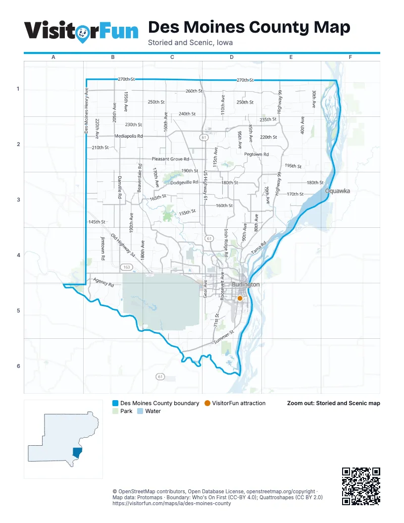
Maps inside Des Moines County
1 map inside, from the street map of Des Moines County down.
Street index of Des Moines County
Each street on the sheet and the grid squares it crosses.
- Great River BridgeD5
- US Highway 61C1, D1, C2, D2, D3, D4, D5
- 71st StreetD5, C6, D6
- Highway 61C6
- South Roosevelt AvenueD4, D5
- North Roosevelt AvenueD4, D5
- Highway 99E1, E2, E3, D4, E4
- Mediapolis RoadB2, C2, D2, E2
- Beaverdale RoadB2, B3, C3, C4
- 180th StreetB3, D3, E3, F3
- Pleasant Grove RoadB2, C2, D2
- Danville RoadB2, B3, B4
- Irish Ridge RoadD2, D3, D4
- 205th AvenueB1, B2, B3, B4
- 210th StreetB2, C2, D2, E2
- Summer StreetD4, D5, D6
- 165th StreetC2, B3, C3
- 190th AvenueB3, B4
- West Mount Pleasant StreetC4, D4
- Old Highway 34B4, C4
- 160th StreetB3, C3, D3, E3
- Dodgeville RoadC3, D3
- Division StreetD2, D5
- West AvenueC5, D5
- South Gear AvenueD4, D5
- Golden RoadB2, B3, C3
- South Main StreetB4, D5
- West Burlington AvenueD4, D5
- County Road H28B1
- East Agency StreetD4, D5
- Mount Pleasant StreetD4
- Sunnyside AvenueD4
- Diamond RoadB3
- South Central AvenueD5
- 406th RoadC4, C5
- Main StreetD2
- Osborn StreetD4, D5
- Washington StreetC4, D5
- West Agency RoadC5, D5
- Spring StreetD2, D4
- 162nd StreetB3
- Bluff RoadD4, D5
- North Central AvenueD4, D5
- Columbia StreetD2, C4, D5
- North Main StreetB4, D5
- North 4th StreetD4, D5
- Maple StreetD2, D5
- Augusta Main RoadC5
- Des Moines AvenueD4
- North Beaverdale RoadC4
- East Mount Pleasant StreetD4
- East Agency RoadD5
- D M AvenueD4
- 267th StreetB3
- Holstein AvenueD5
- Perkins RoadC5
- 260th StreetB1, C1, D1, E1, B3
- Iowa City RoadC2, C3, D3
- 160th AvenueC1, C2, B3, E3
- 170th StreetB3, C3, D3, E3
- Stony Hollow RoadD3, E3
- 145th StreetB3, C3, D3, E3
- 85th AvenueD1, D2, D3
- County Highway J20B4, C4, A5
- Sperry RoadD2
- South Prairie Grove RoadC4
- Tama RoadD4, E4
- 90th AvenueD1, D2, D3, D4
- 155th AvenueC1, C2, C3, C4, C5, C6
- 110th AvenueD1, D2, D3
- Washington RoadE2, C4, C5
- Falcon RoadD2, E2, D3, E3
- Flint Bottom RoadC4, D4
- Agency RoadB4, B5
- Madison AvenueD5
- Bridgeport RoadB4, B5
- 105th AvenueD2, D3
- 175th StreetD3, E3
- North Gear AvenueD4
- Y Camp RoadD4
- Plank RoadD4
- 188th StreetE3
- Valley StreetD2, D5
- Market StreetD2, C5, D5
- Golf Course RoadD4
- Broadway StreetD4, D5
- Mason RoadD5
- South StreetC1, D2, D5
- Harrison AvenueD5
- 60th StreetD5
- South Garfield AvenueD5
- South 8th StreetD5
- North 8th StreetD4, D5
- 103rd StreetC4
- South 3rd StreetD5
- Upper Flint RoadD4
- South 5th StreetD5
- 111th AvenueD2, D3
- South 6th StreetD5
- Jefferson StreetD5
- West Huston StreetD4
- Memorial Park RoadD4
- South 9th StreetD5
- Angular StreetD5
- South Plane StreetD5
- Hagemann AvenueD5
- North 6th StreetD4, D5
- Dill StreetD5
- North 5th StreetD4, D5
- High StreetD2, C4, D4, D5
- Curran StreetD4, D5
- Elm StreetD2, D5
- Flint Hills DriveD5
- Salem RoadA5
- Arch StreetD4, D5
- Terrace DriveD5
- North 9th StreetD4
- Oak StreetD4
- Jackson StreetD5
- Shields StreetD4, D5
- Corse StreetD4
- County Road 79B4
- North Plane StreetD4, D5
- East Huston StreetD4
- Columbus DriveD5
- Johannsen DriveD5
- Howard RoadD5
- HarrisonD5
- 6th Street RampD5
- 64th StreetD3
- 48th AvenueD3
- 250th StreetB1, C1, D1, E1, F1, B3
- 220th AvenueB1, B2, B3, B4, B5
- Skunk River RoadB5, C5, C6
- 240th StreetB1, C1, D1, E1, B2
- 270th StreetB1, C1, D1, E1
- 180th AvenueC1, C2, B4, C4
- Jimtown RoadB3, B4
- 235th StreetC2, D2, E2
- Des Moines-Henry AvenueB1, B2, B3, B4
- Pegtown RoadD2, E2
- 195th StreetB2, C2, E2
- 190th StreetB2, C2, D2, E2, F2
- Roosevelt StreetB4, C4
- 220th StreetD2, E2, F2
- 130th StreetB4, C4, D4
- 230th StreetB2, C2, E2
- 195th AvenueB1, B2
- 140th StreetB3, C3, B4, C4, D4, E4
- Morning Sun RoadC1, C2
- Meekers Landing RoadE2, F2
- 40th AvenueE1, E2, E3
- 205th StreetB2, C2, E2
- 155th StreetB3, C3, D3, E3
- Hunt RoadC5, D5, C6
- 135th StreetB4, C4
- North Prairie Grove RoadC3, C4
- 150th StreetC3, D3, E3
- Pumping Station RoadE1, F1
- 110th StreetB4
- 150th AvenueC1, C3, C4
- North Field RoadD1, D2
- 70th AvenueE2, E3
- Eagle RoadE2, E3
- Hawkeye RoadE1, E2
- Old Highway 61C1, D1, C6, D6
- 125th StreetB4, C4, D4
- 115th AvenueD2, D4, D5
- 245th StreetB1, D1
- Teal RoadC3
- 120th AvenueD1, D2, D3, D6
- Spring Lake RoadD6
- 170th AvenueC2, C3, C4
- 198th StreetB2, D2, F2
- Lake RoadE2
- 225th StreetE2
- 30th AvenueE1
- 95th AvenueD2
- 148th AvenueC2, C4, C5, C6
- Sullivan Slough RoadD5, D6
- 50th AvenueE1, E3
- 200th AvenueB5
- 152nd AvenueC2, C3
- 210th AvenueB3, B4, B5
- Huron RoadE1
- 80th AvenueD3, D4
- 140th AvenueC2, C3
- Rock Spring RoadC5, C6
- Mud RoadD1, D2
- 185th AvenueB2, B3, B4
- Hawk RoadD2
- Sycamore RoadB4, B5
- 50th StreetC5, D5
- West Frontage RoadD4, D5
- 154th AvenueC3, C4
- North StreetD2, C4, D4
- 145th AvenueC3, C4
- 75th AvenueD2, E2
- 135th AvenueC2, C3, C4
- Mill Dam RoadD4
- South 10th StreetD5
- Boundary AvenueC4
- Olympic RoadC2, C3
- Red BarnesE3, E4
- 172nd StreetB3, D3
- 92nd AvenueD1, D2, D3
- 182nd StreetD3
- 42nd AvenueE1
- Augusta RoadD5
- Pine StreetD2, D5
- South 14th StreetD5
- East Frontage RoadD4, D5
- Barret StreetD5
- South 7th StreetD5
- 55th AvenueE1, E3
- 151st AvenueC4
- 102nd AvenueD2, D4
- South Leebrick StreetD5
- Louisa StreetD5
- 78th AvenueD1
- 215th StreetC2
- 20th AvenueF2, F3
- Hartman DriveD5
- South 12th StreetD5
- Diversion ChannelE2, F2
- South Starr AvenueD5
- South 4th StreetD5
- Walnut StreetB2, D2, C4, C5, D5
- Hedge AvenueD5
- 130th AvenueC2
- South 13th StreetD5
- Kirkendall RoadC4
- 35th AvenueE1, E2
- Lynx StreetB3, C3
- Northfield RoadD1
- Acres StreetD5
- 158th AvenueC4
- Gnahn StreetD4
- Iowa StreetD2, C4, D4
- Locust StreetD2, D5
- Kirkwood StreetD4
- North Wapello StreetD2
- 202nd AvenueB4, B5
- 45th AvenueE3
- Pfeiff RoadC4, D4
- Denmark StreetD5
- Haskell StreetD5
- Lucas AvenueD4
- Cliff RoadD4
- 115th StreetC4, D4
- Edgewater Beach RoadD4, E4
- Wapello RoadD2, D4
- Curve StreetD2
- Aetna StreetD5
- Amelia StreetD5
- Drive LaneD5
- 28th AvenueE2
- Country LaneC6
- Brush College RoadD5
- North 7th StreetD4, D5
- Middle StreetD2
- Koestner AvenueD5
- North Front StreetD4, D5
- 105th StreetB4
- South 15th StreetD5
- Franklin StreetD2, D4
- Clubhouse DriveD5
- Oak Hills DriveD5
- 72nd AvenueE2
- Parkway DriveD5
- 138th StreetD4
- Dunham StreetD5
- Oconnell Beach RoadD4
- Spruce StreetD5
- 65th StreetD5
- South Main DriveD5
- 165th AvenueC3, C4
- 127th AvenueD4
- Little Flint RoadC4
- Dankwardt Park DriveD5
- Cedar StreetD5
- Seven Ponds RoadD2
- Hidden Prairie RoadD4
- Ramsey StreetD4
- 192th StreetF2
- Nikonha PlaceD5
- South Ash StreetB4
- Ferres LaneD5
- 22nd AvenueF2, F3
- Smith StreetD5
- Dodge StreetD5
- 147th AvenueC4
- 107th StreetD4
- Dehn StreetD4
- Starrs Cave RoadD4
- Leffler StreetD4
- Court StreetD5
- Vineyard StreetD4
- Monticello DriveD5
- Blackhawk DriveD5
Things to do on the Des Moines County map
Places on the map
- Allen Green Refuge
- Aspen Grove Cemetery
- Augusta Wildlife Management Area
- Baby Rush Island
- Benton Township
- Big Hollow Campsite
- Big Hollow Lake
- Burlington
- Burlington Golf Club
- Burlington Township
- Concordia Township
- Danville
- Danville Township
- Flint Hills Golf Course
- Flint River Township
- Franklin Township
- Half Moon Lake
- Hickory Bend
- Huron Township
- Iowa Army Ammunition Plant
- Jackson Township
- Leopold Recreation Area
- Mediapolis
- Middletown
- Mississippi River Islands Wildlife Management Area
- O'connell Island
- Pleasant Grove Township
- Rush Island
- Seven Ponds Park
- Skunk River
- Skunk River Access
- Spirit Hollow Golf Course
- Starr's Cave State Preserve
- Sullivan Slough
- Tama Township
- Union Township
- Washington Township
- Welter Recreation Area
- West Burlington
- Yellow Springs Township
Next to Des Moines County
- Oquawka
© OpenStreetMap contributors, Open Database License, openstreetmap.org/copyright · Map data: Protomaps · Boundary: Who's On First (CC-BY 4.0); Quattroshapes (CC BY 2.0)















