

Iowa map
Cedar County map
About 18,231 people live here (Census Bureau, 2024 estimate). The sheet's index lists 300 streets; 175th Street, 130th Street and Rose Avenue cross the most grid squares. Things to do inside the boundary: Herbert Hoover National Historic Site and Herbert Hoover Presidential Library and Museum.
Open the map (PDF, US Letter)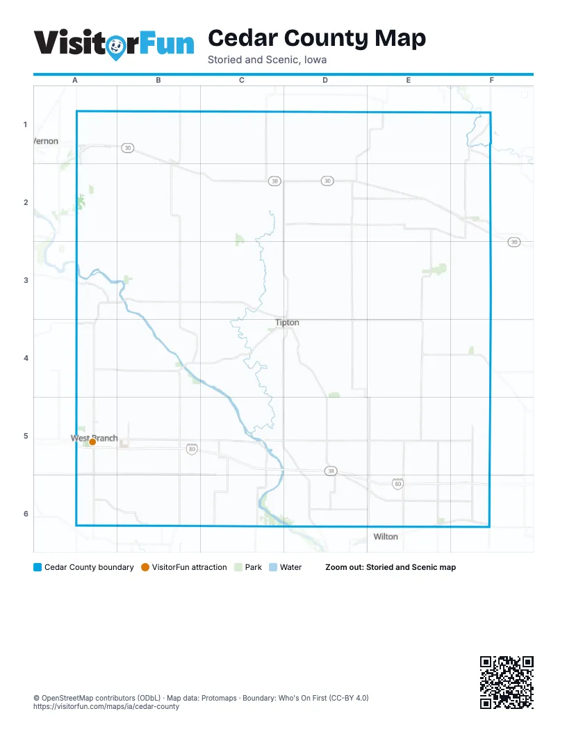
Maps inside Cedar County
1 map inside, from the street map of Cedar County down.
Street index of Cedar County
Each street on the sheet and the grid squares it crosses.
- Rose AvenueE1, E2, E3, D4, E4, D5, E5, E6
- State Highway 38C1, C2, C3, D3, C4, D4, C5, D5
- Hoover HighwayF1, E2, F2, E3, E4
- 240th StreetA4, C4, D4, E4, F4, F5
- Lincoln HighwayA1, B1, B2, C2
- State Highway 130D4, E4, F4
- Moscow RoadC4, D4, D5, D6
- Cedar StreetB3, D3, D4, E4, A5, C5, A6
- Lombard StreetD2
- East 7th StreetD4
- East 5th StreetD4, E4
- Ash StreetC2
- North Ash StreetC2
- South Ash StreetC2
- New Liberty RoadF4
- Taylor AvenueE1, E2, E3, E4, E5, E6
- 210th StreetF2, A3, B3, C3, D3, E3, F3, F6
- 290th StreetF4, A5, B5, C5, D5, E5, F5
- Garfield AvenueB1, B2, B3, B4, B5, B6
- 250th StreetA4, B4, D4, E4, F4
- Baker AvenueA2, A3, A4, A5, A6
- 160th StreetF1, A2, B2, C2, E2, F2
- Quincy AvenueD1, D2, D3, D4
- Washington AvenueF1, F2, F3, F4, F5, F6
- Yankee AvenueF1, F2, F3, F4, F5, F6
- 260th StreetA4, B4, C4, D4, E4, F5
- Union AvenueE1, E2, E3, E4, E5, E6
- 200th StreetB3, D3, E3, F6
- 165th StreetC2, D2, E2
- Cedar Valley RoadB4, C4
- Fox AvenueB1, B2, B5
- Oxford Junction RoadD1, E1, D2
- Harding AvenueB1, F2, B4, B6
- Green RoadB4, C4
- County Road F58E6, F6
- 5th StreetF2, E4, F6
- Main StreetC2, F2, B4, E4, A5
- 167th StreetE2
- 223rd StreetA4
- West Main StreetA5
- 7th AvenueD2, F6
- West South StreetB1, C4, D4
- East 1st StreetB1, B2, D4
- West 1st StreetB1, C4, D4
- West 9th StreetC3, D3
- Elm StreetB1, B2, B4, A5
- 14th AvenueF6
- East Main StreetA5
- Parkside DriveA5
- North Downey StreetA5
- Lisbon BoulevardA1
- North Washington AvenueF2
- County Road X64E1
- North Elm StreetB1, C2
- South Madison StreetB1, B2
- County Highway Y24F1
- 100th AvenueF1
- Downey StreetA5
- Bancroft AvenueA6
- 280th StreetE4, F4, A5, B5, C5, D5, E5, F5
- 300th StreetA5, B5, C5, D5, E5, F5
- Vermont AvenueE1, E2, E3, E4, E5, E6
- Delta AvenueB1, B2, B3, B5, B6
- 310th StreetA5, B5, B6, C6, E6, F6
- 230th StreetA4, B4, C4, D4, E4, F4, F6
- Charles AvenueA1, A2, A3, A4, A5, A6
- 330th StreetA6, B6, C6, D6, E6
- Monroe AvenueD1, C2, D2, D3, D4, D5, C6, D6
- Ocean AvenueD1, D2, D3, D4, D5, D6
- 190th StreetF1, A3, B3, C3, D3, E3, F3
- Indian AvenueC1, C2, C4, C5, C6
- 320th StreetA6, B6, C6, D6
- 150th StreetB2, C2, D2, E2
- Old Muscatine RoadD4, D5, D6, E6
- Old Lincoln HighwayA1, B1, B2, C2, E2, F2
- Cedar Scott Co Line RoadF4, F5, F6
- Adams AvenueA1, A2
- 325th StreetE6, F6
- Atalissa RoadC5, C6
- Ivory AvenueC4, C5, C6
- Johnson Cedar RoadA4, A5, A6
- Cedar Muscatine County Line RoadB6, C6
- Buckeye RoadA6, B6
- Cedar Clinton Co Line RoadF1, F2
- Cedar Muscatine Co Line RoadA6, B6, D6, E6
- Solon RoadA3
- 122nd StreetA1, F1
- Pine AvenueD1, D5, D6
- Inca AvenueC5
- Muscatine RoadD5, D6
- 100th StreetB6
- East Kirkwood BoulevardA1
- East South StreetB1, B2, D4
- 400th Street SoutheastA5
- Cedar Clinton RoadF2
- Spicer AvenueE2, E3, E4, E5, E6
- 120th StreetB1, C1, D1, E1, F1
- 270th StreetA5, B5, C5, D5, E5, F5
- Jackson AvenueC1, C2, C3, C4
- 110th StreetB1, C1, D1, E1
- King AvenueC1, C2, C3, C4, C5
- 130th StreetA1, C1, D1, E1, A2, C2, D2, E2, F2
- 175th StreetF1, A2, B2, C2, D2, F2, A3, B3, C3, D3, F3
- 220th StreetB3, F3, B4, C4, E4, F4, F6
- Grant AvenueB1, B2, F2, B3, B5
- Eureka AvenueB1, B2, B3, B4, B5, B6
- Franklin AvenueB1, B2, B4, B5, B6
- Echo AvenueB1, B2, B3, B4
- 140th StreetB2, D2, E2, F2
- Hayes AvenueC2, C3, C4, C5, C6
- National AvenueD1, D2, D3, D5, D6
- 155th StreetA2, B2, E2, F2
- 185th StreetA3, B3, C3
- 205th StreetC3, E3, F3
- Plato RoadA3, A4, B4
- Snaggy Ridge RoadC4, C5
- Kelly AvenueC2, C3, C5, C6
- Badger RoadA1, B1
- 180th StreetD3, E3
- Logan AvenueC3, C4, C5
- 195th StreetF2, C3, E3
- Plum AvenueD1, D2, D4, D5, D6
- Newton AvenueD2, D4, D5, D6
- Dixon AvenueB2, B3, B6
- Cedar Jones Co Line RoadA1, B1, C1, D1
- Red Star RoadD4
- 265th StreetA4, C5, D5
- 170th StreetB2, C2, E2
- 255th StreetB4, C4, D4
- 145th StreetA2, B2
- Stone Mill RoadC4
- 225th StreetB4, C5
- Taylor RoadE1, F1
- 125th StreetB1, C1
- Virginia AvenueE3, F3
- Jackson RoadC3
- Jefferson AvenueF2, C3, C6
- 4th StreetF2, E4, A5, C5, F6
- 305th StreetC5
- Cider AvenueA2, B2, B3
- Oak AvenueD1, D3
- Lemon AvenueC2, C4
- Garfield RoadB4, C4, C5
- 273rd StreetC5, D5
- 332nd StreetE6, F6
- West Rochester AvenueC5
- 177th StreetF2, E3, F3
- 235th StreetB4, C4
- 3rd StreetF2, B3, E4, C5, F6
- Roosevelt AvenueE1, F2
- 285th StreetC5
- Red Oak Park RoadC3
- 138th StreetA2, B2
- Plum StreetD3, D4
- 115th StreetA1
- Hayes RoadB4, C4
- 1st StreetB1, F1, F2, B3, B4, E4, C5, D5
- 6th StreetF2, E4, A5, F6
- 335th StreetE6
- Pond View DriveD5, E5
- 2nd StreetF1, F2, B3, E4, C5, F6
- 306th StreetD5
- 142nd StreetE2, F2
- 8th AvenueD2, F6
- Yankee RoadF3
- Walker RoadF2
- Witmer RoadC6
- Mulberry StreetD3, D4
- 7th StreetF2, F6
- Monroe RoadD4, D5
- Hidden River DriveC5
- Sycamore StreetD3, D4
- 315th StreetA6
- 8th StreetF2, F6
- Stoney AvenueE3, E4
- 143rd StreetA2, B2
- Wilson AvenueF5
- 307th StreetD5
- Cemetery RoadC5, D5
- Lynn StreetD3, D4
- Broadway StreetC2, D2, A6
- Belmont AvenueA3
- Lemon StreetC3, C4, A5
- East 2nd StreetB1, B2, D4
- 5th AvenueD2, F6
- West Orange StreetA5
- 1st AvenueC2, D2
- Ball StreetD2
- 9th AvenueD2, F6
- Smith StreetD2
- 6th AvenueD2, F6
- Walnut StreetB1, B2, D3, D4
- Locust StreetC3, C4, E4
- 3rd AvenueC2, D2, F6
- West 2nd StreetB1, C4, D4
- 326th StreetA6
- Park RoadD3, B4, D4, A5
- 28th StreetA5
- 173rd StreetC2, C3
- 2nd AvenueC2, D2, F6
- 4th AvenueD2, F6
- Meridian StreetD3, D4
- West 7th StreetC4, D4
- 201st StreetD3
- East 4th StreetB1, D4
- 238th StreetF3
- Orange StreetC3, C4
- Cedar Johnson RoadA5
- Green View DriveA5
- North Oliphant StreetA5
- 215th StreetA3
- State StreetB3
- Franklin RoadB3, B4
- Valley Forge DriveA1
- West 5th StreetC4, D4
- Washington StreetB1, E4, C5
- 297th StreetC5
- West 3rd StreetC4, D4
- Prairie View DriveA5
- Piatt StreetD2
- Hall AvenueF2
- West 4th StreetC4, D4
- 10th AvenueD2, F6
- East StreetD4, D5
- 10th StreetF2, F6
- Adams StreetA6
- Pleasant View DriveC4
- Country Estates DriveC3, C4
- Spruce StreetC4
- 11th AvenueD2, F6
- Crestview DriveB1, C3, A5
- Ames StreetD2
- 12th AvenueF6
- East Preston StreetC2
- West 6th StreetC4, D4
- West 8th StreetC3, D3
- Willow StreetE4
- Parkview DriveD3
- Hidden River CourtC5
- 275th StreetB5
- Dawson DriveA5
- East 6th StreetD4
- East College StreetA5
- Hoover BoulevardA5
- South Maple StreetC2, A5
- Maple StreetB4, E4
- North Walnut StreetB1, C2
- Airport RoadC4
- McKinley AvenueF2
- Timber LaneC5
- Koa DriveB5
- Scott DriveA5
- North Maple StreetC2, A5
- 113th StreetA1
- Bunker Hill DriveA1
- Irey AvenueC6
- 242nd StreetF4
- West StreetF1, C2
- East 3rd StreetD4
- Golfview DriveE6
- North 5th StreetA5
- Massillon RoadF1
- South 2nd StreetA5
- 9th StreetF2, F6
- North 1st StreetA5
- Council StreetA5
- 120th AvenueD1
- North AvenueD3
- Tidewater DriveA5
- Northridge DriveA5
- Madison AvenueD4
- North 4th StreetA5
- Sullivan StreetA5
- West 11th StreetD3
- East Cedar StreetB1, B2
- East 10th StreetD3
- North Poplar StreetA5
- East 8th StreetD3
- East North StreetC2
- East 9th StreetD3
- North Cherry StreetB1
- North Jefferson StreetB1
- Country View DriveB1
- Inland RoadD4
- 45th AvenueE1
- Cedar County RacewayC3
- East Broadway StreetC2
- Center StreetC2, A6
- Strawbridge Road NortheastA4
- 247th StreetC4
- North John StreetB1
- North 6th StreetA5
- East Oak StreetB1
- Pedersen StreetA5
- Horizon DriveD3
- 295th StreetC5
- Hubler LaneA2
- North Fayette StreetB1
- Johnson RoadC6
- 5th Street PlaceF2
Things to do on the Cedar County map
Places on the map
- 3/30 Golf & Country Club
- Bennett
- Bennett Park
- Cass Township
- Cedar Bluff Wildlife Area
- Cedar Valley Golf Course
- Cedar Valley Park
- Cedars Edge Golf Course
- Center Township
- Clarence
- Dayton Township
- Durant
- Fairfield Township
- Farmington Township
- Fremont Township
- Gower Township
- Inland Township
- Linn Township
- Lowden
- Lowden Quarry
- Massillon Township
- Mathews Memorial Airport
- Mcguire/Stonemill Quarry
- Mechanicsville
- Mink Run Wildlife Area
- North Cedar High School
- Pioneer Township
- Red Oak Township
- River Valley Wetland
- Rochester Township
- Rock Creek Timber
- Scattergood Friends School
- Springdale Township
- Springfield Township
- Stanwood
- Sugar Creek Township
- Tipton
- Townsend Wildlife Area
- West Branch
Next to Cedar County
- Lisbon
- Wilton
© OpenStreetMap contributors, Open Database License, openstreetmap.org/copyright · Map data: Protomaps · Boundary: Who's On First (CC-BY 4.0); Quattroshapes (CC BY 2.0)