

Iowa map
Cedar Rapids map
About 137,904 people live here (Census Bureau, 2024 estimate). The sheet's index lists 300 streets; Avenue of the Saints, Lincoln Freeway and 16th Avenue Southwest cross the most grid squares. Things to do inside the boundary: National Czech & Slovak Museum & Library.
Open the map (PDF, US Letter)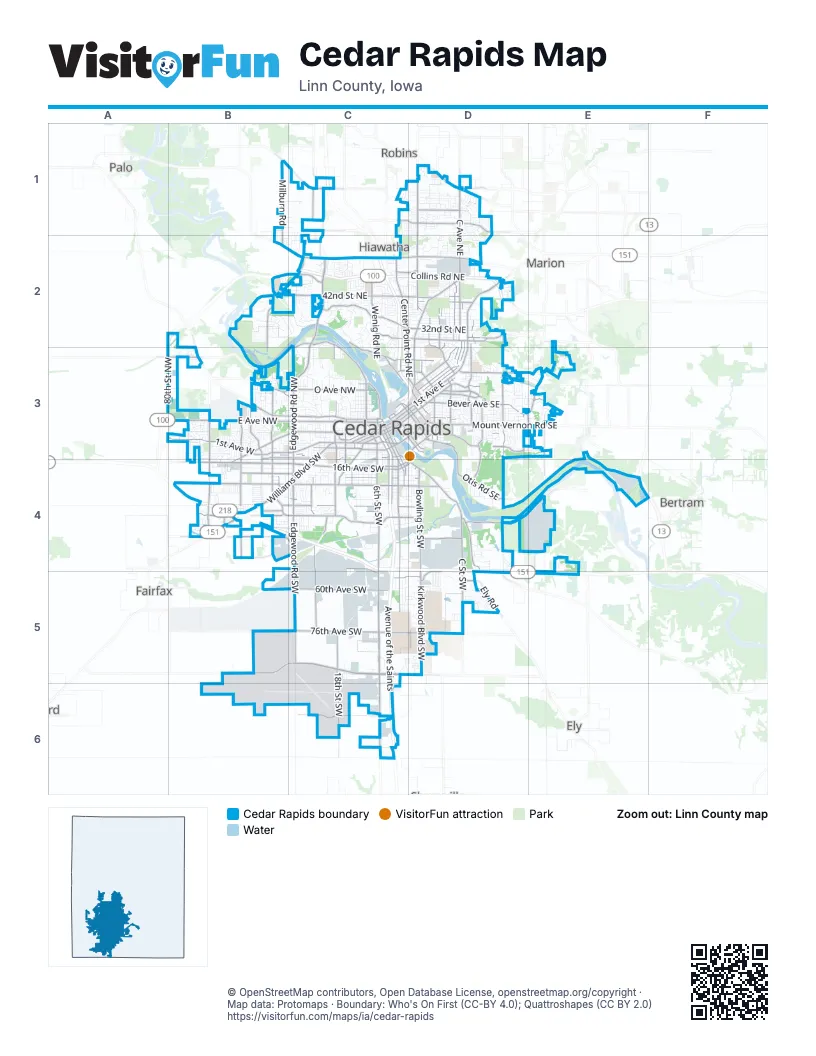
Street index of Cedar Rapids
Each street on the sheet and the grid squares it crosses.
- Avenue of the SaintsC1, C2, C3, D3, C4, C5, C6
- Collins Road NortheastC2, D2
- Lincoln FreewayC4, D4, D5, E5
- Juhl Drive NortheastC2
- Edgewood Road SouthwestC3, C4, C5
- 1st Avenue WestA3, B3, C3
- 1st Avenue EastD2, C3, D3
- Edgewood Road NorthwestC2, C3
- Mount Vernon Road SoutheastD3, E3
- Williams Boulevard SouthwestC3, B4, C4
- Edgewood Road NortheastC2
- 8th Avenue SouthwestC3
- 8th Avenue SoutheastC3, D3
- 10th Street SoutheastD3
- Williams Blvd SWB4
- Williams BoulevardB4
- Edgewood RoadC1, C2
- Diagonal Drive SouthwestC3
- Marion BoulevardD2
- 1st Avenue BridgeC3
- 16th Avenue SouthwestD3, B4, C4, D4
- 6th Street SouthwestC3, C4, C5, C6
- C Avenue NortheastD1, D2, C3, D3
- Wright Brothers Boulevard SouthwestC5, D5
- C Street SouthwestC3, C4, D4, D5
- E Avenue NorthwestB3, C3
- Wilson Avenue SouthwestB4, C4, D4
- 42nd Street NortheastB2, C2, D2
- Blairs Ferry Road NortheastC2, D2
- Kirkwood Boulevard SouthwestD5
- Council Street NortheastD1, D2
- F Avenue NorthwestB3, C3
- Center Point Road NortheastC2, C3, D3
- 2nd Avenue SoutheastD2, C3, D3
- 12th Avenue SouthwestB3, C3, D3, C4
- Boyson Road NortheastC1, D1
- Bowling Street SouthwestD4
- Oakland Road NortheastD2, D3
- Stoney Point Road SouthwestB3, B4
- 6th Streeet SouthwestC4, C5
- 3rd Avenue SoutheastD2, C3, D3
- 32nd Street NortheastC2, D2
- 3rd Street SouthwestC3, C4
- Wright Brothers Boulevard WestB5, C5
- L Street SouthwestC3, C4
- Cottage Grove Avenue SoutheastD3, E3
- 12th Avenue SoutheastD3
- 29th Street NortheastC2, D2
- 15th Avenue SouthwestD3, C4, D4
- 19th Street SoutheastD3
- East Post Road SoutheastD3, E3
- Tower Terrace RoadB1, C1, D1
- 1st Street SouthwestC3, C4
- 2nd Avenue SouthwestB3, C3
- 1st Street NorthwestC3
- 3rd Avenue SouthwestC3
- Old Marion Road NortheastD2
- 30th Street Drive SoutheastD2
- 7th Street SoutheastC3, D3
- Coldstream Avenue NortheastC2
- 8th Street SoutheastD3
- Ely RoadD5
- Boyson RoadC1, D1
- Stoney Point Road NorthwestB3
- Blairs Ferry RoadB2, C2, D2
- 5th Avenue SouthwestC3
- 13th Street SouthwestC3, C4
- Covington RoadB3
- Miller RoadC1, C2
- 29th Street Drive SoutheastD2
- Coe Road NortheastD3
- 12th Street SoutheastD3
- 3rd Street NorthwestC3
- College Drive NortheastD3
- 8th Street NortheastC3, D3
- Wright Brothers BoulevardD5
- 7th Street NortheastC3
- 2nd AvenueC2, C3
- Lakeside RdE2
- 13th Street SoutheastD3
- Stoney Pointe Road NorthwestB3
- 3rd Avenue BridgeC3
- 2nd Avenue BridgeC3
- Center Point RoadC2
- 3rd AvenueC3
- Highway 965 NorthwestC6
- 18th Street SouthwestC3, C4, C5, C6
- 76th Avenue SouthwestB5, C5, D5
- 33rd Avenue SouthwestB4, C4, D4
- J Street SouthwestC4, C5
- E Avenue NortheastD2, D3
- Bever Avenue SoutheastD3, E3
- Johnson Avenue NorthwestB3, C3
- A Avenue NortheastD2, C3, D3
- Ellis Boulevard NorthwestC3
- Otis Road SoutheastD3, D4
- 20th Avenue SouthwestB4, C4, D4
- West Post Road SouthwestB3, B4
- 60th Avenue SouthwestC5
- 26th Street SouthwestC4, C5
- 29th Avenue SouthwestB4, C4, D4
- J Avenue NortheastC2, C3, D3
- Old River Road SouthwestD4, E4
- 34th Street SoutheastD3
- O Avenue NorthwestC3
- Glass Road NortheastC2
- B Avenue NortheastD2, C3, D3
- Wenig Road NortheastC2, C3
- Milburn RoadB1, B2
- Memorial Drive SoutheastD3, D4
- Walford RoadC6
- Forest Drive SoutheastD3
- Wiley Boulevard SouthwestB3, B4
- Ellis Road NorthwestC2, B3, C3
- Blake Boulevard SoutheastD3
- Grande Avenue SoutheastD3
- 80th Street NorthwestA3, B3
- 2nd Street SouthwestC3, C4
- Seminole Valley Road NortheastB2, B3
- 18th Street NorthwestC2, C3
- Ely Road SouthwestD4
- Wiley Boulevard NorthwestB3
- Miller Avenue SouthwestC5, D5
- Jacolyn Drive NorthwestB3
- Rockford Road SouthwestC3, C4
- 15th Street SoutheastD3
- Rogers Road NorthwestB3, C3
- Ellis RoadA3, B3
- Prairie Drive NortheastD2, D3
- 42nd Street SoutheastD3
- 2nd Street SoutheastC3, D3
- 74th Street NortheastD1
- 3rd Street SoutheastC3, D3
- 76th Avenue Drive SouthwestD5
- 41st Avenue Drive SouthwestD4
- H Avenue NortheastD2, C3, D3
- Miller Road NortheastC1
- Eastern Avenue NortheastD2, D3
- Dean Road SouthwestB4
- Ushers Ferry Road NortheastB2, C2
- 16th Street NortheastD3
- Linden Drive SoutheastD3
- Pioneer Avenue SoutheastD3
- Waconia Avenue SouthwestC4, C5
- East Main StreetD1
- 31st Avenue SouthwestB4, C4
- A Avenue NorthwestC3
- 27th Street SouthwestC4
- Shaver Road NortheastC3
- North River Boulevard NortheastC2
- 40th Street NortheastD2
- Beverly RoadB4, C4
- Bertram Road SoutheastE3, E4
- West Post Road NorthwestB3
- Westdale Drive SouthwestB4, C4
- 15th Avenue SoutheastD3
- Beverly Road SouthwestB4
- McCarthy Road SoutheastD3
- Johnson Avenue SouthwestB3, B4
- Wilson Avenue Drive SouthwestD4
- 51st Street NortheastC2, D2
- 15th Street SouthwestC3, C4
- 20th Street NortheastD3
- East Robins RoadD1
- 21st St SWC4
- Jacolyn Drive SouthwestB3, B4
- 1st Street SoutheastC3
- 15th Street NorthwestC3
- 11th Street NortheastC3, D3
- Prairie Campus Road SouthwestD5
- Nursery RoadB4
- Penn Avenue NorthwestC3
- Wilson Ave SWB4
- 44th Street SoutheastE3
- Honey Grove RoadE4, E5
- 3rd Street NortheastC3
- Wiley Blvd SWB4
- Pro Farmer Road SouthwestB4
- H Street SouthwestC3
- 1st Street NortheastC3
- 76th Avenue Southwest RoundaboutD5
- Lone Willow Drive SouthwestD5
- Ivanhoe RoadD5
- Praire Campus Road SouthwestD5
- 18th Avenue SouthwestB4, C4, D4
- 5th Avenue SoutheastC3, D3
- 4th Avenue SoutheastC3, D3
- F Avenue NortheastD2, D3
- 21st Avenue SouthwestB4, C4, D4
- 12th Street SouthwestC3, C4
- Cherry Valley Road SouthwestB5, B6
- 26th Street NorthwestC2, C3
- 4th Street SouthwestC3, C4, C5
- 8th Street NorthwestC3
- 13th Street NorthwestC3
- 10th Street NorthwestC3
- 19th Avenue SouthwestC4, D4
- Tower LaneD1, D2
- D Avenue NortheastD2, D3
- 9th Street NorthwestC3
- 22nd Avenue SouthwestB4, C4, D4
- 30th Street SoutheastD3
- 37th Avenue SouthwestB4, C4
- 34th Street NortheastC2, D2
- 14th Avenue SoutheastD3
- Midway Drive NorthwestB3, C3
- Brentwood Drive NortheastD1, D2
- 16th Street SoutheastD3
- 66th Avenue SouthwestC5, D5
- 10th Avenue SouthwestC3
- 11th Street NorthwestC3
- 11th Street SouthwestC3, C4, C5
- 29th Street NorthwestC3
- 17th Street SoutheastD3
- 14th Avenue SouthwestC4
- Tissel Hollow Road SouthwestB6
- G Avenue NortheastD2, C3, D3
- 35th Street NortheastD2
- 27th Avenue SouthwestC4, D4
- 18th Street SoutheastD3
- M Avenue NorthwestB3, C3
- 20th Street NorthwestC3
- Seminole Valley Trail NortheastB2, C2
- Westdale Parkway SouthwestB4, C4
- B Avenue NorthwestC3
- 27th Street NortheastD2, D3
- Dalewood Avenue SoutheastD3
- 8th Street SouthwestC3, C4, C5
- 19th Street NorthwestC3
- Underwood Avenue SouthwestB3
- 33rd Street NortheastD2
- 9th Street SouthwestC3, C4
- Westwood Drive NorthwestC3
- Arthur Collins Parkway SouthwestC5
- River Parkway NortheastB2, C2
- Rockwell Drive NortheastD2
- Washington Avenue SoutheastD3
- 7th Avenue SoutheastC3, D3
- 6th Avenue SoutheastC3, D3
- 30th Street NortheastD2
- A Street SouthwestC3, D3, D4
- 9th Avenue SouthwestC3
- 36th Street SoutheastD3
- C Avenue NorthwestC3
- Meadowbrook Drive SoutheastD3
- Northwood Drive NortheastC2
- 16th Avenue SoutheastD3
- Old Orchard Road NortheastC2
- 31st Street SoutheastD3
- 21st Street SoutheastD3
- Muirfield Drive SouthwestD5
- Zika Avenue NorthwestC3
- Staub Court NortheastD2
- Brookland Drive NortheastC2
- Westchester Drive NortheastC2
- 7th Street SouthwestC3, C4, C5
- Kirkwood North Road SouthwestD5
- Square D DriveC4
- Johnson View Parkway SouthwestD5
- L Avenue NorthwestC3
- Richmond Road NortheastC2, D2
- 5th Street SoutheastC3, D3
- 6th Street SoutheastC3, D3
- 6th Street NorthwestC3
- Ohio Street SouthwestC5
- Riverside Drive NortheastC2
- Crescent View Drive NortheastD1
- 31st Street SouthwestC3, C4
- 26th Avenue SouthwestC4, D4
- Edgewood Parkway SouthwestC4
- South Prairie Road SouthwestC5, D5
- Sue Lane NorthwestB3, C3
- Gordon Avenue NorthwestB3
- 11th Avenue SoutheastD3
- Decatur Street SouthwestB4
- 26th Street SoutheastD3
- Country Club Parkway SoutheastD3
- 38th Street SoutheastD3
- Towne House Drive NortheastC2
- Leisure Boulevard NortheastC2
- Hillside Drive NorthwestC3
- Kirkwood Parkway SouthwestD5
- Greenfield Street NortheastD2
- 17th Street NortheastD3
- 16th Street NorthwestC3
- 7th Avenue SouthwestC3
- Chandler Street SouthwestC3, C4
- Sierra Drive NortheastC2, C3
- Mallory Street SouthwestD4
- Atlantic Drive SouthwestC5, C6
- I Avenue NortheastC3, D3
- Williams ParkwayC4
- K Street SouthwestC3, C4
- Circle Drive NortheastC2
- Red Fox Road SoutheastD3
- Grand Oaks Drive NortheastD1
- Center Street NortheastD2
- 27th Street NorthwestC3
- Maplewood Drive NortheastD2, D3
- Cherry Hill Road NorthwestB3
Things to do on the Cedar Rapids map
Places on the map
- ABC Disposal
- Aegon Holding Group
- Bever Park
- Beverly Park
- Bowman Square
- Brucemore Historical Site
- Cedar Lake
- Cedar Lake Park
- Cedar Park Memorial Cemetery
- Cedar Rapids Country Club
- Cedar Rapids South Quarry
- Cedar Rapids/Linn County Solid Waste Agency
- Cherry Hill Park
- Correctional Services Complex
- Cottage Grove Parkway Park
- Eastern Iowa Airport
- Ellis Golf Course
- Ellis Park
- Elmcrest Golf & Country Club
- First Assembly of God
- Flaherty Gardens
- Hawkeye Downs
- Jones Golf Course
- Kenwood Park
- Kingston Village
- Kirkwood Community College
- Manhattan-Robbins Lake Park
- MedQuarter
- Mount Trashmore
- New Bohemia & Czech Village
- Noelridge Park
- Prairie Creek Park
- Prairie Park
- Prairie Park Fishery
- Riverfront Park
- Saint Andrews Golf Course
- Seminole Valley Park
- Time Check Greenway
- Van Vechten Park
- Westdale
Next to Cedar Rapids
- Bertram
- Ely
- Fairfax
- Hiawatha
- Marion
- Palo
- Robins
© OpenStreetMap contributors, Open Database License, openstreetmap.org/copyright · Map data: Protomaps · Boundary: Who's On First (CC-BY 4.0); Quattroshapes (CC BY 2.0)