

Iowa map
Dallas County map
About 115,343 people live here (Census Bureau, 2024 estimate). The sheet's index lists 109 streets; Northwest Granger Drive, N Avenue and 240th Street cross the most grid squares. Also on it: Acadia, Adams Township and Adel.
Open the map (PDF, US Letter)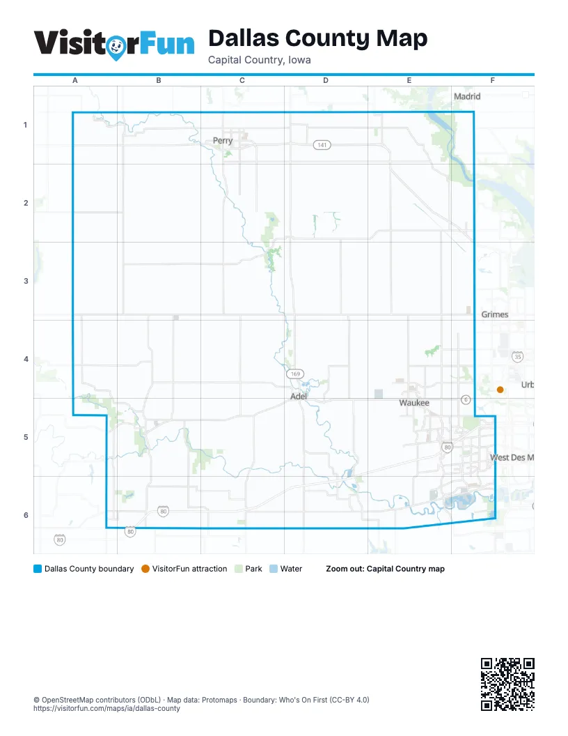
Maps inside Dallas County
1 map inside, from the street map of Dallas County down.
Street index of Dallas County
Each street on the sheet and the grid squares it crosses.
- George P. Soumas Memorial HighwayA1, B1, C1
- County Highway P46B1
- D AvenueB1, B2, B3
- East 3rd StreetB1
- East Forest AvenueB1
- North 1st StreetB1
- South 1st StreetB1
- 1st AvenueC1
- I CourtC1
- J AvenueC1, C2, C3
- Northwest Granger DriveC1, D1, E1, E2, F2, F3
- Park StreetC1
- West Willis AvenueC1
- Willis AvenueC1
- H AvenueD1
- N AvenueD1, D2, D3, D4, D5
- 334th RoadE1
- M AvenueE1
- North 3rd StreetE1
- North Main StreetE1, A4
- South AvenueE1
- South Main StreetE1
- Northwest 142nd StreetF1, F2, F5
- Northwest Madrid DriveF1
- State Highway 17F1
- Y AvenueF1
- Minburn RoadC2, D2, C3
- 195th StreetD2, E2
- 2nd StreetD2, B5
- 4th StreetD2
- 8th StreetD2
- Chestnut StreetD2
- County Highway F31D2
- Quinlan AvenueD2, D3
- 190th StreetE2, F2
- T AvenueE2, E3
- W AvenueE2, E3, E4
- State StreetF2, A6, B6
- 240th StreetA3, B3, C3, D3, E3
- Amarillo AvenueA3, A4
- 210th StreetB3, C3
- El Paso AvenueB3, B4, B5, B6
- K AvenueC3, C4, C5
- 13th StreetD3, D4
- 14th StreetD3
- Sugar Grove AvenueD3
- U AvenueE3, E4
- West 1st StreetE3, F3
- 270th StreetA4, B4
- County Highway F51A4
- East North StreetA4
- 280th StreetB4, C4
- North 15th StreetC4, D4
- Grove StreetD4
- Nile Kinnick Drive NorthD4
- Nile Kinnick Drive SouthD4, D5
- North AvenueD4, D5, D6
- R AvenueD4, D5, D6
- 10th StreetE4, E5
- 170th StreetE4
- Alice's RoadE4, E5
- Douglas ParkwayE4, F4
- Meredith DriveE4, F4
- North 10th StreetE4
- 142nd StreetF4, F5
- 310th StreetA5, B5
- 1st StreetB5
- 300th StreetB5, C5
- Bridge StreetB5
- Division StreetB5
- Thomas StreetB5
- County Highway 58C5
- Greene StreetC5, D5
- L AvenueC5, C6
- 290th StreetD5
- County Highway R16D5
- Hickman RoadD5, E5, F5
- 335th StreetE5
- 6th StreetE5
- Ashworth DriveE5
- Grand Prairie ParkwayE5, E6, F6
- Mills Civic ParkwayE5, F5
- Southeast Alice's RoadE5
- Southeast Grand Prairie ParkwayE5
- Southeast University AvenueE5, F5
- Ute AvenueE5, E6
- 60th StreetF5
- Ashworth RoadF5
- E P True ParkwayF5
- Jordan Creek ParkwayF5
- SE University AvenueF5
- South Jordan Creek ParkwayF5, F6
- University AvenueF5
- Brown StreetA6, B6
- County Highway P48A6
- 360th StreetB6, C6, D6, E6
- Marshall StreetB6
- 360th PlaceC6
- County Road P57C6
- I AvenueC6
- East StreetD6
- Elm StreetD6
- Guthrie StreetD6
- Mill StreetD6
- Richland RoadD6
- Badger Creek RoadE6
- Grand AvenueE6, F6
- Raccoon River DriveE6, F6
- Tabor RoadE6
Places on the map
- Acadia
- Adams Township
- Adel
- Adel Desoto High School
- Adel Estates
- Adel Township
- Alice Patricia Homes
- Allerton Park
- Amare Vita at Shadow Creek
- Angel Park
- Apple Waukee Data Center
- Ashley Acres
- Ashworth Acres
- Ashworth Crossing
- Ashworth Glen
- Aspen Valley
- Aspire Townhomes
- Athene
- Autumn Ridge Apartments
- Autumn Valley
- Bailey's Grove
- Barnes Heights
- Barrett Estates
- Bartlett Farm
- Bear Estates
- Beaver Lake State Wildlife Area
- Beaver Ridge
- Beaver Township
- BelleMeade Apartments
- Bent Creek Estates
- Bent Creek Meadows
- Bent Creek Ridge
- Bent Tree Crossing
- Berkshire Commons Office Park
- Berkshire Estates
- Berkshire North
- Berkshire Woods
- Big Bend Wildlife Management Area
- Biltmore
- Biltmore West
Next to Dallas County
- Clive
- Grimes
- Madrid
- West Des Moines
© OpenStreetMap contributors (ODbL) · Map data: Protomaps · Boundary: Who's On First (CC-BY 4.0)