

Iowa map
Des Moines map
About 213,096 people live here (Census Bureau, 2024 estimate). The sheet's index lists 195 streets; John MacVicar Freeway, Military Order of the Purple Heart Highway and Hubbell Avenue cross the most grid squares. Things to do inside the boundary: Iowa State Capitol and Pappajohn Sculpture Park.
Open the map (PDF, US Letter)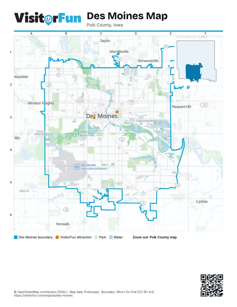
Street index of Des Moines
Each street on the sheet and the grid squares it crosses.
- Aurora AvenueA1, B1, C1
- Beaver AvenueB1, B2
- Lower Beaver RoadB1, B2
- Meredith DriveB1
- Merle Hay RoadB1, A2, A3
- 12th StreetC1, C2, C3
- 6th AvenueC1, C2, C3
- East Aurora AvenueC1
- Northeast Aurora AvenueC1, D1
- Northeast BroadwayC1
- Northwest 6th DriveC1
- Northwest Morningstar DriveC1
- Delaware AvenueD1, D2
- East 14th StreetD1, D2, D3
- John MacVicar FreewayD1, D2, A3, B3, C3, D3
- Mc Donald AvenueD1, D2
- Northeast 14th StreetD1
- Northeast 22nd StreetD1
- Northeast 29th StreetD1, D2
- East 38th StreetE1, E2
- East 46th StreetE1
- East Broadway AvenueE1
- Hubbell AvenueE1, D2, E2, D3
- Northeast 46th StreetE1, E2
- Sage StreetE1
- 63rd StreetA2, A3
- Douglas AvenueA2, B2
- Hickman RoadA2, B2, C2
- Madison AvenueA2, B2
- Merklin WayA2, B2
- Urbandale AvenueA2, B2
- 30th StreetB2, B3
- 41st streetB2
- 41st StreetB2
- 42nd StreetB2, B3
- 55th StreetB2, B3
- Euclid AvenueB2, C2
- Forest AvenueB2, C2
- Franklin AvenueB2, C2
- Leado AvenueB2
- Martin Luther King Junior ParkwayB2, C2, C3
- 19th StreetC2, C3
- 2nd AvenueC2, C3
- Arlington AvenueC2
- Birdland DriveC2
- Cornell StreetC2
- East 9th StreetC2, C3
- East Euclid AvenueC2, D2, E2
- East Washington AvenueC2, D2
- Pennsylvania AvenueC2, C3
- Saylor RoadC2
- Dixon StreetD2
- East 21st StreetD2, D3
- East 29th StreetD2, D3
- Easton BoulevardD2, E2, D3
- Guthrie AvenueD2
- Stewart StreetD2
- East 33rd StreetE2, E3
- East 42nd StreetE2
- East Douglas AvenueE2, F2
- Northeast 23rd AvenueE2
- Williams CourtE2
- Williams StreetE2, E3
- East 56th StreetF2
- Northeast 27th AvenueF2
- Northeast 56th StreetF2
- Northeast Oak Hill DriveF2
- 59th StreetA3
- 63rd Street;1st StreetA3
- Ashworth RoadA3
- Grand AvenueA3, B3, C3
- Ingersoll AvenueA3, B3, C3
- Railroad AvenueA3
- Southwest 63rd Street;1st StreetA3, A4
- University AvenueA3, B3, C3
- Vine StreetA3
- 31st StreetB3
- 35th StreetB3
- 56th StreetB3
- Center StreetB3, C3
- Cottage Grove AvenueB3, C3
- 10th StreetC3
- 15th StreetC3
- 16th StreetC3
- 17th StreetC3
- 18th StreetC3
- 3rd StreetC3
- 5th AvenueC3
- 7th StreetC3
- 8th StreetC3
- 9th StreetC3
- Ascension StreetC3
- Bancroft StreetC3
- Carpenter AvenueC3
- Court AvenueC3
- Crocker StreetC3
- Day StreetC3
- East 6th StreetC3
- East 7th StreetC3
- East Court AvenueC3, D3
- East Grand AvenueC3, D3
- East Jackson AvenueC3
- East Locust StreetC3
- East Martin Luther King Junior ParkwayC3, D3
- East University AvenueC3, D3, E3
- East Walnut StreetC3, D3
- Fleur DriveC3, C4, C5, C6
- Hartford AvenueC3, D3, D4
- High StreetC3
- Indianola AvenueC3, C4, D4, D5
- Indianola RoadC3
- Jackson AvenueC3
- Keosauqua WayC3
- Locust StreetC3
- Maury StreetC3, D3
- Mulberry StreetC3
- Park StreetC3
- School StreetC3
- Scott AvenueC3, D3, E3
- South Union StreetC3, C4, C5, C6
- Southeast 1st StreetC3, A5
- Southeast 6th StreetC3, C4
- Southwest 11th StreetC3
- Southwest 2nd StreetC3
- Southwest 3rd StreetC3
- Southwest 5th StreetC3
- Southwest 7th StreetC3
- Southwest 8th StreetC3
- Southwest 9th StreetC3, C4, C5, C6
- Thomas Beck RoadC3, C4
- Tuttle StreetC3
- Walnut StreetC3
- West Martin Luther King Junior ParkwayC3
- Woodland AvenueC3
- Dean AvenueD3, E3
- East 15th StreetD3
- East 18th StreetD3
- East 30th StreetD3
- Johnson CourtD3
- Redhead RoadD3
- Southeast 12th StreetD3
- Southeast 14th StreetD3, D4, D5
- Southeast 15th StreetD3
- Southeast 18th StreetD3
- Southeast 23rd StreetD3
- Southeast 25th CourtD3
- Southeast 30th StreetD3
- Vandalia RoadD3, E3, E4
- East Oakwood DriveE3
- McKinley AvenueA4, B4, C4
- Southwest 63rd StreetA4
- State Highway 28A4, A5, B5
- Veterans ParkwayA4
- Bell AvenueB4, C4
- George Flagg ParkwayB4, C4
- Park AvenueB4, C4
- Southwest 30th StreetB4
- Southwest 42nd StreetB4
- Southwest 56th StreetB4, B5
- East McKinley AvenueC4, D4
- East Park AvenueC4, D4
- East Watrous AvenueC4, D4, E4
- Southeast 5th StreetC4, C5
- Southwest 14th StreetC4, C5
- Watrous AvenueC4
- Easter Lake DriveD4, E4
- Evergreen AvenueD4, E4
- Southeast 22nd StreetD4
- Evergreen DriveE4
- Southeast 34th StreetE4
- Southeast 36th StreetE4, E5
- Southeast 40th StreetE4, E5
- Southeast 45th StreetE4, E5
- Southeast Brooks DriveE4
- Army Post RoadB5, C5
- Echo Valley DriveB5, C5
- Leland AvenueB5
- Military Order of the Purple Heart HighwayB5, C5, D5, E5, C6, D6
- Pine AvenueB5
- Willow Creek AvenueB5
- County Line RoadC5
- East Army Post RoadC5, D5, E5
- East County Line RoadC5, D5
- East Porter AvenueC5
- Porter AvenueC5
- Bloomfield RoadD5
- East Payton AvenueD5, E5
- East Pine AvenueD5, E5
- Southridge BoulevardD5, D6
- Hart AvenueE5
- Southeast 38th StreetE5
- Southeast Army Post RoadE5
- Border StreetC6
- Bronze StreetC6
- County Road R63C6
Things to do on the Des Moines map
Places on the map
- 5Fifty5
- Airport Commerce Park West
- Airport Park
- Albert Krysher's Addition
- Ape Cognition and Conservation Initiative
- Arie Den Boer Arboretum
- Army Post Road Plaza
- Arnold & Sweet's Addition
- Arthur Avenue Heights
- Ashbrook
- Ashby Park
- Ashley Square Apartments
- Ashworth Oaks
- Ashworth Park
- Auburn Heights
- Aviation Park
- Baker Creek
- Banbury
- Bates Addition
- Beaver Cove
- Beaver Heights
- Beaver Ridge
- Beaver Woods
- Beaverdale Park
- Bel Aire West
- Bell Place
- Belnor Heights
- Benlan Heights
- Berard Park
- Bethel Heights
- Bill Riley - Meredith Trail Open Space
- Billies Place
- Birdland Lagoon
- Birdland Marina
- Birdland Park
Next to Des Moines
- Altoona
- Carlisle
- Marquisville
- Norwalk
- Norwoodville
- Orillia
- Pleasant Hill
- Saylor
- Urbandale
- Valley Junction
- Windsor Heights
© OpenStreetMap contributors (ODbL) · Map data: Protomaps · Boundary: Who's On First (CC-BY 4.0)