

Iowa map
Polk County map
About 516,185 people live here (Census Bureau, 2024 estimate). The sheet's index lists 279 streets; Northeast 112th Street, Military Order of the Purple Heart Highway and Northeast 14th Street cross the most grid squares. Things to do inside the boundary: Adventureland, Iowa State Capitol and Living History Farms.
Open the map (PDF, US Letter)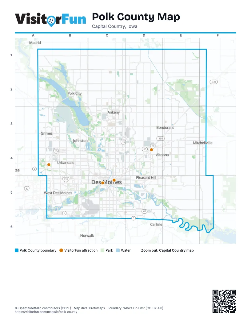
Maps inside Polk County
2 maps inside, from the street map of Polk County down.
City
Street index of Polk County
Each street on the sheet and the grid squares it crosses.
- Northwest 142nd StreetA1, A2, A4
- Northwest Madrid DriveA1, B1, B2
- State Highway 17A1
- 510th AvenueB1
- Boone StreetB1
- Northwest 142nd AvenueB1, C1
- Northwest 44th StreetB1, B2
- Northwest 58th StreetB1, B2
- Y AvenueB1
- Northeast 142nd AvenueC1
- Northeast 14th StreetC1, C2, C3, C4
- Northwest 16th StreetC1, C2, C3
- Northeast 150th AvenueD1
- Northeast 42nd StreetD1
- Northeast 46th StreetD1, D2, D3
- Northeast White Oak DriveD1
- Northeast 96th StreetE1, E2
- Northwest 106th AvenueA2, B2
- Northwest 118th AvenueA2, B2, C2
- Northwest 120th AvenueA2
- Northwest 121st StreetA2
- Northwest 122nd AvenueA2
- Northwest 128th StreetA2, A4, A5
- Northwest 135th StreetA2
- Northwest Granger DriveA2, A3
- East Northside DriveB2
- Mile Long BridgeB2
- North 3rd StreetB2
- North Broadway StreetB2
- Northwest 112th StreetB2
- Northwest Beaver DriveB2, B3, B4
- Northwest Polk City DriveB2, B3, C3
- Northwest Saylorville DriveB2, A3, B3
- Northwest Sheldahl DriveB2
- South 3rd StreetB2
- West Bridge RoadB2
- West Broadway StreetB2
- North Ankeny BoulevardC2, C3
- Northeast 118th AvenueC2
- Northeast 126th AvenueC2, D2, E2
- Northeast 18th StreetC2
- Northeast 36th StreetC2, D2
- Northeast Delaware AvenueC2, C3
- Northwest 18th StreetC2
- Northwest 36th StreetC2
- Northwest Irvinedale DriveC2, C3
- Northwest State StreetC2, C3
- East Walnut StreetD2
- North Grant AvenueD2
- South Grant AvenueD2
- West Walnut StreetD2
- Northeast 112th StreetE2, F2, E3, F3, E4, F4, F5
- Northeast 134th AvenueE2, F2
- Northeast 72nd StreetE2, E3, E4
- Northeast Hubbell RoadE2, F2, D3, E3
- Northeast Yoder DriveE2
- Yoder DriveE2
- East 1st StreetA3, B3, C3, D3
- North James StreetA3
- Northwest 114th StreetA3, B3, B5
- South James StreetA3, A4
- West 1st StreetA3, C3
- Grimes BoulevardB3
- Merle Hay RoadB3, B4
- Northeast Grimes BoulevardB3
- Northwest 66th AvenueB3, C3
- Northwest 70th AvenueB3
- Northwest 86th StreetB3, B4, B5
- Southeast Grimes BoulevardB3, B4
- Northeast 22nd StreetC3, C4
- Northeast 66th AvenueC3
- Northwest 26th StreetC3, C4
- Northwest 2nd StreetC3, C4
- Northwest 35th StreetC3
- Northwest 65th LaneC3
- Northwest 6th DriveC3, C4
- Northwest 78th AvenueC3
- Oralabor Road Frontage RoadC3
- South Ankeny BoulevardC3
- Southeast Corporate Woods DriveC3, D3
- Southeast Delaware AvenueC3
- Southeast Oralabor RoadC3, D3
- Southwest Irvinedale DriveC3
- Southwest Magazine RoadC3
- Southwest Oralabor RoadC3
- Southwest State StreetC3
- 2nd Street NorthwestD3, E3
- Northeast 78th AvenueD3, E3
- Northeast 94th AvenueD3, E3
- Northeast Hubbell AvenueD3, D4
- Southeast Four Mile DriveD3, D4
- 2nd Street NortheastE3
- 6th Street NorthwestE3, F3
- Grant Street NorthE3
- Grant Street SouthE3, E4
- Center Avenue NorthF3, F4
- 128th StreetA4
- 142nd StreetA4
- Douglas AvenueA4, B4, C4
- Douglas ParkwayA4
- Hickman RoadA4, B4, C4
- Meredith DriveA4, B4
- 100th StreetB4
- 55th StreetB4, B5
- 63rd StreetB4, B5
- 70th StreetB4
- 72nd StreetB4
- 73rd StreetB4, B5
- 86th StreetB4
- Beaver AvenueB4, C4
- Franklin AvenueB4, C4
- Merklin WayB4
- Northwest 100th StreetB4, B5
- Northwest Urbandale DriveB4
- University BoulevardB4, B5
- 12th StreetC4
- 19th StreetC4, C5
- 2nd AvenueC4, C5
- 30th StreetC4, C5
- 6th AvenueC4, C5
- Arlington AvenueC4
- Broadway AvenueC4
- Carpenter AvenueC4
- Delaware AvenueC4
- East 14th StreetC4, C5
- East 21st StreetC4, C5
- East Euclid AvenueC4, D4
- Easton BoulevardC4, D4, C5
- Euclid AvenueC4
- Forest AvenueC4
- Guthrie AvenueC4, D4
- Hubbell AvenueC4, D4, C5
- John MacVicar FreewayC4, A5, B5, C5
- Keosauqua WayC4, C5
- Martin Luther King Junior ParkwayC4, C5
- Northeast 46th AvenueC4, D4, E4, F4
- Northeast 54th AvenueC4, D4, F4
- Northeast BroadwayC4
- Northwest 46th AvenueC4
- Northwest 54th AvenueC4
- Northwest Morningstar DriveC4
- 34th Avenue SouthwestD4
- 8th Street SouthwestD4, E4
- Adventureland DriveD4, E4
- East 29th StreetD4
- East 38th StreetD4
- East 56th StreetD4
- East Broadway AvenueD4
- Military Order of the Purple Heart HighwayD4, D5, B6, C6, D6
- Northeast 23rd AvenueD4
- Northeast 29th StreetD4
- Northeast 38th StreetD4
- Northeast 56th StreetD4, D5
- 1st Avenue NorthE4
- 1st Avenue SouthE4
- 8th Street SoutheastE4
- Northeast 70th StreetE4, E5
- Northeast Broadway AvenueE4
- Center Avenue SouthF4
- Highway F48 WestF4
- Northeast 116th StreetF4
- Northeast 38th AvenueF4
- Northeast Mitchell DriveF4
- 60th StreetA5
- Ashworth RoadA5, B5
- E P True ParkwayA5, B5
- Grand AvenueA5, B5, C5
- Jordan Creek ParkwayA5
- Mills Civic ParkwayA5, B5
- Raccoon River DriveA5
- Ramp 72 DA5, B5
- Ramp 72 GA5, B5
- Ramp 72 HA5
- Ramp 72 IA5
- Ramp 72 JA5, B5
- Ramp 72 KA5
- University AvenueA5, B5, C5
- 22nd StreetB5
- 50th StreetB5
- 56th StreetB5
- 63rd Street;1st StreetB5
- 8th StreetB5, C5
- E.P. True ParkwayB5
- Ingersoll AvenueB5, C5
- Park AvenueB5, C5
- Railroad AvenueB5
- Ramp 72 EB5
- Ramp 72 FB5
- Ramp 72FB5
- South 50th StreetB5
- Southwest 42nd StreetB5, C5
- Southwest 63rd StreetB5
- Southwest 63rd Street;1st StreetB5
- State Highway 28B5, B6
- Valley West DriveB5
- Veterans ParkwayB5, B6
- 15th StreetC5
- 17th StreetC5
- 18th StreetC5
- 31st StreetC5
- 3rd StreetC5
- 7th StreetC5
- 9th StreetC5
- Ascension StreetC5
- Bancroft StreetC5
- Bell AvenueC5
- Center StreetC5
- Day StreetC5
- East 15th StreetC5
- East 6th StreetC5
- East Grand AvenueC5
- East Locust StreetC5
- East Martin Luther King Junior ParkwayC5, D5
- East McKinley AvenueC5
- East University AvenueC5, D5, E5, F5
- East Watrous AvenueC5, D5
- Evergreen AvenueC5, D5
- Fleur DriveC5, C6
- High StreetC5
- Indianola AvenueC5, C6
- Indianola RoadC5
- Johnson CourtC5
- Locust StreetC5
- Maury StreetC5, D5
- McKinley AvenueC5
- Park StreetC5
- Pennsylvania AvenueC5
- School StreetC5
- Scott AvenueC5
- Southeast 14th StreetC5, C6
- Southeast 1st StreetC5
- Southeast 5th StreetC5, C6
- Southeast 6th StreetC5
- Southwest 2nd StreetC5
- Southwest 3rd StreetC5
- Southwest 7th StreetC5
- Southwest 8th StreetC5
- Southwest 9th StreetC5
- Thomas Beck RoadC5
- West Martin Luther King Junior ParkwayC5
- East 30th StreetD5
- Easter Lake DriveD5
- Evergreen DriveD5
- Maple DriveD5
- North Hickory BoulevardD5
- North Pleasant Hill BoulevardD5
- South Pleasant Hill BoulevardD5
- Southeast 25th CourtD5
- Southeast 30th StreetD5
- Southeast 34th StreetD5
- Southeast 36th StreetD5, D6
- Southeast Vandalia DriveD5, E5, E6
- Vandalia RoadD5
- Northeast University AvenueE5
- Southeast 32nd AvenueE5, F5
- Camp DriveF5
- Northwest 12th AvenueF5
- Southeast 112th StreetF5
- Southeast 116th StreetF5, F6
- Southeast 32nd PlaceF5
- Southeast Camp DriveF5
- Army Post RoadB6, C6
- Echo Valley DriveB6, C6
- Southeast Willow Creek DriveB6
- Willow Creek AvenueB6
- County Line RoadC6
- East Army Post RoadC6, D6
- East County Line RoadC6
- Southridge BoulevardC6
- Southeast 60th StreetD6
- Southeast 64th AvenueD6, F6
- Southeast Army Post RoadD6
- Southeast Avon DriveD6
- Southeast 56th AvenueE6, F6
- Brown StreetF6
- East McKinney StreetF6
- Highway F70 WestF6
- Southeast 124th StreetF6
- State Highway 316F6
Things to do on the Polk County map
Places on the map
- 1900 Horse-Powered Farm
- 36 West
- Adam Ridge
- ADESA Des Moines
- Adventureland
- Adventureland Campground
- Adventureland Estates
- Adventureland Resort
- Airport Commerce Park West
- Albaugh Industrial Park
- Albertie Manor
- Alleman
- Alleman Country Estates
- Allen Township
- Alpine Village
- Altoona
- Altoona Crossing
- Altoona Estates
- Altoona Meta Data Center
- Altoona Village
- Andrews Meadow
- Ankeny
- Ankeny Centennial High School
- Ankeny Golf and Country Club
- Ankeny High School
- Ankeny Industrial Park
- Ankeny Regional Airport
- Antler Ridge
- Ape Cognition and Conservation Initiative
- Arbor Lake
- Arbor Oaks Estates
- Arbor Ridge
- Arie Den Boer Arboretum
- Arrow Ridge Point
- Ashawa Estates
- Ashbrook
- Ashland Meadows
- Ashland Meadows Park
- Ashland Ridge
- Ashton Pointe
Next to Polk County
- Carlisle
- Madrid
- Norwalk
© OpenStreetMap contributors (ODbL) · Map data: Protomaps · Boundary: Who's On First (CC-BY 4.0)