

Iowa map
Des Moines Township map
About 213,096 people live here (Census Bureau, 2024 estimate). The sheet's index lists 215 streets; Nature Road, R Avenue and Mamie Eisenhower Avenue cross the most grid squares. Things to do inside the boundary: Rail Explorers Boone.
Open the map (PDF, US Letter)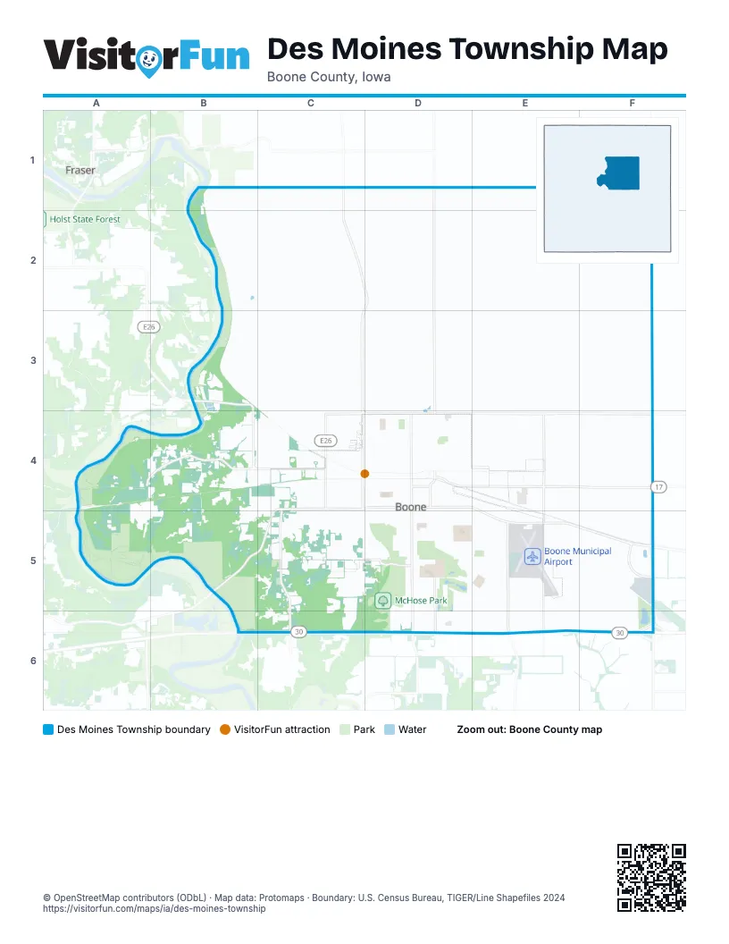
Street index of Des Moines Township
Each street on the sheet and the grid squares it crosses.
- 166th DriveB1, B2, C2
- 160th StreetC1, D1, E1, F1
- Nature RoadC1, C2, D2, C3, C4, D4
- P AvenueD1, D2, D3, D4
- Q AvenueE1, E2, E3, E4
- R AvenueF1, F2, F3, F4, F5, F6
- 170th StreetC2, D2, E2, F2
- 173rd LaneC2, D2
- Marigold LaneC2
- South AvenueF2, F3, F4
- 188th RoadB3
- Mallard AvenueB3, B4
- 180th RoadC3, D3
- 182nd LaneC3
- Monarch DriveC3, C4
- North AvenueC3
- 23rd StreetD3
- 24th StreetD3
- Boone StreetD3, D4, D5
- Marshall StreetD3, D4, D5
- Story StreetD3, D4, D5
- 180th StreetF3
- 193rd StreetA4, B4
- 198th RoadA4, B4
- 200th StreetA4, E4, F4
- Key LaneA4, A5
- L AvenueA4, B4, A5
- Lamb LaneB4, B5
- Lamb PlaceB4
- Larch LaneB4
- Macaw LaneB4
- Mango AvenueB4, B5
- Mink LaneB4
- West 12th StreetB4, C4
- West 3rd StreetB4, C4, B5
- 10th StreetC4, D4
- 11th StreetC4, D4
- 12th StreetC4, D4
- 13th StreetC4, D4
- 14th StreetC4, D4
- 15th StreetC4, D4
- 16th StreetC4, D4
- 17th StreetC4, D4
- 18th StreetC4, D4
- 22nd StreetC4, D4, E4
- 6th StreetC4, D4
- 7th StreetC4, D4
- 8th StreetC4, D4
- 9th StreetC4, D4
- Allison StreetC4
- Clay StreetC4, C5
- Coal RoadC4
- Division StreetC4, C5
- East 4th StreetC4, D4
- East AvenueC4, C5
- Franklin StreetC4, C5
- Fremont StreetC4, C5
- Grant StreetC4
- Hanley StreetC4
- JeffersonC4
- Jefferson StreetC4
- Main StreetC4, C5
- Mamie Eisenhower AvenueC4, D4, E4, E5, F5
- Marion StreetC4, C5
- McPherson StreetC4, C5
- Morton StreetC4
- Old Highway 30C4, C5
- Ringold StreetC4, C5
- Short StreetC4
- South Montana StreetC4, C5
- State StreetC4, C5
- Washington StreetC4
- Webster StreetC4, C5
- West 10th StreetC4
- West 11th StreetC4
- West 15th StreetC4
- West 16th StreetC4
- West 17th StreetC4
- West 18th StreetC4
- West 20th StreetC4
- West 22nd StreetC4
- West 4th StreetC4
- West 5th StreetC4
- West 6th StreetC4
- West 7th StreetC4
- West 8th StreetC4
- West 9th StreetC4
- West AvenueC4, C5
- West Mamie Eisenhower AvenueC4
- Wood StreetC4, C5
- 19th StreetD4
- 20th StreetD4
- 21st StreetD4
- 5th StreetD4
- Allen StreetD4
- Arden StreetD4
- Argo StreetD4
- Benton StreetD4, D5
- BrainardD4, D5
- Carroll StreetD4, D5
- Cedar StreetD4, D5
- Champa StreetD4
- Clinton StreetD4, D5
- Crawford StreetD4, D5
- Curtis StreetD4
- Delaware StreetD4, D5
- Factory StreetD4
- Greene StreetD4, D5
- Harrison StreetD4, D5
- Industrial Park RoadD4, E4
- Jackson StreetD4, D5
- Keeler StreetD4
- Linn StreetD4, D5
- Lowell CircleD4
- Meridian StreetD4
- Milwaukee StreetD4
- Monona StreetD4, D5
- Nebraska StreetD4
- Runyen StreetD4
- Tama StreetD4, D5
- Wilson StreetD4
- 190th StreetE4, F4
- Heinrich DriveE4
- Quartz AvenueE4, E5
- S AvenueF4, F5, F6
- 216th DriveB5, C5
- Maize AvenueB5
- West 1st StreetB5, C5
- West 2nd StreetB5, C5
- 1st StreetC5, D5, E5
- 217th LaneC5
- Ashworth CourtC5
- Candlewood DriveC5
- College StreetC5
- Destiny DriveC5
- East StreetC5
- Holbrook DriveC5
- Madison StreetC5
- Montana LaneC5
- Montana RoadC5, C6
- Park AvenueC5, D5
- Pine StreetC5
- South Division StreetC5
- South Freemont StreetC5
- South Main StreetC5
- South Marion StreetC5
- South Plum StreetC5
- South Ringold StreetC5
- South State StreetC5
- South StreetC5
- South Underhill StreetC5
- South Webster StreetC5
- South Williams StreetC5
- Southwest Ringold StreetC5
- Underhill StreetC5
- Walnut StreetC5
- West Lincoln AvenueC5
- West Park AvenueC5
- Westwood BoulevardC5
- Williams StreetC5
- 2nd StreetD5
- 3rd StreetD5
- Aldrich AvenueD5, E5
- Brookridge DriveD5
- Country Club DriveD5
- Crestwood DriveD5
- Doran CircleD5
- Doran DriveD5
- Forest AvenueD5
- Garst AvenueD5
- Hancock DriveD5, E5
- Kate Shelley DriveD5, D6
- Lincoln AvenueD5
- Lincoln WayD5
- Linden LaneD5
- Linwood DriveD5
- Park CircleD5
- Parkside DriveD5
- Parkway DriveD5
- Prairie AvenueD5
- South Benton StreetD5
- South Boone StreetD5
- South Cedar StreetD5
- South Clinton StreetD5
- South Delaware StreetD5
- South Greene StreetD5
- South Jackson StreetD5
- South Linn StreetD5, D6
- South Marshall StreetD5, D6
- South Ridge DriveD5
- South Story StreetD5, D6
- South Tama StreetD5
- Southeast Linn StreetD5, E5
- Southview CourtD5
- Union StreetD5, E5
- Woodland AvenueD5
- Aurora StreetE5
- Corporal Roger Snedden DriveE5, E6
- Eastgate DriveE5, E6
- Garst CircleE5
- Knezevich RoadE5
- SunriseE5
- 205th StreetF5
- 210th StreetF5
- Robin RoadF5
- 218th PlaceB6, C6
- Crown Flair DriveD6, E6
- Edgewood DriveD6
- Five Mile DriveD6, E6
- Hawkeye DriveD6
- Redbud DriveD6
- Southeast MarshallD6
- Timberlane DriveD6
- 220th StreetE6, F6
- 219th LaneF6
Things to do on the Des Moines Township map
Places on the map
- 15th Street
- AASF #1
- AASF #1 Helipad
- Ace Hardware
- Bass Point Cemetery
- Baymont Inn and Suites
- Bomgaars
- Boone
- Boone & Scenic Valley Railroad
- Boone County
- Boone County Fairgrounds
- Boone County Family Medicine
- Boone County Family Medicine North
- Boone County Historical Center
- Boone County Hospital
- Boone County Sheriffs Office
- Boone High School
- Boone High School Track
- Boone Memorial Garden
- Boone Middle School
- Boone Middle School Track
- Boone Municipal Airport
- Boone Post Office
- Boone Theatre
- Borgen Square Apartments
- Brookridge Drive
- Casey's General Store
- Cedar Pointe Golf Course
- church
- City Hall
- Des Moines Area Community College Boone Campus
- Des Moines Township
- Dickcissel Recreation Area
- Ericson Public Library
- Fareway
- Franklin School
- Goeppinger Field
- Herman Park
- Hy-Vee
- Iowa Army National Guard
Next to Des Moines Township
- Fraser
© OpenStreetMap contributors (ODbL) · Map data: Protomaps · Boundary: U.S. Census Bureau, TIGER/Line Shapefiles 2024