

Iowa map
Dubuque map
About 58,987 people live here (Census Bureau, 2024 estimate). The sheet's index lists 300 streets; Northwest Arterial, North Grandview Avenue and John F Kennedy Road cross the most grid squares. Things to do inside the boundary: Dubuque Arboretum and Botanical Gardens, Dubuque Museum of Art and Fenelon Place Elevator.
Open the map (PDF, US Letter)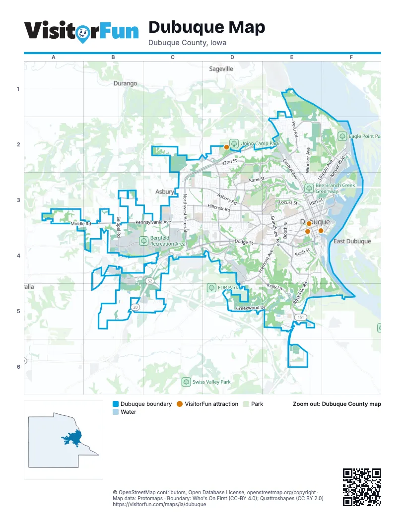
Street index of Dubuque
Each street on the sheet and the grid squares it crosses.
- Dubuque-Wisconsin BridgeF3
- Southwest ArterialC4, C5
- Northwest ArterialC2, D2, C3, C4
- Dodge StreetC4, D4, E4
- North Grandview AvenueD2, D3, E3, E4
- South Grandview AvenueE4
- Central AvenueE2, E3
- White StreetE2, E3
- Rockdale RoadE4, E5
- South Locust StreetE4
- Bellevue RoadE5
- Twin Valley DriveE5
- East 21st StreetE3
- Locust Street ConnE4
- Kerper BoulevardF2, F3
- Pennsylvania AvenueB3, C3, D3
- Asbury RoadB3, C3, D3
- John F Kennedy RoadC2, D2, D3, D4
- Kaufmann AvenueD3, E3
- University AvenueD3, E3, D4, E4
- Seippel RoadB3, B4, C4
- Rhomberg AvenueF2, E3, F3
- Elm StreetE2, E3
- Fremont AvenueD4, E4
- Cedar Cross RoadD4
- Old Highway RoadB4, C4
- Loras BoulevardE3
- West 5th StreetE3, E4
- Locust StreetE3, E4
- Bluff StreetE3, E4
- East 16th StreetE3, F3
- Hill StreetE3, E4
- North Cascade RoadD4, D5
- East 11th StreetE3, F3
- Bryant StreetE4
- East 5th StreetE3, F3, F4
- East 14th StreetE3, F3
- Wacker DriveD4
- Delhi StreetE3, E4
- West 9th StreetE3
- Fengler StreetE3, F3
- Maquoketa DriveE5
- East 9th StreetE3, F3
- West 1st StreetE4
- Olde Highway RoadB4
- Chavenelle RoadB4, C4
- West 32nd StreetD2, E2
- Carter RoadD2, D3
- Hillcrest RoadC3, D3
- Clarke DriveD3, E3
- Kane StreetD3, E3
- West 3rd StreetE4
- Peru RoadE1, E2
- Middle RoadA3, B3
- Radford RoadC3, C4
- Roosevelt StreetE2, F2
- Chaney RoadD3
- West Locust StreetE3
- Kelly LaneD4, E4, E5
- Crescent RidgeC4, D4
- Roosevelt RoadE2
- Lake Eleanor RoadE6
- Rosedale AvenueD3, E3
- English Mill RoadD4, C5
- Old Mill RoadE5
- East 22nd StreetE3
- Rosemont StreetC3
- Bell StreetF3, F4
- Hawthorne StreetF2
- Center Grove DriveD4
- North Crescent RidgeC4
- East 3rd StreetE4, F4
- East 32nd StreetE2
- East 20th StreetE3
- Public Safety WayB4
- Roosevelt Street WestE2
- Jackson StreetE2, E3
- Creekwood DriveD5, E5
- Lincoln AvenueF2, E3, F3
- Washington StreetE2, E3
- Garfield AvenueF2, E3, F3
- Windsor AvenueE2, E3
- Julien Dubuque DriveE4, E5, F5
- Southern AvenueE4, E5
- Main StreetE3, E4
- Iowa StreetE3, E4
- Shiras AvenueF2
- Holliday DriveC2, C3
- Chesterfield DriveB5, C5
- Kramer Circle DriveF2
- Arboretum DriveD2
- Alta Vista StreetE3, E4
- Key Way DriveD3
- Camelot DriveC3
- Admiral Sheehy DriveF3
- Miller RoadE5
- North Algona StreetE3, E4
- Saint Anne DriveD3
- Airborne RoadB4, B5
- Brunskill RoadD4
- Bunker Hill RoadD3
- Pinard StreetE2, E3
- Tanzanite DriveE2
- Valentine DriveD4, D5, E5
- Queen StreetE2, E3
- Van Buren AvenueD3, D4
- Graham CircleD3
- Arrowwood LaneD2
- Eagle Point DriveF1, F2
- North Booth StreetE3, E4
- Davis StreetE2
- Lake Ridge DriveD4
- Nevada StreetE3, E4
- Mount AlpineE2
- Manson RoadE5
- Marywood DriveD3
- Cleveland AvenueE4
- Greyhound Park RoadF3
- Stone Valley DriveC5
- Lowell StreetE3
- West 11th StreetE3
- Mar Jo Hills RoadE5
- Plaza DriveC2, C3
- East 12th StreetE3, F3
- Tiffany CourtD2
- Rush StreetE4
- Broadway StreetE3
- Associates DriveC3, C4
- Saint John DriveD3
- Westside DriveC4
- Avalon RoadD3
- Volunteer DriveF2
- Mount Loretta AvenueE4
- West 8th StreetE3
- West 17th StreetE3
- Plymouth CourtE4
- Southern Gate RoadF2
- Coates StreetD4, E4
- Alpine StreetE3, E4
- Matthew John DriveC3
- Green StreetD3, E3
- Sunlight RidgeE2
- Thomas PlaceF2, E3
- Harrison StreetE4
- Sheridan RoadE2
- Clark Crest DriveE3
- Mineral StreetD4, E4
- Arbor Hills DriveD2
- Mount Vail RidgeE2
- Sapphire CircleE2
- Embassy West DriveC3
- Auburn StreetE3, E4
- Bradley StreetE4
- Finley StreetD3, D4, E4
- Knob Hill DriveD4
- Wood StreetE3
- Justin LaneF2
- South Pointe DriveE5
- Olympic Heights RoadE2
- Burden StreetE2
- Langworthy StreetE4
- Glen Oak StreetE3, E4
- Crissy DriveD3
- Spring Valley RoadD3
- McCormick StreetE3, D4, E4
- Murphy Park DriveE4
- Mount Carmel RoadE4
- Digital DriveE6
- Century DriveD4
- Arrowhead DriveE4
- Shady Oaks DriveE4, E5
- Eclipse CircleD4
- Saint Joseph StreetD4, E4
- Valley StreetE4
- Riverview Park RoadF2, F3
- Simpson StreetD4, E4
- Atlantic StreetE3
- Westmark DriveC3
- East 15th StreetE3, F3
- Theda DriveD3
- Valeria StreetE3
- Saint Celia StreetD3
- Prescott StreetF2
- StaffordE3
- Hacienda DriveD3
- Castle Woods LaneD2
- Edmore LaneE1
- Bennett StreetE4
- West 16th StreetE3
- Cardinal DriveE2
- Pasadena DriveD3
- Lombard StreetE4
- Scenic View DriveD3
- High Bluff StreetF2, E3
- Lawther StreetE2
- Four Mounds LaneE1
- Coventry Park CircleD3
- Kirkwood StreetE3
- Angella StreetE3
- Bluebird DriveE2
- Golden Eagle DriveF2
- Oak Crest DriveE2, E3
- Bittersweet LaneD2
- Hale StreetE4
- Innovation DriveB4
- Marion StreetD4, E4
- Geraldine DriveD5, E5
- Millstone DriveC3
- Boyer StreetE2, D3, E3
- English LaneE4
- Dove StreetD3
- Pearl StreetD3, E3, D4
- East Commercial StreetF3
- East 7th StreetE3, F3
- Honeysuckle LaneD2
- Terminal StreetF4
- Edith StreetE2
- Aggie StreetC3, C4
- Inwood AvenueE2
- Muscatine StreetE2, E3
- Barbaralee DriveD4, D5
- Curtis StreetE4
- Wingate DriveD3, D4
- Admiral StreetC3
- Carriage Hill DriveD4, E4, E5
- University ParkwayD4, E4
- Swan DriveE2
- Adair StreetE3
- Wartburg PlaceE4
- Devon DriveD4
- Keymont DriveD3
- Amelia DriveE2, F2
- Brunswick StreetE2
- Jones StreetE4, F4
- West 4th StreetE3, E4
- Brookview SquareD4, E4
- Steamboat LaneE2
- Prince Phillip DriveE4
- Decorah StreetE3
- Keystone DriveC3, D3
- Indiana AvenueD3, D4
- Balboa DriveD3
- Peach Tree LaneD2
- Judson DriveD3
- St Ambrose StreetD3
- Flora Park DriveD3
- Glen OakE3
- Arbor Oaks DriveD3
- Wilson StreetE3, E4
- Ashley LaneD2, D3
- Jeffrey DriveD3
- O'Neill StreetE2
- East 24th StreetE3
- Vizaleea DriveD3
- Sunset Park CircleD3
- Mount Pleasant StreetE3
- Southway DriveD3
- Valley View RoadD3
- North Star DriveC3
- West 7th StreetE3, E4
- Delaware StreetE3
- Aerostar DriveE2
- Evergreen DriveD3
- Sylvan DriveD3, D4
- Jaeger DriveE5
- Sunset RidgeE4
- June DriveD5
- Ridgeway AvenueD3, D4
- Marjorie CircleC3, C4
- Princeton PlaceD4
- Blanche AvenueE2
- Woodlawn StreetD3
- Goethe StreetE2
- York StreetE4
- South Main StreetE4, F4
- Cora DriveC3
- Flora Park RoadD3
- Laurel StreetE4
- Bies DriveD3, D4
- Flamingo DriveE2
- Hawkeye DriveE2
- Stoltz StreetE2
- North Main StreetE3
- Chavenelle CourtC4
- Carmel DriveE4, F4
- Katrina CircleD3
- Saunders StreetE2
- Liberty AvenueE2
- Kennedy CircleD3
- Wildwood DriveE2
- Shiras Avenue ExtensionF2
- Fillmore StreetE3
- Keymeer DriveD3
- Wilbricht LaneD3
- Kerper CourtF3
- Southgate DriveD4
- West 12th StreetE3
- Chestnut StreetE3
- Hummingbird DriveC3
- Tower DriveE5
Things to do on the Dubuque map
Places on the map
- A.Y. McDonald Park
- Amazon Delivery WWI2
- Asbury Plaza
- Back Waters Amp
- Bee Branch Creek Greenway
- Bee Branch Pond
- Bee Branch Watershed
- Bergfeld Pond
- Bergfeld Pond Trail
- Bergfeld Recreation Area
- Blain's Farm & Fleet
- Bunker Hill Golf Course
- Dubuque City Hall
- Dubuque Country Club
- Dubuque County Courthouse
- Dubuque Senior High School
- Dubuque Soccer Complex
- Dubuque Technology Park
- Eagle Point Park
- Finley Hospital
- Flora Park
- Four Mounds Foundation
- Granger Creek Nature Trail
- Julien Township
- Kaufmann Avenue Prairie
- Kennedy Mall
- Kramer Circle Drive
- Linwood Cemetery
- Maus Park Lake
- Medical Associates Clinic
- Miller Riverview Park
- Mississippi Riverwalk
- Mount Calvary Cemetery
- Mount Carmel Convent
- Mount Saint Bernard Seminary
- Plaza 20
- Q Casino
- Slough Impoundment
- Veterans Memorial Park
Next to Dubuque
- Asbury
- Durango
- East Dubuque
- Sageville
© OpenStreetMap contributors, Open Database License, openstreetmap.org/copyright · Map data: Protomaps · Boundary: Who's On First (CC-BY 4.0); Quattroshapes (CC BY 2.0)