

Iowa map
Dubuque County map
About 99,242 people live here (Census Bureau, 2024 estimate). The sheet's index lists 300 streets; North Cascade Road, State Highway 136 and 1st Street North cross the most grid squares. Things to do inside the boundary: Dubuque Arboretum and Botanical Gardens, Dubuque Museum of Art and Fenelon Place Elevator.
Open the map (PDF, US Letter)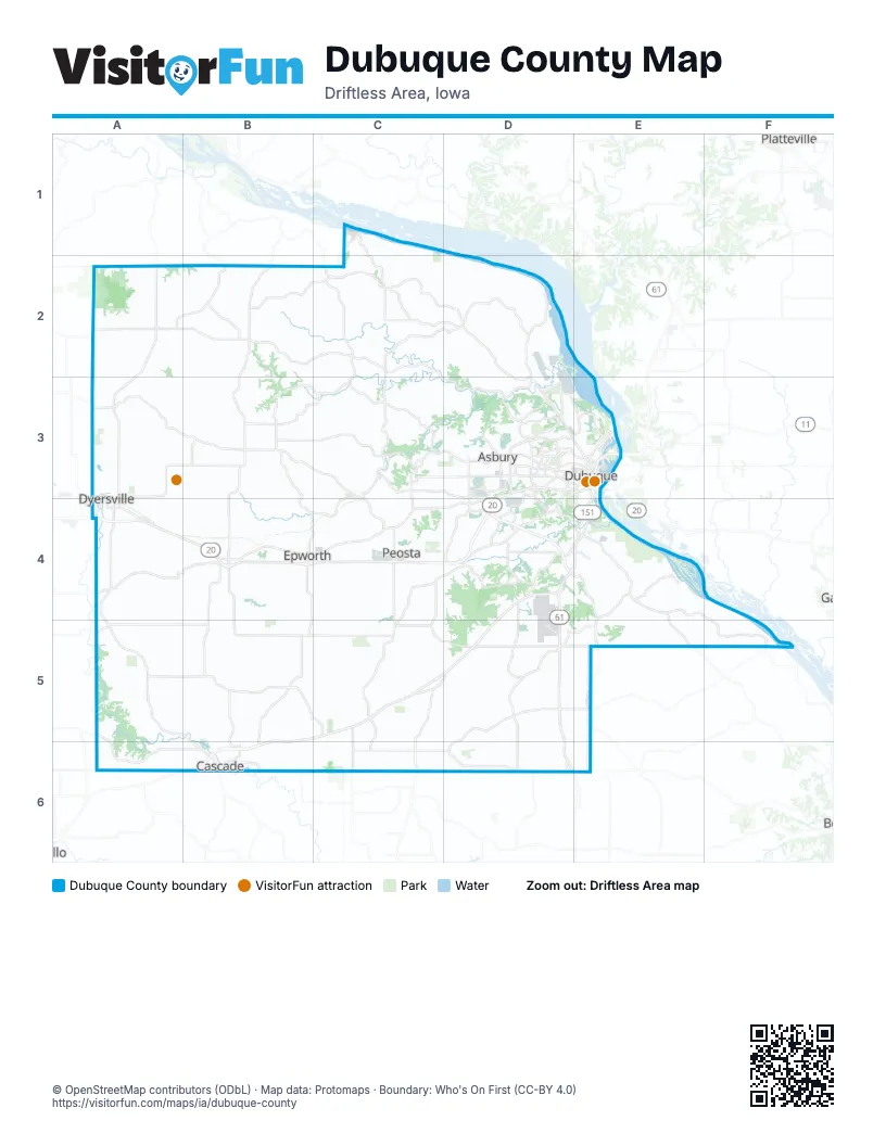
Maps inside Dubuque County
3 maps inside, from the street map of Dubuque County down.
City
Street index of Dubuque County
Each street on the sheet and the grid squares it crosses.
- Southwest ArterialD4
- Dubuque-Wisconsin BridgeE3
- State Highway 136A4, A5, B5, B6
- Northwest ArterialD3
- Dodge StreetD3, E3
- US 52A2, A3
- Great River RoadC2, E4, E5
- Olde Hawkeye RoadA4, B4
- North Grandview AvenueD3
- Central AvenueD3, E3
- South Grandview AvenueD3, E3, E4
- State Highway 3A2
- White StreetD3, E3
- Rockdale RoadE4
- 9th Street SoutheastA4
- East Main StreetA2, B4, C4
- West Main StreetA2, A3, B4
- South Locust StreetE3
- 1st Street NorthA3, A4, B4, A5
- Bellevue RoadE4
- 11th Street NortheastA3, A4
- 1st Street SouthB4, A5
- Columbus StreetA3
- Burtons Furnace RoadD3
- Johnson Street NorthwestB6
- 11th Street SoutheastA4
- North Andres StreetA2
- Johnson Street SouthwestB6
- Twin Valley DriveE4
- South Andres StreetA2
- East 21st StreetE3
- Locust Street ConnE3
- North Cascade RoadC4, D4, B5, C5, B6
- Asbury RoadB3, C3, D3
- Sundown RoadC3, C4, C5
- Old Highway RoadD3, B4, C4, D4
- Farley RoadB4, B5, B6
- Higginsport RoadD5, C6, D6
- Holy Cross RoadB2, B3, B4
- New Vienna RoadA3, B3
- Dyersville East RoadA3, B3
- Ridge RoadB2, C2, D3
- Balltown RoadC2, D2
- John F. Kennedy RoadD3
- Olde Davenport RoadE4, E5
- Olde Farley RoadA4, B4
- Bankston Park RoadB2, B3
- Sherrill RoadD2, D3
- Monastery RoadC5, D5
- 1st Street SouthwestA4, B4, B5
- East Worthington RoadA5, B5
- Swiss Valley RoadD4
- Skyline RoadD5, E5
- Bernard RoadC5, C6
- Kerper BoulevardE3
- Pennsylvania AvenueD3
- James RoadC2
- Seippel RoadD3, D4
- Callahan RoadC5, D5
- Military RoadD4
- Washington Mills RoadD6
- 1st Avenue EastA4, B4, A5, B6
- Kaufmann AvenueD3, E3
- Leuchs RoadB4
- 2nd Avenue SoutheastA4, B4, B6
- University AvenueD3, E3
- 1st Avenue WestA4, B4, A5, B6
- Tollgate RoadB2
- Curoe RoadC5, C6
- Schueller Heights RoadE4
- Feeney RoadD5, E5
- Rhomberg AvenueE3
- Twelve Mile RoadC5, D5
- Elm StreetA2, E3
- Aviation DriveD5
- South Garryowen RoadB6
- Clay Hill RoadD3
- Fremont AvenueD3, D4
- South John Deere RoadD3
- Haxybylane RoadD5, E5
- Toll Gate RoadB2
- Cedar Cross RoadD3, D4
- Laudeville RoadD5, E5
- Loras BoulevardD3, E3
- Molony RoadD6
- Airview DriveD5
- Peosta StreetE3, C4
- 3rd Avenue NortheastA3, A4, B4
- Wuchter RoadA4
- Garryowen RoadB6
- Key West DriveD4, E4
- West 5th StreetD3, E3
- Locust StreetE3
- Bluff StreetE3
- East 16th StreetE3
- West John Deere RoadD3
- Hill StreetA2, E3
- Airport RoadD4, D5
- Petersburg RoadA3
- North Buena Vista RoadC2
- Olde Highway RoadC4, D4
- Access RoadD3, C4
- 2nd Street SoutheastA4, B4
- Maquoketa DriveD4, E4, B6
- O'Rourke LaneD4, E4
- 5th Avenue NortheastA3, B4
- East 11th StreetE3
- Bryant StreetE3, E4
- East 5th StreetE3
- 1st Street NorthwestB4
- East 14th StreetE3
- Wacker DriveD3
- Delhi StreetD3
- West 9th StreetE3
- Fengler StreetE3
- East 9th StreetE3
- 1st Street EastA2
- Park Street SouthwestB4
- 300th StreetE6
- West 1st StreetE3
- 230th AvenueE5
- Monroe StreetB6
- Tollgate AvenueB2
- North Bankston RoadA3, B3, C3
- East Pleasant Grove RoadB5, C5
- Hickory Valley RoadB2, B3
- Bennettville RoadD5, D6
- Goose Hill RoadA5, A6, B6
- St Catherine RoadE4, F4, F5
- Olde Castle RoadA4, B4
- Clear Creek RoadA2, B2, A3
- Gun Club RoadB3, B4, C4
- Cedar Ridge RoadC3, D3
- Rockville RoadA4
- Thunder RoadA2, B2
- Park Hollow RoadC2, B3, C3
- Girl Scout RoadB3, C3, C4
- Five Points RoadC2, C3
- South Mound RoadC2, D2
- Circle Ridge RoadD2
- Mud Lake RoadD2, D3
- Humke RoadC3, D3, C4, D4
- Millville RoadC3, B4, C4
- Haberkorn RoadC2, D2
- St Joes Prairie RoadD4, D5
- Graf RoadC3, C4
- Olde Worthington RoadA4, A5
- Thielen RoadC3, C4
- Placid RoadB4, B5
- Hales Mill RoadD3
- Lake Eleanor RoadD4, E4
- English Mill RoadD3, D4
- South Waupeton RoadC1, C2
- Massey Station RoadE4
- Simon RoadB5, C5
- Cottingham RoadD4
- Budd RoadC3
- Kearney RoadB5
- Chavenelle RoadD3
- Middle RoadC3, D3
- Heiderscheit RoadB2
- Riegler RoadC2
- Hawkins RoadA5, B5
- Hannan RoadC3
- Peru RoadD3, E3
- West 32nd StreetD3
- Oakland Farms RoadD4
- Main StreetB2, A3, E3, D6
- Calonder RoadC3
- Whitetop RoadD4
- Carter RoadD3
- New Melleray RoadC4, C5
- Beltline RoadA3, A4
- Hillcrest RoadD3
- Roller Coaster RoadB5
- Clarke DriveD3, E3
- Kane StreetD3
- Rupp Hollow RoadD3
- Lost Canyon RoadD4
- Radford RoadD3
- Driscoll RoadC5, C6
- North English RoadD4
- West 3rd StreetD3, E3
- Roosevelt StreetE3
- 2nd Street NortheastA3, A4, B4, A5
- Potter Hill RoadC3
- 3rd Street SouthwestA4, B4
- Chaney RoadD3
- West Locust StreetD3, E3
- Kelly LaneD4, E4
- North Waupeton RoadC1
- Crescent RidgeD3
- 8th Avenue SoutheastA4, B6
- Kapp DriveC4
- Roosevelt RoadE3
- Waupeton RoadC1, C2
- Rosedale AvenueD3
- 1st Avenue NortheastB4
- 4th Street SoutheastA4, B4
- Old Mill RoadE4
- 3rd AvenueA5
- East 22nd StreetE3
- Rosemont StreetD3
- Center Avenue NorthB4
- Center Avenue SouthB4
- Bell StreetE3
- Hawthorne StreetE3
- Center Grove DriveD3
- North Crescent RidgeD3
- East 3rd StreetE3
- Cascade & Gear's Ferry RoadF5
- Errthum RoadB2
- East 32nd StreetD3, E3
- Centerville RoadE5
- Sand Springs RoadA5
- East 20th StreetE3
- Public Safety WayD3, D4
- Peosta Commercial CourtC4
- 272nd StreetA5
- County Road 734D3
- Roosevelt Street WestE3
- 343rd AvenueF5
- Pilot Grove RoadB4, C4
- Wente RoadA3, B3
- Dutch Lane RoadC4, C5
- Hartbecke RoadB4, B5
- Lambe RoadD5, D6
- Prier RoadA4, B4
- Flannagan RoadB2, C2
- Stoffel RoadC5, D5, C6
- Johns Creek RoadA5, B5
- Derby Grange RoadC3, D3
- Tom Lucas RoadA3, B3
- Steger RoadA5, B5
- Aitchison RoadB5, B6
- Kluesner RoadB2, B3
- Prairie Creek RoadC5, D5
- Fagan RoadD5
- Hochrein RoadC2, D2, D3
- Buncombe RoadD5, E5
- Fischer RoadC5, D5, D6
- Pfeiler RoadB2, C2
- Karper Harbor RoadB5
- Olde Massey RoadE4
- Hantelman RoadD2
- Boy Scout RoadC2, C3
- Mc Carthy RoadC5, C6
- Wieferich RoadA4, A5
- Heisler RoadB3, B4
- Mines of Spain RoadE4
- Colony RoadA2, A3
- Cox Springs RoadC4
- Finleys Landing RoadC1, C2, D2
- Horseshoe RoadC2
- Bierman RoadC4
- Jackson StreetA3, D3, E3
- Floyd RoadA3
- Schemmel RoadA5
- Comer RoadB4, B5
- Whitewater DriveC5, B6, C6
- Larkin RoadD5
- Lake RoadA2
- Hammerand RoadD2
- Kramer RoadB3, B4
- Then RoadC5
- K & K RoadA5
- Foust RoadD5
- Roling RoadA5
- Kidder RoadB4, C4
- Herber RoadD2, D3
- Paradise Valley RoadC3, D3
- Ryan RoadD5
- Washington StreetA3, E3, B4
- Lone Pine RoadC4
- Lansing RoadA3, B3
- Mc Allister RoadB5
- Creekwood DriveD4
- Creek Valley RoadC2
- Spoden RoadA2
- Fairway RoadC5
- Mitchell Mill RoadE4, E5
- Chesterman RoadC4, D4
- Durango RoadD2, D3
- Pape RoadA3
- Fishpond RoadB4
- Hosch RoadA2, A3
- Spechts Ferry RoadD2
- Koopman RoadB4, B5
- Lincoln AvenueE3, B6
- Wulfekuhle RoadB2
- Hilken Hill RoadE4
- Brunsman RoadA2
- Rea RoadC5
- Dayton RoadE4, E5
- Elmwood DriveD4
- Fortmann RoadA4, A5
- Lyons RoadD5, D6
- Golf Course RoadA3
- 4th Avenue SoutheastA4, B4, A5, B6
- Klostermann RoadA3
Things to do on the Dubuque County map
Places on the map
- Asbury
- Balltown
- Bankston
- Bankston Park
- Bee Branch Creek Greenway
- Bee Branch Pond
- Bergfeld Recreation Area
- Bernard
- Bunker Hill Golf Course
- Cascade
- Cascade Township
- Center Township
- Centralia
- Concord Township
- Dodge Township
- Dubuque
- Dubuque Country Club
- Dubuque County Fairgrounds
- Dubuque Soccer Complex
- Dubuque Technology Park
- Dubuque Township
- Durango
- Dyersville
- Eagle Point Park
- Epworth
- Farley
- FDR Park
- Graf
- Heritage Trail
- Holy Cross
- Jefferson Township
- Julien Township
- Liberty Township
- Luxemburg
- Meadows Golf Club
- Miller Riverview Park
- Mines of Spain State Recreation Area
- Mosalem Township
- New Vienna
- New Wine Park
Next to Dubuque County
- Platteville
© OpenStreetMap contributors, Open Database License, openstreetmap.org/copyright · Map data: Protomaps · Boundary: Who's On First (CC-BY 4.0); Quattroshapes (CC BY 2.0)