

Iowa map
Jackson County map
About 19,390 people live here (Census Bureau, 2024 estimate). The sheet's index lists 300 streets; 100th Street, Great River Road and State Highway 64 cross the most grid squares. Things to do inside the boundary: Maquoketa Caves State Park.
Open the map (PDF, US Letter)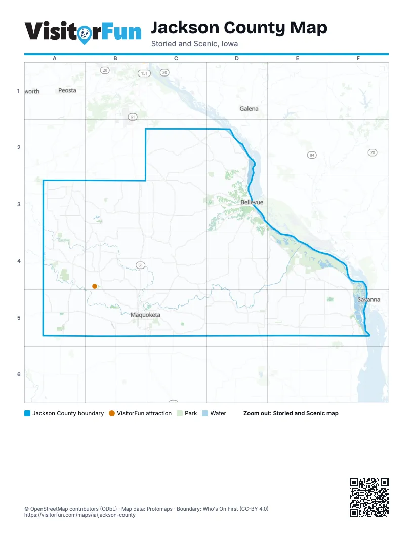
Maps inside Jackson County
1 map inside, from the street map of Jackson County down.
Street index of Jackson County
Each street on the sheet and the grid squares it crosses.
- State Highway 64A5, B5, C5, D5, E5, F5
- Great River RoadC2, D2, D3, E3, E4, F4, F5
- Ansel Briggs HighwayC3, D3, C4, C5
- North Riverview StreetD3
- State StreetD3
- East Platt StreetB5, C5
- Broad StreetF5
- West Platt StreetB5
- West Main StreetA5, D5
- Sycamore StreetF5
- East Main StreetA5, D5
- West White StreetD5
- South Riverview StreetD3
- Main StreetC2, B3
- East White StreetD5, E5
- Dale Gardner Veterans Memorial BridgeF5
- North Jefferson StreetC4
- South Jefferson StreetC4
- Railroad StreetA5
- Bellevue RoadF5
- 150th StreetA4, B4, C4, D4, E4
- Bellevue-Cascade RoadA3, B3, C3, D3
- Bernard RoadA3, A4, B4
- 435th AvenueD4, E4, D5, E5
- 50th AvenueA4, A5
- Iron Bridge RoadC4, C5, D5
- 250th AvenueC3, C4
- 500th AvenueE4, E5
- 320th StreetC2, D2, C3, D3
- 400th AvenueD3, D4, D5
- Caves RoadB4, B5
- 230th AvenueB2, C2, C3
- 17th AvenueA5
- West Bellevue-Cascade RoadA3
- 200th AvenueB4, C4, B5, C5
- 300th StreetB3, C3, D3
- 418th AvenueD5
- Washington Mills RoadB3
- North Main StreetC3, C4, B5, D5
- Hurstville RoadB5
- South Main StreetC3, C4, B5, D5
- 55th StreetB4, B5
- 142nd AvenueB5
- Ferry RoadE5
- 163rd StreetA4
- West Summit StreetB5
- Union StreetB3, C3, F5
- East Summit StreetB5, C5
- North Division StreetA5, D5
- Oak StreetB3, C3, D3
- Elm StreetB3, C3, D3
- 254th AvenueC5
- South Division StreetA5, D5
- Jacobsen DriveC5
- West MainD4
- 252nd AvenueC2, C5
- Pleasant StreetC3, A5
- Skyline RoadC2
- East Calhoun StreetC4
- East MainD4
- Water StreetC3
- West Calhoun StreetC4
- Olde Davenport RoadB2
- 216th AvenueC3, B4, C4
- Mill Creek RoadC3, D3
- 17th StreetB5, C5, D5, E5, F5
- 33rd StreetA5, B5, C5, D5, E5
- 100th StreetB4, C4, D4, A5, B5, C5, D5, E5, F5
- 407th AvenueD3, D4
- 362nd AvenueD3, D4
- 317th AvenueC4, D4, C5
- Centerville RoadC2
- 45th StreetD5, E5
- South Garryowen RoadA3, B3, B4
- 21st AvenueA3, A4
- 35th StreetB5, C5
- Esgate RoadB4, B5
- 267th StreetA3, B3, C3
- 550th AvenueE4, E5
- 475th AvenueE4, E5, F5
- Green Island RoadE4
- 283rd StreetB3, C3
- 380th AvenueD2
- 584th AvenueF5
- 13th StreetA5, B5, C5
- 113th AvenueB3, B4
- Rockdale RoadB5, C5
- 387th StreetD4, D5
- 109th AvenueB4
- 75th StreetC5, E5
- 154th AvenueB3
- High Bridge RoadC2, D2
- 387th AvenueD2, D4, D5
- 208th StreetB3
- 395th AvenueD2, D3
- 188th StreetB4, D4
- 108th StreetB4
- 166th StreetA4
- 145th AvenueB3, B4
- 21st StreetD5, E5, F5
- 234th StreetA3
- 162nd StreetA4, B4
- 7th AvenueA3
- 140th AvenueB3
- 45th AvenueA4
- 458th AvenueE5
- 180th StreetC4
- 46th AvenueA3
- 20th AvenueA3, A5
- 53rd StreetC5, D5
- 199th AvenueB4, C4
- 16th StreetB5, D5
- 613th AvenueF5
- 194th AvenueB3
- 150th AvenueB4
- 67th StreetA5, E5
- 86th AvenueB3, B4
- North 2nd StreetD3, B5
- 217th StreetB3
- 112th StreetD4
- Pershing RoadB5, C5
- East Maple StreetB5, C5
- North 7th StreetD3
- 9th AvenueA3
- 211th AvenueC5
- 250th StreetA3
- 225th StreetA3
- Park StreetD3
- 244th StreetA3
- Section RoadE5
- 385th StreetD2
- 334th AvenueD5
- East Quarry StreetB5, C5
- South Vermont StreetB5
- 461st AvenueE5
- West School StreetD5
- 63rd StreetB5, D5
- 232nd StreetC4
- South Matteson StreetC5
- North Walnut StreetC5
- 1st Street NorthD4
- Western AvenueB5
- Hospital DriveB5, C5
- West Quarry StreetB5
- 343rd AvenueD2
- West 1st StreetC2
- East 1st StreetC2
- 1st Street SouthD4
- North Vermont StreetB5
- Anderson StreetC5
- Curoe RoadA3
- Skahill RoadA4
- 216th StreetC3, D3
- Sieverding Ridge RoadC2, C3, D3
- 167th StreetB4, C4, D4, E4
- 12th StreetC5, D5
- 82nd AvenueA4, B4, A5, B5
- 64th StreetE5, F5
- 274th StreetC3
- 308th StreetC2, D2, D3
- 58th StreetD5, E5
- 92nd StreetA4, C4, A5
- 525th AvenueE5
- Dark Hollow RoadC4, C5
- 83rd StreetA5, E5, F5
- 175th StreetB4, C4
- 341st AvenueD3, D4
- 85th StreetB5
- 258th StreetC3
- 258th AvenueC2, C3, C5
- 233rd AvenueC4, C5
- 296th AvenueC2, C5
- 495th AvenueE4, E5
- 30th AvenueA4
- 182nd AvenueB3, B4, B5
- 288th AvenueC4, C5
- 370th StreetC2, D2
- 50th StreetA5, E5, F5
- 114th StreetC4, D4, E4
- 328th AvenueD3, D4
- 300th AvenueC3, C4, C5
- 374th AvenueD4
- 167th AvenueB3, B4
- 298th AvenueC4
- 200th StreetC4
- 74th StreetB5
- 239th AvenueC2
- 450th AvenueE4, E5
- 413th AvenueD4, E4
- 484th AvenueE4, E5
- 189th StreetC4
- 117th StreetC4
- 287th StreetB3, C3
- Leisure Lake RoadB3
- 375th AvenueD3, D4
- 109th StreetA4, D4
- 389th StreetC2
- 174th AvenueB5
- 161st StreetE4
- 42nd StreetC5, D5
- 607th AvenueF5
- 100th AvenueB5
- 224th StreetA3
- 136th StreetB4
- 134th StreetB4, C4
- 98th StreetB4
- 317th StreetC2
- 91st StreetB4, C4, B5
- 80th StreetA5, B5
- 159th AvenueB3, B4
- 82nd StreetD4, D5
- 60th AvenueA4
- 124th StreetD4
- 383rd AvenueD3, D5
- 226th StreetB3
- 297th AvenueC3, C4
- 123rd AvenueB4, B5
- 195th StreetD3, D4
- 261st AvenueC4
- 142nd StreetE4
- 67th AvenueA5
- 253rd AvenueC2
- 53rd AvenueA5
- 134th AvenueB5
- 90th StreetB4, B5
- 65th AvenueA5
- 80th AvenueA5
- 540th AvenueE4, E5
- 254th StreetB3
- 275th StreetB3
- 110th StreetB4, C4
- 10th AvenueA5
- 125th AvenueB5
- 308th AvenueC4, D5
- 155th AvenueB4
- 138th AvenueB5
- 454th AvenueE4, E5
- 168th AvenueB4, B5
- 24th StreetB5, C5
- 615th AvenueF5
- 183rd AvenueB3
- 7th StreetB5
- 234th AvenueC4
- 345th AvenueD4, D5
- 70th StreetB5, D5
- 333rd AvenueD2
- 81st StreetC5
- 287th AvenueC4, C5
- 429th AvenueD3, D4
- 248th AvenueC2
- 184th StreetC4
- 184th AvenueB3, B5
- 386th AvenueD2
- 79th StreetD5, E5
- 283rd AvenueC3
- 94th AvenueB4
- 384th StreetB2, C2
- 559th AvenueF5
- South 2nd StreetD3, B5
- 22nd StreetA5, B5, C5
- 19th AvenueA4
- 69th StreetB5
- 130th StreetD4
- 232nd AvenueC2, C4
- 172nd AvenueB5
- 330th StreetC2
- 360th AvenueD4
- Smiths Ferry RoadD2
- 282nd StreetC3
- Lake Shore DriveB3
- 37th StreetB5
- McDevitt LaneA3
- 133rd StreetE4
- 6th AvenueA4
- 366th AvenueD5
- South 5th StreetD3, B5
- 169th AvenueB3
- 171st AvenueB4
- 501st AvenueE4
- 185th StreetA4
- 111th StreetD4
- 212th AvenueC4
- 193rd StreetD4, E4
- 371st AvenueD5
- 576th AvenueF4
- 398th AvenueD3, D4
- 335th StreetD2
- Washington StreetD3, A5, B5, E5, F5
- 159th StreetB4
- 129th AvenueB3
- 364th AvenueD5
- 127th AvenueB3
- 256th AvenueC4
- 12th AvenueA5
- 346th AvenueD2
- 206th StreetA3
- 40th AvenueA4
- 1st AvenueA3, D5
- 558th AvenueF4
- 373rd AvenueD4
Things to do on the Jackson County map
Places on the map
- Andrew
- Baldwin
- Bard Materials
- Bellevue
- Bellevue State Park
- Bellevue Township
- Big Soup Bone Island
- Blackhawk Wildlife Area
- Bonnie Lake
- Bowman Island
- Brandon Township
- Butler Township
- Buzzard Ridge Wildlife Area
- Densmore Lake
- Eden Valley Refuge
- Fairfield Township
- Farmers Creek Township
- Fish Lake
- Flat Lake
- Green Island Wildlife Management Area
- IHAP - Jackson County 2
- IHAP Jackson 1
- Jackson County Recreation Trail
- Jackson Lake
- Jackson Township
- La Motte
- Leisure Lake
- Little Soup Bone Island
- Lower Sabula Lake
- Maquoketa
- Maquoketa Caves State Park
- Maquoketa River
- Maquoketa Township
- McNeil Nature Preserve
- Middle Sabula Lake
- Miles
- Monmouth
- Monmouth Township
- Otter Creek Township
- Ozark Wildlife Area
Next to Jackson County
- Epworth
- Galena
- Peosta
- Savanna
© OpenStreetMap contributors, Open Database License, openstreetmap.org/copyright · Map data: Protomaps · Boundary: Who's On First (CC-BY 4.0); Quattroshapes (CC BY 2.0)