

Idaho map
Pocatello map
About 58,231 people live here (Census Bureau, 2024 estimate). The sheet's index lists 300 streets; Veterans Memorial Highway, Eastpointe Drive and South 5th Avenue cross the most grid squares. Also on it: Highland Golf Course, Juniper Hills Country Club and Portneuf Medical Center.
Open the map (PDF, US Letter)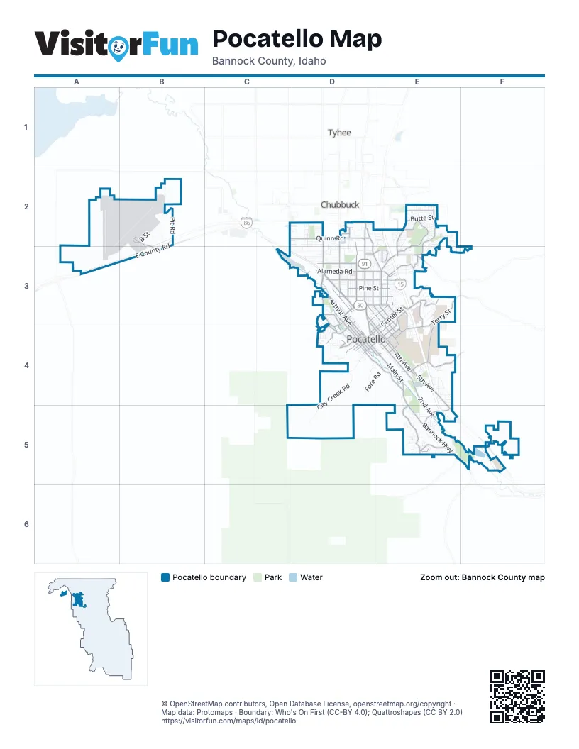
Street index of Pocatello
Each street on the sheet and the grid squares it crosses.
- Veterans Memorial HighwayE2, E3, E4, E5, F5
- South 5th AvenueE4, E5, F5
- Garrett WayD3
- Yellowstone AvenueD2, D3
- South 4th AvenueD3, D4, E4
- West Quinn RoadD2
- Pocatello Creek RoadE3
- West Alameda RoadD3
- East Alameda RoadD3, E3
- Pocatello AvenueD3, D4
- Gould StreetD3
- East Gould StreetD3
- North 5th AvenueD3, E4
- YellowstoneD3
- North 4th AvenueD3
- Bannock HighwayE4, E5, F5
- North Main StreetD3, D4
- East Center StreetE3, D4, E4
- Pole Line RoadD2, D3
- North Arthur AvenueD3, D4
- South Main StreetD4, E4
- Hiline RoadD2, D3, E3
- East Clark StreetE3, D4, E4
- East Benton StreetE3, E4
- Hawthorne RoadD2, D3
- Olympus DriveE2, E3
- Jefferson AvenueE3
- South Valley RoadE5
- East Oak StreetD3, E3
- South Arthur AvenueD4, E4
- West Gould StreetD3
- West Benton StreetD4, E4
- Flandro DriveD2
- West Putnam StreetE4
- Madison AvenueD3
- West Pocatello Creek RoadE3
- Pole Lline RoadD3
- South 2nd AvenueD4, E4, E5
- East Terry StreetE3, E4
- Satterfield DriveE2, E3
- McKinley AvenueD2, D3
- South Grant AvenueD4, E4
- Johnny Creek RoadE5
- Barton RoadE4
- East County RoadB2, B3
- North Hayes AvenueD3, D4
- Terminal WayB2, B3
- Alvin Ricken DriveE3, E4
- South Fairway DriveE2, E3
- Country Club DriveE5
- West Eldredge RoadD3
- West Cedar StreetD3
- Foothill BoulevardD3, D4
- East Bonneville StreetE3, D4, E4
- Monte Vista DriveE3
- North Garfield AvenueD3, D4
- Fairway DriveE2
- Washington AvenueD3
- North 1st AvenueD3, D4
- Highland BoulevardD4
- Vista DriveE3
- Butte StreetE2
- East Carter StreetE4
- West Clark StreetD4
- El Rancho BoulevardD3, E3
- West Fremont StreetD4
- East Poplar StreetD3, E3
- East Maple StreetD3, E3
- Jerome StreetE2
- East Cedar StreetD3, E3
- Hospital WayE3, E4
- Franklin AvenueE3
- West Maple StreetD3
- South 8th AvenueE3, E4
- East Pine StreetD3, E3
- North 8th AvenueD3, E3
- East Hayden StreetD3, E3
- South 19th AvenueE3, E4
- North 10th AvenueD3, E3
- Moreland AvenueD3
- Riverside DriveD3, D4
- West Custer StreetD3, D4
- West Center StreetD4
- Memorial DriveE3, E4
- Skyline DriveD4
- North 12th AvenueE3
- Gwen DriveD4
- West Pine StreetD3
- South Hayes AvenueD4
- West Lewis StreetD4
- Booth DriveE3
- South 10th AvenueE3, E4
- West Carson StreetD3
- East Humbolt StreetE4
- Hurley DriveD2
- Santa Anita AvenueE3
- North 15th AvenueE3
- South Garfield AvenueD4
- Huntington DriveE5
- North 2nd AvenueD3, D4
- South 12th AvenueE3, E4
- Oakwood DriveD3
- North Gathe DriveD3
- Fredregill RoadE4
- North Union Pacific AvenueD4
- Martin Luther King Jr WayE4
- Kraft RoadD3
- Pearl StreetD3
- Bullock StreetD2
- Trail Creek RoadD3, D4
- South Union Pacific AvenueD4
- East Quinn RoadD2
- Fairground DriveE2
- West Buckskin RoadE3
- North Old Highway 91E5
- North 19th AvenueE3
- South 15th AvenueE3
- City Creek RoadD4, D5
- North Harrison AvenueD3, D4
- Fore RoadD4, E4
- Willard AvenueD3
- South 1st AvenueD4, E4
- American RoadE3, E4
- Wayne AvenueE3
- Wilson AvenueD3
- Bartz DriveE4
- Bench RoadE2, E3
- South 3rd AvenueE4
- Government RoadB2
- East Lander StreetE3, D4, E4
- Pershing AvenueD3
- Park AvenueE3
- East Elm StreetD3, E3
- Randolph AvenueE3
- Cottage AvenueD3
- Summit DriveE2
- East Lewis StreetE3, D4, E4
- East Wyeth StreetD3, E3
- Stockman RoadE4
- North Grant AvenueD3, D4
- East Fremont StreetD3, E3
- South 7th AvenueE4
- Cove RoadD4
- Kinghorn RoadD2
- Pit RoadB2
- Hyde AvenueE3
- Taghee RoadB2
- Dolostone DriveD2
- Hancock DriveE4
- East Whitman StreetE3, E4
- Roosevelt AvenueD3
- Boeing AvenueB2
- Warren AvenueD3
- East Walnut StreetD3, E3
- Birdie Thompson DriveE3
- Beechcraft AvenueB2, B3
- Filmore AvenueE3
- Henderson LaneD2, D3
- Valleyview DriveD4
- Cedar StreetE3
- B StreetB2
- North 9th AvenueD3, E3
- North 7th AvenueD3, E3, E4
- East Bridger StreetD3, E3
- South Lincoln AvenueD4
- Canyon DriveD4
- Ada StreetE2
- East Halliday StreetE4
- Richland AvenueD3
- Diane LaneE2
- Thunderbolt StreetB2
- Redhill RoadE4
- Shoshone AvenueD3, D4
- Cedar Hills DriveE5
- Douglas StreetE2
- North 11th AvenueE3
- North Lincoln AvenueD4
- Avenue of the ChiefsE4
- Fairmont AvenueE3
- Appaloosa AvenueE2
- Jensen StreetD3
- West Sublette StreetD3, D4
- South 9th AvenueE3, E4
- East Sublette StreetD3, E3
- Ore Ida CourtD2
- Marinus LaneE2
- West Wyeth StreetD4
- Horizon DriveE3
- Zener StreetD3
- Jason AvenueE4
- Swisher RoadE4
- Michelle StreetE2, E3
- Stoneridge DriveE2, E3
- Taft AvenueD3
- Mohawk StreetE5
- West Bridger StreetD4
- Rocky Point RoadD4
- Cliffs DriveE4
- West Young StreetD3, D4
- Ducey StreetD2, D3
- Mooney AvenueB2, B3
- Wildlife WayE4
- West Hayden StreetD4
- North 13th AvenueE3
- West Lander StreetD4
- Via ValdarnoE3
- Bryan RoadD3
- Ardella DriveE3
- Eastpointe DriveD2, E2, D3, E3
- Tech Farm RoadE4, E5
- Cahina WayE5
- University DriveE3, E4
- North Johnson AvenueD4
- Sam Nixon DriveE4
- Aspen LaneD3
- Beth StreetE3
- Hiskey StreetE2
- West Whitman StreetD4
- Slate Mountain DriveE3
- Cheyenne AvenueE5
- Ridge StreetD3
- La Montagna StreetE3
- West Bonneville StreetD4
- Shadowpines WayE2, E3
- McCaleb DriveE2
- Troy LaneD2
- East Dillon StreetE4
- Golden Gate StreetE2
- North 6th AvenueD3, E3, E4
- North 14th AvenueE3
- Ammon StreetE3
- Clearwater StreetE2
- Syringa StreetE3
- Dartagnan DriveE4
- Juniper DriveE5
- South 11th AvenueE3, E4
- Lavine DriveE3
- Ethans WayE5
- Wingate DriveD2, D3
- Bell RoadB2
- West Halliday StreetD4, E4
- Brock DriveD2, D3
- Magellan LoopD3, D4
- Meadowbrook LaneD3, E3
- Steven StreetE2
- Sandpiper DriveD2, D3
- Jean StreetE3
- Poole AvenueD3
- Blandy StreetD2, D3
- La Valle StradaE3
- West Greeley StreetD3, D4
- Sunny Brook DriveD2
- West Day StreetD3
- East Lovejoy StreetE4
- Granite DriveE2
- Juniper Hill RoadE5
- Pond PlaceE5
- Northgate DriveD2
- Baldy AvenueE2
- Holman AvenueE3
- Hussey StreetD3
- North Buchanan AvenueD4
- Arlington DriveE5
- Daisy LaneE5
- West Trail Creek RoadD3, D4
- Packard AvenueD3
- Kim DriveE5
- Park LaneE2, E3
- Restlawn DriveE4
- Toponce StreetD4
- Nora AvenueE4
- South 6th AvenueE4
- South Johnson AvenueD4
- Gail DriveE3
- Delphic WayE2
- Saratoga StreetE2
- Lois LaneE2
- North 3rd AvenueD3, D4, E4
- Ruddock StreetD2, D3
- Plateau DriveD4
- Foxmore StreetE5
- East Sherman StreetD3, E3
- Balboa RoadD3, D4
- Sunrise WayE2
- Samuel StreetE4
- South Harrison AvenueE4
- Bullard StreetD3
- West Sherman StreetD3, D4
- Cesna RoadB2
- Patsy DriveE3
- Old Ranch RoadE5
- West Poplar StreetD3
- Driftwood StreetD3
- East Chapel RoadD3, E3
- Night Hawk WayE4
- Frontage RoadB2
- Elmore StreetE2
- Homer DriveE3
- Drake AvenueE4
- Running Iron LaneF5
Places on the map
- Alameda Center
- Ammon Park
- Bartz Field
- Centennial Park
- Century High School
- Clarion Inn Pocatello
- Cole Chevrolet
- Constitution Park
- Davis Field
- Edahow Elementary
- Franklin Junior High
- Gate City Elementary School
- Haliwell Park
- Hawthorne Middle School
- Hawthorne Park
- Highland Golf Course
- Highland High School
- Hirning Buick/GMC
- Idaho State University
- Indian Hills Elementary
- Indian Hills Soccer Complex
- Irving Middle School
- Irving Middle School Track
- Jefferson Elementary School
- Juniper Hills Country Club
- Lower Ross Park
- Lythia Chrysler/Jeep/Dodge
- Memorial Park
- Mountain View Cemetery
- N.O.P. Park
- O.K. Ward Park
- Pocatello High School
- Pocatello Regional Airport
- Pocatello Trap Club
- Pocatello Women's Correctional Center
- Portneuf Medical Center
- Raymond Park
- Riverside Golf Course
- Sacajawea Park
- Sister City Park
Next to Pocatello
- Chubbuck map
- Tyhee
© OpenStreetMap contributors, Open Database License, openstreetmap.org/copyright · Map data: Protomaps · Boundary: Who's On First (CC-BY 4.0); Quattroshapes (CC BY 2.0)















