

Idaho map
Blaine County map
About 25,261 people live here (Census Bureau, 2024 estimate). The sheet's index lists 300 streets; Idaho Medal of Honor Highway, National Forest Development Road 097 and Main Street cross the most grid squares. Things to do inside the boundary: Sun Valley Resort, Boulder Mountain Clayworks and Ryan's Mountain Rentals.
Open the map (PDF, US Letter)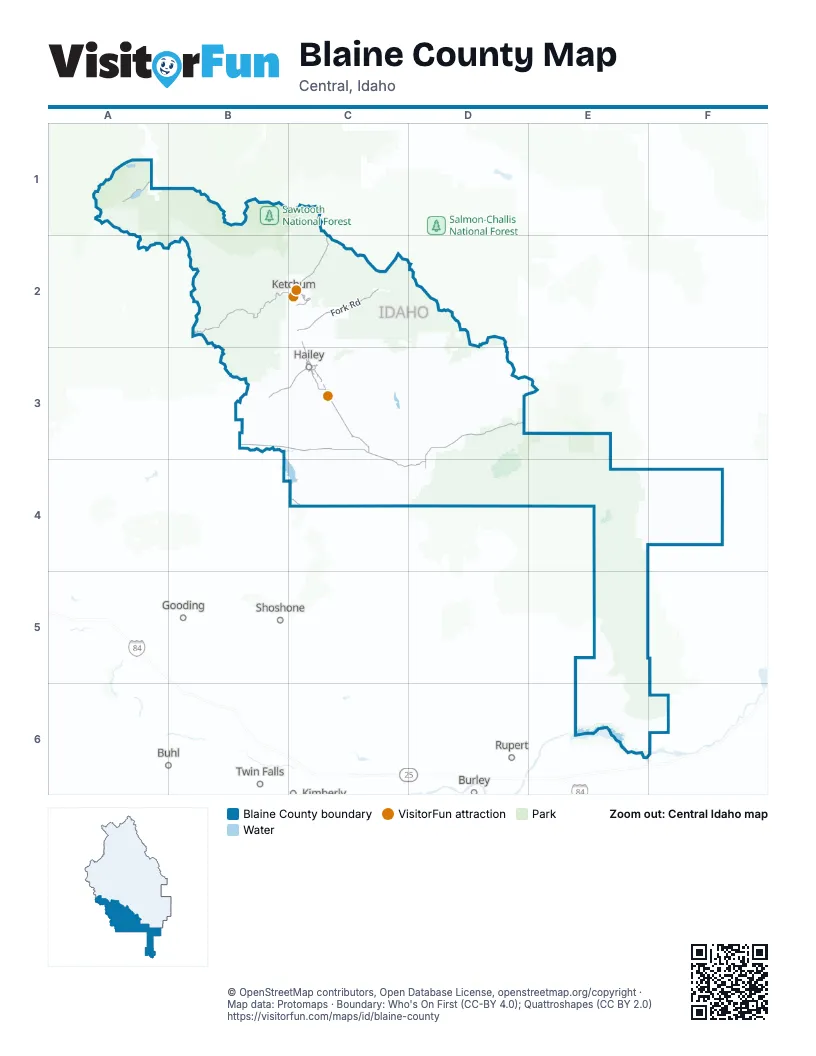
Street index of Blaine County
Each street on the sheet and the grid squares it crosses.
- Idaho Medal of Honor HighwayB3, C3, D3, C4, D4
- East Fork RoadC2
- Main StreetC3, D3, D4
- North Main StreetC2, D3
- South Main StreetC2, C3
- Queens Crown RoadD4
- Main Street NorthC3
- Elkhorn RoadC2
- Warm Springs RoadB2, C2
- East Sun Valley RoadC2
- Saddle RoadC2
- Dollar RoadC2
- Warm Springs Creek RoadB2
- Trail Creek RoadC1, C2
- Croy Creek RoadB3, C3
- Gannett Picabo RoadC3
- West Warm Springs RoadB2
- Alturas Creek RoadA1
- Broadford RoadC3
- Gannett RoadC3
- Buttercup RoadC2, C3
- Cottonwoods RoadC4
- Woodside BoulevardC3
- Sun Valley RoadC2
- Morning Star RoadC2
- North 2nd AvenueC2, C3
- Fox Acres RoadC3
- North 3rd AvenueC2, C3
- Cedar StreetC3
- South 3rd AvenueC2, C3
- River StreetC3
- 2nd Avenue NorthC3
- Village WayC2
- Aviation DriveC3
- Quigley Farm RoadC3
- South 2nd AvenueC2, C3
- East Croy StreetC3
- South River StreetC3
- McKercher BoulevardC3
- West Magic RoadB4, C4
- East Bullion StreetC3
- South 4th AvenueC2, C3
- East Myrtle StreetC3
- East Elm StreetC3
- Quigley RoadC3
- 5th Avenue NorthC3
- Airport WayC3
- Croy StreetC3
- West 8th StreetC2
- 2nd Avenue SouthC2, C3
- Countryside BoulevardC3
- East 10th StreetC2
- Lower Ranch Condo DriveC2
- Serenade LaneC2
- West Bullion StreetC3
- Bullion StreetC3
- 4th AvenueC3
- 4th Avenue SouthC3
- 8th AvenueC3
- West Sun Valley RoadC2
- East 8th StreetC2
- Picabo Desert RoadC4
- Flat Top RoadC3, D3
- Fish Creek RoadD3
- Rock Creek RoadB3, C3
- Baker Creek RoadB2
- Glendale RoadC3
- Little Fish Creek RoadD3
- Little Wood Reservoir RoadD3
- Cutoff RoadC4, D4
- Spud Patch RoadC3, C4
- Austin RoadD3
- Quigley Canyon RoadC3
- Fish Creek Reservoir RoadD3
- Muldoon Canyon RoadC3, D3
- North Picabo RoadC3, C4
- Baseline RoadC3
- East Magic RoadC4
- East Fork Fish Creek RoadD3
- Priest RoadC4, D4
- West Fork Fish Creek RoadD3
- National Forest Development Road 097B2, C2, B3, C3
- East Minidoka RoadE6
- Picabo Hills RoadC4
- Hyndman Creek RoadC2
- National Forest Development Road 137C2
- Dry Creek RoadC3, D3
- Kingsbury LaneC3
- Salmon River RoadA1, B1
- Pole Creek RoadB1
- Bradley Hill RoadC3
- North Laidlaw Park RoadD3
- Greenhorn RoadB2, C2
- Indian Creek RoadC2, C3
- Cabin Creek RoadA1
- Townsend Gulch RoadC3
- Pettit Lake RoadA1
- South Picabo LaneC3
- Valley Club DriveC2, C3
- Barton RoadD3
- Orten Ranch RoadE6
- Kilpatrick Bridge RoadC3
- Prairie Creek RoadB2
- Price LaneC3
- Ohio Gulch RoadC2
- North Refuge RoadE6
- Griffin LoopD4
- Schoessler LaneC3
- Pero RoadC3
- East Muldoon Creek RoadD2
- 1000 East RoadE6
- Arco RoadE6
- National Forest Development Road 194A1, B1
- Poverty Flat RoadB3, C3
- Mormon Hill RoadD2
- Punkin Center RoadC3
- Main Line Ranch RoadE6
- Friedman LaneC3
- Croesus Gulch RoadC3
- National Forest Development Road 267C2
- Lava Lake RoadD3
- Triumph Gulch RoadC2
- Robert StreetC4
- Miller RoadE6
- Bay Horse RoadC3
- Aspen Lakes DriveC3
- Valley RoadA1, B1
- Juniper RoadC2
- Valley View Loop RoadA1
- Stalker Creek RoadC3
- Independence Creek RoadC2
- Browning LaneC3
- Mecham LaneC3, D3
- Durfee LaneD3, D4
- Freedom LoopC3
- Glenbrook DriveC3
- East Glendale RoadC3
- Yale RoadE6
- Sluder DriveC3
- Peck RoadD3
- Fairway RoadC2
- Durfee RoadC4, D4
- Hyndman View DriveC2
- Hillside Ranch RoadC3
- Norton Creek RoadB2
- Lane Ranch RoadC2
- Cenarrusa LaneD4
- Owyhee Farms Ranch RoadE6
- Quadrant Gulch RoadB2
- Pioneer View DriveB3, C3
- Old State HighwayC4
- Canyon RoadC2
- Spruce Creek RoadB2
- Golden Eagle DriveC2
- Lower Broadford RoadC3
- North Fork Canyon RoadB2
- Red Devil DriveC3
- Gimlet RoadC2
- Camp Creek RoadB3
- Winterhaven DriveC3
- Chestnut StreetC3
- First StreetC4
- Hunsinger RoadE6
- Equus LoopC3
- Valley View RoadA1
- 4th StreetC3, D3, B4
- Wall StreetC2
- View DriveC3
- Big Butte Springfield RoadF4
- Hot Springs Landing RoadB3
- Split Butte RoadE6
- Broadway Run RoadC2
- Wood River DriveC2
- Teal DriveC2
- Walnut StreetC3
- Owl Rock RoadC2
- Willow RoadC2
- 5th StreetC3, B4
- Prairie Sun RoadC3
- Reay LaneD3
- Adams Gulch RoadB2, C2
- Hunt LaneD3
- Shenandoah DriveC3
- National Forest Development Road 134D2
- Cold Springs Gulch RoadC2
- Meadowbrook RoadC2
- Dam RoadC4
- 2nd StreetC3, B4
- Gardner LaneC3
- Apache DriveC2, C3
- East Gulch RoadC2
- 3rd StreetC3, B4
- Minidoka To Arco RoadF4
- Fish CreekD3
- Karst DriveC2
- Silverwood DriveC3
- Aspen DriveB2, C3
- Laurelwood DriveC3
- Bigwood DriveC2
- Eagle Creek RoadB2
- Griffin Ranch RoadC3
- 6th StreetC3
- Barlow RoadB2
- Mountain View DriveD3
- Harriman Trail Access RoadB2
- Rodeo DriveC3
- North Hiawatha DriveC3
- Lake Creek DriveB2, C2
- Lava LaneD4
- Northwood WayC2
- Six Star RoadC3
- Irwin Ranch RoadE6
- Wilderness DriveC2
- Shaun LaneC2
- River Ranch RoadC2, E6
- Canyon Run BoulevardC2
- County Line RoadB3
- Weyyakin DriveC2
- Cove Ranch RoadC3
- Eastridge DriveC3
- Stonegate CircleB2
- South 1st AvenueC2, C3
- 7th StreetC3
- Greenhorn Gulch RoadB2, C2
- Labador LaneC3
- Lake View DriveD3
- Bitterroot RoadC2
- Meadow CircleC2
- Calypso LaneC3
- Sweet Brier RoadC2
- Skyline DriveA1, C2
- Northridge DriveC3
- San Badger DriveC3
- CD Olena DriveC3
- Baldy View DriveC3
- Hillside RanchC3
- Clubhouse DriveC2
- Elm StreetC3
- Timber WayC2
- Stone Bridges RoadC2
- North 4th AvenueC2, C3
- Golden Currant DriveC3
- Colorado Gulch RoadC3
- Silver Star DriveC3
- Bullion Gulch RoadB3, C3
- Vader DriveA1
- Crazy Horse DriveC2
- North 1st AvenueC2, C3
- Carey AvenueD3
- Hayspur LaneC3
- Dip Creek RoadB2
- Rock Creek AccessB3
- Sunset LaneD4
- Broadway BoulevardC2
- Fox Hollow Gulch RoadC3
- South Hiawatha DriveC3
- Foothill LaneD3
- Buckhorn DriveC3
- North Easley Hot Springs RoadB2
- Sunrise DriveC2, C3
- Tendoy StreetC3
- Logans LaneC3
- Diamond Back RoadC2
- Paintbrush LaneB2
- Heroic RoadC3
- Oak StreetC3
- Baker Creek LoopB2
- Sun Peak DriveC2
- Berrycreek DriveC3
- Spur LaneC2
- Leadville AvenueC2
- Starweather DriveC2
- Timberline RoadC2
- Bald Mountain RoadB2
- Lake Creek Meadows RoadC2
- Grace DriveC3
- Mother Lode LoopC3
- West Meadow DriveC3
- Willoway RoadC2
- Galena StreetC3
- Fairway Nine DriveC2
- Wood River Campground RoadB2
- Molyneux Cutoff RoadC3
- Prospector RoadB2, C2
- Sitting Bull DriveC2
- West Sage RoadB2, C2
- Angela DriveC3
- Poplar StreetC3
- Glen Aspen DriveC3
- Little Wood DamC3
- Pine StreetC3
- Quarter Horse DriveC3
- Queen of the Hills DriveC3
- Sage RoadB2
- Pete's LaneC2
- Crown Ranch RoadC2
- Noe WayC3
- Cranbrook RoadC3
- Abes Chair RoadA1
- Camp Stanley RoadA1
Things to do on the Blaine County map
Places on the map
- Advanced Loop
- Alice Lake
- Alturas Inlet Campground
- Alturas Lake
- Atkinson Park
- Baker Creek Camping Area
- BCRD Quigley Trails Park
- Bear Park
- Bellevue
- Bigwood Golf Course
- Billy's Bridge Camping Area
- Carey
- Carey Lake
- Craters of the Moon Lava Flow
- Draper Nature Preserve
- Easley Campground
- Elkhorn Golf Course
- Fish Creek Reservoir
- Friedman Creek Wilderness Study Area
- Hailey
- Ketchum
- Lava Lake
- Little Park
- Little Wood River Reservoir
- Little Wood River Wilderness Study Area
- Magic Reservoir
- Mill Lake
- Miner Lake
- North Shore Campground
- Paddleford Flat
- Perkins Lake
- Pettit Lake
- Sawtooth National Forest
- Silver Creek Preserve
- Sun Valley
- Sun Valley - Bald Mountain
- Sun Valley - Dollar Mountain
- Trail Creek Golf Course
- Wapi Lava Flow
- White Cloud Nine at Sun Valley
Next to Blaine County
- Buhl
- Burley
- Gooding
- Kimberly
- Rupert
- Shoshone
- Twin Falls map
© OpenStreetMap contributors, Open Database License, openstreetmap.org/copyright · Map data: Protomaps · Boundary: Who's On First (CC-BY 4.0); Quattroshapes (CC BY 2.0)















