

Idaho map
Boise map
About 237,963 people live here (Census Bureau, 2024 estimate). The sheet's index lists 228 streets; Vietnam Veterans Memorial Highway, East Warm Springs Avenue and South Federal Way cross the most grid squares. Things to do inside the boundary: Boise Museums, Boise River Greenbelt and Idaho State Capitol.
Open the map (PDF, US Letter)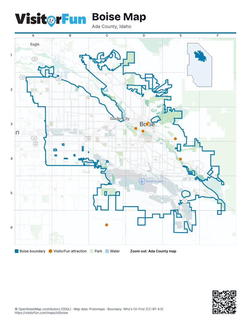
Street index of Boise
Each street on the sheet and the grid squares it crosses.
- West Hill Road ParkwayB1
- North Collister DriveC1, C2
- North Gary LaneC1
- North Glenwood StreetC1, C2
- North Pierce Park LaneC1, C2
- West Hill RoadC1, C2, D2
- West State StreetC1, C2, D3
- North Cartwright RoadD1, D2
- East Chinden BoulevardA2
- East Colchester DriveA2
- East McMillan RoadA2
- North Bennington WayA2
- North Cloverdale RoadA2, A3
- North Discovery WayA2
- North Eagle RoadA2
- North Meeker AvenueA2
- North Meeker PlaceA2
- North Park Meadow WayA2
- South Eagle RoadA2
- West Ashcreek StreetA2
- West Bridger StreetA2
- West Bristol Heights DriveA2
- West Chinden BoulevardA2, B2, C3
- West Edna StreetA2, B2
- West Explorer DriveA2
- West Hobble Creek DriveA2
- West Lasalle StreetA2
- West McMillan RoadA2, B2
- North Five Mile RoadB2, B3
- North Jullion WayB2
- North Maple Grove RoadB2, B3
- North Milwaukee StreetB2, B3
- North Mitchell StreetB2, B3
- North Mountain View DriveB2, C2
- North Wildwood StreetB2, B3
- West Goddard RoadB2, C2
- West Ustick RoadB2, C2
- North 36th StreetC2, D2
- North Cole RoadC2, C3
- North Johns Landing WayC2
- North Veterans Memorial ParkwayC2
- West Bloom StreetC2
- West Castle DriveC2
- West Catalpa DriveC2
- North 13th StreetD2, D3
- North 15th StreetD2, D3
- North 28th StreetD2, D3
- North 8th StreetD2, D3
- North Bogus Basin RoadD2
- North Harrison BoulevardD2, D3
- North Whitewater Park BoulevardD2, C3, D3
- East Fairview AvenueA3
- East Granger AvenueA3
- South Cloverdale RoadA3, A4
- West Executive DriveA3, B3
- West Fairview AvenueA3, B3, C3, D3
- West Granger AvenueA3, B3
- West Sunnydale LaneA3, B3
- Boise ConnectorB3, C3, D3, B4
- North Benjamin LaneB3
- North Dawn DriveB3
- North Hampton AvenueB3
- North Hampton RoadB3
- North Kimball StreetB3
- North Meadowland DriveB3
- North Shamrock AvenueB3
- North Shamrock StreetB3
- North Steelhead WayB3
- South Benjamin LaneB3
- South Five Mile RoadB3, B4
- South Maple Grove RoadB3, B4
- West Cory LaneB3
- West Emerald StreetB3, C3, D3
- West Franklin RoadB3, C3
- West Irving StreetB3, C3
- West Northview StreetB3, C3
- West President DriveB3
- West Rifleman StreetB3
- West Sunflower LaneB3
- West Westpark StreetB3
- North Allumbaugh StreetC3
- North Curtis RoadC3
- North Orchard StreetC3
- North Phillippi StreetC3
- North Roosevelt StreetC3
- South Allumbaugh StreetC3
- South Allumbaugh WayC3, C4
- South Cole RoadC3, C4
- South Curtis RoadC3, C4
- South Orchard StreetC3, C4, C5
- South Phillippi StreetC3, C4
- South Roosevelt StreetC3, C4
- West Barrister DriveC3
- West Main StreetC3, D3
- West Rose Hill StreetC3, D3
- East Fort StreetD3
- East Front StreetD3
- East Idaho StreetD3
- East Jefferson StreetD3
- East Myrtle StreetD3
- East Park BoulevardD3
- East Parkcenter BoulevardD3, D4, E4, F4
- East Reserve StreetD3
- East Warm Springs AvenueD3, E3, E4, F4, F5
- North 11th StreetD3
- North 12th StreetD3
- North 14th StreetD3
- North 16th StreetD3
- North 18th StreetD3
- North 1st StreetD3
- North 23rd StreetD3
- North 27th StreetD3
- North 2nd StreetD3
- North 3rd StreetD3
- North 4th StreetD3
- North 5th StreetD3
- North 6th StreetD3
- North 9th StreetD3
- North Americana BoulevardD3
- North Avenue BD3
- North Capitol BoulevardD3
- North Latah StreetD3
- South 11th StreetD3
- South 12th StreetD3
- South 13th StreetD3
- South 14th StreetD3
- South 15th StreetD3
- South 16th StreetD3
- South 23rd StreetD3
- South 27th StreetD3
- South 5th StreetD3
- South 6th StreetD3
- South 9th StreetD3
- South Americana BoulevardD3
- South Avenue AD3
- South Broadway AvenueD3, D4, D5
- South Capitol BoulevardD3
- South Federal WayD3, D4, E4, E5, E6
- South Latah StreetD3, D4
- South Lincoln AvenueD3, D4
- South Owyhee StreetD3, D4
- South Vista AvenueD3, D4
- South Walnut StreetD3
- South Whitewater Park BoulevardD3
- West Ann Morrison Park DriveD3
- West Bannock StreetD3
- West Boise AvenueD3, D4
- West Fort StreetD3
- West Front StreetD3
- West Grove StreetD3
- West Hays StreetD3
- West Idaho StreetD3
- West Jefferson StreetD3
- West Myrtle StreetD3
- West Parkcenter BoulevardD3, D4
- West River StreetD3
- West Shoreline DriveD3
- West Union StreetD3
- West University DriveD3
- West Washington StreetD3
- East Overland RoadA4
- Vietnam Veterans Memorial HighwayA4, B4, C4, D4, D5, E5, E6
- West Hollandale DriveA4, B4
- West Overland RoadA4, B4, C4, D4
- West Peppermint DriveA4, B4
- West Victory RoadA4, B4, C4, D4
- South Canonero WayB4
- South Entertainment AvenueB4
- South Milwaukee StreetB4
- South Mitchell StreetB4
- South Vinnell WayB4
- West Carolina DriveB4
- West Hackamore DriveB4
- West Spectrum StreetB4, C4
- West Targee StreetB4, C4, D4
- West Cassia StreetC4, D4
- West Edson StreetC4
- West Gowen RoadC4, C5, D5
- West Kootenai StreetC4, D4
- West Wright StreetC4, D4
- East Bergeson StreetD4, E4
- East Boise AvenueD4, E4, E5
- East Linden StreetD4, E4
- East Pennsylvania StreetD4, E4
- Idaho Medal of Honor HighwayD4, D5, E5
- Lower West Airport WayD4
- South Annett StreetD4
- South Columbus StreetD4
- South Development AvenueD4, D5
- South Findley AvenueD4
- South Gekeler LaneD4, E4, D5
- South Protest RoadD4
- Upper West Airport WayD4
- West Airport WayD4
- West Beacon StreetD4
- West Canal StreetD4
- West Cherry LaneD4
- West Elder StreetD4
- West Iowa StreetD4
- West Linden StreetD4
- West Malad StreetD4
- East Barber DriveE4, F4
- East Ridgefield DriveE4
- East Wright StreetE4
- South Apple StreetE4
- South Bown WayE4
- South Eckert RoadE4, F4, E5
- South Holcomb RoadE4, E5
- South Law AvenueE4
- South Millbrook WayE4, F4
- South Harris Ranch RoadF4
- South Barnwood AvenueC5
- South Pleasant Valley RoadC5
- West Lake Hazel RoadC5
- East Gowen RoadD5, E5
- West Commerce AvenueD5
- East Amity RoadE5
- East Eastgate DriveE5
- East Grand Forest DriveE5, F5
- East Lake Forest DriveE5, F5
- East Yamhill RoadE5
- South Eisenman RoadE5, E6
- South Mimosa WayE5
- South Quamash WayE5
- South Surprise WayE5, F5
- South Technology WayE5
- South Intercon WayF5
- East Columbia RoadE6
Things to do on the Boise map
Places on the map
- #25A Eagle Ridge Loop
- 3 Mile Creek
- 5 Mile Professional Park
- A R Andola Addition
- Abbs
- Aberdeen Apartments
- Abram Place
- Ada Community Library Victory Branch
- Ada County Jail
- Ada Storage
- Aikman
- Airport Industrial Park
- Airway Park
- Alamosa
- Aldape Heights
- Alder Point
- Aldridge Estates
- Allison Park
- Alpine Pointe
- Alta Tierra
- Altura Park
- Amazon BOI5
- Ambassador Estates
- Amber Estates
- Amberwood
- Ambleside
- Amyx
- Anchustegui
- Andrus Elementary School
- Angora
- Ann Morrison Park
- Annelise
- Annett
- Antelope Springs
- Anthem
- Appaloosa Meadows
- Arabian Meadows
- Arana Manor
- Arbor Crossing Apartments
- Arbor Village at Hillcrest
Next to Boise
- Eagle
- Garden City
© OpenStreetMap contributors (ODbL) · Map data: Protomaps · Boundary: Who's On First (CC-BY 4.0)