

Idaho map
Caldwell map
About 73,088 people live here (Census Bureau, 2024 estimate). The sheet's index lists 300 streets; Vietnam Veterans Memorial Highway, Idaho Medal of Honor Highway and South 10th Avenue cross the most grid squares. Things to do inside the boundary: AgVenture Trail.
Open the map (PDF, US Letter)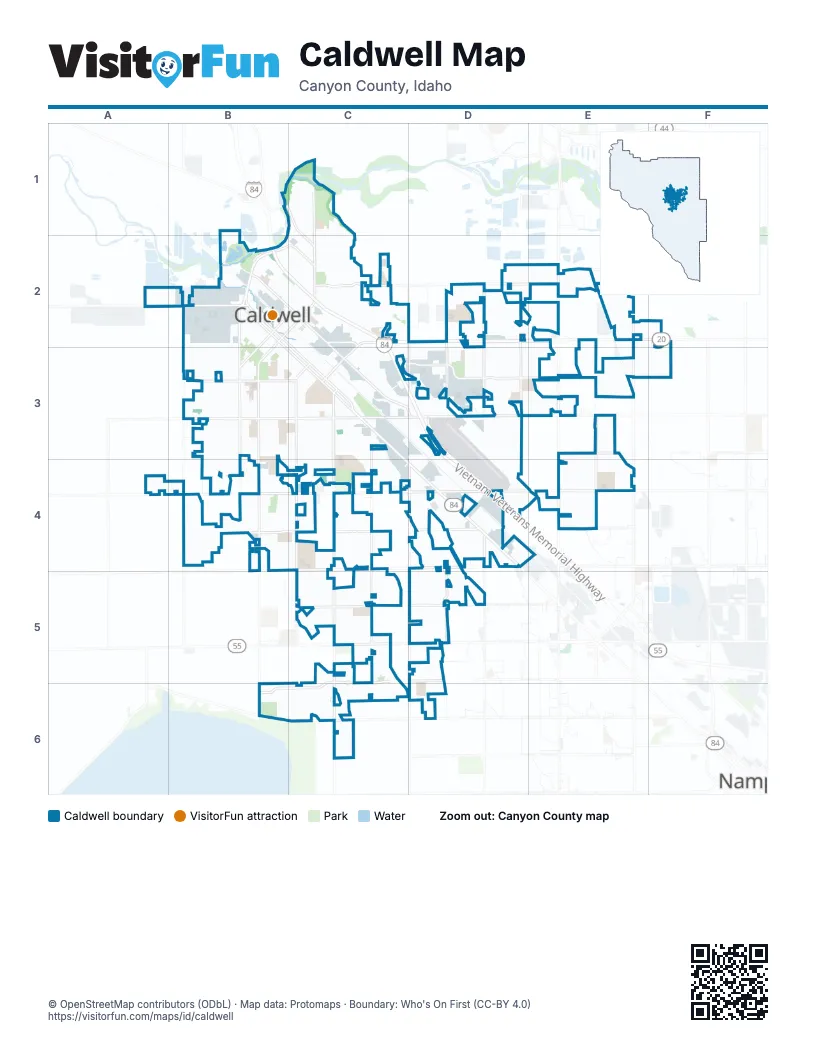
Street index of Caldwell
Each street on the sheet and the grid squares it crosses.
- Vietnam Veterans Memorial HighwayB2, C2, C3, D3, D4
- Idaho Medal of Honor HighwayB2, C2, D2, E2, F2
- Cleveland BoulevardB2, B3, C3, D4
- South 10th AvenueB2, C2, B3, B4, B6
- Blaine StreetB2, C3
- Centennial WayB2, C2
- North Illinois AvenueC1, C2
- Karcher RoadC5, D5
- Franklin RoadC2, D2
- State Highway 19B2
- Simplot BoulevardA2
- North 10th AvenueC2
- Caldwell BoulevardD4
- South Indiana AvenueC2, C3, C4, C5, C6
- East Ustick RoadB4, C4, D4
- East Linden StreetB3, C3, D3
- Middleton RoadE2, E3, E4
- Ustick RoadA4, B4, D4, E4
- Farmway RoadB4
- Linden StreetD3
- Linden RoadD3, E3
- West Ustick RoadB4
- South 21st AvenueC3
- North 21st AvenueC2, C3
- East Madison StreetC2
- West Madison StreetB2, C2
- South 24th AvenueC3
- South Montana AvenueC3, C4, C5, C6
- South Florida AvenueC2, C3, C4, C5, C6
- Aviation WayD2, D3, D4
- Homedale RoadB4, C4, D4
- Cirrus DriveC5, D5, B6, C6
- East Chicago StreetB2, C2, C3, D3
- Marble Front RoadC2, D2, E2
- South Kimball AvenueB2, B3, B4
- Lincoln RoadC2, D2, E2
- Skyway StreetD3, E3
- South Kcid RoadD2, D3
- Moss StreetC5, D5
- Laster LaneD4, E4
- Midland BoulevardE2, E3, E4
- Spruce StreetB3, C3, E3
- Santa Ana AvenueE3, E4
- Laster StreetB4, C4, D4
- West Orchard AvenueB6, C6, D6
- Lake AvenueD4, D5
- North Midway RoadD4, D5
- Celeste AvenueD4, D5
- West Plymouth StreetB1, C1, C2
- Ward RoadD2, D3
- Smeed ParkwayD2, D3
- West Linden StreetB3
- Paynter AvenueB2, B3
- East Logan StreetB3, C3
- West Logan StreetB3
- West Chicago StreetB2
- Skyway DriveD3, E3
- South Lake AvenueD3, D4
- South 17th AvenueC3
- East Homedale RoadB4
- North Kcid RoadD2
- East Plymouth StreetC2
- Moss LaneD5
- Arthur StreetB2, C2, C3, D3, D4
- Everett StreetB2, B3, C3, C4, D4
- Dearborn StreetB2, B3, C3, C4, D4
- Airport AvenueB2, B3, B4
- Sunset AvenueB2, B3, B4
- East Beech StreetB3, C3
- Fillmore StreetB2, B3, C3
- Main StreetB2, C2, C3
- Washington AvenueB3, C4
- College AvenueC3, C4
- East Elgin StreetB2, C2
- Idaho AvenueB3, B4
- South Colorado AvenueC3, C4
- East Denver StreetB2, C2
- East Ash StreetB3, C3
- South Georgia AvenueC2, C3, C4, C5, C6
- Cherry StreetC3
- Arlington AvenueB3
- North Indiana AvenueC1, C2
- Ray AvenueB3, B4
- Locust StreetC3
- Albany StreetB2, C2
- South Illinois AvenueC3, C4
- Iowa AvenueC3, C4
- Grant StreetB2, B3, C3
- South Ohio AvenueC3, C4
- East Maple StreetB3, C3
- North 5th AvenueB2, C2
- East Belmont StreetB2, C2
- East Oak StreetB3, C3
- North 3rd AvenueB2, C2
- Knott LaneF3
- West Ash StreetB3
- Laurel StreetB2
- Alder StreetB3, C3
- Cumulus WayC5, C6
- East Freeport StreetB2, C2
- Willow StreetB3, C3
- Manchester DriveB3, B4
- Oregon AvenueB3, B4
- Stockbridge WayD2
- Apache DriveD4
- North Michigan AvenueC2
- East Galveston StreetB2, C2
- Boise AvenueC1, B2, C2
- South 9th AvenueB2, B3
- Walnut StreetB3, C3
- South 5th AvenueB2
- South 6th AvenueB2, B3
- Barkley WayC4
- Arrowhead DriveC3, D3
- Marshall AvenueB3, B4
- Syringa LaneC2
- North la Cresta AvenueC1, C2
- Garber StreetB2
- North 7th AvenueB2, C2
- Ormsby AvenueD4
- Bear LaneB4
- Old Friendship WayC5
- East Elm StreetB3, C3
- Polk StreetC2
- North 9th AvenueB2, C2
- Meadow AvenueB3, B4
- North Kimball AvenueB2, C2
- East Frontage RoadB2, C2
- Teton AvenueC1, C2
- Patriot AvenueD5, D6
- Billowy WayC6
- North 1st AvenueB2, C2
- War Eagle RoadD4
- Hannibal StreetB2, C2
- Andy LaneC3, D3
- Bristol AvenueB3, B4
- Asbury WayD4
- Commercial WayC2, C3
- Oxbow AvenueB4
- Aspen Hill DriveD2, E2
- Weston AvenueD4
- East Ithaca StreetB2, C2
- North Georgia AvenueC2
- Endicott DriveD2
- Hillcrest LaneC2
- Wyoming AvenueC3
- Larch StreetC4
- South 16th AvenueB3, C3
- South Kit AvenueB2
- Fuchsia AvenueD5, D6
- Ward LaneD2
- Enterprise WayD3
- Hird AvenueC1
- Terrace DriveC1, C2
- Fairview AvenueB3
- Bayou WayC5
- North 4th AvenueB2, C2
- Breton WayD4, D5
- Dunning WayC5
- Ashton AvenueD4
- Rice AvenueC1
- North Plateau AvenueC1, C2
- Smiley Peak AvenueE3
- North 14th AvenueC2
- South 18th AvenueC3
- Virginia ParkwayD2
- West Hazel StreetB3
- Muller LaneC2, D2
- Susquehanna WayD3, E3
- Joliet StreetB2, C2
- South 12th AvenueC2, B3
- Shadow Glen RoadD3, E3
- Fractus DriveC6
- Sky Lake DriveC6
- Dietz WayC5
- Midway Mobile HomesD4
- Toscano WayC5, C6
- Chambers WayC4, C5
- Cooper Sunrise DriveB6, C6
- West Elm StreetB3
- Boatwatch DriveB6, C6
- Ellis AvenueB3
- Jennings WayD2
- Stock Trail RoadC3
- Griffiths ParkwayC3
- Sage DriveD3, D4
- Shelburne StreetD3
- South 4th AvenueB2
- North Ohio AvenueC1, C2
- Lincoln StreetC2
- Sequoia Grove WayC5, C6
- East Kearney StreetC2
- Industrial WayC3
- Longtail DriveE4
- Mountain Springs AvenueE4
- Monarch WayE4
- Gap Creek AvenueB4
- Mesa Springs AvenueE4
- Roosevelt StreetC1, C2
- Brookside DriveB3
- Wilderness DriveD3, E3
- Lignite DriveD5
- Bluefield DriveE3
- Middlesboro WayB4
- Barn Ranch StreetD2, E2
- Roanoke DriveD2
- South 7th AvenueB2
- New Colony AvenueC5
- Poplar StreetB3, C3
- South 20th AvenueC3
- Altamont StreetD2
- Dragonfly DriveE4
- Nora DriveD3, E3
- Sentinel AvenueC5
- Ironstone DriveD5
- Lewers WayC5
- Graye LaneD4
- Rimview DriveC1, C2
- Wing Spread DriveB6
- Chicago StreetB2
- Nimbus WayC6
- Powderhorn DriveC3, D3
- Antelope WayB4
- West Beech StreetB3
- North 6th AvenueB2, C2
- South 15th AvenueC3
- Pioneer AvenueB4
- South 14th AvenueB3, C3
- North 11th AvenueC2
- North Montana AvenueC1
- Avalon StreetE4
- Fishertown AvenueD3
- Alleghenny WayD2, D3, E3
- Dorman AvenueB3, B4
- Colfax DriveC4
- Nixon StreetC2
- South 3rd AvenueB2
- Ripples DriveC6
- Syringa PlaceC2
- Carnegie StreetC4
- Nez Perce RoadD4
- Settlers AvenueB4
- Vistapark DriveC2
- Royal WayE4
- Carolina StreetC5
- Loggia AvenueD5
- Hargrove AvenueD4
- Quail Meadow LoopB3
- Settlers StreetB4
- Shoshoni RoadD4
- Challenger WayD3
- Wilmington StreetD2
- South 13th AvenueC2, B3
- West Elgin StreetB2
- Fawnsgrove WayD3
- North Alaska AvenueC2
- South 19th AvenueC3
- Bannock DriveD3, D4
- East Hazel StreetB3, C3
- Savannah StreetC1
- Adirondack WayE2, E3
- Kenney WayD3
- Parker AvenueB3, B4
- Cloud Crest AvenueC6
- West Oak StreetB3
- Ware House StreetB2
- Dynasty AvenueC4
- Empress StreetE4
- Moreno DriveC5
- North 13th AvenueC2
- Towhee StreetD5
- Trailside DriveB4
- Pillar Rock StreetC6
- Harvester AvenueE4
- Sonoran AvenueE4
- London Park PlaceD5
- Sunridge DriveB3
- West Freeport StreetB2
- Colebrook AvenueD2
- Wallace WayC4
- Harrison StreetB2, B3
- Moosehorn WayC5, C6
- North 16th AvenueC2
- Junegrass WayC4
- Dark Zebra WayE4
- Cambria StreetD3
- Red Mountain StreetE2
- Spicebush AvenueE3, E4
- Blue Ridge StreetC5
- Fairoaks DriveC3, C4
- Carlin AvenueC5
- Boomerang WayC4
- Meander Creek WayD5
- East Morrison StreetB3
- East Ross LaneB4
- South Wisconsin AvenueC3
- South Michigan AvenueC3, C4
- Bridgeport AvenueC2
- Hazy Glen DriveE4
- Signorello StreetC6
Things to do on the Caldwell map
Places on the map
- Abundant Life RV Park
- Albertsons
- All Parts Brokers Auto Salvage
- Ambassador RV Resort
- American Muffler Auto Repair and Custom Exhaust
- Brothers Athletic Park
- Caldwell Commons
- Caldwell Executive Airport
- Canyon County Courthouse
- Canyon Hill Cemetery
- Canyon Springs High School
- Curtis park
- Flying J Travel Center
- Grace Assisted Living
- Griffiths Park
- Indian Creek Park
- Jefferson Middle School
- Lakevue Elementary School
- Lions Park
- Luby Park
- Mallard Park
- Memorial Park
- Pipe Dream Park
- Rotary Pond
- Rotary Pond Park
- Sacajawea Elementary School
- Sebree Park
- Stor-It
- Store Local Storage Co-Op
- Summitvue Middle School
- Syringa Middle School
- Terrace Drive-In
- United States Post Office
- Ustick Park
- Vallivue High School
- Van Buren Elementary School
- Vision Charter School
- Walmart Supercenter
- West Valley Medical Center
- Whittenberger Park
Next to Caldwell
© OpenStreetMap contributors, Open Database License, openstreetmap.org/copyright · Map data: Protomaps · Boundary: Who's On First (CC-BY 4.0); Quattroshapes (CC BY 2.0)