

Idaho map
Idaho Falls map
About 69,523 people live here (Census Bureau, 2024 estimate). The sheet's index lists 300 streets; Veterans Memorial Highway, South 25th East and South Yellowstone Highway cross the most grid squares. Things to do inside the boundary: Grand Teton Mall, Idaho Falls Zoo At Tautphaus Park and Museum of Idaho.
Open the map (PDF, US Letter)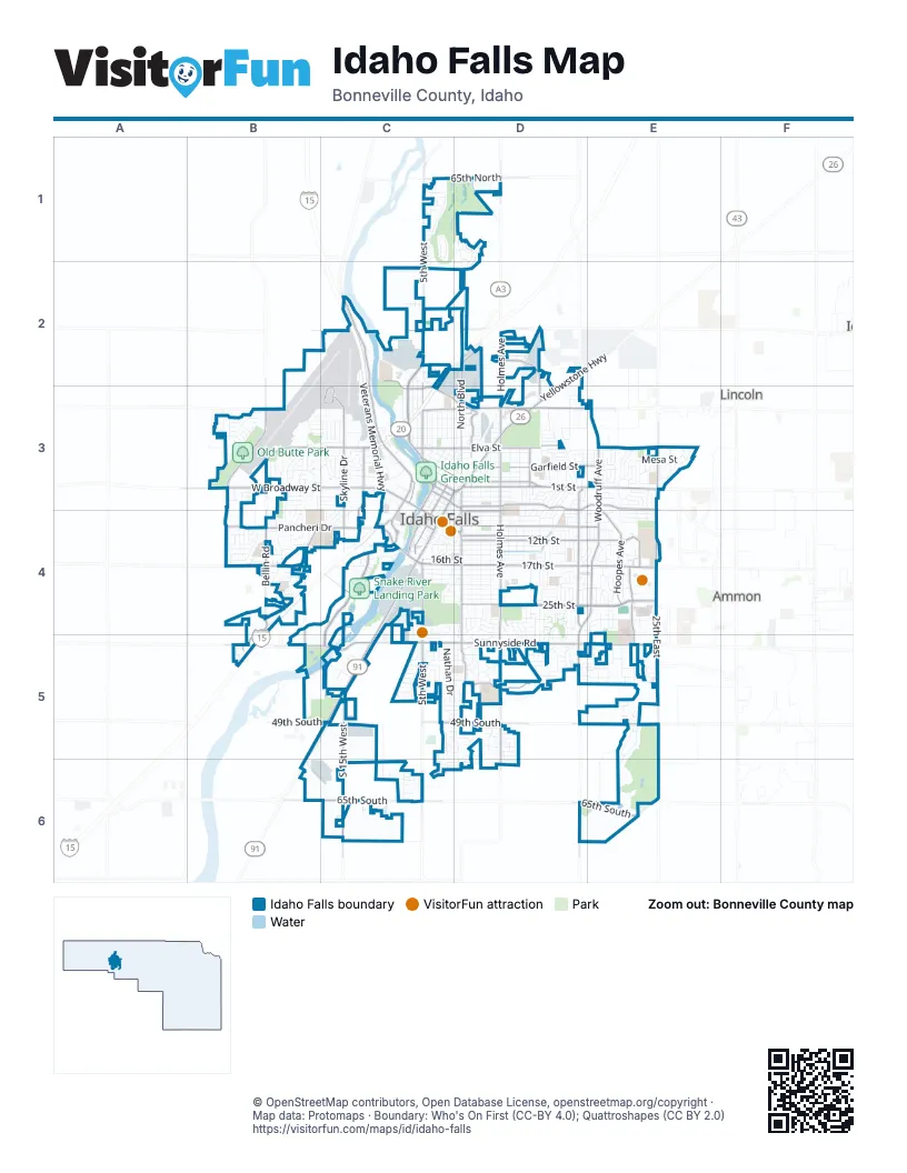
Street index of Idaho Falls
Each street on the sheet and the grid squares it crosses.
- Veterans Memorial HighwayC2, C3, B4, C4, B5
- South 25th EastE3, E4, E5, E6
- South Yellowstone HighwayC4, B5, C5, B6
- West Broadway StreetB3, C3, C4
- East 17th StreetD4, E4
- East Sunnyside RoadD5, E5
- Pancheri DriveB4, C4
- South Woodruff AvenueE3, D4, E4, D5
- West Sunnyside RoadB5, C5, D5
- Grandview DriveB3, C3
- Northgate MileD3
- Science Center DriveC2, C3, D3
- North Holmes AvenueD2, D3
- Yellowstone AvenueC3, D3, C4
- East Anderson AvenueD3
- North 25th EastE3
- North Yellowstone HighwayD2, D3
- West 17th StreetC4, D4
- North Woodruff AvenueE3
- Lincoln RoadD3
- South Holmes AvenueD3, D4, D5
- 1st StreetD3, E3
- Fremont AvenueC2, C3
- North 5th WestC1, C2
- North Skyline DriveC3
- South 5th WestC5, C6
- West 65th SouthB6, C6
- South Utah AvenueC3, C4
- Channing WayE4, E5
- Lomax StreetD3
- East 65th SouthD6, E6
- South 15th EastD5, D6
- Memorial DriveC3
- South Skyline DriveC3, C4
- Riverside DriveC3
- East Lincoln RoadD3
- North 5th EastD1
- East Iona RoadD2
- East 25th StreetD4, E4
- Lindsay BoulevardC2, C3
- Snake River ParkwayC4, C5
- 12th StreetD4, E4
- South BoulevardD3, D4, D5
- John Adams ParkwayD3, E3
- Saint Clair RoadD3, D4
- 9th StreetD4, E4
- South 15th WestC5, C6
- North BoulevardD2, D3
- Garfield StreetD3, E3
- Hoopes AvenueE4
- South Bellin RoadB4
- East 49th SouthD5, E5
- North 26th WestB3
- East Elva StreetD3
- 11th StreetD4
- Rollandet AvenueC4, C5
- West 17th SouthB4
- Hemmert AvenueD2, D3
- Jefferson AvenueC2, C3
- Stonebrook LaneD5
- West 49th SouthB5, C5
- Castlerock LaneD5
- Grizzly AvenueB4
- South Capital AvenueC4
- West Elva StreetC3, D3
- North Lee AvenueD3
- I StreetC3, D3
- West Anderson AvenueC3, D3
- East 65th NorthD1
- Ashment AvenueE4
- Park AvenueC3, C4
- South Saturn AvenueC3, C4
- Event Center DriveC4
- Saturn AvenueC3
- Outlet BoulevardB4, B5
- West 65th NorthC1, D1
- 5th StreetD3
- North Fanning AvenueD3
- 6th StreetD4
- Chamberlain AvenueC4
- West 17th NorthB3
- Old Butte RoadB3, B4
- Elm StreetC4, D4
- West 33rd NorthC2
- E StreetC3
- F StreetC3, D3
- Dunbar DriveD3
- South Pioneer RoadC4
- West 33rd SouthB5
- North Utah AvenueC3
- D StreetC3
- Wadsworth DriveD3
- South Pioneer LaneB5
- East Stanley StreetD2
- Birch StreetC3, D3
- North Bellin RoadB3
- Cliff StreetC4
- East 33rd NorthD2
- Temple PlaceC3
- Knight WayE4
- Brianne AvenueE4
- West Anderson StreetD3
- South Higbee AvenueD3, D4
- South Emerson AvenueD3, D4
- South Lee AvenueD3, D4
- 10th StreetD4
- East 16th StreetD4, E4
- River ParkwayC3
- Kearney StreetD3, E3
- East 13th StreetD4
- Milligan RoadC4
- East 14th StreetD4
- 7th StreetD4
- Foote DriveC2, C3
- 8th StreetD4
- Gleneagles DriveC1, C2
- East 21st StreetD4
- Balboa DriveE4
- MK Simpson BoulevardC2
- Hollipark DriveD3
- Southpoint BoulevardC5, D5, D6
- Hartert DriveD4, D5
- East 15th StreetD4
- Cleveland StreetD3
- Nathan DriveC5
- Eastview DriveE3
- Clarence DriveB3
- Brentwood DriveB3, C3, C4
- North Emerson AvenueD3
- Canyon AvenueC2, C3
- Homer AvenueD3, D4, E4
- Coronado StreetE4
- Elmore AvenueC2, C3
- May StreetD3
- 4th StreetD3
- Olympia StreetB3, C3
- Long Cove DriveE5, E6
- Woodhaven LaneC5, D5
- Meppen DriveE3, E4
- Whittier StreetD3
- North Higbee AvenueD3
- West 19th StreetC4, D4
- Brandon DriveB4
- Gladstone StreetD3
- Springwood LaneD4, D5
- West 21st StreetC4, D4
- 2nd StreetD3
- 3rd StreetD3
- West Shelley StreetC3, D3
- Iona StreetC3, D3
- Mesa StreetE3
- Bluebird LaneB4
- Newman DriveB4
- Beulahs LaneE3
- Shoup AvenueC3, C4
- Calkins AvenueC4
- Cassia AvenueC3
- Linden DriveD3, D4
- College StreetD3
- Cobblestone LaneC5, D5
- Cranmer AvenueD4
- Lincoln DriveD3, D4
- J StreetC3, D3
- River Walk DriveC4
- Buckboard LaneB3
- Washington ParkwayE5
- Blue Sky DriveB4, C4
- Masters DriveE3
- Escalante AvenueD4, D5
- Tuscany DriveC5
- West Crowley StreetC3, D3
- Cultural CircleC3
- Chaparral DriveD4, D5
- Homestead LaneD4, D5
- Raymond DriveC3
- West 20th StreetC4, D4
- Northwest Bonneville DriveD3
- Wardell AvenueC3
- Malibu DriveE4
- Mojave StreetD4
- Londonderry AvenueD4, D5
- Dickson AvenueB3, B4
- Austin AvenueD4
- Fieldstream LaneD4, D5
- Eaglewood DriveD1, D2
- Royal AvenueD3
- Davidson DriveE3
- Periska WayB4
- Casa DriveD5
- Monticello DriveE4
- Pevero DriveD1, C2, D2
- Ada AvenueD3
- Valencia DriveE4, E5
- Bannock AvenueC3
- Curtis AvenueC4
- North Freeman AvenueD3
- West 16th StreetC4, D4
- Boge AvenueD2, D3
- North Wabash AvenueD3
- Rock Hollow LaneD1
- Blaine AvenueC3
- Boise AvenueC3
- Evans AvenueB3
- K StreetC3, D3
- Coachman DriveB3
- Troy AvenueB3, B4
- East 18th StreetD4
- North Eastern AvenueC3, D3, C4
- West 18th StreetC4, D4
- East 19th StreetD4
- West Pevero DriveC2, D2
- June AvenueD4
- East 23rd StreetD4
- Jennie Lee DriveD4
- Canal AvenueC3, D3
- East 24th StreetD4
- Sykes DriveE3
- North Water AvenueD3, C4
- Southeast Bonneville DriveD4
- Syringa DriveD3
- Blue Ridge DriveB4
- North Capital AvenueC3, C4
- Bower DriveD4
- Softball DriveC4
- Nottingham LaneC5
- East 20th StreetD4
- Terry DriveD4
- DOE PlaceC2
- Caribou StreetD3, E3
- Jupiter Hills DriveC1
- Rendezvous RoadB4
- East 22nd StreetD4
- Pier View DriveC4
- Halsey StreetD3, E3
- Steeplechase LaneC5
- Brookcliff DriveB4
- Idaho AvenueC3, D3
- Johnson StreetD3, E3
- Ruth AvenueE3
- Latah AvenueC3
- Shadow Mountain TrailD5
- Colonial WayC5, D5
- Wild Dunes LaneE5
- Hansen AvenueC3
- Ironwood DriveB4
- Moonlite DriveB3
- Tyra DriveE3, E4
- Crestwood LaneE5
- Stillwater DriveC5, D5
- Tipperary LaneD4, D5
- Houston StreetC3
- West 13th StreetC4, D4
- Melrose DriveE3
- South Fanning AvenueD3, D4
- Constitution WayC3
- Holbrook DriveD3, D4
- Westmorland DriveC4, C5
- Tendoy DriveD3, D4
- Simon StreetB3
- Belmont AvenueE4
- Merritt DriveD4
- Maple StreetC4, D4
- Santalema DriveD4
- Creekside DriveD5
- Sage AvenueC3
- Summit Run TrailD5
- West 14th StreetC4, D4
- Silverado DriveC5
- Laguna DriveE4
- Alan StreetE4
- Grassland DriveD5
- Leslie AvenueC4
- Lowell DriveB4
- Richards AvenueD4
- Disney DriveD4, D5
- Bear AvenueC3
- Whitewater DriveC4
- Bingham AvenueC3
- Thayer Bridge CircleC4, C5
- Brookview DriveD5, E5
- International WayB3, C3
- Sunny Pine WayD5, E5
- Claire View LaneC3
- Rogers StreetC4, D4
- Pedersen StreetC5
- Merlin DriveE5
- Presto StreetC3
- Dalmation DriveB3
- Southwest Bonneville DriveD4
- Washburn AvenueC3
- Cambridge DriveD3, D4
- Riviera DriveE4
- Bodily StreetE4
- Potomac WayE5
- Stace StreetE4
- South Koester RoadB5, C5
- Valley DriveE3
- Shadow Creek DriveC1
- Sunken Diamond DriveC4
- Helix BoulevardB3
Things to do on the Idaho Falls map
Places on the map
- A.H. Bush Elementary School
- Bonneville County Fairgrounds
- Centennial Square
- Central Park
- Channing Square
- Community Park
- Community Park Trail
- Compass Academy
- Eagle Rock Middle School
- Eastern Idaho Regional Medical Center (EIRMC)
- Esquire Acres Park
- Ethel Boyes Elementary School
- Falls Valley Elementary School
- Fielding Memorial Park Cemetery
- Fox Hollow Elementary School
- Grand Teton Mall
- Hall Park Shopping Plaza
- Idaho Canal
- Idaho Falls Greenbelt
- Idaho Falls High School
- Idaho Falls Regional Airport
- Kensington Professional Park
- Kingswood Plaza
- Linden Park Elementary School
- Longfellow Elementary School
- Mel Erickson Sunnyside Park
- Melaleuca Field
- North Skyline Drive
- Old Butte Park
- Pinecrest Municipal Golf Course
- Practice Field Park
- Rose Hill Cemetery
- Russell A Freeman Park
- Ryder Park
- Sage Lakes Golf Course
- Sand Creek Golf Course
- Shamrock Park
- Skyline High School
- Snake River Landing Park
- Tautphaus Park
Next to Idaho Falls
- Ammon map
- Lincoln
© OpenStreetMap contributors, Open Database License, openstreetmap.org/copyright · Map data: Protomaps · Boundary: Who's On First (CC-BY 4.0); Quattroshapes (CC BY 2.0)















