

Illinois map
Geneva map
About 21,168 people live here (Census Bureau, 2024 estimate). The sheet's index lists 300 streets; Kaneville Road, North Kirk Road and Fabyan Parkway cross the most grid squares. Also on it: Eaglebrook Country Club, Fabyan Forest Preserve and Peck Farm Park.
Open the map (PDF, US Letter)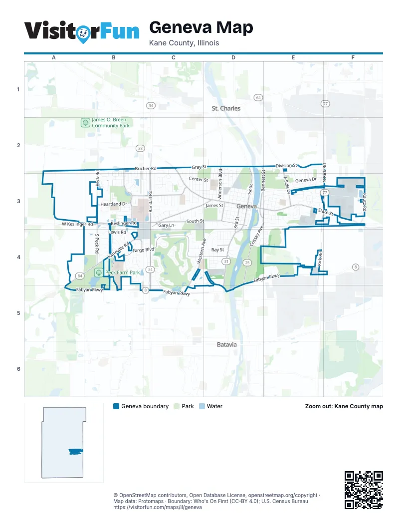
Street index of Geneva
Each street on the sheet and the grid squares it crosses.
- Randall RoadC2, C3, C4
- East State StreetD3, E3, F3
- West State StreetC2, C3, D3
- South Batavia AvenueD4, D5
- South Randall RoadC4, C5
- North 1st StreetD2, D3
- South 1st StreetD3, D4
- West Roosevelt RoadF3
- State StreetD3
- Lincoln HighwayC2
- Kaneville RoadC3, D3, A4, B4, A5
- Fargo BoulevardB4, C4, D4
- North Kirk RoadF2, E3, F3, E4
- Crissey AvenueD3, E3, D4
- Fabyan ParkwayD4, A5, B5, D5
- West Fabyan ParkwayC5
- East Fabyan ParkwayD4, E4
- Keslinger RoadB3, C3
- North Bennett StreetD2, E2, D3, E3
- South Peck RoadB3, B4
- Peck RoadB3, D4
- West Keslinger RoadB3
- South Bennett StreetD3, E3
- North Washington AvenueD4
- South StreetC3, D3
- Western AvenueD3, C4, D4, C5
- Williamsburg AvenueB3, C3
- East Side DriveE3
- Fisher DriveB2, B3
- Kautz RoadF3
- Bricher RoadB2, C2
- Viking DriveB4, B5
- Heartland DriveB3
- South 3rd StreetD2, D3, D4
- Anderson BoulevardD2, D3
- South 7th StreetD2, D3
- South Fisher DriveB3
- Gary LaneC3
- Kirk RoadE4
- Wenmoth RoadB5
- Lewis RoadB4
- Cambridge DriveC2, C3
- Peyton StreetC3, D3
- Fox Run DriveD4, E4
- Center StreetC3, D3
- Ford StreetC3, D3
- James StreetD3
- Gray StreetC2, D2
- Commons DriveC2, B3, C3
- Bent Tree DriveC4, C5
- Geneva DriveE3
- Westhaven CircleB3
- Stevens StreetD3
- Meadows RoadD4
- Averill RoadF3
- Richards StreetD3
- Dunstan RoadD4
- Miller RoadB4, C4
- Westfield CourseE2, E3
- Mc Kinley AvenueD2, D3
- Logan AvenueD2, D3
- Cheever AvenueD4
- Keim CircleC4
- Campbell StreetD3
- Samantha CircleB3, B4
- Sunset RoadD4
- Dodson StreetD3, E3
- Eagle Brook DriveC4
- Ridge Pointe DriveB2, B3
- Hamilton StreetD3
- Union StreetD2, D3
- Maple LaneC3
- Franklin StreetD3
- Fulton StreetD3
- North StreetC3, D3
- Eldorado DriveC4
- Woodward AvenueD3, E3
- Colonial CircleC3
- South 6th StreetD2, D3
- South 5th StreetD2, D3
- Willow LaneC2, C3
- Wakefield LaneC3
- Fairway CircleC4
- Pepper Valley DriveC3
- Prairieview DriveB3
- Kirkwood DriveE3
- Sunflower DriveB4
- South 4th StreetD2, D3
- Sandholm StreetE3
- Wood AvenueB4
- Brigham WayC4
- Manchester CourseE3
- Allen DriveC4, D4, D5
- Camden StreetB2, B3
- North Lincoln AvenueD2, D3
- Larrabee DriveB3
- School StreetE3
- West LaneC2, C3
- St Andrews CircleC4
- Sterling AvenueB4
- Husking Peg LaneB3
- Blackberry DriveC2, C3
- South 2nd StreetD3
- Ray StreetD4
- Hill RoadE3, F3
- Oakwood DriveE3
- Oak StreetD3, E3
- Ridge LaneE3
- Spring StreetE3
- Burgess RoadC3
- Chesapeake WayE3
- South River LaneD3
- Hillcrest RoadB3
- North 2nd StreetD3
- Eklund AvenueD2
- Jefferson StreetD3, E3
- Bluestem DriveB4
- North River LaneD3
- Lorraine CircleB3
- Charles StreetC3
- Kings CourtC4
- Redwing DriveC4, D4
- Grant AvenueD3
- Sheffield LaneC3
- Division StreetE2
- Heather RoadC4
- Nelson DriveB3
- North Glengarry DriveE3
- Hawthorne LaneD4
- Simpson StreetE3
- Blackman RoadB4
- Shepherd LaneB2, B3
- Whitfield DriveE3
- Illinois StreetD2, D3
- Longview DriveE3
- Edison StreetD2, D3
- North Pine StreetC3
- Lancaster LaneE2, E3
- Stone CircleB3
- Considine RoadC5
- North 4th StreetD3
- Eleanor LaneB3
- Chandler AvenueE2, E3
- Border RoadB3
- Larsdotter LaneB3
- Patten AvenueB4
- Brittany CourtC3
- Cedar AvenueB4
- Vanderbilt DriveC2
- Randall CourtC4
- North 6th StreetD3
- North 3rd StreetD3
- North 5th StreetD3
- Willowbrook WayB3
- Briar LaneE3
- Wild Prairie LaneB4
- Berkshire DriveB4
- South Glengarry DriveE3
- Cannon DriveB3
- Shoop DriveB4
- Danford WayB4
- Brentwood PlaceE3
- Easton AvenueD4
- Keim CourtC4
- Highbury LaneC2, C3
- Longmeadow DriveE3
- Kaneville CourtB4, C4
- Adamson DriveB3
- Caldwell LaneB3, B4
- Country Squire DriveC4
- Merchant DriveC4
- Kansas StreetE3
- Britta LaneE3
- North Raddant RoadE4
- SouthamptonC3
- Kane StreetE3
- West StreetC3
- Nebraska StreetE3
- South 8th StreetD3
- Garfield StreetE3
- Old Kirk RoadF3
- Woodlawn StreetE3
- Daniels WayB3
- Herrington RoadB4
- Windett LaneB2, B3
- Vonder LaneD4, E4
- Stratford DriveC3
- Pheasant Run PlaceC4, D4
- Euclid AvenueD3, E3
- Chalmers StreetE3
- Clover LaneC3
- Deerfield WayC3
- Bradbury LaneC2, C3
- Dempsey PlaceC3
- Harrison StreetE3
- Bloomfield CircleC3
- South Northampton DriveC3
- Foxwood CircleE3
- Gleneagle DriveC4
- Pillsbury DriveF3
- May StreetD2, D3
- Wall StreetD3, E3
- Elm AvenueE2
- Appleton LaneE2
- Valley LaneE3
- Highland RoadB4
- Wild Dunes CourtC5
- Sherman AvenueC3
- Greenfield CircleE3
- Hawley LaneD4
- Austin AvenueE3
- Walnut CircleB4
- Fieldstone DriveB3
- Averill CircleE3
- Winding Meadow LaneB4
- Syril DriveC3
- Stonewood Glen DriveB4
- Foxford LaneD4
- Lexington DriveE2, E3
- Mayborne LaneB3
- Harvest Ridge RoadB3
- Nichole LaneE2
- Green Meadow LaneE2, E3
- Tanager LaneC4, D4
- Campbell CourtD3
- Forest View DriveD4
- Pebble Beach CourtC4
- Aberdeen CourtE3
- Howell DriveE2
- Bridgeport LaneC3
- Bedford LaneC3
- Kendall StreetD4
- Marion AvenueD4
- Innovation DriveF3
- North Northampton DriveC3
- Forest AvenueD4
- Country Club PlaceC3
- Dearborn CourtF3
- Summit StreetE3
- Dow AvenueD4
- South Harrison StreetE3
- Kane CountyD4
- Turnberry CourtC4
- Downing PlaceE2, E3
- Howard StreetE3
- Ginger LaneB4
- Hawkins WayB3
- Creekside DriveD3
- Scott BoulevardC3
- Lilyrose LaneC4, D4
- 6th AvenueE2, E3
- Locust AvenueE3
- Kenston CourtD3
- Sudbury LaneC3
- Soderquist CourtB4, C4
- Christina LaneC4
- Alexandria CourtE3
- Arlington CourtE3
- Bluegrass LaneB3
- South Pine StreetC3
- Garden AvenueD4
- Kingston DriveE3
- Abbey LaneB3
- Lineas LaneB3
- Elm RoadF3
- Park AvenueE3
- Chronicle RoadB4, C4
- Patricia LaneE2
- Brookfield LaneC3
- Brookway DriveC3
- South Lincoln AvenueD3
- Joshel CourtE3
- South 12th StreetC2
- Thoria RoadD4
- Loran DriveC4
- Blazing Star CourtB4
- Cornwall LaneB3
- Commerce DriveE3
- North Greenwich LaneC3
- Rosenfelder CourtC3
- North Andover LaneC3
- Heritage CourtB4
- Linden CourtD3
- Rockefeller DriveC2
- Parker CourtE2, E3
- High StreetE2
- Homsted LaneB3
- Whittington DriveE3
- Shady AvenueD4
- 3rd AvenueE2
- Bank LaneE3, F3
- Knollwood CircleB3
- Delaware CourtE3
- Mead CourtD3
- Oldmill CourtB4
- South Greenwich LaneC3
- Belter CourtC5
- Natwill SquareD3
- Paddock CourtC3
- South Andover LaneC3
Places on the map
- Aldi
- Amstar
- Ashley HomeStore
- At Home
- Burgess Field
- Don Forni Park
- driving range
- Dryden Park
- Eaglebrook Country Club
- Eaglebrook Park
- Fabyan Forest Preserve
- Foundation Park
- Fox Valley Presbyterian Church
- Geneva Commons
- Geneva Community High School
- Geneva Golf Club
- Geneva Middle School North
- Geneva Middle School South
- Good Templar Acquisition
- Good Templar Park
- Gunnar Anderson County Forest Preserve
- Heartland Elementary
- Island Park
- Kane County Government Center
- Moore Park
- Northwestern Medicine Delnor Hospital
- Oak Hill Cemetery
- Peck Farm dog park
- Peck Farm Park
- Peck Lake
- Randall Commons
- Riverside Park
- Sandholm Woods
- South Street Athletic Fields
- Stanley A. Esping Park
- Sunset Park
- The Home Depot
- Wheeler Park
- Williamsburg Elementary School
- Williamsburg Park
Next to Geneva
© OpenStreetMap contributors, Open Database License, openstreetmap.org/copyright · Map data: Protomaps · Boundary: Who's On First (CC-BY 4.0); U.S. Census Bureau















