

Illinois map
St. Charles map
About 52,511 people live here (Census Bureau, 2024 estimate). The sheet's index lists 300 streets; Oak Street, East Main Street and Lincoln Highway cross the most grid squares. Things to do inside the boundary: Pottawatomie Park.
Open the map (PDF, US Letter)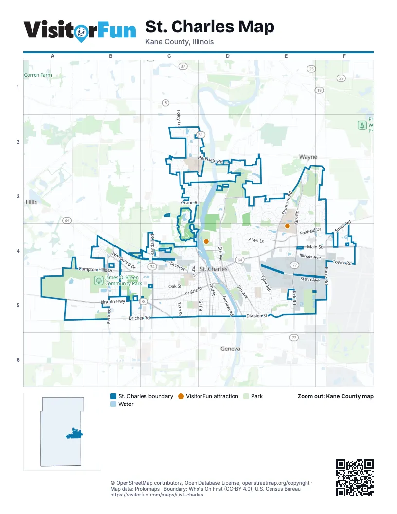
Street index of St. Charles
Each street on the sheet and the grid squares it crosses.
- East Main StreetD4, E4, F4
- Lincoln HighwayA5, B5, C5
- West Main StreetB4, C4, D4
- Peck RoadB4, B5
- North Randall RoadC4, C5
- South Randall RoadC4, C5
- South 2nd StreetD4, D5
- Geneva RoadD5
- North 2nd StreetC4, D4
- Randall RoadC4, C5
- North AvenueD4, F4
- Main StreetD4
- North 1st StreetD5
- North Kirk RoadE3, E4, E5
- Dunham RoadE3, E4
- North 5th AvenueD3, D4
- South Kirk RoadE4, E5
- Red Gate RoadC2, D2
- South Riverside AvenueD4, D5
- South 5th AvenueD4, D5
- North Bennett StreetD5
- Prairie StreetC5, D5
- Campton Hills DriveA4, B4
- South Tyler RoadE4, E5
- South 7th AvenueD4, D5, E5
- Dean StreetC4
- Kautz RoadF4, F5
- South 3rd StreetD4, D5
- Bricher RoadB5, C5
- Smith RoadF3, F4
- Foxfield RoadE4
- Country Club RoadD3, E3
- East Tyler RoadE5
- Crane RoadC3, D3
- East Side DriveE5
- North 9th StreetC4
- Oak StreetB4, B5, C5, D5
- Fox Chase BoulevardE3, D4, E4
- Persimmon DriveD3, D4
- Royal Fox DriveE2, E3, F3
- Illinois AvenueD4, E4, F4
- Horne StreetC5, D5
- Production DriveD4, E4
- Fox Glen DriveD2, E2, D3
- Division StreetD5, E5
- Greenwood LaneC2, C3
- Ohio AvenueD4, E4, F4
- South 14th StreetC4, C5
- Indiana StreetD4, C5, D5
- Woodward DriveB4, C4
- South 4th StreetD4, D5
- Lakeside DriveE4
- South 7th StreetC4, C5, D5
- South 12th StreetC4, C5
- South 6th StreetC4, C5, D5
- Fellows StreetC5, D5
- South 5th StreetD4, D5
- Ronzheimer AvenueD5, E5
- North 3rd AvenueD4
- Rita AvenueD5, E5
- Stonehedge RoadD4
- Madison AvenueD5, E5
- Keim TrailD3, E3, D4
- Foxfield DriveE4, F4
- Walnut StreetC4, D4
- Swenson AvenueE5, F5
- Stern AvenueE5, F5
- Moore AvenueD5, E5
- South 13th AvenueD4, D5
- North 2nd AvenueD4
- Adams AvenueD4, D5
- Howard StreetC5
- South 13th StreetC4, C5
- King Edward AvenueF3, F4
- Mosedale StreetC5, D5
- Indiana AvenueD4
- 11th AvenueD4, D5
- 10th AvenueD4, D5
- Allen LaneD4, E4
- Valley View DriveB4, B5
- High Gate CourseE3
- South AvenueD4, D5
- South 10th StreetC4, C5
- Tower RoadF4
- Turnberry RoadE3
- South 12th AvenueD4, D5
- Wallace AvenueE5
- 38th AvenueE4
- 37th AvenueE4
- St Germain PlaceB4
- Millington WayC4
- Jewel AvenueD5, E5
- South 11th StreetC4, C5
- Forest Ridge RoadE4
- Cedar AvenueD4
- Roosevelt StreetD5
- Majestic Oaks DriveE3, F3
- Pleasant Plains DriveB4, B5
- Wessel CourtC5
- Gray StreetC5, D5
- Illinois StreetD4, C5, D5
- Mc Kinley StreetD5
- Renard LaneB4
- Jeanette AvenueE5
- Independence AvenueE4, E5
- Cumberland Green DriveE5
- Karl Madsen DriveA5, B5
- Timbers TrailC4
- Equity DriveE5
- South 6th AvenueD4, D5
- King James AvenueF3
- View Pointe DriveD5
- North Tyler RoadD4, E4
- Tradition DriveE3, E4
- Whittington CourseD3, E3
- Brook StreetC4
- Charlemagne LaneE3, F3
- Cutler StreetC5, D5
- Greywood DriveC2
- Pheasant TrailF4
- Industrial DriveE4
- South 19th StreetC4, C5
- Cambridge DriveE5
- Heritage StreetB5
- Steeple Chase RoadD4
- Royal and Ancient DriveE3
- Wildrose Springs DriveC3, C4
- Aintree RoadE3
- Fox Chase DriveE3, E4
- Longmeadow CircleD4
- Reserve DriveC2, D2
- South 9th StreetC5
- Winners Cup CircleD3, E3, E4
- River Ridge DriveC2
- Chasse CircleE3
- Patricia LaneE5
- South 8th StreetC5
- Shoreline DriveC3
- State AvenueD4
- Stuarts DriveE4
- Banbury AvenueD5, E5
- Meadow RoadD3
- Hampton CourseD3
- Waverly CircleE4
- Redhawk RoadE3
- Bill Barth DriveD3
- Iroquois AvenueD4
- South 9th AvenueD4, D5
- Pleasant AvenueD5, E5
- South Elm StreetD5
- Forrest BoulevardE5
- Francis CircleE3
- Larson AvenueE5
- Voltaire LaneB4
- Royal Saint Georges CourtE3
- Prairie Crossing DriveC2, D2
- North 12th StreetC4
- Glenbriar DriveD2, D3
- Bridle CourtE3
- King Richard CircleF3
- Charlestowne Lakes DriveF4
- Langston CircleB5
- South 17th StreetC4, C5
- South 4th AvenueD4, D5
- Lakewood CircleC3, C4
- Chesapeake RoadC2, C3
- Sunbury DriveB4, B5
- North 4th AvenueD4
- Southgate CourseE3, E4
- Walnut AvenueD4
- Foley LaneC2
- Dukane DriveE4
- Horizon DriveB5
- Grand View CourtC2
- Northwinds DriveB5, C5
- Dunham PlaceE4
- Renaux BoulevardB4
- Blackhawk TrailE4
- White Oaks CircleD5
- Foundry StreetC4
- Legacy BoulevardE5
- Meadow View DriveC2
- Hunt Club DriveD4
- Red Sky DriveB5
- Cedar StreetC4, D4
- Fairfax RoadE4
- Grand Ridge RoadB4, B5
- Thoroughbred CircleD4, E4
- Walnut DriveC4, C5
- Wing AvenueD4
- Hamilton RoadB4
- South 3rd AvenueD4, D5
- Stirrup Cup CourtE3
- South 18th StreetC4, C5
- Richards StreetD5
- Midway AvenueE5
- Hilldale DriveC2
- Tower Hill DriveB4, B5
- Huntington RoadE4
- Provence DriveB4
- Deville LaneB4
- Windsor CircleC3
- Fairview DriveC5
- Jackson AvenueD4, D5
- Pheasant CourtF4
- West State StreetC4, D4
- Matisse DriveB4
- Crestwood CircleC4
- Monroe AvenueD4, D5
- North 6th StreetC4
- South 3rd PlaceD5
- South 4th PlaceD5
- Thornwood DriveC4
- Grandfield DriveC2
- Crabapple LaneD4
- Derby CourseE4
- Abbeywood DriveC3, D3
- North 5th StreetC4, D4
- Wing LaneD4, E4
- Willowgate LaneD5
- Corparate Reserve BoulevardB4
- South 15th StreetC5
- Antione PlaceB4
- Majestic Oaks LaneE3, F3
- Lexington AvenueD4, D5, E5
- North 4th StreetD4
- River View DriveC2, D2
- Ash StreetD5
- Commerce DriveF5
- North 17th StreetC4
- Williams AvenueE5
- South 1st StreetD4, D5
- Kehoe DriveC5
- Cardinal DriveB4
- North 15th StreetC4
- Fern AvenueD5
- Oakwood DriveB4
- Westfield DriveC5
- Saint Michel LaneB4
- South 5th PlaceD5
- Manley RoadC4
- North Riverside AvenueD4
- Sedgewick CircleC4
- Walnut Hill AvenueE5
- Sunset DriveD3, B4
- Evergreen StreetC5
- North 11th AvenueD4
- North 7th StreetC4
- Remington DriveB4
- Lucylle AvenueE5
- Marion AvenueD4
- Maple LaneC5
- Covington CourtC5
- North 6th AvenueD4
- Peyton PlaceB5, C5
- Fairhaven DriveB4, B5
- Edwards AvenueD5
- Jobe AvenueE5
- Squire LaneE3
- Washington AvenueD4, D5
- Rosebud DriveC2
- Cumberland ParkwayE5
- Delnor Glen DriveD4
- South 2nd AvenueD4
- Stonewood DriveD3
- Prairie Winds DriveB5, C5
- Brownstone DriveD5
- Hidden Glen CreekD5
- North Meadow View DriveC2
- Dempsey DriveD4, E4
- Johnor AvenueD4
- Fox Hunt LaneE3, F3
- Arrowhead LaneE4
- Kennedy DriveB4
- State StreetD4
- Red Rose DriveB4
- South 7th CourtC5
- Birch LaneB4
- Beatrice AvenueD5
- Charleston DriveC5
- Delnor AvenueD4
- Oak Crest LaneC4
- Regency Court EastB4
- Barbara Ann DriveC4
- Jefferson AvenueD5
- Foxgrove DriveC2
- South 16th StreetC5
- Chandler AvenueE5
- Indian WayE4, F4
- Bradley CircleC4
- South 2nd PlaceD5
- Canterbury CourtE3
- Meadow DriveD3
- Stadium DriveE4
- Aqualand WayF5
- Union AvenueD5, E5
- North 12th AvenueD4
- Ridings LaneE4
- Royal Lytham DriveE3
- Fieldgate DriveE4
Things to do on the St. Charles map
Places on the map
- Andersen Woods Forest Preserve
- Breen Park South Soccer Fields
- Cambridge Park
- Charlestowne Mall
- Davis Elementary School
- Davis Park
- Delnor Woods Park
- East Side Sports Complex
- Ferson Creek Fen Nature Preserve
- Ferson Creek Park
- Fishing Pond
- Fox Chase Park
- Fox Ridge Elementary School
- Harvest Hills Park
- Hickory Knolls Nature Preserve
- Illinois Youth Center Saint Charles
- James O. Breen Community Park
- Kane County Fairgrounds
- Langum Park
- Lowe's
- Mades-Johnstone School
- Meijer
- Mount Saint Mary Park
- Munhall Elementary School
- Norris Woods Nature Preserve
- North Cemetery
- Otter Cove Aquatic Park
- Pottawatomie Golf Course
- Pottawatomie Park
- Q Business Center
- Renaux Manor Park
- Royal Fox Country Club
- Royal Fox Golf Club
- Saint Charles Country Club
- Saint Charles North High School
- St. Charles East High School
- Target
- The UPS Store
- Timber Trails Park
- Wredling Middle School
Next to St. Charles
© OpenStreetMap contributors, Open Database License, openstreetmap.org/copyright · Map data: Protomaps · Boundary: Who's On First (CC-BY 4.0); U.S. Census Bureau















