

Illinois map
Kane County map
About 520,997 people live here (Census Bureau, 2024 estimate). The sheet's index lists 152 streets; Jane Addams Memorial Tollway, Randall Road and Ronald Reagan Memorial Tollway cross the most grid squares. Things to do inside the boundary: Santa's Village Azoosment Park.
Open the map (PDF, US Letter)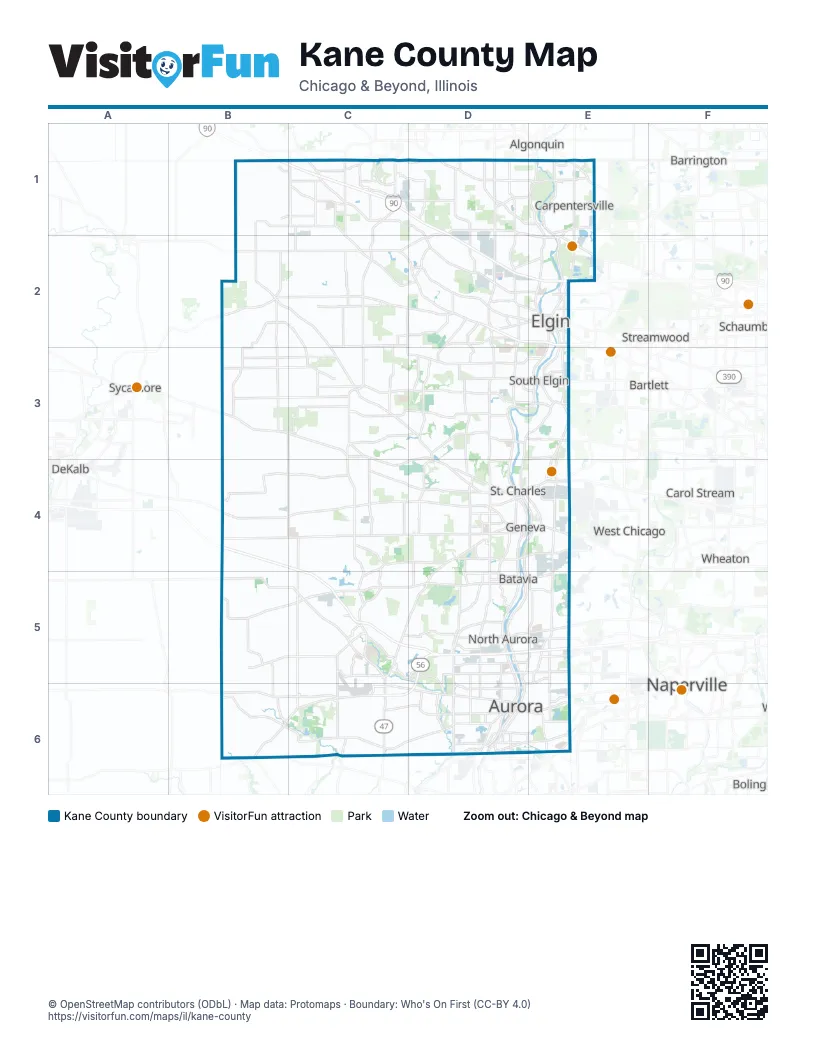
Street index of Kane County
Each street on the sheet and the grid squares it crosses.
- Allen RoadB1, C1, C2
- Jane Addams Memorial TollwayB1, C1, D1, D2, E2
- Big Timber RoadC1, D1, D2, E2
- Brier Hill RoadC1
- U.S. Grant Memorial HighwayC1, C2, D2
- East Higgins RoadD1
- Higgins RoadD1, C2, D2, E2
- Randall RoadD1, D2, D3, D4, D5
- West Higgins RoadD1, E2
- Dundee RoadE1
- East Algonquin RoadE1
- Elgin RoadE1
- Lake Cook RoadE1
- North 8th StreetE1, E2
- North Kennedy DriveE1
- North Western AvenueE1
- Penny AvenueE1, E2
- South Kennedy DriveE1, E2
- South Main StreetE1, B2, C4
- South Western AvenueE1
- West County Line RoadE1
- West Main StreetE1, E2, D4
- Western AvenueE1
- Burlington RoadB2, C2, C3, D3
- French RoadB2
- Main StreetB2, D4, C5, D5
- Plank RoadB2, C2, D2
- West Oak Knoll DriveB2, C2
- West Plank RoadB2
- East Oak Knoll DriveC2
- Oak Knoll DriveC2
- Oak StreetC2, D2
- Damish RoadD2
- Highland AvenueD2
- Larkin AvenueD2, E2
- Martin Luther King Jr Memorial HighwayD2, E2
- Martin Luther King Junior Memorial HighwayD2
- McLean BoulevardD2, D3
- North McLean BoulevardD2
- North Randall RoadD2, D4, D5, D6
- Sleepy Hollow RoadD2
- South McLean BoulevardD2, D3
- South Randall RoadD2, D3, D4, D5
- West Highland AvenueD2, E2
- Bluff City BoulevardE2
- Center StreetE2
- Dundee AvenueE2
- Dwight StreetE2
- East Chicago StreetE2
- East Highland AvenueE2
- East Main StreetE2, D4, E4
- Grace StreetE2
- Illinois AvenueE2
- Kimball StreetE2
- Lavoie AvenueE2
- Lawrence AvenueE2
- North Liberty StreetE2
- North State StreetE2
- Page AvenueE2
- Saint Charles StreetE2, E3
- South 8th StreetE2
- South Liberty StreetE2
- South State StreetE2, E3
- Summit StreetE2
- Villa StreetE2
- McDonald RoadC3, D3
- Bolcum RoadD3
- Bowes RoadD3, E3
- Corron RoadD3
- Hopps RoadD3
- LaFox RoadD3, D4
- North 5th AvenueD3, D4
- Red Gate RoadD3
- Silver Glen RoadD3
- Stearns RoadD3, E3
- West Spring StreetD3, E3
- Dunham RoadE3
- East Middle StreetE3
- East State StreetE3, E4, D5
- Middle StreetE3
- North Kirk RoadE3, E4
- North La Fox StreetE3
- South Gilbert StreetE3
- South La Fox StreetE3
- State Street BridgeE3
- West State StreetE3, D4, D5
- Lincoln HighwayB4, C4, D4
- Ronald Reagan Memorial TollwayB4, C4, C5, D5, E5
- North Main StreetC4
- Bunker RoadD4, D5
- Crissey AvenueD4, E4
- East Fabyan ParkwayD4, E4
- Fabyan ParkwayD4, D5
- Fargo BoulevardD4
- Geneva RoadD4
- Kaneville RoadD4
- Keslinger RoadD4
- North 1st StreetD4
- North 2nd StreetD4
- North Batavia AvenueD4, D5
- North Washington AvenueD4, D5
- Peck RoadD4
- South 1st StreetD4
- South 2nd StreetD4
- South 5th AvenueD4
- South Batavia AvenueD4, D5
- South Peck RoadD4
- South Riverside AvenueD4, E4
- State StreetD4, E4
- West Fabyan ParkwayD4
- West Keslinger RoadD4
- North Bennett StreetE4
- South Bennett StreetE4
- South Kirk RoadE4
- West Roosevelt RoadE4
- Illinois Route 47C5, C6
- Route 47C5
- Aurora AvenueD5, D6
- Batavia AvenueD5
- Butterfield RoadD5, E5
- East Indian Trail RoadD5, E5
- East Wilson StreetD5
- Mooseheart RoadD5
- North Grant StreetD5
- North Lake StreetD5, D6
- North Lincolnway StreetD5
- North River RoadD5
- Orchard RoadD5, D6
- South Lincolnway StreetD5
- South River RoadD5
- South River StreetD5
- West Indian TrailD5
- West Wilson StreetD5
- East Indian TrailE5
- North Farnsworth AvenueE5, E6
- Galena StreetB6
- East Base Line RoadC6, D6
- East Galena BoulevardC6, D6, E6
- Jericho RoadC6, D6
- United States Route 30C6
- East Illinois AvenueD6
- East New York StreetD6, E6
- North BroadwayD6
- South Lake StreetD6
- West Galena BoulevardD6
- West Illinois AvenueD6
- West Lake StreetD6
- West New York StreetD6
- Hill AvenueE6
- North Ohio StreetE6
- Ogden AvenueE6
- West Ogden AvenueE6
Things to do on the Kane County map
Places on the map
- Advocate Sherman Hospital
- Algonquin Commons
- Andersen Park
- Andersen Woods Forest Preserve
- Apple Orchard
- Arlene Shoemaker Forest Preserve
- Aurora
- Aurora Country Club
- Aurora Prairie Park
- Aurora Quarry & Mine
- Aurora Township
- Aurora University
- Aurora West Forest Preserve
- Barnes Forest Preserve
- Bartlett/Dundee Park
- Batavia
- Batavia Apartments
- Batavia High School
- Batavia Township
- Belle Vue Park
- Big Rock
- Big Rock Campground
- Big Rock Forest Preserve
- Big Rock Township
- Binnie Forest Preserve
- Black Sheep Golf Club
- Blackberry Farm
- Blackberry Maples Forest Preserve
- Blackberry Township
- Bliss Woods Forest Preserve
- Bolcum Road Wetlands Forest Preserve
- Bonnie Dundee Golf Club
- Bowes Creek Country Club
- Bowes Creek Greenway
- Bowes Creek Woods Forest Preserve
- Braeburn Marsh Forest Preserve
- Brandywine Circle
- Brewster Creek Circle
- Brewster Creek Forest Preserve
- Bruning Bay
Next to Kane County
- Algonquin
- Barrington
- Bartlett
- Bolingbrook
- Carol Stream
- DeKalb
- Glendale Heights
- Hanover Park
- Lisle
- Naperville
- Roselle
- Schaumburg
- Streamwood
- Sycamore
- West Chicago
- Wheaton
- Winfield
© OpenStreetMap contributors (ODbL) · Map data: Protomaps · Boundary: Who's On First (CC-BY 4.0)