

Illinois map
Mount Prospect map
About 55,460 people live here (Census Bureau, 2024 estimate). The sheet's index lists 300 streets; East Rand Road, South Busse Road and East Central Road cross the most grid squares. Also on it: Kensingson Center, Randhurst Village and Briarwood Lake.
Open the map (PDF, US Letter)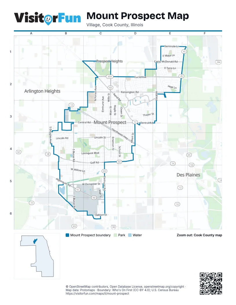
Street index of Mount Prospect
Each street on the sheet and the grid squares it crosses.
- East Euclid AvenueC2, D2, E2
- West Algonquin RoadB5, C5, C6
- West Golf RoadB4, C4, D4
- East Rand RoadB1, C1, C2, D2, D3
- South Elmhurst RoadC4, C5, C6
- North Elmhurst RoadC1, C2
- North River RoadE1, E2
- West Northwest HighwayB3, C3
- South Main StreetC3, C4
- West Lincoln StreetB4, C4
- North Main StreetC2, C3
- East Northwest HighwayC3, C4, D4
- West Euclid AvenueC2
- East Oakton StreetC6
- West Rand RoadC2
- Rand RoadD3
- East Algonquin RoadB5
- East Golf RoadB4
- South Busse RoadB3, B4, B5, B6
- East Central RoadB3, C3, D3, E3
- East Kensington RoadC2, D2, E2
- West Central RoadB3, C3
- West Dempster StreetB5, C5
- North Wolf RoadE2, E3
- South Mount Prospect RoadD3, D4
- East Camp McDonald RoadE1
- West Camp McDonald RoadB1, C1
- Kensington RoadE2
- West Kensington RoadC2
- Schoenbeck RoadC1, C2
- West Oakton StreetC6
- South Wolf RoadE2
- East Prospect AvenueC3, C4, D4
- East Business Center DriveD2, D3
- Feehanville DriveD2, E2, D3
- West Prospect AvenueB3, C3
- North Wheeling RoadD2, D3
- Seminole LaneE1
- North Arthur AvenueB3
- West Lonnquist BoulevardB4, C4
- North Prospect Manor AvenueC2, C3
- East Council TrailC4, D4
- South Emerson StreetC3, C4
- South Hatlen AvenueB3, B4
- South William StreetD3, D4
- South Hi Lusi AvenueC3, C4
- South Wa Pella AvenueC3, C4
- North Elmhurst AvenueC2, C3
- North Forest AvenueC2, C3
- South I Oka AvenueC3, C4
- South Edward StreetD3, D4
- South Albert StreetD3, D4
- South Can-Dota AvenueC3, C4
- South We Go TrailC3, C4
- Burning Bush LaneE1, E2
- South School StreetD3, D4
- Perimeter DriveC2, D2
- East Thayer StreetC3, D3, E3
- East Greenwood DriveD2, E2
- South George StreetD3, D4
- South Louis StreetD3, D4
- North Pine StreetC2, C3
- North Wille StreetC2, C3
- South Owen StreetD3, D4
- South Maple StreetC3, C4
- Westgate RoadD2, D3
- West Willow LaneB5, C5
- Barberry LaneD2, E2
- West Lincoln RoadB4
- North Fairview AvenueC2, C3
- South See-Gwun AvenueC3, C4
- West Busse AvenueB3, C3
- Russel StreetC2, C3
- Ironwood DriveD2
- Eastwood AvenueC2, C3
- West Milburn AvenueB4, C4
- Palm DriveB4, C4, C5
- Dogwood LaneD2, E2
- South Lancaster StreetC3, C4, C5
- West Sunset RoadB4, C4
- South Meier RoadB3, B4
- East Busse AvenueC3, D3
- South Elm StreetC3, C4
- South Wille StreetC3, C4
- East Tano LaneE1, E2
- South Na Wa Ta AvenueC4
- West Isabella StreetC3
- North Emerson StreetC2, C3
- South Pine StreetC3, C4
- Linneman RoadC4, C5
- North Elm StreetC2, C3
- East Henry StreetC3, D3
- North Maple StreetC2, C3
- West Memory LaneC3
- West Gregory StreetC3
- West Evergreen AvenueC3
- East Wood LaneE1
- West Sha Bonee TrailC4
- East Lincoln StreetC4, D4
- Boxwood DriveD2
- West Bonita AvenueB3, B4
- West Huntington Commons RoadC5
- South Douglas AvenueB4
- Randhurst Village DriveC2, D2
- Cedar LaneD2, E2
- West Henry StreetB3, C3
- East Evergreen AvenueC3, D3
- Robert DriveB4, B5
- Catalpa LaneB5
- East Sunset RoadC4, D4
- Park DriveE1
- Briarwood Drive WestB5
- West Thayer StreetB3, C3
- East Maya LaneE1
- Butternut LaneC1
- Heritage DriveE2
- Hopi LaneE2
- South Fern DriveB4, B5
- Cottonwood LaneB5, C5
- Mac Arthur DriveC3
- Terminal DriveB6, C6
- Crystal LaneB5
- South Crestwood LaneB4
- West Chariot CourtB6
- South Linneman RoadC5
- Hemlock LaneD2
- East Milburn AvenueC4, D4
- South Audrey LaneB3, B4
- North School StreetD3
- Cypress DriveC4, C5
- North Owen StreetD3
- West Highland StreetC2
- Marcella RoadD3
- North Stevenson LaneD3
- East Isabella StreetC3, D3
- North Columbine DriveE1, E2
- South Elmhurst AvenueC3, C4
- Forest Cove DriveB5
- South Bobby LaneB3, B4
- West Go Wando AvenueC4
- Center DriveC2
- South Kenilworth AvenueB3, B4
- Birch DriveB4, B5
- Pheasant TrailB5
- West Man-Awa TrailC4
- North Burning Bush LaneE1, E2
- Hunt Club DriveC4, C5
- North Mura LaneE1
- South Edgewood LaneB4
- Briarwood Drive EastB5
- East Gregory StreetC3, D3
- Larch DriveE1
- South Carol LaneB4
- West Rusty DriveB4
- North Meadow LaneC2
- East Emmerson LaneD3, E3
- North Indigo DriveE1, E2
- East Cree LaneE2
- South Wellers LaneB3, B4
- East DriveD2
- Magnola LaneB5
- West Estates DriveB4
- Wall StreetC5, C6
- North Louis StreetD3
- North Lama LaneE1, E2
- East Berkshire LaneC4, D4
- Huntington Commons RoadC5
- North William StreetD3
- Greenfield LaneD2
- Access RoadC2, D2
- East Lonnquist BoulevardC4, D4
- Dale AvenueC1, C3
- South Helena AvenueB3, B4
- South Deborah LaneB4
- Sycamore LaneD2
- Brentwood LaneD2
- Yates LaneE3
- Basswood LaneE2
- South Lavergne DriveB4, B5
- East Lowden LaneD3
- South Waverly PlaceC3, C4
- W Bob O Link RoadC2
- Oneida LaneE1
- Seneca LaneE1
- Juniper LaneD2
- North Waverly PlaceC3
- North Kenilworth AvenueB3
- South Waverly AvenueC4
- West Dresser DriveC3
- Alder LaneD2
- North Wedgewood LaneC2
- Hawthorne CircleC5
- Mount Prospect PlazaD3
- North Picadilly CircleC1
- Crabtree LaneD2
- West Mansard LaneB5, B6
- East Ardyce LaneD3
- North Stratton LaneD3
- North Aralia DriveE1
- West Wimbolton DriveC2
- West Verde DriveB3, B4
- East Ivy LaneE2
- Linden LaneD2
- Boulder DriveE2
- South Tamarack DriveB5
- West Millers RoadC5
- East Highland StreetC2, D2
- South Inner Circle DriveD4
- Persimmon LaneC1, C2
- Horner LaneD3
- East Aztec LaneE1
- North Lancaster StreetC3
- Creekside DriveC2
- West Hiawatha TrailC4
- Kiowa LaneE2
- Gregory StreetC3
- Newberry LaneD2
- North Cathy LaneC3
- Arbor CourtB4
- Centennial DriveD3
- Laurel DriveE1
- South Leonard LaneB3, B4
- West Cleven AvenueB3, C3
- Cannon DriveC6
- East White Oak StreetB4
- Mandel LaneE1
- Oriole LaneC2
- Larkdale LaneC2
- Lexington DriveC6
- Azalea LaneE2
- Bittersweet LaneE2
- East Carib LaneE1
- South Robert DriveB4
- North Oak AvenueC3
- West Locust LaneB5
- North Moki LaneE2
- West Thornwood LaneB5
- Harvest LaneD3
- Woodview DriveE1
- Quince LaneE2
- Malmo DriveC5, C6
- Beechwood DriveB4, B5
- Aspen DriveE1
- Grove DriveB4
- Bishop CourtD2, E2
- South Prairie AvenueB3, B4
- South Tower DriveC4
- South Noah TerraceB4
- Beech RoadE1
- Kenneth DriveB6
- Chestnut DriveB5
- East Yuma LaneE1
- South Marina DriveD4
- West Cathy LaneC3
- Wilshire DriveD2
- Ash DriveB5, C5
- Mulberry LaneD2
- Sumac LaneE2
- East Hiawatha TrailC4, D4
- North Park DriveE1, E2
- West Pendleton PlaceB4, C4
- West Orchard PalceC4
- Addison CourtB6
- East Memory LaneC3
- Ida CourtC5
- West Hatherleigh CourtB5
- Autumn LaneD3
- West Lawrence LaneB4
- East Sitka LaneE1
- Green Acres LaneB4, C4
- Robin LaneB4, C4
- Glenn LaneB4, C4
- West Greenbriar DriveB4
- West Robbie LaneB4
- Wintergreen AvenueE1
- Sable LaneB5
- West Kim AvenueB4
- West Myrtle DriveB4
- East Corktree LaneE2
- Cardinal LaneD3
- Hackberry LaneD2
- East Burr Oak DriveE2
- James DriveB5
- Kennicott PlaceB4
- East Cholo LaneE2
- West Victoria DriveB6
- Highland AvenueD2
- Pawnee LaneE1
- South Nordic RoadC6
- Small LaneD3
- North Peachtree LaneE2
- West Whitegate DriveC3
- Byron CourtC4
- East Garwood AvenueD2
- Enterprise DriveC6
- Apache LaneE2
- Cayuga LaneE1
- Redwood DriveB5
- West Martha LaneB4
- Biermann CourtD2
Places on the map
- 1st Dental & Orthodontist
- Advance Auto Parts
- Aldi
- Angelo Caputo's Fresh Markets
- Aspen Trails Park
- Bank of America
- Big Surf Wave Pool
- Briarwood Lake
- Clearwater Park
- Costco
- Crystal Court
- Euclid Elementary School
- Golf Plaza II
- Golf Plaza Shopping Center
- Gregory Park
- Indian Grove Elementary School
- Kensingson Center
- Kopp Park
- Lincoln Middle School
- Lions Park
- Meadows Park
- Melas Park
- Menards
- Mount Prospect Center
- Mount Prospect Golf Course
- Mount Prospect Plaza
- Mount Prospect Public Library South Branch
- Mt. Prospect Commons
- Old Orchard Country Club
- Plaza United
- Prospect High School
- Randhurst Commons
- Randhurst Village
- Sunrise Park
- Sunset Park
- Sycamore Trails Park
- Tamarack Trails Park
- The UPS Store
- Weller Creek Park
- Woodland Trails Park
Next to Mount Prospect
© OpenStreetMap contributors, Open Database License, openstreetmap.org/copyright · Map data: Protomaps · Boundary: Who's On First (CC-BY 4.0); U.S. Census Bureau















