

Illinois map
Naperville map
About 107,077 people live here (Census Bureau, 2024 estimate). The sheet's index lists 300 streets; Illinois Route 59, Ronald Reagan Memorial Tollway and West Ogden Avenue cross the most grid squares. Things to do inside the boundary: Naper Settlement.
Open the map (PDF, US Letter)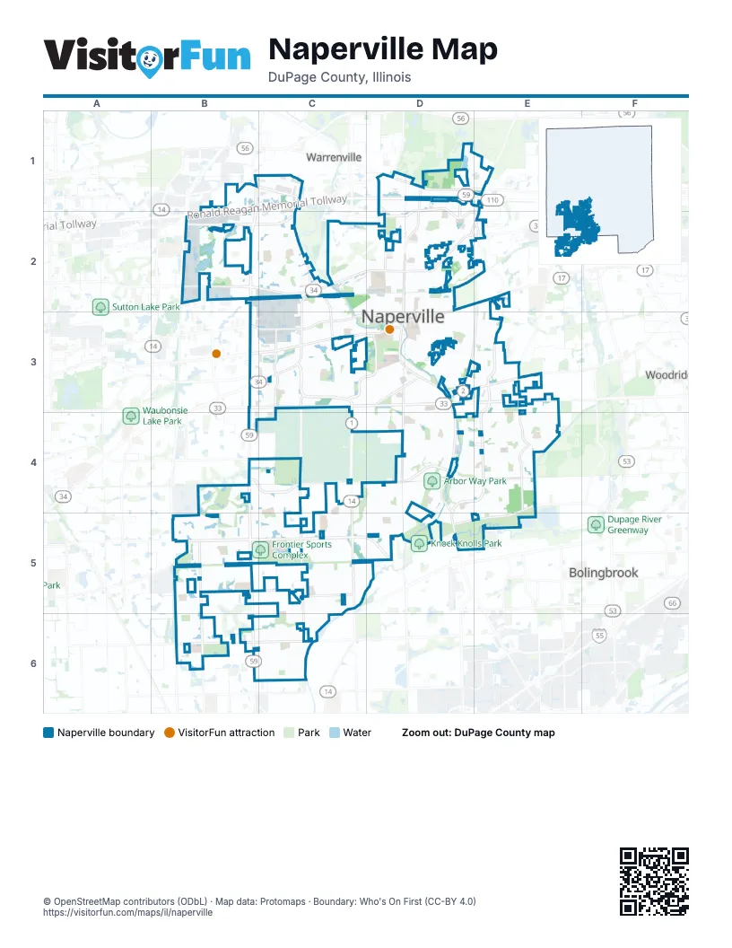
Street index of Naperville
Each street on the sheet and the grid squares it crosses.
- Ronald Reagan Memorial TollwayB1, C1, D1, B2
- Illinois Route 59B1, B2, B3, B4, B5, B6
- West Ogden AvenueC2, D2, B3, C3
- Aurora AvenueB3, C3, D3
- North Aurora RoadB2, C2
- East Ogden AvenueD2, E2
- 75th StreetB3, C3, D3, E3
- 95th StreetB5, C5, D5
- Naper BoulevardE2, E3, D4, E4
- South Washington StreetD2, D3, D4
- Plainfield-Naperville RoadC3, C4, C5
- Warrenville RoadD1, E1
- North Washington StreetD1, D2
- Mill StreetD1, D2
- Raymond DriveC1, C2
- Chicago AvenueD2, E2, D3
- Wehrli RoadE3, E4
- West Ferry RoadB1, C1
- Hobson RoadD3, E3
- Hassert BoulevardB6, C6
- Wolf's Crossing RoadB5
- 111th StreetB6
- Naperville RoadE1, E2
- Freedom DriveD1, D2
- Washington StreetD4, D5
- College RoadE3
- Maple AvenueE2
- Weber RoadD5
- 87th StreetB4, C4, D4, E4
- West Diehl RoadB2, C2, D2
- West StreetD2, C3, D3
- 248th AvenueB5, B6
- Rickert DriveC3
- Book RoadC3, C4, C5, C6
- West Jefferson AvenueB3, C3, D3
- East Diehl RoadD1, E1, D2, E2
- Modaff RoadD3, D4, D5
- Fort Hill DriveC2, C3
- South River RoadC3
- Olesen DriveE2, D3, E3
- Royce RoadE4, D5, E5
- 103rd StreetB5, C5
- West Gartner RoadC3, D3
- Lisson RoadE4
- 104th StreetC5
- Ferry RoadB1
- North Naperville Wheaton RoadD2, E2
- North River RoadC2, C3
- River RoadC2
- Herrick RoadD1
- Montgomery RoadB4
- McCoy DriveB3
- West Bailey RoadC4, D4
- Gateshead DriveC5, D5
- Knoch Knolls RoadD4, D5
- East Bailey RoadD4, E4
- West Bauer RoadC2, D2
- Leverenz RoadB4, C4, B5, C5
- Fairway DriveB2
- East Gartner RoadD3, E3
- Skylane DriveC4, C5
- South Whispering Hills DriveC3
- Clearwater LaneC5, C6
- Brookdale RoadB2, C2
- Clyde DriveD3, D4
- White Eagle DriveB4
- Shuman BoulevardD1
- Newport DriveD4, D5
- North Loomis StreetD2
- Oswego RoadC3, D3
- Ranchview DriveE3, E4
- South Charles AvenueD2, D3
- Frontenac RoadB2
- Beebe DriveC3, B4, C4
- North Webster StreetD2
- Deering Bay DriveB4, B5
- Royal Saint George DriveC2, D2
- North Eagle StreetD2
- Honey Locust DriveB5, B6
- Mistflower LaneB5
- Conan Doyle RoadC5
- Chinaberry LaneB5, B6
- University DriveE4
- Sanctuary LaneC3
- Auburn AvenueE4
- Bond StreetB2, C2
- Falkner DriveC5
- Terrance DriveD3, D4
- Douglas AvenueC2, D2, C3
- East Hillside RoadD3
- Tupelo DriveD3
- Country Club BoulevardB2
- Sassafras LaneB5, B6
- Canyon Run RoadE4
- Tall Grass DriveB5
- Sequoia RoadC3
- South Wright StreetD2, D3
- Rosinweed LaneC6
- South Julian StreetD2, D3
- Dupahze StreetD5
- River Woods DriveD4, E4, D5
- Killdeer DriveD3, D4
- Springdale CircleC5
- Arlington AvenueD4, E4
- Timber Creek LaneC5, D5
- East Benton AvenueD2
- Chesapeake LaneB5
- River Oak DriveE4
- Champion RoadB6, C6
- East Bauer RoadD2
- Heatherton DriveC2
- Weatherbee LaneD1, E1
- South Sleight StreetD2, D3
- Chevy Chase LaneB5
- East North AvenueD2
- Columbia StreetD2
- Hyde Park LaneE3, E4
- Plank RoadD2
- McDowell RoadB2, C2
- West 5th AvenueC2, D2
- Culpepper DriveE3
- High Meadow RoadB6, C6
- Hobson Mill DriveD3
- North Main StreetD2
- Prairie Knoll DriveD4
- Commons RoadC2, D2
- Waxwing AvenueD3, D4
- Idlewild LaneB5
- Corporate LaneC1
- 83rd StreetB4, C4
- Alexandria DriveD4, E4
- Buttonwood CircleC3
- Lawrence DriveC5
- Coach DriveD4
- 77th StreetE3, E4
- Ring RoadD4
- Chippewa DriveD2
- Feldott LaneC3
- West Benton AvenueC2, D2
- Shore RoadB2
- North Brainard StreetD2
- Westglen DriveD4
- South Loomis StreetD2, D3
- Breckenridge LaneC5, D5
- Redstart RoadD4
- Lucent LaneD1
- Switch Grass LaneC6
- Chokeberry DriveC6
- Flock AvenueD4
- Birch LaneB5
- Keim RoadE4, E5
- Whirlaway AvenueD3
- Country Lakes DriveB2
- Johnson DriveD3, E3
- Jackson AvenueC3, D3
- Elizabeth AvenueD3, E3
- Tamarack AvenueD3
- North Sleight StreetD2
- Jane AvenueD3, E3
- Cedarbrook RoadD4
- Fawn Lake CircleB4
- Chantecleer LakesC2
- Pam Davis DriveD3
- Westings AvenueB1, C1
- Edgewater DriveD3
- Grassmere RoadB5
- Prairie AvenueD3
- Three Farms AvenueC3
- Elmwood DriveD3
- Iroquois AvenueD2
- Bayou Path DriveB2
- Millcreek LaneE3
- Hunter CircleE3
- Thornapple DriveC3
- Prairie Sage LaneC6
- Shumard LaneB6
- Willow Ridge DriveC5
- High Grove LaneB2, C2, B3
- Knoll DriveE4
- Bainbridge DriveC2
- Snapjack CircleC6
- North Ellsworth StreetD2
- Gleneagles DriveD4, D5
- Muirhead AvenueE3, E4
- East 5th AvenueD2
- Cassin RoadD4, E4
- Century Farm LaneC2, D2
- Springhill CircleD2
- Wild Timothy RoadC6
- Emerald DriveD3
- 91st StreetE4, B5
- Catalpa LaneD3
- Swallow StreetD3, D4
- South Columbia StreetD2, D3
- Huntleigh DriveD3, E3
- Joyce LaneC5
- Teak CircleB5, B6
- Dilorenzo DriveD4, E4
- Cedar DriveB6
- De Lasalle AvenueD5
- Remington DriveE4
- Park StreetD1, D2
- Olympus DriveD3, D4
- Lapp LaneB5
- Wicklow RoadC5
- Whitehall LaneC4
- East School StreetD2
- Rollingridge RoadB5
- Forest Creek LaneC5, D5
- South Main StreetD2, D3
- Sunnybrook DriveC2, C3
- Cedar Glade RoadC4, C5
- Redfield RoadC2
- Apache DriveD2
- Basin Trail LaneB2
- Lakewood CircleC3
- Flambeau DriveC4
- Foxboro LaneC4
- Oxford LaneD3, D4
- East Porter AvenueD3
- Ambleside CircleC3
- Caine DriveC5
- Freeland CircleB6, C6
- Fender RoadE4
- Huntington CircleE2
- Ada LaneC3
- North Charles StreetD2
- Watkins LaneC3
- South Brainard StreetD2, D3
- Falcon DriveC5
- Haider AvenueC5
- Tuthill RoadE2
- Westminster DriveC2
- Countryside CircleD4
- Showplace DriveB5
- Robin Hill DriveD3
- Fesseneva LaneC6
- Emerson LaneC3
- Hamilton LaneE3
- Audrey AvenueB3, C3
- Edward RoadD3, E3
- South Webster StreetD2, D3
- Ivy LaneC2
- Robert LaneC5
- Empress DriveB5
- Greenwood CircleB2
- Westbrook CircleD4
- Seiler DriveD5
- Monticello DriveD2
- Spring AvenueD2
- Templar DriveD4
- Burning Tree LaneC2, D2
- Benedetti DriveC2, D2
- South Birchwood DriveC3
- Warwick DriveD4, E4
- Briergate DriveC2
- Hinterlong LaneC2
- Breitwieser LaneB5
- Hillsboro LaneC4
- Martello AlleyC3
- East 8th AvenueD2
- Oakton LaneC3
- Sara LaneE4
- Claremont DriveC2, C3
- Augustana DriveE4
- Eagle Brook DriveD5
- Hamlet RoadC5
- Rock Spring RoadC4, D4
- Rosecroft LaneB5
- Esquire CircleC5, C6
- North Wright StreetD2
- Stanford DriveE4
- Rutland RoadB4, C4
- East Franklin AvenueD2
- Gowdey RoadB2, C2
- Kilburne LaneC5
- Celeste LaneC5
- Riparian DriveD4
- Warm Springs LaneC5
- Thatcher DriveC6
- East Iroquois AvenueD2
- West Hillside RoadD3
- La Fox AvenueB3, C3
- Raintree DriveC3
- Wendy DriveD4, C5, D5
- Warbler DriveD4
- West Franklin AvenueD2
- Spindletree AvenueE4
- Spartina RoadC6
- Lexington LaneC3
- Sheehan DriveB4, C4
- Quincy AvenueC2
- Pontiac CircleD4
- Scottsdale CircleB4, B5
- Dunrobin RoadE3
- Cobblebrook LaneE3, E4
- Sycamore DriveD3
- Worthing DriveD4
- Basswood DriveD3
- Mandeville LaneC5
Things to do on the Naperville map
Places on the map
- Arbor Way Park
- Block 59
- Brighton Ridge Commons
- Centennial Park
- Clow Creek Greenway
- Commissioners Park
- Country Lakes Park
- Cress Creek Country Club
- Cress Creek Square
- Design Pointe
- Downtown Naperville
- DuPage River Park
- Eastgate Crossing
- Edward Hospital
- Electric Service Center
- Fox River Commons
- Fox Run Square
- Freedom Commons
- Frontier Sports Complex
- High Grove Plaza
- Iroquois Center
- Knoch Knolls Disc Golf Course
- Knoch Park
- Knock Knolls Park
- Lake Birkett
- Lake Osborne
- Lincoln Greenway
- Market Meadows
- May Watts Park
- Naper West Plaza
- Naperville Crossings
- Naperville Historic District
- Naperville North High School
- Naperville Office Park
- Naperville Plaza
- Pioneer Park Forest Preserve
- Springbrook Parkway
- West Ridge Court
- Wheatland Township
- White Eagle Golf Club
Next to Naperville
© OpenStreetMap contributors, Open Database License, openstreetmap.org/copyright · Map data: Protomaps · Boundary: Who's On First (CC-BY 4.0); U.S. Census Bureau















