

Illinois map
Rockford map
About 169,120 people live here (Census Bureau, 2024 estimate). The sheet's index lists 300 streets; U.S. Grant Memorial Highway, East State Street and West State Street cross the most grid squares. Things to do inside the boundary: Anderson Japanese Gardens and Rockford Art Museum.
Open the map (PDF, US Letter)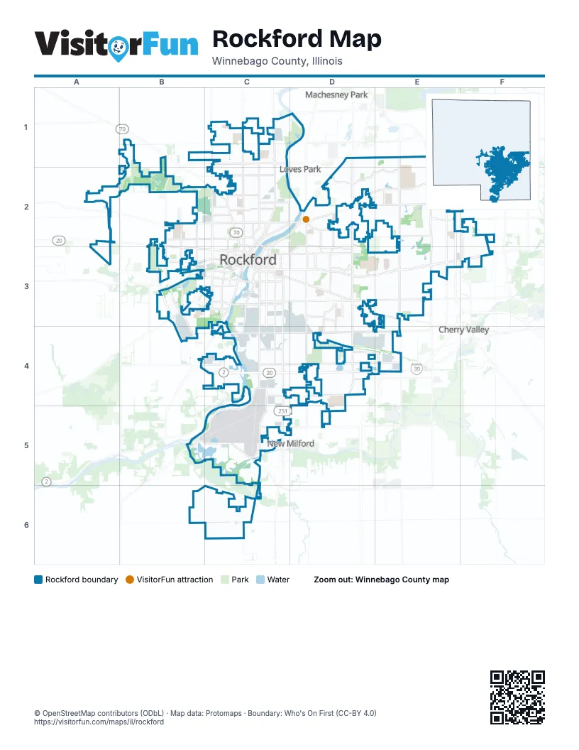
Street index of Rockford
Each street on the sheet and the grid squares it crosses.
- U.S. Grant Memorial HighwayA3, B3, B4, C4, D4, E4
- Jane Addams Memorial TollwayE2, E3
- East State StreetC3, D3, E3, F3
- Harrison AvenueC4, D4, E4
- 11th StreetC3, C4, C5
- North Alpine RoadD1, D2, D3
- West State StreetA2, B2, B3, C3
- South Main StreetC3, C4
- North 2nd StreetC2, D2, C3
- North Main StreetC1, C2, C3
- East Riverside BoulevardD1, E1, F1
- Kishwaukee StreetC3, C4
- South Springfield RoadB3, B4, C4
- Kilburn AvenueC2, C3
- North Bell School RoadE1, E2, E3
- West Riverside BoulevardC1
- North Church StreetC1, C2, C3
- Chestnut StreetB3, C3
- West Jefferson StreetB2, C2, C3
- North Lyford RoadF2, F3
- North Springfield AvenueB2
- Mercy WayF1, F2
- West Harrison AvenueC4
- Cedar StreetC3
- North Longwood StreetC2, C3
- South Church StreetC3
- 1st AvenueC3
- Park AvenueC3
- South Springfield AvenueB2, B3
- John StreetC2
- East Jefferson StreetC3
- North 3rd StreetC3
- South Wyman StreetC3
- Walnut StreetC3
- Jefferson StreetC3
- North Wyman StreetC3
- West State RoadC3
- South Longwood StreetC3
- South Lyford RoadF3
- North Perryville RoadE1, E2, E3
- South Alpine RoadD3, D4
- Spring Creek RoadD2, E2
- Charles StreetC3, D3, E3
- Auburn StreetA2, B2, C2, D2
- North Rockton AvenueC1, C2, C3
- BroadwayC3, D3
- Newburg RoadD3, E3
- School StreetB2, C2
- 15th AvenueC3, D3
- South Central AvenueC3, C4
- North Winnebago StreetC2, C3
- North Central AvenueC2, C3
- South 6th StreetC3, C4
- Rote RoadE2, F2
- Morgan StreetB3, C3
- Whitman StreetC2, C3
- Owen Center RoadC1
- South Perryville RoadE3
- Montague RoadB3, C3
- 5th AvenueC3, D3
- North Meridian RoadA1, A2
- South Winnebago StreetC3
- Michigan AvenueC3
- Parkside DriveD3
- South Bell School RoadE3
- Lyford RoadF2, F3
- Bauer ParkwayC1
- College AvenueC3
- North 6th StreetC3
- Marchesano DriveC3
- Bauer BridgeC1, D1
- North 9th StreetC3
- Rockton AvenueC2, C3
- Center TerraceD3
- State StreetC3
- North Mulford RoadE1, E2, E3
- .Guilford RoadD2, E2, D3
- Sandy Hollow RoadC4, D4, E4
- South Mulford RoadE3, E4
- 9th StreetC3, C4, C5
- 20th StreetD3, D4
- Spring Brook RoadD2, E2, F2
- Harlem BoulevardC2, D2
- Huffman BoulevardC1, C2
- Rural StreetC3, D3
- Samuelson RoadC4, D4
- Pepper DriveD2, E2
- Falcon DriveC4, C5
- Beltline RoadB5, C5
- Forest Hills RoadD1, D2
- Ridge AvenueC2
- McFarland RoadE1, E2
- Halsted RoadC2
- Safford RoadA2, B2, C2
- Seminary StreetC3, C4
- Kishwaukee RoadB5, C5
- South Pierpont AvenueB3
- Preston StreetB3, C3
- Fairview AvenueB2, C2, D3
- Fulton AvenueC2, D2
- 23rd AvenueC3, D3, C4
- Airport DriveC4, C5
- Linden RoadD4
- Custer AvenueC2
- Highcrest RoadD2
- East Gate ParkwayD3
- Montague StreetB3, C3
- Brooke RoadC4
- Colorado AvenueD3, D4
- Blackhawk RoadC5, D5
- Glenwood AvenueC2
- Shaw Woods DriveE2
- Ohio ParkwayD3, D4
- American RoadD4, E4
- Fairview BoulevardD3
- Clifton AvenueC3
- Wesleyan AvenueD3
- North Johnston AvenueB2, B3
- Westchester DriveD2, D3
- Parkview AvenueD2, D3
- Calvin Park Boulevard NorthD3
- Daisyfield RoadB3
- Ogilby RoadB3, C3
- North Prospect StreetC2, C3, D3
- Simpson RoadB4, C4
- Olde Creek RoadE2
- Eastmoreland AvenueD3
- South Johnston AvenueB3
- Cunningham StreetC3
- North Madison StreetC2, C3
- 39th AvenueC4
- Morsay DriveD3
- North Pierpont AvenueB2, B3
- Chelsea AvenueD2, D3
- Cumberland StreetC2, D2
- North Avon StreetC2, C3
- Corbin StreetC3
- Liberty DriveC2
- Gilbert AvenueC2
- South Avon StreetC3
- Summit StreetC3
- Welty AvenueD3
- Southrock DriveC4
- Locust StreetC2, C3
- North AvenueC2
- South Rockford AvenueD3
- Sauk LaneC4
- Minnesota DriveD3
- Prairie RoadC4
- South 2nd StreetC3
- South Madison StreetC3
- Y BoulevardC2
- Maray DriveD3
- Peter AvenueD3
- Cunningham RoadB3, C3
- Dawes RoadC4
- Lynmar CourtD3
- Curve StreetC3
- River LaneD2
- Alpine RoadD4
- Frontage RoadC1, C2, C4, C5
- Elmwood RoadC1, D1
- 8th StreetC3, C4, C5
- Crosby StreetC3, D3
- 18th AvenueC3, D3
- North Court StreetC1, C2, C3
- 16th AvenueC3, D3
- 7th StreetC3, C4
- 10th StreetC3, C4, C5
- Elm StreetB3, C3
- East Edson RoadB6, C6
- Latham StreetC1, C2
- Mulberry StreetB2, C3
- 18th StreetD3, D4
- Green StreetB3, C3
- Reid Farm RoadE2
- 12th AvenueC3, D3
- Greenwood AvenueC3, D3
- 22nd StreetD3, D4
- Jackson StreetC3, D3
- South 4th StreetC3, C4
- Arnold AvenueE3, E4
- 10th AvenueC3, D3
- 17th AvenueC3, D3
- South 5th StreetC3, C4
- South Trainer RoadE3
- North Trainer RoadE1, E2, E3
- Ashland AvenueB2, C2
- 16th StreetD3, D4
- Andrews StreetB2, C2
- 15th StreetD3, D4
- Loomis StreetB3, C3
- 17th StreetD3, D4
- 35th StreetD4, D5
- Brendenwood RoadD2
- Sawyer RoadC4, D4
- Paladin ParkwayF1, F2
- 23rd StreetD3, D4
- 12th StreetC3
- Applewood LaneE1, E2
- Grant AvenueC1, C2
- 9th AvenueC3, D3
- 19th StreetD3, D4
- Van Wie AvenueC2, D2
- Arthur AvenueB2, C2
- 20th AvenueC3, D3
- Reed AvenueC4, D4
- 2nd AvenueC3, D3
- Garrett LaneE3
- 6th AvenueC3, D3
- Yonge StreetC2
- Brown AvenueC2, D2
- Sherman AvenueB2, C2
- Rose AvenueC3
- University DriveF2, F3
- Sinnissippi Park/golf CourseC2, D2
- 8th AvenueC3, D3
- North Horsman StreetC2, C3
- South Bend RoadC5, C6
- Blaisdell StreetB2, C2
- Landstrom RoadD2
- James AvenueD2, D3
- 25th StreetD3, D4
- Shiloh RoadE2, E3
- Clover AvenueC3
- Strathmoor DriveE3
- 22nd AvenueC3
- Easton ParkwayD3
- Embury DriveC1
- 7th AvenueC3, D3
- Parmele StreetC3
- Pelley RoadB4, C4
- 24th StreetD3, D4
- Woodruff AvenueC3, D3
- Forest View AvenueD3, E3
- Lockwood In-Park RoadB2, C2
- Fincham DriveE3
- Meadows CircleE3
- Overdene AvenueC2
- Rockford College DriveD3, E3
- Argus DriveE3
- Barnum RoadC4
- Rock Valley CollegeE2
- 13th StreetC3, D3
- Pierce AvenueC2
- Belmont BoulevardC2
- West StreetC3
- Alton AvenueC4, D4
- Lapey StreetC4
- Bildahl StreetC4
- 14th StreetD3
- 4th AvenueC3, D3
- Featherstone RoadE2, E3
- 21st StreetD3, D4
- Burrmont RoadD2
- Jonathan AvenueC2
- Burton StreetC2
- Midway DriveC2
- Wills AvenueC4, D4
- Douglas StreetC2
- Phelps AvenueE3
- 13th AvenueC3, D3
- 29th StreetD3
- Camp Elmwood RoadC5
- 21st AvenueC3, D3
- Jonquil PlaceD2, E2
- Roxbury RoadE3
- Bradley RoadD2
- Barton BoulevardC2
- Palo Verde DriveE1
- Sunnyside DriveD2
- Vernon StreetC2
- 19th AvenueD3
- Concord AvenueB3
- Buckingham DriveD2
- Kent StreetC3
- Sage DriveD1, D2
- Mill RoadE3
- 11th AvenueC3, D3
- Sandhutton AvenueE3, E4
- Oakley AvenueC2, C3
- Weaver RoadE1
- Cessna DriveC5
- Seward AvenueD3, D4
- Larson AvenueD3
- North 1st StreetC2, C3
- North Willard AvenueB2, B3
- Edgemont StreetC2
- Holland StreetC3
- Brookview RoadD2, E2
- South Horace AvenueB3
- Lawndale AvenueC2
- Winthrop LaneD2, D3
- Paris AvenueD2, D3
- North Day AvenueB2, B3
- Lexington AvenueB3
- North Independence AvenueC2, C3
- Parkside AvenueB2, C2
- Sentinel RoadE2
- North Rockford AvenueD2, D3
Things to do on the Rockford map
Places on the map
- Abraham Lincoln Middle School
- Aldeen Golf Club
- Aldeen Park
- Alpine Hills Adventure Park
- Alpine Park
- Alpine Village
- Anna Page Park
- Auburn High School
- Bell Bowl Prairie
- Blackhawk Park
- Chicago Rockford International Airport
- Clarence Hick Sports Complex
- Disc Golf Course East
- Disc Golf Course West
- Greenwood Cemetery
- Guilford High School
- Ingersoll Golf Course
- Klehm Arboretum and Botanic Garden
- Leavings Park Rec Path
- Levings Lake
- Levings Lake Park and Standfield Beach
- Lockwood Park
- Luther Center
- Mercyhealth Sportscore One
- Montague Island
- Mulford Quarry Number 139
- North Main Manor
- Northwest Cargo
- RESA Middle School
- River Bluff Nursing Home
- Rockford Country Club
- Saint Anthony Medical Center
- Sandy Hollow Golf Course
- Searls Park
- Searls Park Prairie Nature Reserve
- Sinnissippi Golf Course
- Spring Lake
- UW Health North Bell School
- UW Health Women and Children's Hospital
- West Cargo
Next to Rockford
- Cherry Valley
- Loves Park
- Machesney Park
- New Milford
© OpenStreetMap contributors, Open Database License, openstreetmap.org/copyright · Map data: Protomaps · Boundary: Who's On First (CC-BY 4.0); U.S. Census Bureau