

Illinois map
Winnebago County map
About 283,790 people live here (Census Bureau, 2024 estimate). The sheet's index lists 132 streets; Jane Addams Memorial Tollway, U.S. Grant Memorial Highway and North 2nd Street cross the most grid squares. Things to do inside the boundary: Anderson Japanese Gardens.
Open the map (PDF, US Letter)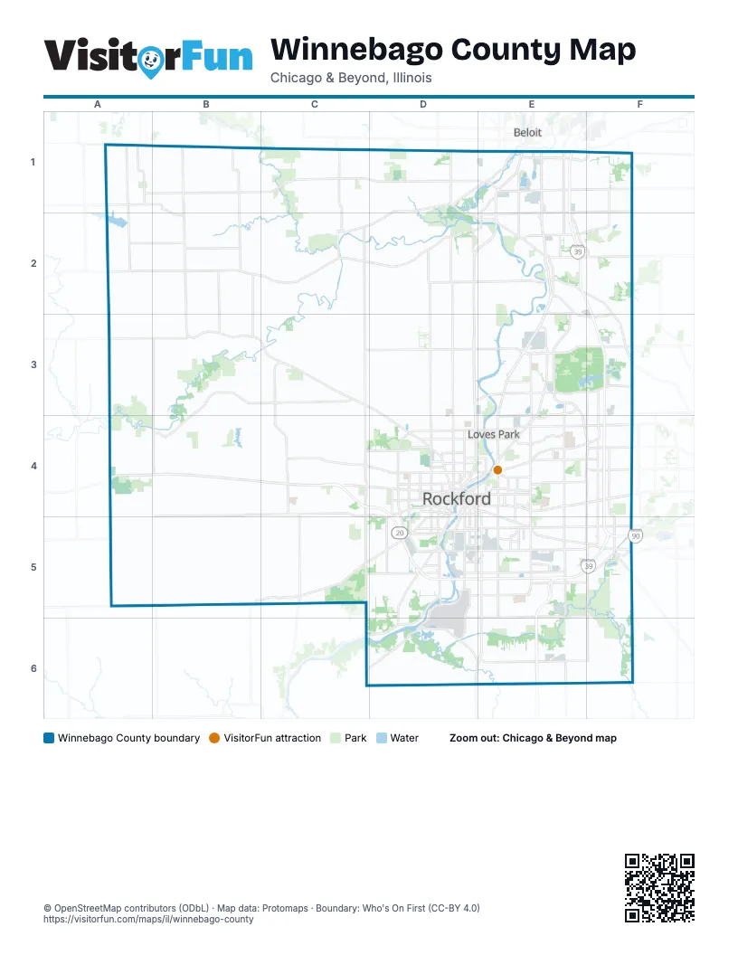
Street index of Winnebago County
Each street on the sheet and the grid squares it crosses.
- Anderson RoadA1
- East Rock Grove RoadA1
- Rock Grove RoadA1, B1, B2
- Rockton RoadD1, D2
- Shirland RoadD1, C2, D2
- West Rockton RoadD1, E2
- Blackhawk BoulevardE1
- Dearborn StreetE1
- East Rockton RoadE1, E2
- Gardner StreetE1
- Jane Addams Memorial TollwayE1, E2, F2, F3, F4, F5
- North 2nd StreetE1, E2, E3, D4, E4
- North Blackhawk BoulevardE1, C2, E2
- State StreetE1, D4, F5
- Freeport RoadA2, B2, C2, D2
- Center RoadB2, B3
- North Center StreetB2
- South Center RoadB2
- South Center StreetB2
- Mitchell StreetC2
- North Meridian RoadC2, C3, C4
- West Winslow RoadC2
- Owen Center RoadD2, D3, D4
- Roscoe RoadD2, E2
- South Blackhawk BoulevardD2, E2
- Wagon Wheel RoadD2
- West Union StreetD2, E2
- Belvidere RoadE2, F2, F3
- Bridge StreetE2
- East Main StreetE2
- East Union StreetE2
- Elevator RoadE2, F2
- Hononegah RoadE2
- North Perryville RoadE2, E3, E4, F4
- Swanson RoadE2, E3, F3
- Hunter RoadF2
- East Cedarville RoadA3
- Trask Bridge RoadA3, B3, C3
- North Pecatonica RoadB3, B4, B5
- Kilburn AvenueC3, D3, D4
- Latham RoadC3, D3, E3
- North Winnebago RoadC3, C4
- Bauer ParkwayD3, E3
- Bauer BridgeE3
- Harlem RoadE3, F3
- North Alpine RoadE3, E4
- Perryville RoadE3
- Ralston RoadE3
- West Lane RoadE3, F3
- Argyle RoadF3, F4
- Main StreetF3, B4
- State Route 173F3
- U.S. Grant Memorial HighwayA4, C4, D4, D5, E5, F5
- West State RoadA4, B4, C4, D4
- Cunningham RoadB4, C4, D4, C5, D5
- South Pecatonica RoadB4
- Auburn StreetC4, D4, E4
- East Cunningham RoadC4
- North Elida StreetC4
- South Elida StreetC4
- South Meridian RoadC4, C5, C6
- West State StreetC4, D4
- Westfield RoadC4, C5
- 1st AvenueD4
- 5th AvenueD4, E4
- Cedar StreetD4
- Charles StreetD4, E4, E5, F5
- Chestnut StreetD4
- College AvenueD4
- East Jefferson StreetD4
- East State StreetD4, E4, F4, F5
- Jefferson StreetD4
- John StreetD4
- Kishwaukee StreetD4, D5
- Morgan StreetD4
- N Main StreetD4
- North 3rd StreetD4
- North 6th StreetD4
- North 9th StreetD4
- North Central AvenueD4
- North Church StreetD4
- North Longwood StreetD4
- North Main StreetD4
- North Rockton AvenueD4
- North Springfield AvenueD4
- North Winnebago StreetD4
- North Wyman StreetD4
- Park AvenueD4
- Rockton AvenueD4
- School StreetD4
- South 6th StreetD4
- South Central AvenueD4, D5
- South Church StreetD4
- South Longwood StreetD4
- South Main StreetD4, D5
- South Springfield AvenueD4
- South Springfield RoadD4, D5
- South Winnebago StreetD4
- South Wyman StreetD4
- Walnut StreetD4, F5
- West Jefferson StreetD4
- West Riverside BoulevardD4, E4
- Whitman StreetD4
- 11th StreetE4, E5, D6, E6
- East Riverside BoulevardE4, F4
- South Alpine RoadE4, E5
- Spring Creek RoadE4, F4
- Lyford RoadF4
- Mill RoadF4, F5
- North Bell School RoadF4
- North State StreetF4
- Rote RoadF4
- South Bell School RoadF4, F5
- South Perryville RoadF4, F5
- West Montague RoadA5, B5
- East Montague RoadB5
- Montague RoadB5, C5, D5
- Montaquue RoadB5
- Simpson RoadC5, D5
- 15th AvenueD5, E5
- Harrison AvenueD5, E5, F5
- Marchesano DriveD5
- Michigan AvenueD5
- South Main RoadD5, C6, D6
- West Harrison AvenueD5
- BroadwayE5
- Center TerraceE5
- Newburg RoadE5, F5
- Parkside DriveE5
- Elgin StreetF5
- Genoa RoadF5
- Genoa StreetF5
Things to do on the Winnebago County map
Places on the map
- Aldeen Golf Club
- Aldeen Park
- Alpine Crest
- Alpine Hills Adventure Park
- Alpine Manor
- Alpine Park
- Alpine Village
- Anna Page Park
- Atwood Homestead
- Auburn High School
- Auburn Manor
- Behr Iron and Metal
- Bell Bowl Prairie
- Bellshire East
- Beverly Park
- Black Trail
- Blackhawk Farms Raceway
- Blackhawk Park
- Blackhawk Springs Forest Preserve
- Blackhawk Valley Campground
- Blue Path
- Blue Trail
- Boney Island
- Boylan Terrace
- BreckenRidge
- Briar Crest
- Burr Oak Valley
- Burritt Township
- Calvary Cemetery
- Calvin and Sophia Ferguson Forest Preserve
- Calvin Park Hills
- Carl & Myrna Nygren Wetland
- Central Park
- Cherry Valley
- Cherry Valley Township
- Cherryvale Mall
- Chicago Rockford International Airport
- Clarence Hick Sports Complex
- Clayton Andrews Forest Preserve
- Coleman Yards Redevelopment
Next to Winnebago County
- Beloit
© OpenStreetMap contributors (ODbL) · Map data: Protomaps · Boundary: Who's On First (CC-BY 4.0)