

Illinois map
Romeoville map
About 41,177 people live here (Census Bureau, 2024 estimate). The sheet's index lists 300 streets; Independence Boulevard, Weber Road and Normantown Road cross the most grid squares. Also on it: Mistwood Golf Course, O'Hara Woods Nature Preserve and Romeoville Prairie Nature Preserve.
Open the map (PDF, US Letter)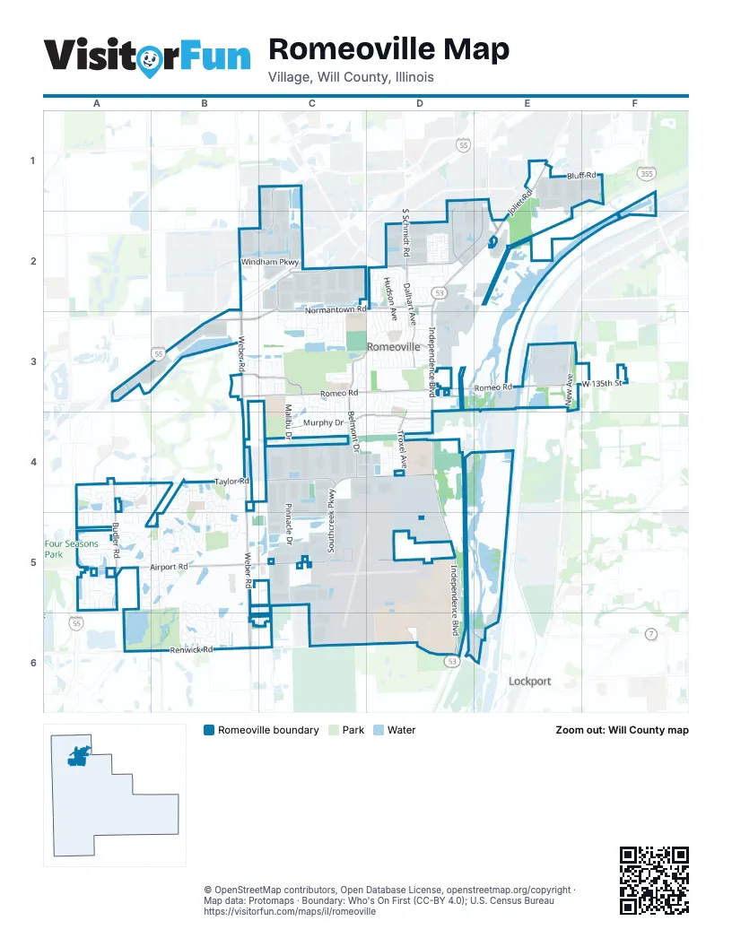
Street index of Romeoville
Each street on the sheet and the grid squares it crosses.
- Des Plaines River Valley BridgeF1, F2
- Independence BoulevardD2, E2, D3, D4, D5, D6
- Joliet RoadE1, E2
- South Bolingbrook DriveE1, E2
- Weber RoadB2, B3, B4, B5, B6
- Normantown RoadC2, D2, A3, B3, C3
- Taylor RoadA4, B4, C4, D4
- Airport RoadA5, B5, C5, D5
- West Romeo RoadB3, C3, D3
- East Romeo RoadD3, E3
- Dalhart AvenueD2, D3
- Southcreek ParkwayC4, C5
- New AvenueE3
- Veterans ParkwayD2
- West 9th StreetD6
- Belmont DriveC3, D3, C4
- Renwick RoadA6, B6, C6, D6
- Murphy DriveC4, D4
- Southeast Frontage RoadC2, A4, A5
- Budler RoadA4, A5
- Grand BoulevardB3, C3
- Naperville DriveE1, D2, E2
- Crossroads ParkwayE1, C2
- Remington BoulevardC1, B2, C2
- Troxel AvenueD3, D4
- West 135th StreetA3, E3, F3
- Enterprise DriveD1, D2
- South Schmidt RoadD2
- Gaylord RoadB6
- South Budler RoadA4
- Pinnacle DriveC4, C5
- Montrose DriveD2, D3
- Richfield TrailA5, B5
- High RoadE3
- Bluff RoadE1, F1
- Weslake ParkwayA4
- George Michas DriveD5, D6
- South Highpoint DriveB4, B5
- Lakeview DriveB2, C2
- Hudson AvenueD2, D3
- Grand Haven CircleB6
- Glen AvenueD3
- Windham ParkwayB2, C2
- Fenton AvenueD3
- Kingston DriveD2, D3
- Arlington DriveD3
- Wesglen ParkwayB4, B5
- Honeytree DriveD2
- Sierra TrailA5, B5
- Benzie CircleB5, B6
- Frieh DriveC3
- Ambassador AvenueD2
- Lakeside DriveD1, D2, B4
- Abbeywood DriveD2
- Dartmoor AvenueD4
- Cadillac CircleB6
- Haller AvenueD4
- Healy AvenueD4
- Geneva AvenueD2
- Tallman AvenueD4
- Lot GGD5
- Birch LaneC2, C3
- Grand Haven RoadB6
- Fiddyment DriveA5, B5
- Hamrick AvenueC4, D4
- Wedgeport CircleA4, A5
- Macon AvenueC3, D3, C4
- Arborwood CircleB4
- Hemlock AvenueD3, D4
- Hickory AvenueD3, D4
- Zinnia DriveB5
- Malibu DriveC3, C4
- Farragut AvenueD2
- Kentland DriveA4
- Laurel AvenueD3
- Lake Shore DriveA4, A5
- Ontario DriveC3
- University East DriveD5
- William DriveA5, B5
- McKool AvenueD3
- Stonebrook DriveA5
- Six Pines DriveD2
- Everette AvenueD3
- Camden AvenueD3
- Helen DriveA5
- Dollinger DriveA5
- Wedgewood CircleA5
- Chicago Tube DriveC5
- North Sleepy Hollow LaneD2
- Greenwood AvenueD3
- Fremont AvenueC3, C4
- Rocbaar DriveD2, E2
- Gavin AvenueC3, C4
- South Frontage RoadC2
- Marquette DriveD1, E1
- Whitmore DriveA5
- Kenyon AvenueD3
- Azalea CircleB5
- Anderson DriveD3
- Maggie LaneC3
- Richmond DriveA5
- Wilco BlvdD5, D6
- Forestwood DriveE2, D3
- Ludington CircleB5, B6
- Anna LaneC3
- Material RoadD4
- Tuscany LaneA5
- Arnold AvenueC3
- Trafalger DriveA5
- North Misty Ridge DriveD2
- Honeysuckle DriveB5
- Hayes AvenueD3
- Lot NND5
- Princeton AvenueC3
- Rogers RoadD2
- Beacon AvenueD2
- Ashbrooke RoadA5
- Spangler RoadD3, D4
- Grand Haven BoulevardB6
- Karen AvenueD3
- Spangler AvenueD3
- Zachary DriveB6
- Berkshire AvenueC3
- Kirman AvenueD3, D4
- Yates AvenueC3
- Wild Indigo AvenueC3
- Lot ZD6
- Lot LD5
- University ParkwayD5
- Hillcrest DriveD2
- Heritage ParkwayC3, C4
- Mecosta LaneB6
- North Wespark ParkwayB4
- Concord AvenueD3
- Amaryllis DriveB5
- Autumn Woods LaneA4, A5
- Edward DriveB5, B6
- Rachel CircleA5
- North Prologis ParkwayC2
- Powerhouse DriveE6
- Claire AvenueB3, C3
- Superior DriveC3
- Arbor DriveC2
- Aster DriveB5
- Kenilworth AvenueB4
- Key Largo DriveC4
- Somerset DriveA4
- Anton DriveD2
- Rose LaneB5
- Beverly Griffin DriveC3
- Summerfield DriveA5
- Tahoe LaneB4
- Newland AvenueC3
- North Carillon DriveB3
- Wheatfield DriveA5
- Phelps AvenueD2, D3
- Daisy Circle EastB5
- Baytree DriveB5
- De La Salle West DriveD5, D6
- Fair Meadow DriveB3
- Lynn AvenueD2, D3
- Paragon DriveC4, D4
- Pebblestone DriveA4
- Hale AvenueD3, D4
- Shannon DriveB6
- Emery AvenueD3, D4
- Eaton AvenueD3, D4
- Melissa CircleA5, B5
- Parkwood AvenueD2, D3
- Violet DriveB5
- Santa Fe RoadB3, C3
- Amberleigh DriveA4, A5
- Lilac DriveB5
- North Sunrise DriveD2
- Tilson LaneA5
- Daisy Circle WestB5
- Union AvenueC3
- Daffodil DriveB5
- Calendula CourtB4, B5
- Garland AvenueD3
- Old Romeo RoadE3
- Brimstone RoadA5
- Jordan AvenueD3
- Julia DriveB3, C3
- Ponderosa DriveD2
- Flint LaneB6
- South Wespark ParkwayB4, B5
- Ashbury LaneB5
- Briarwood AvenueC3, C4
- Poplar AvenueC3, C4
- Driftwood AvenueC3, C4
- Theodore CourtC2
- Wellston LaneB6
- Oak Creek LaneB5
- University West DriveD5
- Bayles DriveB6
- Center BoulevardB2, B3
- Sunflower DriveB4, B5
- Holden AvenueD3
- Brunswick LaneC2, C3
- Gainsborough DriveD4
- Scott LaneA5, B5
- Gordon AvenueD3
- Coneflower DriveC3
- Iola AvenueD3
- Serenity SouthB5
- Wild Rose LaneC3
- Fairfield DriveA4, A5
- Pullman RoadB3, C3
- Georgetown AvenueC4
- Fairfax AvenueC3, C4
- West Savannah DriveC4
- South Windcrest DriveA5
- Lavender DriveB5
- Susan StreetA5
- Meadowdale DriveC2, C3
- Sunset PointeC3
- Wallace WayA5
- Essex AvenueD2
- Sonoma DriveB4
- East Savannah DriveC4
- Le Moyne AvenueB3, C3
- Sherman RoadE1
- Mendota LaneC3
- Saugatuk CircleB5, B6
- Cobblestone RoadA5
- Huron DriveC2, C3
- Pell AvenueD4
- Tom Lambrecht DriveD5
- Michigan DriveC2, C3
- Newcastle DriveA4
- Kathleen DriveA5, B5
- Snapdragon CourtB4
- Winchester TrailA5
- Harmony LaneB4
- Bodega DriveC3, C4
- Holland LaneB6
- Linden AvenueD4
- Sedge Meadow AvenueC2, C3
- Townhall DriveD2, D3
- West Mystic LaneD2
- Alexander CircleD3
- Bridgeman LaneB5, B6
- Halloway DriveA5
- Lexington DriveD4
- Albert DriveC3
- Dahlia DriveB4, B5
- Wynbrooke RoadA5
- Evergreen CourtC4
- Shenandoah DriveC3, C4
- Austrian DriveD2
- Stone Bluff DriveA5
- Canterbury TrailA4, B4
- Nippert AvenueC4
- Windflower CourtB4
- Avalon AvenueC3
- Reston CircleA5, B5
- Rock RoadD3
- Echo AvenueD2
- Sedgewicke DriveA5
- West Hillcrest DriveD2
- Devonwood AvenueD2
- De La Salle DriveD5
- Parkview DriveA4
- Magnolia DriveB3
- San Mateo DriveC3
- Dexter AvenueD2
- Kimberly LaneB5
- Ferndale AvenueD4
- Gorman DriveD4
- Clifton AvenueC3
- Elle StreetC3
- Williamsburg CourtC4
- Glenhurst CourtD2
- Lot SD5
- Palmer AvenueC3
- Canyon DriveA5
- Bull Run CourtD3
- Erie DriveC3
- Coreopsis CourtB5
- Wespark CircleB4
- Lot MMD5
- Jonquil DriveB5
- Mount Laurel CourtB5
- Honeybear LaneD2
- Oakton AvenueC4
- Roof AvenueC3
- Gladiolus DriveB5
- Farmbrook CourtD2
- Raleigh TrailA5, B5
- Alisha LaneB4
- Easton LaneB3
- Hosler DriveC2
- South Carillon DriveB4
- Olde English DriveA4, B4
- Chalmers CourtC3
- Kempton DriveD4
- Redondo DriveC3
- Wespark BoulevardB4
- Charleston AvenueC4
Places on the map
- $3 Car Wash
- A. Vito Martinez Middle School
- Abri Credit Union
- Aldi
- All World Storage
- Amazon MDW6
- American Sale
- Anderson Memorial Chapel
- Atchley Park
- AutoZone
- Bauer Built
- Bee Brothers
- Bible Baptist Church
- Blain's Farm & Fleet
- Boucher Praire Park
- Century Park
- Conservation Park
- Independence Park
- Irene King Elementary School
- Lake Strini
- Lewis University
- Mather Park
- Mistwood Golf Course
- Neil Carey Arena
- O'Hara Woods Nature Preserve
- Resurrection Cemetery
- Rock Lake
- Romeo Plaza
- Romeoville High School
- Romeoville Prairie Nature Preserve
- Romeoville Quarry
- Saint Andrew's School
- The UPS Store
- Veteran Woods County Forest Preserve
- Village Park
- Volunteer Park
- Walmart Supercenter
- Wesglen Park
- Wilco Career Center
Next to Romeoville
© OpenStreetMap contributors, Open Database License, openstreetmap.org/copyright · Map data: Protomaps · Boundary: Who's On First (CC-BY 4.0); U.S. Census Bureau















