

Illinois map
Shiloh map
About 14,754 people live here (Census Bureau, 2024 estimate). The sheet's index lists 300 streets; Air Mobility Drive, Lebanon Avenue and North Green Mount Road cross the most grid squares. Also on it: Tamarack Golf Club, Three Springs Park and Memorial Hospital East.
Open the map (PDF, US Letter)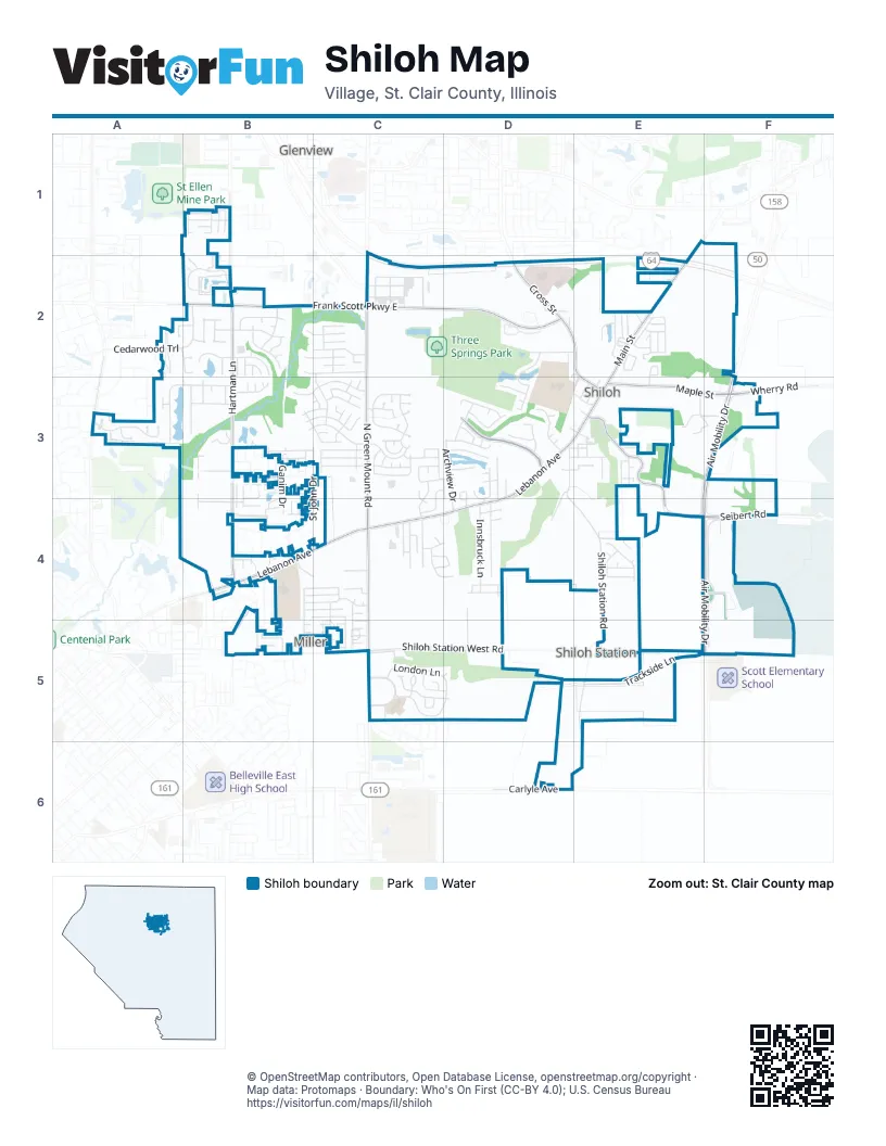
Street index of Shiloh
Each street on the sheet and the grid squares it crosses.
- Air Mobility DriveF3, E4, F4, E5, F5
- Carlyle AvenueD6
- Lebanon AvenueD3, B4, C4, D4
- North Green Mount RoadC2, C3, C4, C5
- Frank Scott Parkway EastB2, C2, D2
- Cross StreetD2, E2, E3
- North Main StreetE2, E3
- Maple StreetE3, F3
- South Main StreetD3, E3
- Thouvenot LaneB2
- Hartman LaneB1, B2, B3, B4
- Seibert RoadE3, E4, F4
- Grand Summit BoulevardD3
- Old Collinsville RoadA3
- Wherry RoadF3
- Green Mount Crossing DriveC2
- Shiloh Station West RoadC5, D5
- Shiloh Station RoadE4, E5, D6, E6
- London LaneC5, D5
- Wingate BoulevardC5
- Section Line RoadF4, F5
- East B Street RoadB5, C5
- West Waters Edge DriveA3, B3
- County Road 43D3, E4
- Trackside LaneE5
- Metro Plaza LaneF4
- Centerpoint CircleB2
- Lake Suzanne Mobile AcresE2
- Innsbruck LaneD4
- Messinger TrailA3
- St John DriveC3, C4
- Chippewa DriveC3
- Westinghouse DriveB3, C3
- Cedarwood TrailA2, B2
- St Andrews DriveD2, D3
- Cascade Lake DriveC2
- Linden DriveD4
- Archview DriveD3, D4
- Country Meadow LaneB3, B4
- Warrior WayB4
- Johnson RoadE4
- Hunters WayB4, C4
- Greystone Estates ParkwayB3, C3
- Cheyenne Wells DriveB3, C3
- Glen Mor DriveC3
- Shiloh Station East RoadE5
- Prairie View RoadB3
- Lake Lucerne DriveB2, C2
- Anderson LaneB4, B5
- Middlebury WayC3
- Welsch DriveC5, D5
- Bobbie DriveE3, F3
- Calista RidgeC3
- Winthrop DriveB4, B5
- Williamsburg DriveB4, B5
- Harbor WayC3, D3
- Richland Prairie BoulevardB3
- Eden Park BoulevardD3
- Ganim DriveB3, B4
- Preswyck DriveB2
- Bluff Ridge LaneB3, C3
- Golden Spring ParkwayC3
- Birmingham DriveB2
- Haverford DriveB2
- Langford CourtC3
- Pebble Brook LaneE4
- Edbroke DriveC3
- Cromwell LaneB2
- Lucia LaneE2
- Lowell CourtE2
- Manchester DriveB1
- Cedar Mill DriveB4, B5
- Fox Glenn DriveC4, C5
- Country View DriveB3, B4
- Sir Lawrence DriveC4
- Golfview CircleD3
- Care DriveD2
- Osprey CourtD3
- East Waters Edge DriveB3
- Thicket DriveD3
- Christine DriveC4
- Piper Hills DriveC3
- Boatmans PointD3
- Deer Springs TrailB2
- Tanglebrook DriveB4, C4
- Tamarack LaneD2, E2
- Oxen DriveB3
- Sequoia PlaceA2
- Woods Edge DriveC4, D4
- Coniferous DriveB3, C3
- Twin Oaks DriveD3, D4
- Eastridge DriveC4, C5
- Grand ReserveD3
- Meridian Lake DriveB2, C2
- Berwick CrossingC5
- Shiloh Hts DriveE2, E3
- Kingsley DriveB1
- Acorn Lake DriveD3, D4
- Chatham DriveB2
- High Valley LaneC2
- Pipers CourtC3
- Sandpiper DriveB3
- Sky Hawk DriveC3, D3, C4
- Crimson View DriveC3
- K and K LaneC5
- Simeon DriveC3
- Lauren Lake DriveB2, C2
- Eagles LandingC3, C4
- Willman LaneD4, D5
- Clairmont DriveB2
- Rachels WayB3
- Summit Estate CourtD3
- Willoughby CircleC4, D4
- Stonebridge DriveB4, C4
- Plankway DriveB3
- Caton Run CrossingC3
- Ambridge DriveC3
- Dakota DriveC3
- Barton DriveC3
- West Winters StreetF5
- Country RoadB4
- South 2nd StreetD3, E3
- Hampshire LaneB2
- Crosswinds DriveC4, C5
- Nicholas DriveE2
- Buena VistaD3, D4
- Cloverridge LaneB4, C4
- Mahogany LaneA2, B2
- Raven Oak DriveB3
- Ramona DriveC4
- Rolling Meadows DriveD4
- Indian RidgeD3, D4
- Millbrook DriveB4, C4
- White Chapel DriveB1
- Hawkridge RunC3
- Sierra DriveB4
- Stonewall LaneE4
- Sunset DriveB2
- Wildcat CrossingD2, D3
- Scheibel LaneF1
- Aquarius DriveE2
- Old O'Fallon RoadD2
- Fortune BoulevardC2
- Conestoga LaneE4
- Patrick DriveB4
- Navajo TrailC3
- Southridge DriveE3
- Fern Glen PreserveD3, E3, E4
- Hartfield LaneC4
- North DriveF4, F5
- Enlisted DriveF4
- Wellington DriveB3, B4
- Fairway DriveD3
- Green Ash CourtA2, B2
- Plainfield WayC3
- Timberline CourtD3, E3
- Antiquity LaneB5
- Breezy HillD3
- Phillips LaneC4, D4
- Rhetts LandingD3
- Warriors WayB4, C4
- Beauregard DriveC5
- Firefly DriveB2
- Sassafras DriveE4
- St George DriveB4
- Hideaway HollowE2
- Tailfeather DriveB3, B4
- Windsor Crest CourtB3, C3
- Knightsbridge CrossingC3
- Meadowbruck LaneD4
- Briarberry DriveD3
- Holyoke DriveB1
- Locust DriveE3
- Tribe CourtC4
- Brigton DriveC4
- Kinney DriveB3
- Waterford DriveB3
- South Old State Route 158F3
- Shiloh Ridge DriveB4
- Mayfair DriveC5
- Rockwood DriveB4
- Old School House CircleA3
- Katrine Lake DriveC2
- Clinton View CourtA3
- Red Fox RoadE3
- East Julie StreetE3
- DocklowB2
- Geneva Lake DriveC2
- Linwood LaneD4
- Stillwater Lake DriveC2
- Radcliff RoadB3, B4
- Tobias DriveE2
- Mallard Bend CourtB2
- MapleF3
- Sinn RoadE3
- Cornelius DriveE2
- Venus DriveE2
- Marcus DriveE2
- Biggs DriveB4
- Montrose CourtD3, D4
- Capril LaneC3
- Park DriveE3
- Three Springs TrailE3, F3
- Cindy LaneE3, F3
- Evertide DriveB2
- Magena CourtC3
- South High StreetE3
- Eagle DriveD3
- Pheasant Ridge CourtB2
- Oak StreetE3
- Wilson Creek DriveB4
- Quail Ridge CourtB2
- Raintree DriveB3
- Durham StreetB2
- ChristyB3
- GleesonB3
- Meadowview LaneB3, C3
- Glenfield DriveB3
- Sarpy RoadB4
- Calgary DriveB4
- South 1st StreetD3, E3
- Kiefer LaneE3
- Kathy DriveE3
- Yorkshire LaneB5
- Diamond CourtE3
- Adler CourtC3, C4
- Carleton LaneB2
- Church StreetE3
- Kay StreetE3
- Jarvis DriveE2
- Pine Valley DriveC5
- Bridge Water DriveC5
- Ellington DriveB3
- Greenfield DriveB4
- Redbud LaneE3
- Springbrook DriveC5
- Hagen Lake RoadB3
- Caballer DriveB4, B5
- Taurus DriveE2
- Heathrow LaneC5
- Chippendale DriveB5
- IronwoodB2
- Justus DriveE2
- Corporate Center DriveF4
- Fawn DriveD3
- Monarch Lake LaneC2, C3
- Madero DriveB4
- Vintage ForestC4, D4
- Stargaze DriveB2
- York Port DriveB4
- Greenfield CourtB4
- Harbor PointD3
- Maranda EstatesE4
- Willoughby DriveB1
- Armory RoadF4
- Bannon Ridge CourtC3
- Cambury CourtC3
- East StreetE3
- Rasp StreetE3
- Caballeros BoulevardB4
- Grassland CourtC3
- Dumbar CourtC3
- Dunberry DriveB1
- Baltes DriveB4
- Edmar CourtA3
- Rogue RiverC3
- Penny LaneD4
- Biscayne Estates DriveA3
- Peartree LaneE2
- Wood Ranch CircleA3
- Shabin DriveB3
- Westplank DriveB4
- Beacon Point CourtC3
- Pleasant View CourtB4
- Blue Spruce CourtB2
- Waldon LaneC5, D5
- Brookstone CourtC5
- Fox Ridge CourtB2
- Hereford DriveD4
- Cedarspring CourtC4
- Charterview CourtC3
- Sage DriveD3
- Ashford Ridge CourtC3
- Cedar Creek CourtC5
- Scepter CourtC5
- O'Fallon Twp Line RoadD2
- Oxen CourtB3
- Corliss CourtC3
- Vintage CourtC4
- Red Scarlet CiourtC3
- West Julie StreetD3, E3
- Fielding LaneC5
- Hilltop DriveE3
- Ashley Cove CourtC3
- Baybrook CourtB3
- Bainbridge CourtB3
- Vintage Forest DriveC4
- Westfield CourtB3
- Hill StreetE3
- Rockwood CourtB4
Places on the map
- 54th Street Grill and Bar
- 9Round
- AirForce Inns
- Amazon Locker - 1301
- Anderson Lake
- Applebee's
- Arby's
- Ashley HomeStore
- Bank of Shiloh
- Bethel Tabernacle Church
- Catholic Credit Union
- Circle K
- Corpus Christi Catholic Church
- Cracker Barrel
- Dierbergs
- Faith Family Church
- Field A
- Field B
- Golden Corral
- Holiday Inn Express
- Klucker Hall
- Lake Suzanne
- Memorial Hospital East
- Memorial Hospital East Shiloh Heliport
- Mount Calvary Cemetery
- Park Place Dental
- Rain Garden
- Saint Clare Catholic Church
- Shiloh Community Park
- Shiloh Dog Park
- Shiloh Police Department
- Shiloh Valley Cemetery
- Tamarack Golf Club
- Target
- The UPS Store
- Three Springs Park
- Three Springs Park Trail
- Towerview Baptist Church
- Walgreens
- Wingate Elementary School
Next to Shiloh
- Edison Place
- Glenview map
- Miller
- Shiloh Station
© OpenStreetMap contributors, Open Database License, openstreetmap.org/copyright · Map data: Protomaps · Boundary: Who's On First (CC-BY 4.0); U.S. Census Bureau















