

Illinois map
St. Clair County map
About 251,149 people live here (Census Bureau, 2024 estimate). The sheet's index lists 123 streets; North Main Street, South Main Street and Douglas Road cross the most grid squares. Things to do inside the boundary: Cahokia Mounds State Historic Site and Downstate Illinois.
Open the map (PDF, US Letter)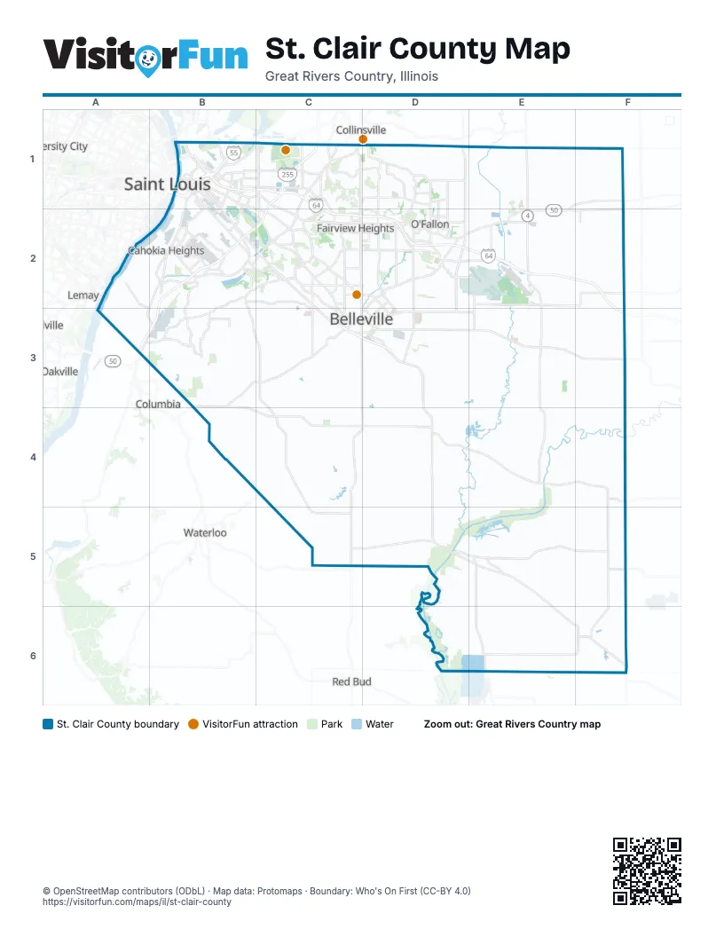
Street index of St. Clair County
Each street on the sheet and the grid squares it crosses.
- Argonne DriveB1
- Barack Obama AvenueB1
- Baugh AvenueB1
- Bunkum RoadB1, C1, C2
- Caseyville AvenueB1, C1
- Collinsville AvenueB1
- Collinsville RoadB1, C1
- Congressman William L. Clay Sr. BridgeB1
- Doctor Martin Luther King BridgeB1
- Eads BridgeB1
- East BroadwayB1
- Martin Luther King BridgeB1
- Martin Luther King DriveB1
- Mississippi AvenueB1, B2
- Missouri AvenueB1, B2
- N 2nd StreetB1
- North 10th StreetB1
- North 18th StreetB1
- North 25th StreetB1
- North 26th StreetB1
- North 38th StreetB1
- North 3rd StreetB1, E4
- North 8th StreetB1
- North 9th StreetB1
- Packers AvenueB1
- Pennsylvania AvenueB1
- Riverpark DriveB1
- S 2nd StreetB1
- Saint Clair AvenueB1, C1, C2
- South 4th StreetB1
- South 8th StreetB1
- South Main StreetB1, C1, D2, A3, B3, C4
- Stan Musial Veterans Memorial BridgeB1
- State StreetB1, C1, C2
- Caseyville RoadC1
- KingshighwayC1
- North 89th StreetC1
- North Illinois StreetC1, C2, C3
- North KingshighwayC1, C2
- North Main StreetC1, A2, B2, D2, A3, C4, C5, E6, F6
- South Bluff RoadC1
- South Morrison AvenueC1
- North Lincoln AvenueD1, D2
- O'Fallon Troy RoadD1
- Ofallon Troy RoadD1
- Scott Troy RoadD1, D2
- North Madison StreetE1, E2
- Old Highway 50E1, E2, F2
- Camp Jackson RoadB2
- diverging diamond interchangeB2
- Grand StreetB2
- Millstadt RoadB2, C3
- New Missouri AvenueB2, C2
- Old Missouri AvenueB2
- Old Saint Louis RoadB2, C2
- South 88th StreetB2, C2
- Stolle RoadB2
- Triple Lakes RoadB2
- Frank Scott ParkwayC2
- Frank Scott Parkway EastC2, D2
- Frank Scott Parkway WestC2
- Illinois Route 161C2
- Lebanon RoadC2
- Lincoln HighwayC2, D2
- Lincoln TrailC2
- North 88th StreetC2
- North 94th StreetC2
- North Belt EastC2, D2
- North Belt WestC2
- Old Lincoln TrailC2
- South Belt WestC2, C3
- South New Missouri AvenueC2
- West Main StreetC2, C3, E3
- Air Mobility DriveD2, D3
- Cross StreetD2
- Highway 50D2
- Lebanon AvenueD2, C3, D3
- Maple StreetD2
- North Green Mount RoadD2, D3
- Sherman StreetD2, D3
- South Lincoln AvenueD2
- Thouvenot LaneD2
- W State StreetD2
- West Highway 50D2
- West State StreetD2
- East Saint Louis StreetE2
- Scott DriveE2, E3
- South Madison StreetE2
- West McAllister StreetE2
- Old US Highway 50F2
- Summerfield South RoadF2
- West Hanover StreetF2
- Douglas RoadB3, B4, C4, D4
- South Illinois StreetB3, C3, D3, D4
- West Washington StreetB3, C3
- Centreville AvenueC3
- East A StreetC3, D3
- East Washington StreetC3, D3
- Floraville RoadC3, C4, C5
- Illinois StreetC3
- North Jefferson StreetC3, E3
- South 6th StreetC3
- South Belt EastC3, D3
- South Jefferson StreetC3, E3
- West A StreetC3
- Carlyle AvenueD3, E3
- East Main StreetD3, E3
- Forest AvenueD3
- Freeburg AvenueD3
- Mascoutah AvenueD3, E3
- North Oak StreetD3
- South Green Mount RoadD3
- Jefferson StreetE3
- County Highway 1848F3
- County Road 1848F3
- State Route 159C4, C5
- North State StreetD4
- South State StreetD4
- Urbanna DriveD4
- West Apple StreetD4
- Main AvenueE4
- Church StreetF4
- East Lyons StreetF6
Things to do on the St. Clair County map
Places on the map
- Aero Estates Airport
- Alorton
- Amazon SMO2
- Archview MX Park
- Beil Lake Number 2
- Belleville
- Belleville East High School
- Belleville West High School
- Beverly Ann Heights
- Bicentennial Park
- Bowman Pond
- Brookhill Estates
- Brooklyn
- Brushy Lake
- Cahokia
- Cahokia Khoury League
- Cahokia Marine
- Cahokia Mounds State Historic Site
- Cahokia Park
- Cardinal Creek Golf Course
- Cargo Ramp
- Caseyville
- Centenial Park
- Centerville Court Apartments
- Central City Apartments
- Centreville
- Centreville Park
- Citizen's Park
- Collinsville High School
- Columbia Golf Club
- Columbia Quarry
- Crown Pointe
- CSX Exermont Yard
- CSX Rose Lake Yard
- Dawson Manor
- Dupo
- Dupo Community Park
- Dupo Intermodal Terminal
- Dupo Quarterback Club
- East Carondelet
Next to St. Clair County
- Collinsville
- Columbia
- Lemay
- Oakville
- Red Bud
- Saint Louis
- University City
- Waterloo
© OpenStreetMap contributors (ODbL) · Map data: Protomaps · Boundary: Who's On First (CC-BY 4.0)