

Illinois map
Swansea map
About 14,445 people live here (Census Bureau, 2024 estimate). The sheet's index lists 300 streets; North Illinois Street, Frank Scott Parkway West and Old Collinsville Road cross the most grid squares. Things to do inside the boundary: Downstate Illinois.
Open the map (PDF, US Letter)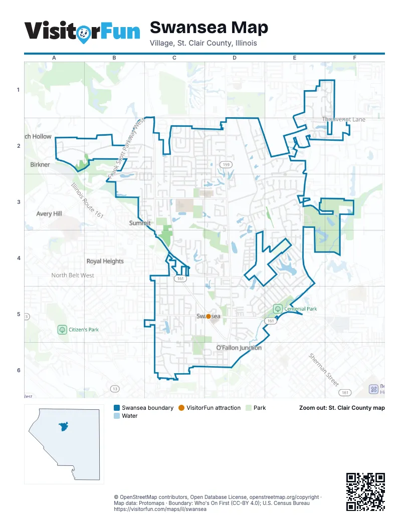
Street index of Swansea
Each street on the sheet and the grid squares it crosses.
- North Illinois StreetD2, D3, D4, D5, D6
- North Belt WestC4, C5, D5
- North Belt EastD5, E5
- Illinois Route 161C4
- Frank Scott Parkway WestC1, B2, C2, B3
- Frank Scott Parkway EastD1, D2, E2
- Thouvenot LaneE2, F2
- Old Collinsville RoadE1, E2, E3, E4
- Sullivan DriveC2, C3, C4
- North 17th StreetC4, C5, C6
- Huntwood RoadC3, D3
- Fullerton RoadC4, D4
- Boul AvenueC5, D5
- Morgan StreetC5, D5
- Union Hill RoadC2
- North 28th StreetC6
- Smelting Works RoadD2, D3, D4, D5
- Old Caseyville RoadC2, C3, C4
- Llewellyn RoadA2, B2, C2
- Caseyville AvenueC4, C5, C6, D6
- Lake Lorraine DriveE4
- Kinsella AvenueC5, C6
- Big Bend BoulevardC2, C3
- Gilbert StreetC6, D6
- Lyonshall BoulevardD3, E3
- Green Haven DriveC2, D2
- Munie RoadD3, E3
- Metro WayD5
- Merganser BoulevardE3
- Michael John DriveC2, C3
- RavenelE2, F2
- Rand LaneE3, E4
- Brackett StreetC6, D6
- Papillon DriveC2
- North 15th StreetC4, C5
- Old Park LaneB2, C2, B3, C3
- Saint Sabre DriveC2
- BivertonD2, E2
- Pinedale DriveC4, D4
- North 16th StreetC5
- Mary Jo DriveE4, D5, E5
- Duncan AvenueC5
- Roger StreetC5
- Anna StreetD5
- Pineywoods DriveC4, D4
- Hidden Lakes DriveE3, F3
- McDonald BoulevardD4
- Twin Lake DriveC3, D3
- Mimosa AvenueD2
- Bassen DriveB2, C2
- Wolf Creek DriveC3, D3
- Bobbie DriveD5, E5
- Goldenrod LaneC2
- Wood Duck DriveE3, E4
- Tanbark DriveD2, D3
- Barrett Lake DriveD3, E3
- Olroyd DriveE4
- Grimmig RoadD3
- Pasteur LaneD2, E2
- Carrington WayB2, B3
- Appaloosa DriveC2, C3
- Redfield DriveD2, E2
- Helen StreetD5
- Bristol Hill DriveF1, F2
- Old Fullerton RoadD4, D5
- Renoir AvenueE2
- Naughton WayB2, C2
- Leighigh DriveC3
- Britanna DriveD4, D5, E5
- Marilyn AvenueC5
- Turnbridge DriveE5
- Bourdelais DriveC2
- Ednick DriveD3
- Village DriveD2
- Deerfield DriveC3
- Chambers BoulevardD4
- North 2nd StreetD6
- Timber RidgeD5
- Lakeland BoulevardC2, D2
- Arly HillE1, F1
- Bridle LaneC4
- North 1st StreetD6
- Pensoneau DriveC6, D6
- Shade Tree CourtC3
- Kendra Ann DriveC2, C3
- Kingsbury DriveC6
- Timber DriveE5
- Woodridge DriveD4
- Cantwell LaneE1
- Stafford WayB3
- Ambrose Terrace DriveB2
- Adam DriveE4, E5
- Englewood DriveC5
- Brian DriveE4, E5
- Whistling CoveE4
- Shawn DriveC5, C6
- Creekside DriveE4, E5
- Scottsdale DriveC3
- Rosewood Village DriveD4
- Park PlaceD4
- Ramsfield DriveD2, E2
- Benchmark Centre DriveE1, E2
- Service StreetD5
- Homestead AvenueC2, D2
- Jardin CourtC2
- Honeysuckle LaneC3
- Jay AvenueC5
- Winchester Grove CourtE1, F1
- Glenwood DriveD4, D5
- Banbury PlaceE3
- Bettina DriveC2, D2
- Narrow Leaf LaneB3
- Westwick CourtC3
- Barrett DriveD3, D4
- Fawn MeadowsE4
- Pawnee DriveD6
- Marla Kay DriveD5, E5
- Melvin Price Memorial City Park DriveC5, C6
- Aberdeen PlaceE3
- Garden StreetD5
- Gentry LaneB2
- Gretstoke PlaceD3, E3
- Barbury WayB2
- Persimmon DriveD4
- Catawba AvenueC6
- Stevens StreetC5
- Meta DriveC5
- Parkway DriveD5
- Derbyshire DriveD5, E5
- William LaneE3
- Botanical DriveC2
- Leawood DriveC3, D3
- Baron DriveC2
- St Clair Lake DriveC5
- Steinberg Farm RoadE3
- Huntwood CourtC3
- Lotus DriveD2, D3
- West J StreetC6, D6
- Timberlake DriveD2
- Thrush LaneC2, D2
- Rodin AvenueE2
- Sarah LaneE3
- Crestwood DriveC2, D2
- Wesleyan DriveF1
- Essex BoulevardB2, B3
- Dalton DriveB2
- Corporate DriveD2
- MoselleE2, F2
- Western AvenueC6
- Westgate DriveC5, C6
- Kimberly Lake DriveE2
- West H StreetC6
- Winward Way DriveB3
- Beechmont CircleC3
- Lake Front DriveC5
- Biltmore TerraceC5
- Buckland CourtC3
- Canopy Crest CircleB3, C3
- Herby LaneE2
- Baxston CourtB2
- Owl CreekE1
- Woodland Park DriveD3
- Castle DriveD5, E5
- Victoria Square CourtF1
- Keswick CourtC4
- Viburnum DriveC2, D2
- Polo Run DriveC4
- Winward Way CourtB3, C3
- Alexa DriveD5
- KatrinaE2, F2
- Redcastle PlaceE3
- Switala LaneC4, C5
- Twilight DriveD3
- West Belle StreetC4
- Anna Rose DriveC5
- Philecia DriveD5
- Bronze Pointe BoulevardD2
- Whispering Walk WayB3, C3
- Moorgate CourtC3
- Schobert DriveC5
- Wild Cherry LaneC4
- Chambers RoadD4
- Miller LaneC5
- Aragon CourtE2
- WarwickD3
- Thistle LaneC2, D2
- Willow LaneC5, C6
- Abinger PlaceE3
- Shae Fries DriveC5
- Charleton PlaceE3
- East Caroline StreetD5
- Pleasant Valley DriveD4, D5
- Clara StreetD5
- Willow Lake DriveC5
- Windcliffe DriveC4
- JaredE4
- Arundel PlaceE3
- Venus DriveD3
- Castellano DriveD5
- Pin Oak LaneC5
- Manas DriveC5
- Natalie DriveD4
- Benington DriveC2
- Addison DriveD2, E2
- Whitfield DriveC2
- Heatherwood DriveC2
- Penrose DriveC6
- Mars DriveD3
- West Pointe DriveD2
- White Pines PointE4
- Alex DriveD4
- Hilda Ann DriveC5
- Ivo DriveC5
- Urban WayC2
- Morgan LaneD4
- Arbor DriveC2
- Executive Woods CourtD2
- Fieldcrest DriveC2
- Harvest LaneC2
- Clifton Way CourtE1, F1
- Barrett CourtD3
- Lake Lorraine CourtE4
- Eiffel BoulevardE2, E3
- Lake Del MarE2
- Lindenleaf LaneC2
- Jamestown RoadC5
- Lindenwood DriveC6
- Andrew DriveD4
- CoppertonD2
- Pascal PlaceE2
- Kenwood DriveC6
- Wolf Meadow DriveD3
- Iris DriveC6
- Heidi RoadD4
- Rocky DriveD5
- Cunningham DriveC3
- Cobblestone LaneE4
- Jupiter DriveD3
- Polo CourtC4
- Dale Crest ManorC5
- Fox Trotter DriveC2
- Biverton DriveD2
- J C DriveD4
- Joel DriveE4
- Bond AvenueC6
- Pine StreetC5
- Cassatt CourtE2
- Round Hill RoadD3
- Bills DriveD5
- Wisteria CourtC4
- Comer AvenueC5
- Marlo WayC5
- Finch LaneB2, B3
- Redbird LaneC2, C3
- Fournie LaneD5
- Lake DriveC5
- Chesterfield CourtE3, E4
- Clinton Hill DriveE4
- Caleb CourtE3
- Lombardi CourtB3, C3
- Roclare DriveC5
- Kimberly Lake LaneE2
- Travis DriveD4
- Aspen PlaceD4
- Barrett CrossingD3
- Shelfield CourtD2
- Ambeer Meadows CourtD3
- Emerald TerraceD4
- Beau Gon DriveD2
- Johanna PlaceC5
- Purple BlossomC4
- Betz RoadD4
- Carthy DriveD4
- Kings CourtC5
- Melinda CourtD5
- Piney CourtD3
- Castle Pines CourtD3, E3
- North Illinois LaneD2
- Marcella DriveD5
- Edgelake CourtE4
- Timber Waters CourtE4
- Alhambra CourtC6
- Lashley Estates DriveE4
- Navy DriveD4
- Allen DriveC5
- Penny Rose DriveC6
- Brougham PlaceE3
- Calais CourtC2
- Sonoma WayD3
- St James DriveC5
- Short StreetC6
- Gundlach PlaceD6
- South DriveD6
- Gebhardt Lake RoadD4
- Castle CourtD5
- Goldeneye CourtE3
- Gaslight TerraceD4
- Josephine DriveD5
- Mercury DriveD3
- Benchmark CourtE1
Things to do on the Swansea map
Places on the map
- ALDI
- Applebee's
- Badgley Cemetery
- Bank of Edwardsville
- Bike Trail Map
- Boul Avenue Trail
- Burger King
- Cambridge House of Swansea
- Centenial Park
- Centenial Park Trail Map
- Cholula's Mexican Restaurant
- CVS Pharmacy
- Dobb's Tire & Auto
- Dollar Tree
- Don's Hardware
- FCB Bank
- Gepperts Lake
- High Mount School
- Hokkaido
- Holy Shoghagat Armenian Church
- Hucks
- Knights of Columbus Council
- MedExpress Urgent Care
- Melvin Price Memorial City Park
- PAK MAIL
- Rural King
- Saint Constantine and Saint Helen Church
- Schnucks
- Schranz Memorial Park
- St Clair Lake
- Swansea Clinton Hills Conservation Park
- Swansea Volunteer Fire Department
- The Village of Swansea Government Center
- Walgreens
- Westview Baptist Church
- Winchester Plaza
- Wolf Branch Middle School
- Wolf Branch St. Clair Township Park
- Yoch Lake
Next to Swansea
- Avery Hill
- Birkner
- Dutch Hollow
- Royal Heights
- Summit
© OpenStreetMap contributors, Open Database License, openstreetmap.org/copyright · Map data: Protomaps · Boundary: Who's On First (CC-BY 4.0); U.S. Census Bureau















