

Illinois map
Wayne map
About 64,190 people live here (Census Bureau, 2024 estimate). The sheet's index lists 99 streets; Army Trail Road, Dunham Road and Surrey Road cross the most grid squares. Also on it: Dunham Forest Preserve, Wayne Elementary School and White Gates Skeet Club.
Open the map (PDF, US Letter)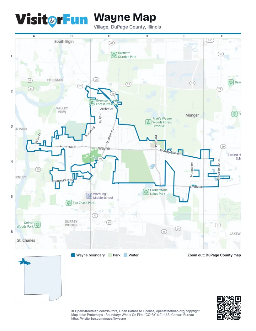
Street index of Wayne
Each street on the sheet and the grid squares it crosses.
- Stearns RoadB2
- Ashley LaneC2, C3
- Brewster Creek CircleC2
- Dunham RoadC2, C3, C4
- Lamplight TrailC2
- Pearson DriveA3, A4
- Weber DriveA3, A4
- Deerwood FarmB3, B4
- Historic Country RoadB3, B4
- Mare Barn LaneB3, C3
- Roberts RoadB3
- Sulky RoadB3, C3
- Surrey RoadB3, C3, B4
- Behles WayC3
- Chambellan LaneC3, C4
- Courcival LaneC3, D3
- Dunham CircleC3
- Dunham CourtC3
- Dunham Trail RoadC3, C4
- Hub RoadC3
- Oak Lawn Farm RoadC3, D3, C4
- Rochefort LaneC3, D3
- Serinne LaneC3
- Shagbark LaneC3
- Thorncroft DriveC3
- Woodland DriveC3
- WoodmereC3
- Woodmere LaneC3
- Billy Burns RoadD3, D4
- Derby RoadD3, D4
- Guild LaneD3, D4
- Powis RoadD3, D4, D5
- Pratt RoadD3, D4
- Army Trail RoadA4, B4, C4, E4, F4
- Pinelands RoadA4
- Country Club RoadB4, A5, B5
- Curling Pond RoadB4, C4
- Fletcher RoadB4, C4
- Fox Glen DriveB4
- Nelson DriveB4, B5
- Robin LaneB4
- Sawmill TrailB4, B5
- White Thorn RoadB4, C4
- Haw RoadC4
- Honey Hill CircleC4, C5
- Honey Hill Circle NorthC4, D4
- Honey Hill DriveC4
- Honey Hill RoadC4
- North Honey Hill CircleC4
- Royal Fox DriveC4
- West Army Trail RoadC4, D4, E4
- Anthony CourtD4, D5
- Cedar LaneD4
- Churchill LaneD4
- Elm RoadD4
- Glos StreetD4
- Keil StreetD4
- Nancy LaneD4
- Orchard LaneD4
- Percheron LaneD4
- Peterson DriveD4
- Pratt Woods CourtD4
- Railroad AvenueD4
- Russell RoadD4
- School StreetD4
- Will WayD4
- Bradford ParkwayE4
- Grove PlaceE4
- Munger RoadE4, E5
- Ridge LaneE4
- Rue Prè de MunoE4
- Wiltshire CourtE4, E5
- Dean CourtF4
- Heritage CourtF4
- Illinois Route 59F4, F5
- Kaelin RoadF4
- Lysle RoadF4
- Magnolia LaneF4, F5
- Maple Tree LaneF4
- Mountain Ash DriveF4, F5
- White Oak LaneF4
- Aintree RoadB5
- Honey Hill Circle SouthC5, D5
- South Honey Hill CircleC5
- Nicholas DriveD5
- Berkshire CourtE5
- Kingswood CourtE5
- Lake Eleanor CourtE5
- Lake Eleanor DriveE5
- Prairie LaneE5
- Smith RoadE5, F5
- Somerset CourtE5
- Warwick WayE5
- Woodland CourtE5
- Woodland Trail SouthE5
- Woodland Trail WestE5
- Forsythia LaneF5
- Honeysuckle LaneF5
- Lakewood CourtF5
Places on the map
- Dunham Castle
- Dunham Forest Preserve
- Next Level HiFi
- Wayne Congregational Church
- Wayne Elementary School
- White Gates Skeet Club
Next to Wayne
- Coleman
- Farmington
- Five Island Park
- Fox River Estates
- Fox River Heights
- Lakewood
- Munger
- Novak Park
- South Elgin map
- St. Charles map
- Surrey Woods
- Thornley
- Valley View
© OpenStreetMap contributors, Open Database License, openstreetmap.org/copyright · Map data: Protomaps · Boundary: Who's On First (CC-BY 4.0); U.S. Census Bureau















