

Illinois map
South Elgin map
About 24,921 people live here (Census Bureau, 2024 estimate). The sheet's index lists 300 streets; McLean Boulevard, West Thornwood Drive and Randall Road cross the most grid squares. Things to do inside the boundary: Fox River Trolley Museum.
Open the map (PDF, US Letter)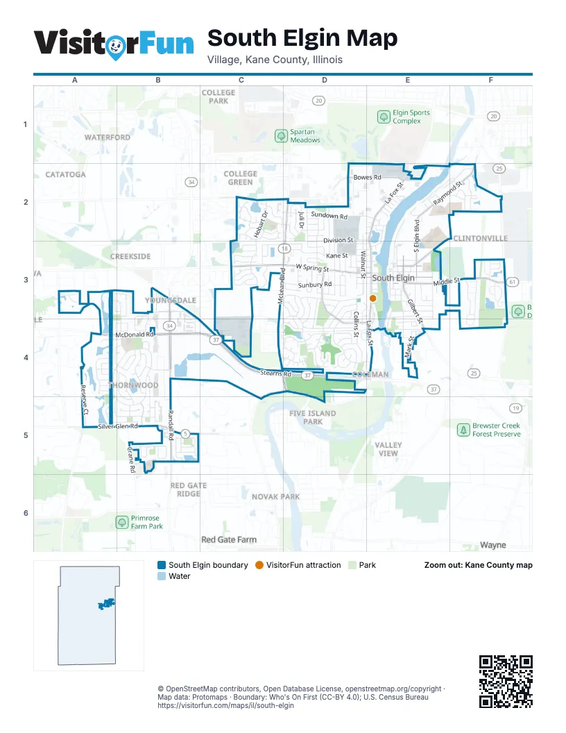
Street index of South Elgin
Each street on the sheet and the grid squares it crosses.
- Randall RoadB3, B4, B5
- North La Fox StreetE2, E3
- South La Fox StreetE3, E4
- Stearns RoadB4, C4, D4
- McLean BoulevardD2, D3, C4, D4
- West Spring StreetC3, D3, E3
- Silver Glen RoadA5, B5
- Bowes RoadC2, D2, E2
- McDonald RoadA4, B4
- South Gilbert StreetE3, E4
- East Middle StreetE3, F3
- East State StreetE3
- Middle StreetF3
- West State StreetD3, E3
- State Street BridgeE3
- Concord AvenueD3, D4, E4
- Raymond StreetE2, F2
- North South Elgin BoulevardE2, E3
- East Main StreetE2, E3
- North Gilbert StreetE3
- Spruce StreetE3
- Burr RoadA5
- Sundown RoadC2, D2, E2
- Kane StreetD3, E3
- East Thornwood DriveB4, B5
- South Collins StreetD3, D4
- Hancock AvenueD3, D4, E4
- Gyorr AvenueB3, B4
- West Thornwood DriveA4, B4, A5, B5
- Hobart DriveC2, C3
- Sunbury RoadD3
- Martin DriveD2, D3
- Thornwood WayA3, B3, B4
- Valley Forge AvenueD3, D4
- Division StreetD2, E2, D3
- River RoadE2, F2
- Cole DriveA4, B4
- Briargate DriveB3, B4
- Medford DriveD3
- Brookwood DriveA5, B5
- South Lancaster CircleC4, D4
- Renee DriveD2, D3
- Reserve CourtA4, A5
- Franklin AvenueD4
- Chasewood DriveB4, B5
- Lake Ridge DriveB4
- Sutton DriveA5, B5
- Dean StreetD2, D3
- Schneider DriveD2
- Waters Edge DriveA4
- Burke LaneC2
- Thornwood BoulevardB5
- Michigan AvenueD2, D3
- Fulton StreetE3, E4
- Mill StreetE3
- Riverview AvenueE2, F2
- Redington DriveB4, B5
- Waterside DriveA4, B4, B5
- Sandhurst LaneC3, D3
- South East AvenueE3, E4
- North Camden LaneD4
- North Walnut StreetD2, D3
- South Pointe AvenueF3
- North Lancaster CircleD3, D4
- Jenna DriveC2, D2
- Robertson RoadE2, E3
- Barry RoadF3
- Glenwood DriveB5
- Nicole DriveA3, B3
- Sagebrook DriveB5
- Kateland WayB4, B5
- Shanahan DriveC4
- Ridge RoadC2
- Juli DriveD2
- Hamilton DriveB5
- Mark StreetE4
- Woodbury StreetE3
- North Collins StreetD3
- North Lancaster RoadC3
- Thornwood AvenueB4
- Windsor CourtD3, E3, D4
- Angeline DriveC2
- Harwood AvenueB5
- Carriage WayB4
- Paine StreetD3, D4
- Sunrise DriveB5
- Fieldcrest DriveC2
- Dublin LaneD3, D4
- Kingsport DriveC3
- Crane RoadB5
- South Pembroke DriveC3
- Woodland DriveC3
- Ione DriveC3
- Deer Pointe DriveF2
- East Lynn StreetD3
- Arlington LaneD4
- Pleasant DriveE3
- West Camden LaneD4
- Asbury BoulevardB5
- Courtland DriveA3, B3
- Fairview LaneC2
- Hickory LaneE3, E4
- Manchester CourtD3
- Prairie Point DriveF2
- East Spring AvenueE3
- Quarry StreetD3, E3
- Lexington AvenueD3
- Persimmon LaneA4
- Wedgewood DriveD3
- North Pembroke DriveC3
- Ann StreetE3
- Cornwall AvenueD3, D4
- North Water StreetE2, E3
- East Harvard CircleD3, D4
- Prairie StreetD3, E3
- Saratoga CourtD3
- Sweetbriar CourtD3
- West Harvard CircleD3
- Fenwick LaneD2
- Mayfair LaneD3
- Greenfield AvenueD2
- Joseph DriveC3, C4
- Moraine DriveF3
- Robin Glen LaneB3, B4
- Sterling LaneA4
- Fairfax LaneD4
- Beck AvenueE2
- East Ellington CourtB4
- West Middle StreetD3, E3
- Ashton LaneA4
- Crystal AvenueE3
- Oak LaneA4, B4
- South River StreetE3
- Woodridge CircleD4, E4
- Parkwood CircleB4
- Riverside DriveE3, E4
- Exeter LaneC3
- Lucille StreetE3
- Stevenson RoadD2
- Richmond CircleF2
- Arbor LaneD4
- North DriveE4
- Oak StreetE3
- Terrace LaneB4
- Farmer CircleF3
- South Blackhawk CircleC3
- West Ellington CourtA4, B4
- Heartland LaneB5
- Oxford LaneD3
- Trenton AvenueD3
- Wyndham DriveE2, F2
- Bunker Hill AvenueD3
- Lansbrook DriveA4
- Stone StreetD3, E3
- Park AvenueE4
- Cambridge RoadD3
- Josephine AvenueE2
- Sterling Woods LaneA3
- Ashton CourtD4
- Elizabeth StreetE3
- North Center StreetE3
- Pamela DriveB5
- Waterford LaneD4
- Marleigh LaneC2
- Chesterfield LaneD4
- Oakwood LaneD4
- South Walnut StreetD3
- Birch LaneC3
- Barbara AvenueD3
- Lafayette DriveD3
- East Plum StreetE3
- Lowell DriveC3
- Carla DriveD3
- Gerald AvenueD2
- Gilpen AvenueE2
- North Harvard CircleD3
- Independence AvenueD3
- Locust StreetE3
- North Haverhill LaneD4
- Williams DriveE4
- Hilltop LaneE4
- Melinda DriveD3
- Umbdenstock RoadC3, C4
- Industrial DriveD2, E2
- Helen AvenueD3
- South Haverhill LaneD4
- South StreetE3
- Production DriveD2, E2
- Foxborough RoadB5
- Forest TrailB3, B4
- Kossuth StreetD3, E3
- Lor Ann StreetE3
- Juniper LaneD3, D4
- Brookside DriveA4
- Timber LaneC3
- Liberty AvenueD3
- Melrose AvenueE2
- Rochester LaneB5
- West Sandstone CourtB5
- Countryside LaneA4
- Kenilworth AvenueD2
- North Blackhawk CircleC3
- Denton LaneB3, B4
- Holt LaneB3
- North Thorndale LaneD4
- East Sandstone CourtB5
- Brookwood CourtB5
- East Thorndale LaneD4
- Cherry StreetE3
- Brookline StreetD3
- Virginia DriveD3
- West Lynn StreetD3
- South Water StreetE3
- Adrienne DriveD2
- Oakview CourtA3
- Hannah CourtA3
- South Center StreetE3
- Eastview AvenueE3
- Lily Pond LaneB4
- North Main StreetE3
- Legacy DriveB5
- Beach CourtE2
- Rainbow TerraceD2
- James StreetD2
- Ascot LaneA4, B4
- South London CourtD3, C4, D4
- Woodrow AvenueE2
- Blazing Star StreetF3
- Mavis AvenueE2
- Scott AvenueD4
- Aaron AvenueD3
- Ashbrook LaneD4
- Nolen DriveC4
- Wilson WayE2
- Shady LaneA3
- Stonington PlaceD3
- Patrick DriveE3
- Charles CourtD3
- Louise DriveC4
- Ross AvenueE2
- Boston CourtD3
- Sheffield CourtC2
- North Conway CourtE4
- Sunflower StreetF3
- Sweetflag StreetF3
- Ashford LaneA5
- Champagne LaneC2
- Longbow CourtD4
- Arthur AvenueE2
- Commerce DriveE2
- Melrose CourtE2
- Ridge CourtC2
- Brittany CourtD2
- Cedar CourtC4, D4
- Chipstone DriveE2
- Crestwood DriveB4
- South Conway CourtD4, E4
- Juli CourtD2
- West Plum StreetE3
- North London CourtC3, D3
- Spring StreetE3
- Roxbury CourtD2
- Carter CourtA4, B4
- Hollywood CourtE2
- Linda CourtE4
- South Lakewood CourtD4
- Mestic CourtE2
- Revere RoadD3
- Wills StreetD3
- Stratford CourtD4
- Warwick CourtD4
- South South Elgin BoulevardE3
- Clove CourtD4
- Hartman CourtE2
- Hobart CourtC2
- Moody CourtF2
- Carlton CourtF2
- Kingsport CourtC3
- South Main StreetE3
- Farmington CourtC2
- Soldiers RoadE2
- Weston CourtC3
- East Parkview DriveB5
- Lincoln CourtD4
- Marbury CourtD3
- Longview CourtD4
- West Parkview DriveB5
- Jenna CourtC2
- Quarry CourtD2, E2
- Berkshire CourtD4
- Frederick CourtC2
- North East AvenueE3
- South DriveE4
- Sunbrook StreetD3
- Thorndale CourtD4
- Barcroft CourtC2
- Earl LaneE4
- Gordon LaneE3
- Lake Ridge CourtB4
- Village CourtD4
Things to do on the South Elgin map
Places on the map
- Angelo Caputo's Fresh Markets
- AutoZone
- Best Buy
- Blackhawk Park
- Brookside Park
- Buffalo Wild Wings
- Burger King
- Chase
- Cleveland Veterinary Clinic
- Clinton Elementary School
- Corron Elementary
- Corron Park
- County Park
- Culver's
- CVS Pharmacy
- Exxon
- First American Bank
- Fox Meadow Elementary School
- Fox Meadow Park
- Fox River Quarry
- Fox River Trolley Museum
- Frank's Freshway Market
- Fruitful Yield Natural Market
- Gail Borden Public Library - South Elgin Branch
- goodstop by Casey's
- Jim Hansen Park
- Kenyon Woods Middle School
- Lions Park
- Northwestern Medicine
- Panton Mill Park
- Pickeral Point Park
- Ralph E Tredup Park East
- Robert Sperry Park
- South Elgin High School
- South Elgin Post Office
- St Patrick Catholic School
- Thornwood
- Thornwood Retention Path
- Turner Seaplane Base
Next to South Elgin
- Catatoga
- Clintonville
- Coleman
- College Green
- College Park
- Creekside
- Edgewater
- Farmstead
- Ferson Creek Woods
- Five Island Park
- Fox River Estates
- Fox River Heights
- Heatherfield
- Longview Estates
- Mulberry Grove
- Niskayuna
- Novak Park
- Otter Creek
- Red Gate Farm
- Red Gate Ridge
- Reserve Of Saint Charles
- River Grange Lakes
- Seasons At Elgin
- Seven Oaks Farm
- Sidney E Read's Subdivision
- Silver Glen Estates
- The Reserve
- Three Lakes
- Valley View
- Waterford
- Wayne map
- West-Scott Estates
- Woodbridge South
- Woodridge North
© OpenStreetMap contributors, Open Database License, openstreetmap.org/copyright · Map data: Protomaps · Boundary: Who's On First (CC-BY 4.0); U.S. Census Bureau















