

Indiana map
Allen County map
About 399,295 people live here (Census Bureau, 2024 estimate). The sheet's index lists 194 streets; Ronald Reagan Expressway, Lima Road and Leo Road cross the most grid squares. Things to do inside the boundary: Fort Wayne Zoo.
Open the map (PDF, US Letter)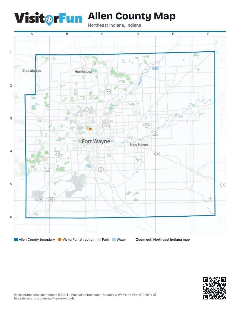
Maps inside Allen County
1 map inside, from the street map of Allen County down.
Street index of Allen County
Each street on the sheet and the grid squares it crosses.
- Lima RoadB1, B2, C2, C3
- Old State Road 3B1
- West Cedar Canyons RoadB1, C1
- West Shoaff RoadB1, C1, B2
- Auburn RoadC1, C2, C3
- Coldwater RoadC1, C2, C3
- County Road 11AC1
- County Road 327C1
- County Road 427C1
- East Cedar Canyons RoadC1
- East Shoaff RoadC1
- Tonkel RoadC1, C2
- Vandolah RoadC1
- Leo RoadD1, E1, C2, D2
- Hall RoadF1, F2
- Carroll RoadA2, B2, C2
- Bethel RoadB2
- Dupont RoadB2, C2
- Echowood LaneB2
- Fritz RoadB2, B3
- Hand RoadB2
- Hathaway RoadB2, C2
- Huguenard RoadB2, B3
- Johnson RoadB2, B3
- West Dupont RoadB2
- West Gump RoadB2, C2
- West Till RoadB2, C2
- Auburn Road ConnectorC2
- Corbin RoadC2
- Diebold RoadC2
- E Gump RoadC2
- East Dupont RoadC2
- East Gump RoadC2
- East Till RoadC2
- East Wallen RoadC2, C3
- Hosler RoadC2, D2
- Mayhew RoadC2, D3
- North Clinton StreetC2, C3, C4
- Ronald Reagan ExpresswayC2, C3, D3, D4, A5, B5, C5, D5, B6, C6
- Union Chapel RoadC2, D2
- Center StreetD2
- Flutter RoadD2, D3
- Grabill RoadD2
- Main StreetD2, F3, F4, F5
- Notestine RoadD2, E2, F2
- Old Union Chapel RoadD2
- Saint Joe RoadD2, C3, D3
- Saint Joseph StreetD2
- Schwartz RoadD2, D3
- State StreetD2, E2
- Wheelock RoadD2, D3
- Fahlsing RoadF2, F3
- Felger RoadA3
- Leesburg RoadA3, B3, B4
- South 800 East; West County Line Road NorthA3
- West Washington Center RoadA3, B3, C3
- Goshen RoadB3, C3
- Hillegas RoadB3, B4
- West Coliseum BoulevardB3, C3
- West Cook RoadB3, C3
- West Ludwig RoadB3, C3
- West State BoulevardB3, C3
- West Wallen RoadB3, C3
- Crescent AvenueC3
- East Coliseum BoulevardC3
- East Cook RoadC3
- East Fernhill AveC3
- East Ludwig RoadC3
- East State BoulevardC3, D3
- East Washington Center RoadC3
- Edgewood AvenueC3
- Executive BoulevardC3
- Fernhill AvenueC3
- Goshen AvenueC3
- Hobson RoadC3
- Ley RoadC3
- North Anthony BoulevardC3, C4
- North Coliseum BoulevardC3, C4
- North Wells StreetC3, C4
- Oakbrook ParkwayC3
- Parnell AvenueC3
- Progress RoadC3
- Reed RoadC3, C4
- Rothman RoadC3, D3
- Saint Joe Center RoadC3, D3
- Saint Joe River DriveC3
- Sherman BoulevardC3, C4
- Speedway DriveC3
- Spy Run AvenueC3, C4
- St Joe Center RoadC3
- St Joe RoadC3
- State BoulevardC3
- Stellhorn RoadC3, D3, E3
- West Fernhill AveC3
- Landin RoadD3, D4
- Maplecrest RoadD3, D4
- Maysville CircleD3
- Maysville RoadD3, D4
- North Webster RoadE3
- Old US 24E3, F3
- Platter RoadE3
- Rohman RoadE3
- Thimlar RoadE3
- Webster RoadE3
- County Rd 424F3
- County Road 424F3
- Hetrick RoadF3, F4, F5
- Aboite Center RoadA4, B4
- Bass RoadA4, B4
- Covington RoadA4, B4, C4
- Homestead RoadA4, A5
- Illinois RoadA4, B4
- Liberty Mills RoadA4, B4
- North Scott RoadA4
- South 800 East; West County Line Road SouthA4, A5
- South Scott RoadA4
- West Hamilton Road NorthA4
- West Hamilton Road SouthA4
- Apple Glen BoulevardB4
- Ardmore AvenueB4, B5
- Engle RoadB4
- North Hadley RoadB4
- North Thomas RoadB4
- South Hadley RoadB4
- South Illinois RoadB4
- South Thomas RoadB4
- Spring StreetB4, C4
- Taylor StreetB4, C4
- West Jefferson BoulevardB4, C4, A5, B5
- Airport ExpresswayC4, B5, C5
- Bluffton RoadC4, C5, C6
- BroadwayC4
- Brooklyn AvenueC4
- Clay StreetC4
- Clinton StreetC4
- Columbia AvenueC4
- Delta BoulevardC4
- East Jefferson BoulevardC4
- East Main StreetC4
- East Paulding RoadC4, D4
- East Pontiac StreetC4
- East Washington BoulevardC4
- Fairfield AvenueC4, C5
- Hessen Cassel RoadC4, C5
- Lafayette StreetC4, C5
- Lake AvenueC4, D4
- Maumee AvenueC4
- N Clinton StreetC4
- Old Mill RoadC4
- Pioneer StreetC4
- Saint Joseph BoulevardC4
- South Anthony BoulevardC4, C5
- South Clinton StreetC4
- South Coliseum BoulevardC4
- Superior CircleC4
- Van Buren StreetC4
- Wayne TraceC4
- Wells StreetC4
- West Main StreetC4
- West Paulding RoadC4
- West Pettit AvenueC4
- West Washington BoulevardC4
- Adams Center RoadD4, D5
- Broadway StreetD4
- Dawkins RoadD4, E4, F4
- Green StreetD4
- Hartzell RoadD4, D5
- Lincoln Highway EastD4
- Lincoln Highway WestD4
- Maplecrest Road;South Maplecrest RoadD4
- Minnich RoadD4, D5, D6
- Moeller RoadD4
- Powers StreetD4
- Rose AvenueD4
- Seiler RoadD4
- South Maplecrest RoadD4
- West Moeller RoadD4
- West State Road 930D4
- Railroad StreetF4
- Fogwell ParkwayA5
- Lafayette Center RoadA5
- Lower Huntington RoadA5, B5, C5
- North 600 East; West County Line Road SouthA5
- Indianapolis RoadB5, A6, B6
- Smith RoadB5
- West Ferguson RoadB5, C5
- Decatur RoadC5, D6
- East Tillman RoadC5, D5
- West Tillman RoadC5
- Marion Center RoadD5
- East South StreetF5, F6
- Lincoln HighwayF5
- North Marzane RoadA6
- North 400 EF6
Things to do on the Allen County map
Places on the map
- Aboite Lake Estates
- Airport North Office Park
- Aldale Acres
- Allen County
- Allen County Fairgrounds
- Alumni Park
- Amazon Cross-Dock FWA4
- Amazon Distribution Center
- Apple Glen
- Archers Pointe Apartments
- Arcola
- Ardmore Quarry
- Arlington Heights
- Arlington Park
- Arlington Park Golf Course
- Arrowhead Marsh
- Ashford Lakes
- Aslan Passage
- Atrium Village
- Auburn Farms
- Autumn Ridge Golf
- Avalon at Northbrook
- Azbury
- Balmoral
- Becketts Run
- Beedy Lake
- Bellair
- Beverly Heights
- Bicentennial Woods
- Blackhawk
- Blackhawk Apartments
- Blair
- Blue Cast Springs Preserve
- Bob Arnold Northside Park
- Bohde Grove
- Bonterra Apartments
- Brandonwood
- Brandy Chase
- Branning Hills
Next to Allen County
- Churubusco
© OpenStreetMap contributors (ODbL) · Map data: Protomaps · Boundary: Who's On First (CC-BY 4.0)