

Indiana road map
I-69 in Indiana map
I-69 is about 315 miles in Indiana, in 2 separate stretches. It has 91 exits, from Exit 0 at mile 1 to Exit 357 at mile 314. It meets 63 highways; IN 37, IN 3 and IN 1 meet it in the most grid squares.
Open the map (PDF, US Letter)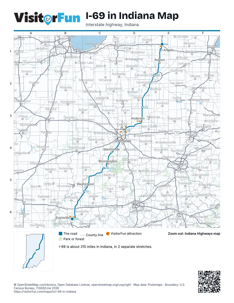
Exits on I-69 in Indiana
Each exit in mile order, with its grid square.
- Exit 0mile 1, B6
- Exit 3mile 4, B6
- Exit 7Amile 7, B6
- Exit 7Bmile 7, B6
- Exit 9mile 9, B6
- Exit 10mile 10, B6
- Exit 15mile 16, B6
- Exit 18mile 18, B6
- Exit 19mile 19, B6
- Exit 21Amile 21, B6
- Exit 29Bmile 21, B6
- Exit 29Amile 21, B6
- Exit 21Bmile 21, B6
- Exit 22mile 22, B6
- Exit 27mile 27, B6
- Exit 33mile 33, B6
- Exit 46mile 46, B5
- Exit 62mile 61, C5
- Exit 76mile 74, C5
- Exit 87mile 86, C5
- Exit 98mile 96, C5
- Exit 104mile 102, C5
- Exit 114mile 112, C5
- Exit 115mile 113, C5
- Exit 116mile 113, C5
- Exit 117mile 115, C5
- Exit 118mile 116, C5
- Exit 120Amile 117, C4
- Exit 120Bmile 117, C4
- Exit 120 Amile 118, C4
- Exit 120 Bmile 118, C4
- Exit 123mile 121, C4
- Exit 125mile 123, C4
- Exit 134mile 132, C4
- Exit 137mile 134, C4
- Exit 138mile 135, C4
- Exit 140mile 138, C4
- Exit 145mile 142, C4
- Exit 153mile 150, D4
- Exit 156mile 153, D4
- Exit 158mile 155, D4
- Exit 160mile 157, D4
- Exit 162mile 158, D4
- Exit 163mile 159, D3
- Exit 37Bmile 159, D3
- Exit 200mile 159, D3
- Exit 201mile 160, D3
- Exit 203mile 162, D3
- Exit 204mile 163, D3
- Exit 205mile 163, D3
- Exit 210mile 169, D3
- Exit 214mile 173, D3
- Exit 219mile 177, D3
- Exit 222mile 181, D3
- Exit 226mile 185, D3
- Exit 234mile 191, D3
- Exit 241mile 198, D3
- Exit 245mile 203, D3
- Exit 255mile 213, D3
- Exit 259mile 217, D3
- Exit 264mile 222, D3
- Exit 273mile 231, D2
- Exit 278mile 236, D2
- Exit 286mile 244, D2
- Exit 296Amile 254, D2
- Exit 0Amile 254, D2
- Exit 296Bmile 254, D2
- Exit 299mile 256, E2
- Exit 302mile 260, E2
- Exit 305mile 263, E2
- Exit 309Amile 266, E2
- Exit 309Bmile 267, E2
- Exit 311Amile 268, E2
- Exit 311Bmile 268, E2
- Exit 312Amile 269, E2
- Exit 312Bmile 270, E2
- Exit 312mile 270, E2
- Exit 315mile 272, E2
- Exit 31B–Cmile 272, E2
- Exit 316mile 273, E2
- Exit 317mile 274, E2
- Exit 326mile 283, E1
- Exit 329mile 286, E1
- Exit 334mile 291, E1
- Exit 340mile 298, E1
- Exit 348mile 305, E1
- Exit 350mile 308, E1
- Exit 354mile 311, E1
- Exit 356mile 312, E1
- Exit 144mile 313, E1
- Exit 357mile 314, E1
Highways I-69 meets
Each highway it meets and the grid squares where they meet.
- US 41B6
- IN 66B6
- IN 62B6
- IN 57B6
- I-64B6
- IN 68B6
- IN 168B6
- IN 64B6
- IN 61B5
- IN 56B5
- IN 356C5
- IN 257C5
- US 50C5
- US 150C5
- IN 550C5
- IN 58C5
- US 231C5
- IN 45C5
- IN 54C5
- IN 445C5
- IN 37C5, D3
- IN 48C5
- IN 46C4
- IN 39C4
- IN 252C4
- IN 44C4
- IN 144D4
- IN 13D3
- IN 38D3
- IN 132D3
- IN 9D3
- IN 67D3
- IN 109D3
- IN 236D3
- IN 32D3
- IN 28D3
- IN 332D3
- US 35D3
- IN 26D3
- IN 22D3
- IN 18D3
- IN 5D2
- IN 218D2
- IN 124D2
- US 224D2
- IN 3D2, E2
- I-469D2
- US 33D2
- US 24D2
- IN 1D2, E2
- IN 14E2
- US 30E2
- IN 930E2
- US 27E1, E2
- IN 8E1
- US 6E1
- IN 4E1
- US 20E1
- IN 127E1
- IN 727E1
- IN 120E1
- I-80E1
- I-90E1
Towns along I-69 in Indiana
In mile order, with the grid square of each.
- Evansvillemile 0, B6
- Elberfeldmile 20, B6
- Glezenmile 41, B6
- Petersburgmile 46, B5
- Alfordmile 47, C5
- Washingtonmile 60, C5
- Elnoramile 76, C5
- Scotlandmile 86, C5
- Stanfordmile 105, C5
- Bloomingtonmile 113, C5
- Martinsvillemile 132, C4
- Foxcliff Estatesmile 139, C4
- Waverlymile 148, D4
- Bargersvillemile 148, D4
- Indianapolis city (balance)mile 155, D4
- Fishersmile 161, D3
- Noblesvillemile 167, D3
- Ingallsmile 172, D3
- Lapelmile 172, D3
- Pendletonmile 174, D3
- Andersonmile 180, D3
- Dalevillemile 191, D3
- Chesterfieldmile 191, D3
- Yorktownmile 194, D3
- Fowlertonmile 212, D3
- Uplandmile 216, D3
- Gas Citymile 217, D3
- Marionmile 222, D3
- Landessmile 225, D2
- Van Burenmile 227, D2
- Marklemile 244, D2
- Fort Waynemile 258, E2
- Auburnmile 285, E1
- Garrettmile 285, E1
- Waterloomile 291, E1
- Ashleymile 297, E1
- Hudsonmile 298, E1
- Holiday Woodsmile 304, E1
- Angolamile 305, E1
Things to do on the I-69 in Indiana map
© OpenStreetMap contributors, Open Database License, openstreetmap.org/copyright · Map data: Protomaps · Boundary: U.S. Census Bureau, TIGER/Line 2026















