

Indiana road map
Indiana highway map
13 Interstate routes run about 1,457 miles in Indiana, each on a sheet of its own. The sheet's index lists 43 highways; I-69, I-65 and I-70 cross the most grid squares. Towns on it: Indianapolis, Fort Wayne and Evansville.
Open the map (PDF, US Letter)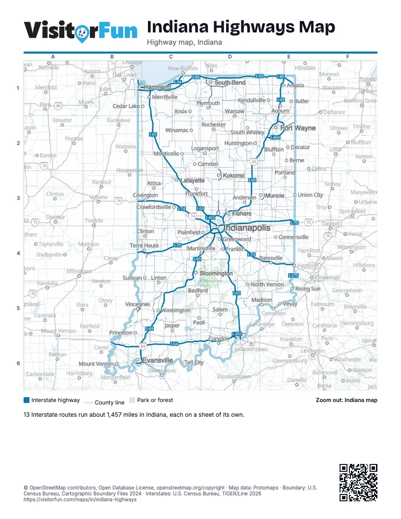
Road maps of Indiana
15 road maps: each Interstate and byway on a sheet of its own.
Highway index of Indiana
Each highway on the sheet and the grid squares it crosses.
- I-64B6, C6, D6
- I-65C1, C2, C3, D3, D4, D5, D6
- I-69B6, C4, C5, C6, D2, D3, D4, E1, E2
- I-70B4, C4, D3, D4, E3
- I-74B3, C3, D3, D4, E4
- I-80B1, C1, D1, E1
- I-90B1, C1, D1, E1
- I-94B1, C1
- I-265D5, D6
- I-275E4
- I-465D3, D4
- I-469E2
- I-865D3
- US 6B1, C1
- US 12C1
- US 20D1
- US 24E2
- US 30E2
- US 31D1, D2, D3
- US 33E2
- US 35D2, D3, E3
- US 40B4, C4
- US 41B1, B5
- US 50B5
- US 52C3, D3, E4
- US 150B5, D6
- US 421D4
- SR 2C1
- SR 3E3
- SR 9D3, D4
- SR 28D3
- SR 37D3
- SR 38D3
- SR 45C4
- SR 46C4
- SR 49C1
- SR 57B6
- SR 62B6, D5, D6
- SR 66B6
- SR 67D3, E3
- SR 331D1
- SR 641C4
- SR 912B1, C1
Places on the map
- Anderson
- Angola
- Attica
- Auburn
- Batesville
- Bedford
- Berne
- Bloomington
- Bluffton
- Butler
- Camden
- Cedar Lake
- Clinton
- Connersville
- Corydon
- Covington
- Crawfordsville
- Decatur
- Evansville
- Fishers
- Fort Wayne
- Frankfort
- Franklin
- Greenwood
- Hammond
- Huntington
- Indianapolis
- Jasper
- Kendallville
- Knox
- Kokomo
- Lafayette
- Linton
- Logansport
- Madison
- Martinsville
- Merrillville
- Monticello
- Mount Vernon
- Muncie
- North Vernon
- Paoli
- Plainfield
- Plymouth
- Portland
- Princeton
- Rising Sun
- Rochester
- Salem
- South Bend
- South Whitley
- Sullivan
- Tell City
- Terre Haute
- Union City
- Vevay
- Vincennes
- Warsaw
- Washington
- Winamac
© OpenStreetMap contributors, Open Database License, openstreetmap.org/copyright · Map data: Protomaps · Boundary: U.S. Census Bureau, Cartographic Boundary Files 2024 · Interstates: U.S. Census Bureau, TIGER/Line 2026















