

Indiana map
New Albany Township map
About 37,652 people live here (Census Bureau, 2024 estimate). The sheet's index lists 300 streets; Charlestown Road, Grant Line Road and North Skyline Drive cross the most grid squares. Things to do inside the boundary: Culbertson Mansion State Historic Site and The Cultural Arts Center.
Open the map (PDF, US Letter)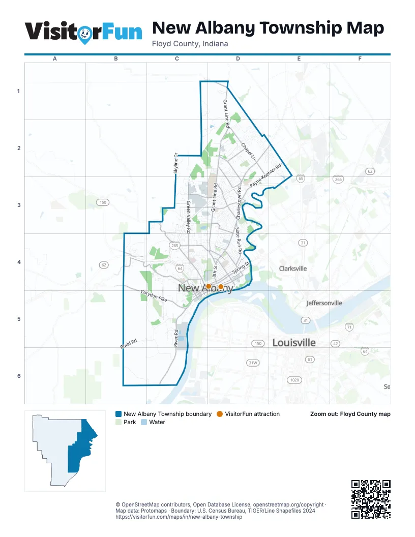
Street index of New Albany Township
Each street on the sheet and the grid squares it crosses.
- Sherman Minton BridgeC5
- Charlestown RoadD2, E2, D3, D4
- River RoadC5, C6
- East Main StreetD4, C5, D5
- East Spring StreetC4, D4
- Vincennes StreetD4
- West Main StreetC5
- Scribner DriveC4, C5
- West Spring StreetC4, C5
- West 5th StreetC4, C5
- Spring StreetD4
- Brown's Station WayD4
- Grant Line RoadD1, D2, D3, D4
- Corydon PikeB4, B5, C5
- State StreetC4, C5, D5
- East Elm StreetC4, D4
- Silver StreetD4
- Paoli PikeC3, C4
- Beechwood AvenueD4
- West Elm StreetC4, C5
- West 4th StreetC5
- Blackiston Mill RoadD3
- State Road 111D1
- Blackiston Mill Road BrdigeD3
- Old Vincennes RoadB4, C4
- Green Valley RoadC2, C3, C4
- Chapel LaneD2
- Payne-Koehler RoadD2, E2, D3
- East Market StreetC4, D4, C5
- Mount Tabor RoadC3, D3
- County Line RoadD1, D2, E2
- Kamer Miller RoadD2, D3
- Saint Joseph RoadD2, D3
- Klerner LaneD3
- Slate Run RoadD3, D4
- Hausfeldt LaneC3, D3
- Cherry StreetC4
- McDonald LaneD3
- East Daisy LaneC4, D4
- East 8th StreetD4
- West 7th StreetC4, C5
- Quarry RoadB4
- West Saint Joe RoadD1
- West Market StreetC4, C5
- West Daisy LaneC4
- Mel Smith RoadD2
- Blackiston BoulevardD3
- Old Highway 62D4
- St Joe HillD1
- Budd RoadB5, C5, B6
- North Skyline DriveC1, D1, C2, D2
- East Oak StreetC4, D4
- Gap Hollow RoadB6, C6
- Kraft CemeteryD3
- Highwater RoadB5, C5
- Captain Frank RoadC4
- Culbertson AvenueC4, D4
- Two Mile LaneC5, C6
- Academy DriveC3, D3
- Chapel Creek TrailD2
- Old Ford RoadD3, D4
- East Water StreetD4, C5, D5
- Indiana AvenueD4
- Mills LaneC3
- Pearl StreetC4, D5
- Bald Knob RoadC2, D2
- Ekin AvenueD4
- Alex Thom DriveC3, D3
- Old Hill RoadB3, B4
- Beeler StreetD4
- McDonald AvenueD4
- Moser Knob RoadC2
- West StreetC4, D4
- East Lobo RidgeE2, E3
- Spickert Knob RoadC3
- Glenmill RoadC3, C4
- Graybrook LaneC4, D4
- Industrial BoulevardC3
- Roanoke AvenueD3, D4
- Fairview Knob RoadD1, D2
- Autumn Hill TrailD2
- Bono RoadC4
- Valley View RoadC4
- Bugaboo LaneD2
- Plantation DriveD2
- Sunset DriveD2, C4
- Jackson StreetC4, D4, C5
- Glenview HeightsC3
- Broekers LaneC5
- Anderson RoadC5
- Floyd StreetD4, C5
- South Skyline DriveC2, C3
- East 15th StreetD4
- East 4th StreetD4, D5
- Apple Blossom DriveC2
- Locust StreetD4
- Bridlewood LaneD2, D3
- West 8th StreetC4, C5
- West Riley RoadB4
- Cobblers Crossing RoadD2, E2
- Kenzig RoadC4
- Rainbow DriveD3
- Dewey StreetD4
- Julian DriveD3
- View PointC4
- Arbor PlaceC3
- University Woods DriveD3
- Cote de ChambordC3
- East 13th StreetD4
- East 9th StreetD4
- Jay StreetD4
- Wildwood LaneC4
- McConnell DriveD2, D3
- East 18th StreetD4
- Danny DriveD2
- Shelby PlaceD4
- Security ParkwayD2
- Castlewood DriveD3
- Country Club DriveC4, D4
- Holz RoadC4
- Lands EndB5, C5
- Vance AvenueD4
- Linda DriveC3, C4
- Shagbark TrailD2
- Park East BoulevardC3
- Silver Run CenterD3
- Schell LaneC3, C4
- White Pine BoulevardD2
- Glenwood WayD1
- Wolf Lake BoulevardE2, E3
- Camp AvenueC4, C5
- Highland AvenueC5
- East 10th StreetD4, D5
- East 11th StreetD4
- Reas LaneC3
- Wabash AvenueD2, D3
- Thomas StreetD4
- Plum Hill WayC2, C3
- Division StreetD4
- East Arrowhead DriveC5
- Sunrise DriveD2
- Barack Obama WayD2
- Lorian BoulevardC3
- Linden StreetC4, D4
- Foundation BoulevardD2
- Progress BoulevardC3
- French Creek DriveC6
- Eagle LaneC4, C5
- Greenfield DriveD3
- Monon AvenueD4
- East Riley RoadB4
- Beharrell AvenueD4
- Lafayette DriveD3
- Allee RoadC3
- Crestview DriveC4
- Korb AvenueD4
- Grandview DriveB4, C4
- Woodbourne DriveD3
- Countryside DriveD3
- Tomahawk LaneC5
- Woodland Lakes DriveB4
- Valley View CourtC4
- Depauw AvenueD4
- Plaza DriveD3
- Rolling Creek DriveC3, D3
- Scheller LaneD3
- Knob AvenueC5
- Albany StreetC4
- Adams StreetC4, C5
- Bank StreetC4, D5
- East 7th StreetD4
- Bell LaneC3
- East 5th StreetD4, D5
- Woodside DriveD3
- Erni AvenueC4
- Galiger Station RoadC5
- Hildreth StreetC4
- Main StreetD4
- Muirfield DriveD3
- Spring AvenueD4
- Pennwood DriveD3
- Mellwood DriveD3
- Lynnwood DriveD3
- Durgee RoadD2
- Pamela DriveC4
- Chanda DriveC5
- Wolfe Trace CourtC4, D4
- Binford RoadC4
- West 6th StreetC4, C5
- Ealy StreetC4
- West Water StreetC5
- Sandalwood DriveD2, E2
- Eastridge DriveD3
- Technology AvenueD3
- West Cottom AvenueC4
- Koehler PlaceE2
- Braeview DriveC4
- Southern DriveD3
- Periwinkle WayE2
- New Albany PlazaC4
- Pickwick DriveD3
- University DriveD3
- Charlestown CrossingD2
- Woodrow AvenueD4
- Chartres StreetD4
- Carver StreetD2
- Riverside DriveD4
- East 6th StreetD4, D5
- Twin Oaks DriveD4
- Caiman CourtD2
- Shelby StreetD4
- Daisy SummitC4
- Powder House LaneC5
- Creek Ridge DriveD3
- West 1st StreetC4, C5
- East 14th StreetD4
- Chapelbrook LaneD2
- Rector LaneD3
- Navajo DriveC3, C4, D4
- Chateau de ChambordC3
- Clearstream CourtC4
- Cherokee DriveC3, C4, D4
- East 3rd StreetD4, D5
- Trimingham RoadC4
- Victoria DriveD2
- Galt StreetD4
- Wynn Gate CourtD3
- Charles Allen SchoolD3
- Creekview CircleD3
- Coes LaneD4
- Plantation CourtD2
- Dalebrook DriveD3
- Earnings WayC3
- Whippoorwill HeightsC3
- Woodmount DriveC4
- Brookhaven RoadD2
- Gus Emmett TrailD2
- Spring Street HillC5
- Cheryl DriveC3
- Hickoryvale DriveD3, D4
- Cooks Creek LaneD1
- Maevi DriveC4
- Payne RoadD2
- Deerwood DriveD3
- Willian LaneC5
- Knob View AvenueD3
- Ellen CourtC4
- Clark StreetD4
- Griffin StreetC4
- Quail Chase DriveD2
- Commerce StreetC4
- Gray Fox DriveD3
- Prestwick SquareD3
- Grace Marie DriveD3
- Silver Creek DriveD3
- Olive StreetC4
- Andres WayB4
- Grenadier DriveD3
- Stone PlaceD3
- Royal Oak CourtD2
- Falls Creek LandingD2
- Homestead DriveD2
- Greenview DriveC3
- Lewis A Endris ParkwayD2
- Roseview TerraceC4
- Wahoo DriveC3, C4
- Baumann Drive SouthC1
- Clover AvenueC4
- Woodfield DriveD3
- Serenity Springs DriveD3
- Lopp AvenueD4
- Fawcett Hill RoadC4
- Wildwood RoadC4
- Armstrong RoadD3
- Chadwood DriveC3
- West 9th StreetC4, C5
- Alumni DriveD3
- Oakland DriveC4
- Carriage LaneC4
- Barrington CourtC3
- Wooded Valley DriveC4
- Louise WayD2
- McLean AvenueD4
- Quail Ridge TrailD2
- Park PlaceC3
- Mill LaneD4
- Oxford DriveD3
- Westwood LaneC4
- Kaufer DriveC3
- Shrader AvenueD4
- Westchester DriveB4
- Tiger BoulevardD3
- Jeffers DriveD2
- Green StreetC4, D4
- Redwood DriveC3, C4
- Royal Lake DriveB4
- Ridgeway AvenueC5
- Millerwood DriveD3
- Meadowview DriveD3
- Terry LaneD4
Things to do on the New Albany Township map
Places on the map
- America/Kentucky/Louisville Timezone
- Anderson Park
- Ash Pond A
- Ash Pond B Landfill
- Baptist Health Floyd
- Binford Park
- Cannon Acres Park
- Cherry Valley Golf Course
- Coal Pile Ash Fill
- Fairmont Elementary School
- Fairview Cemetery
- Falling Run Park
- Grant Line Elementary School
- Green Valley Elementary School
- Griffin Recreation Center
- Holy Trinity Cemetery
- Indiana University Southeast
- Kevin Hammersmith Memorial Park
- Kiwanis Lake
- Kraft-Graceland Cemetery
- Kroger
- Lost Knob
- Meijer
- Mount Tabor Elementary School
- New Albany Dog Park
- New Albany Downtown Historic District
- New Albany Golf Course
- New Albany National Cemetery
- New Albany Plaza
- New Albany Schools
- North Ash Pond Landfill
- Pine Hill
- Primary Ash Pond
- Primary Pond Ash Fill
- Prosser Career Education Center
- Purdue Research Park of Southern Indiana
- River Run Family Water Park
- Sam Peden Community Park
- Scribner Middle School
- Wolf Lake
Next to New Albany Township
- Clarksville map
- Jeffersonville map
- Louisville
© OpenStreetMap contributors, Open Database License, openstreetmap.org/copyright · Map data: Protomaps · Boundary: U.S. Census Bureau, TIGER/Line Shapefiles 2024















