

Indiana map
Spencer County map
About 20,192 people live here (Census Bureau, 2024 estimate). The sheet's index lists 300 streets; Main Street, 4th Street and County Road 100 cross the most grid squares. Things to do inside the boundary: Holiday World & Splashin Safari, Lincoln Boyhood National Memorial and Lincoln State Park.
Open the map (PDF, US Letter)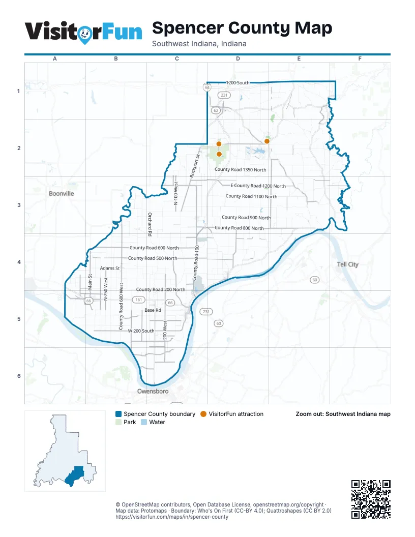
Street index of Spencer County
Each street on the sheet and the grid squares it crosses.
- County Road 100C3, C4, A5, B5, C5
- Main StreetE1, E2, C3, D3, E3, B4, D4, C5
- William H. Natcher BridgeC5
- Sycamore StreetD1, B4, D4, C5
- 5th StreetE1, B4, C5
- Owensboro BridgeC6
- County Road 800 NorthC3, D3, E3
- County Road 600 WestB3, B4, B5
- County Road 800 EastE1, E2, E3
- Old State Road 245D3, D4
- Rockport StreetC2, C3
- West Christmas BoulevardD2
- County Road 1200C3
- County Road 300 EastD1, D2
- Old State Road 45C5
- North Holiday BoulevardD2
- South Old State Road 45C5
- South Washington StreetD1
- East County Road 800 NorthC3, E3
- Main AvenueD4
- County Road 200 NorthC3, A4, B4
- County Road 1000 EastE2, E4
- Mill StreetE1, C2, C5
- East Medcalf StreetD1
- E County Road 225 ED1
- County Road 125 EastC2, D2
- East County Road 1950 NorthD1
- County Road 1200 NorthC3
- County Road 1600 NorthC2, D2
- North 5th StreetC5
- South Lincoln AvenueC5
- West County Road 200 SouthC5
- West Medcalf StreetD1
- State Road 66E3
- West County Road 600 NorthB4, C4
- East County Road 1200 NorthC3, D3, E3, F3
- East County Road 500 NorthC4, D4
- North Main StreetD1, B4, B5
- East County Road 1250 NorthC3, D3, E3, F3
- West 200 SouthB5, C5
- South 200 WestD1, C5, C6
- County Road 500 NorthB4, C4
- South 500 WestD1, B5, B6
- West 300 SouthB5, C5
- West County Road 500 NorthC4
- North 750 WestB4, B5
- Old State Road 66A5, B5
- East County Road 700 NorthC4, D4
- North 200 WestC4, C5
- North 100 WestC2, C3
- County Road 950 EastE1, E2, E3
- North 800 WestB4, B5
- West 100 SouthC5
- South 400 WestB5
- North 975 WestA4, A5
- North 25 WestC3
- West 150 NorthA5, B5
- North County Road 125 WestC4
- West 710 SouthC6
- West 500 SouthC6
- North County Road 100 WestC4, C5
- West 425 SouthB6, C6
- West 50 SouthB5
- Short Johnnytown RoadE1, E2
- West 350 SouthC5
- West 440 SouthB6
- County Road 1150 EastE3
- County Road 1010 EastE1, E3
- North Silverdale RoadC5
- County Road 1450 NorthD2, E2
- County Road 890 EastE2
- North 100 EastC4
- West 560 SouthB6, C6
- West 50 NorthA5, B5, C5
- North 125 WestC2, C3
- West 400 SouthC6
- North 950 WestA5
- West 250 SouthC5
- East County Road 1050 NorthE3
- East 250 NorthC4
- County Road 210 EastD3
- County Road 1125NE3
- County Road 710 SouthC6
- North Washington StreetD1
- North County Road1250 EastE1
- North County Road 900 WestB4
- West 540 SouthB6
- County Road 1175EE3
- County Road 1175NE3
- North Short Johnnytown RoadE2
- County Road 1010EE3
- Macdonald RoadE3
- North 1225 EastE2
- Old State Hwy 66A5
- North County Road 600 EastD1, D2, D3, D4
- East County Road 1100 NorthC3, D3, E3
- East County Road 900 NorthC3, D3, E3, F3
- West County Road 300 NorthA4, B4, C4
- East County Road 1350 NorthC2, D2, E2, F2
- West County Road 200 NorthB4, C4
- North County Road 450 WestB3, B4, B5
- North County Road 700 EastD1, D2, D3
- North County Road 300 EastD1, D2, D3, D4
- East County Road 1400 NorthD2, E2, F2
- East County Road 1000 NorthD3, E3
- North Base RoadC2, C3, C4, C5
- North County Road 700 WestB4, B5
- West Base RoadB5, C5
- North County Road 475 EastD2, D3
- North County Road 550 EastD2, D3, D4
- County Road 2100 NorthD1, E1, F1
- North Orchard RoadC4, C5
- County Road 1000 NorthC3, D3
- East County Road 750 NorthC3, D3
- East County Road 1600 NorthD2, E2
- North County Road 150 EastC2, C3
- North Old State RoadC4
- County Road 150 SouthA5, B5
- North County Road 500 EastD1, D2
- West Eureka RoadB5, C5
- East County Road 1500 NorthC2, E2
- West 1200 SouthD1
- County Road 650 WestB4, B5
- East County Road 1300 NorthD2, E2
- West County Road 900 NorthB3, C3
- North County Road 250 EastD2, D3
- East County Road 350 NorthC4, D4
- North County Road 1100 EastE2, E3
- North County Road 400 WestB3, B4
- County Road 50 SouthA5, B5
- North County Road 550 WestB4
- North 350 WestC4, C5
- North County Road 350 EastD1, D2, D4
- County Road 1700 NorthE2, F2
- West County Road 700 NorthB4, C4
- County Road 700 NorthC4
- East County Road 600 NorthC4, D4, E4
- West County Road 650 NorthB4, C4
- Orchard RoadC3, C4
- South 350 WestC5
- North County Road 500 WestB4, B5
- East County Road 2000 NorthC1, D1
- South County Road 600 WestB5
- County Road 750 WestB5
- East County Road 1700 NorthD2
- East County Road 1550 NorthE2
- County Road 290 SouthA5, B5
- South County Road 800 WestB5
- Adams StreetB4
- West County Road 950 NorthB3, C3
- East County Road 625 NorthD4
- County Road 200 EastC1, D1, C2, C3, C4
- County Road 1175 EastE1, E2
- North County Road 1000 EastE2, E3, E4
- North County Road 150 WestC3, C4
- South County Road 700 WestB5
- County Road 550 NorthB4, C4, D4
- County Road 850 EastE1, E2
- East County Road 400 NorthC4, D4
- North County Road 900 EastE2, E3, E4
- County Road 1050 EastE1, E3
- County Road 675 WestB4, B5
- Monte Cassino RoadE1
- North County Road 200 EastC2, C3, C4
- North County Road 800 EastE3, E4
- West County Road 425 NorthB4, C4
- East County Road 550 NorthC4, D4
- East County Road 950 NorthC3, E3, F3
- North County Road 750 WestB4
- North County Road 1425 EastF2, F3
- North County Road 1200 EastE3
- County Road 225 EastC2, D2, D3
- North County Road 1300 EastE2
- South County Road 100 WestC5
- North County Road 850 EastE3
- South County Road 850 WestB5
- North County Road 50 WestC3, C4
- North County Road 325 WestC3, C4
- South County Road 50 WestC5
- North County Road 225 EastD1, D2
- North County Road 1000 WestA5
- North County Road 850 WestB4
- North County Road 800 WestB4
- County Road 900 NorthB3, C3
- East County Road 1450 NorthD2, E2
- County Road 775 NorthB3, C3
- West County Road 400 NorthB4
- West County Road 350 NorthB4, C4
- Balthazar DriveD2
- Melchoir Drive SouthD2
- East County Road 1475 NorthD2, E2
- County Road 175 EastC2, C3
- West County Road 800 NorthB3, C3
- County Road 300 NorthA4, C4, D4
- County Road 1950 NorthC1, D1, E1, F1
- West County Road 1100 NorthB3, C3
- County Road 1300 NorthD2, E2, F2, E3
- County Road 400 NorthC4, D4
- County Road 450 EastD1, D2
- Vine StreetD1, E2, D4, C5
- Melchoir Drive NorthD2
- North Stones LaneE3
- County Road 325 EastD3
- County Road 275 EastD2, D3, D4
- North County Road 525 WestB3, B4
- North County Road 225 WestC3
- County Road 2160 NorthD1, E1, F1
- County Road 2050 NorthD1, E1
- North County Road 475 WestB3
- County Road 1900 NorthD1, E1
- North County Road 275 EastD2, D3
- County Road 225 WestC3
- East County Road 1900 NorthD1
- North Huffman Mill RoadF2
- County Road 1800 NorthD2
- 4th StreetE1, C2, E3, B4, D4, C5
- 2nd StreetE1, C2, B4, D4
- East County Road 1490 NorthF2
- County Road 375 NorthA4, B4, C4
- West County Road 1300 NorthC2
- 1000 WestA4
- County Road 950 NorthC3
- County Road 1790 NorthE2
- North County Road 1240 EastE3
- County Road 200 WestC3, C4
- County Road 1190 EastE1, E3
- West County Road 975 NorthB3
- County Road 1040 EastE1, E2
- North Gries RoadD1
- Walnut StreetC3, B4, D4, C5
- County Road 400 WestB4, B6
- West County Road 1350 NorthC2
- Mariahhill Ferd RoadD1, E1
- County Road 550 EastD4
- East County Road 1025 NorthE3, F3
- West County Road 1050 NorthC3
- Mariah DriveD1, D2
- Co 290 SouthB5
- County Road 250 NorthA4
- East County Road 1615 NorthE2
- 1930 NorthD1
- East County Road 1460 NorthE2
- County Road 1360 EastF1, F2
- County Road 1650 NorthD2, E2
- North County Road 650 EastD2, D3
- North County Road 575 EastD4
- County Road 700 WestB4, B5
- County Road 175 WestC3, C5, C6
- East County Road 1160 NorthE3
- County Road 1310 NorthE3
- County Road 275 SouthB5, C5
- County Road 875 EastE1, C2
- East County Road 1260 NorthE3
- Melchoir Drive WestD2
- Old United States Highway 231D1
- North County Road 400 EastD3, D4
- County Road 675 NorthD1, D4, E4
- County Road 600 NorthD4
- North County Road 600 WestB5
- E County Road 700 ED3, D4
- West 40 NorthC5
- County Road 150 EastC2, C4
- County Road 310 SouthB5
- North County Road 950 EastE3
- East County Road 1150 NorthE3
- County Road 975 EastE3
- North County Road 250 WestC4
- Prancer DriveD2
- North 400 WestB5
- Ashburn RoadD2, E2
- East County Road 400D4
- County Road 1090 EastE2
- West County Road 785 NorthB3
- County Road 75 SouthA5
- 350ED3
- North County Road 750 EastD3, D4
- County Road 1475 NorthC2
- West County Road 750 NorthC3
- County Road 250 EastD3, D4
- North County Road 450 EastD4
- County Road 2190 NorthE1
- East County Road 1575 NorthC2
- Kaspar DriveD2
- Fisher's Lake RoadE3
- 1st StreetE1, C2, E3, B4
- Kimbell DriveD2
- Church StreetD4
- County Road 1675 NorthD2
- County Road 350ED2
- 7th StreetD4
- Club House RoadD2
- Donder LaneD2
- County Road 925 NorthE3
- County Road 700D2, E2
- County Road 450 NorthB4
- County Road 400 EastD1
- North County Road 625 EastD2
- County Road 50 WestC3, C4, C5
- County Road 475 WestB3, B6
- West More DriveC5
Things to do on the Spencer County map
Places on the map
- Brauns Airport
- Cedar Crest Lake
- Chrisney
- Chrisney Lake
- Christmas Lake
- Coal Knobs
- Dale
- Dale Cemetery
- Dale Reservoir
- Fisher Knobs
- Flint Hill
- Foertsch Airport
- Gentryville
- Grandview
- Grandview Park
- Hanging Rock
- Holiday Drive-in
- Holiday World & Splashin' Safari
- Jim Yellig Park
- Lake Holly
- Lake Lincoln
- Lake Rudolph
- Lincoln Boyhood National Memorial
- Lincoln State Park
- Miller Lake
- Nix Hill
- Noel Lake
- Renshaw Airport
- Rockport
- Saint Meinrad Post Office
- Santa Claus
- Santa Claus Lake
- Santa Claus Post Office
- Sarver Field
- Spencer County Public Library
- Sun Outdoors Lake Rudolph
- Sunset Hill Cemetery
- Town of Grandview
- Trail 5
Next to Spencer County
- Boonville
- Owensboro
- Tell City
© OpenStreetMap contributors, Open Database License, openstreetmap.org/copyright · Map data: Protomaps · Boundary: Who's On First (CC-BY 4.0); Quattroshapes (CC BY 2.0)















