

Indiana map
St. Joseph County map
About 273,744 people live here (Census Bureau, 2024 estimate). The sheet's index lists 90 streets; Indiana Toll Road, Pierce Road and Saint Joseph Valley Parkway cross the most grid squares. Things to do inside the boundary: Notre Dame Stadium and University of Notre Dame.
Open the map (PDF, US Letter)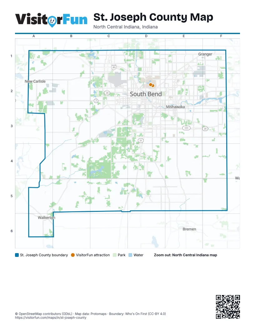
Street index of St. Joseph County
Each street on the sheet and the grid squares it crosses.
- Indiana Toll RoadA1, B1, C1, D1, E1, F1, D2, E2
- Brick RoadC1
- Cleveland RoadC1, D1, E1, F1
- Saint Joseph Valley ParkwayC1, C2, C3, D3, E3, F3
- Dixie WayD1, D2
- Indiana 933D1
- Ironwood RoadD1, D2, D3
- Portage AvenueD1, D2
- Portage RoadD1
- Adams RoadE1, F1
- Capital AvenueE1, E2, E3
- East Cleveland RoadE1
- Edwardsburg HighwayE1
- Grape RoadE1, E2
- North Main StreetE1, D2, E2, B4, B5
- South Bend AvenueE1, D2, E2
- Ash Road;West County Line RoadF1, F2
- Birch RoadF1
- State Line RoadF1
- East Michigan StreetA2, B2, C2
- West Michigan StreetA2
- Western AvenueA2, B2, C2
- Lincolnway WestC2, D2, F2
- Mayflower RoadC2, C3
- North Mayflower RoadC2
- South Mayflower RoadC2
- West Sample StreetC2, D2
- West Western AvenueC2, D2
- Chapin StreetD2
- Charles Martin Sr. DriveD2
- East Angela BoulevardD2
- East Colfax AvenueD2
- East Monroe StreetD2
- East Sample StreetD2
- Edison RoadD2, E2, F2
- Lincoln Way WestD2, E2, F2, D3, E3
- Lincolnway EastD2, F2
- McKinley AvenueD2, E2
- Mishawaka AvenueD2, E2
- North Dr. Martin Luther King Jr. BoulevardD2
- North Eddy StreetD2
- North Ironwood DriveD2, D3
- North Jacob StreetD2
- North Michigan StreetD2
- North William StreetD2
- Prairie AvenueD2, C3, D3
- South Dr. Martin Luther King Jr. BoulevardD2
- South Eddy StreetD2
- South Ironwood DriveD2, D3
- South Main StreetD2, D3
- South Michigan StreetD2, D3
- South William StreetD2
- West LaSalle AvenueD2
- West Marion StreetD2
- West Monroe StreetD2
- Church StreetE2
- Day RoadE2, F2
- East Day RoadE2
- East McKinley AvenueE2
- Lincoln Way EastE2, F2
- McKinley HighwayE2, F2
- North Church StreetE2
- South Church StreetE2, E3
- West Day RoadE2
- West Edison RoadE2
- West McKinley AvenueE2
- West Mishawaka AvenueE2
- County Road 20F2
- Day TrailF2
- Ireland RoadC3, D3, E3
- Liberty HighwayC3, B4
- West Ireland RoadC3, D3
- Dixie HighwayD3, D4, C5, D5
- East Ireland RoadD3, E3
- Kern RoadD3
- Old US 31 SouthD3
- West Chippewa AvenueD3
- Bremen HighwayE3, E4, E5
- Elm RoadE3
- Union StreetE3
- Osborne TrailA4
- Pierce RoadA4, E4, F4, A5, B5, C5, D5, E5
- Laporte TrailA5, A6
- S State StA5, A6
- South State StreetA5, B5, A6
- Indiana StreetA6
- Michigan StreetA6
- Roosevelt RoadA6, B6
- Virginia StreetA6
- Zietler TrailA6
Things to do on the St. Joseph County map
Places on the map
- A Rosie Place
- Allsop Excavating
- AM General Mishawaka Manufactuing Campus
- Amazon AWS Data Center
- Anderson Lake Estates
- Anderson Road
- Andrew Jackson Middle School
- Apostolic Temple Village
- Autumn Lakes Apartments & Townhomes
- Beacon Granger Hospital
- Beacon Heights Apartments
- Belleville Park
- Birch Lake Estates
- Birch Tree Golf Course
- Blackthorn Golf Club
- Blueberry Ranch
- Brownstone Estates
- Buckeye Terminals
- Burke Golf Course
- Cambridge Square Co-Op
- Camp Ray Bird
- Castle Point Apartments
- Chain O' Lakes Gun Club
- Chamberlain Lake
- Chapel Hill Memorial Gardens
- Chet Waggoner Little League
- Chicago Trail Village
- City Plaza
- Clay High School
- Clear Water
- Cleveland-Cliffs Tek and Kote
- Cranberry Estates
- Creekside Terrace
- Deer Park Estates
- Drewrys Brewing
- East Pointe Estates
- East Race
- Eastgate & Lakeside Apartments
- Eberhart Petro Golf Course
- Edcoat
Next to St. Joseph County
- Bremen
© OpenStreetMap contributors (ODbL) · Map data: Protomaps · Boundary: Who's On First (CC-BY 4.0)