

Kansas map
Ellis County map
About 29,007 people live here (Census Bureau, 2024 estimate). The sheet's index lists 300 streets; 310th Avenue, Yocemento Avenue and 370th Avenue cross the most grid squares. Things to do inside the boundary: Hays, Hays Welcome Center and Sternberg Museum of Natural History.
Open the map (PDF, US Letter)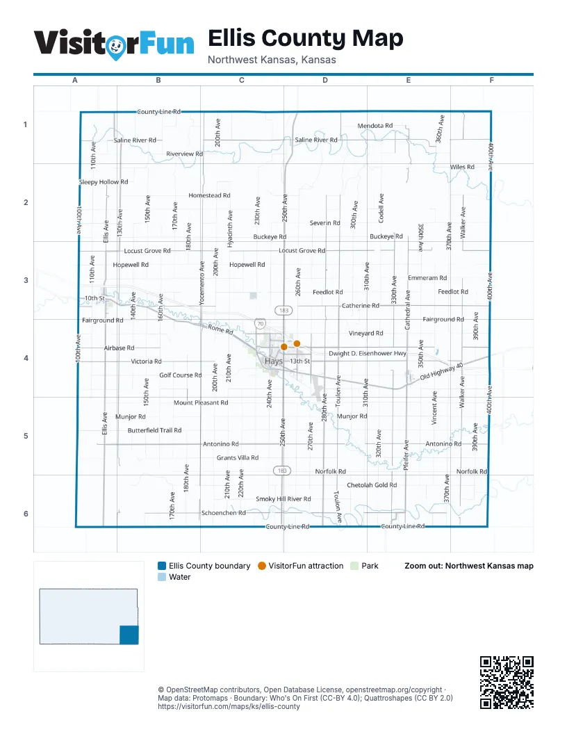
Maps inside Ellis County
1 map inside, from the street map of Ellis County down.
Street index of Ellis County
Each street on the sheet and the grid squares it crosses.
- Dwight D. Eisenhower HighwayA3, B3, C3, C4, D4, E4, F4
- 250th AvenueD1, D2, D3, C4, D4, C5, C6
- US 183 Alt RoadC4
- North Vine StreetC4, D4
- Vine StreetC4, D4
- Old Highway 40A3, B3, B4, C4, D4, E4, F4
- Cathedral AvenueE1, E2, E3, E4
- East 8th StreetA3, C4, D4
- Canterbury DriveD4
- West 27th StreetC4
- East 27th StreetC4, D4
- North Campus DriveC4
- Washington StreetA3, E4
- Old Highway 40 BypassC4, D4
- West 8th StreetA3, C4
- Yocemento AvenueC1, C2, C3, B4, C4, B5, C5, B6
- Antonino RoadA5, B5, C5, D5, E5, F5
- Toulon AvenueD1, D2, D3, D4, D5, D6
- Locust Grove RoadA3, B3, C3, D3, E3, F3
- Saline River RoadA1, B1, C1, D1, E1, F1
- 130th AvenueB1, B2, B3, B4, B5, A6, B6
- 280th AvenueD2, D3, D4, D5, D6
- Walker AvenueF1, F2, F3, F4, F5, F6
- Ellis AvenueA2, A3, A4, A5, A6
- South County Line RoadA6, B6, C6, D6, E6, F6
- 330th AvenueE1, E2, E3, E4, E5, E6
- Catherine RoadA3, B3, C3, D3, E3, F3
- Victoria RoadA4, B4, C4, D4, E4, F4
- Airbase RoadA4, B4, D4, E4, F4
- Schoenchen RoadB6, C6, D6, E6
- Pfeifer AvenueE4, E5, E6
- North County Line RoadA1, B1, C1
- Rome RoadB4, C4
- East 13th StreetA3, C4, D4
- Commerce ParkwayD4
- Main StreetC4, E4, F4, D5
- West 41st StreetC4
- Monroe StreetA3, A4, E4
- 125th AvenueA1
- East 10th StreetA3, C4
- Elm StreetC4, E4
- Hall StreetC4
- East 22nd StreetA3, C4, D4
- West 10th StreetA3, C4, D4, E4
- 22nd StreetD4
- 33rd StreetC4
- Sarratov StreetE6
- West 13th StreetA3, C4
- East 32nd StreetC4, D4
- Ellis Palco RoadB1
- County Road 320E6
- Noose RoadC4
- 310th AvenueD1, E1, D2, E2, D3, E3, D4, E4, D5, D6
- Hopewell RoadA3, B3, C3, D3, E3, F3
- 370th AvenueE1, F1, E2, E3, E4, F4, E5, E6
- Munjor RoadA5, B5, C5, D5, E5, F5
- Mount Pleasant RoadA5, B5, C5, D5, E5, F5
- 200th AvenueC1, C2, C3, C4, C5, C6
- Butterfield Trail RoadA5, B5, C5, D5, E5, F5
- Emmeram RoadA3, B3, C3, D3, E3, F3
- Grants Villa RoadA5, B5, C5, D5, E5, F5
- Feedlot RoadA3, B3, C3, D3, E3, F3
- Chetolah Gold RoadB5, B6, C6, D6, E6, F6
- 150th AvenueB1, B2, B3, B4, B5, B6
- 300th AvenueD2, D3, D4, D5, D6
- Norfolk RoadB5, C5, D5, E5, F5
- Buckeye RoadA2, B2, C2, D2, E2
- Golf Course RoadA4, B4, C4, D4, E4, F4
- 230th AvenueC1, D1, C2, C3, C4, C5, C6
- Fairground RoadF3, A4, B4, C4, D4, E4, F4
- 170th AvenueB1, B2, B3, B4, B5, B6
- 160th AvenueB1, B2, B3, B4, B5, B6
- 400th AvenueF1, F2, F3, F4, F5
- 240th AvenueC1, C2, C3, C4, C5, C6
- Vineyard RoadA4, B4, C4, D4, E4, F4
- 350th AvenueE2, E3, E4, E5, E6
- 260th AvenueD2, D3, D4, D5, D6
- Spring Hill RoadA4, B4, C4, D4, E4, F4
- 110th AvenueA1, A2, A3, A4, A5
- 100th AvenueA1, A2, A3, A4, A5, A6
- Vincent AvenueE1, E2, E3, E4, E5, E6
- Severin RoadA2, B2, C2, D2, E2, F2
- 210th AvenueC1, C3, C4, C5, C6
- 180th AvenueB1, B2, B3, B4, B5, B6
- 140th AvenueB1, B2, B3, B4, B5
- Homestead RoadB2, C2, D2, E2, F2
- 390th AvenueF2, F3, F4, F5, F6
- Saint John - Saint Andrew RoadA2, B2, C2, D2, E2
- 270th AvenueD2, D3, D4, D5, D6
- Codell AvenueE1, E2, E3
- 320th AvenueE4, E5, E6
- 220th AvenueC3, C4, C5, C6
- Smoky Hill River RoadC6, D6, F6
- Hyacinth AvenueC2, C3
- Riverview RoadA1, B1, C1, E1
- Wiles RoadE1, A2, B2, E2, F2
- Mendota RoadA1, B1, C1, D1, E1
- Horse Thief Canyon AvenueD1, D2
- Sleepy Hollow RoadA2, B2, C2
- Dean Hill AvenueC1, D1, C2, D2
- Hadley Range AvenueD1, D2
- 360th AvenueE1
- Walnut StreetA3, C4, F4
- General Custer RoadD4
- Reservation RoadC4, D4
- Ash StreetC4, E4
- 245th AvenueC6
- Fort StreetC4
- Oak StreetC4, E4, C6
- East 17th StreetA3, C4, D4
- 335th AvenueE1, E6
- Ranch RoadD5
- East 7th StreetA3, C4, D4
- West 12th StreetA3, C4
- Canal BoulevardC4
- General Hays RoadD4
- East 6th StreetA3, C4, D4
- Bison RoadC4, D4
- Allen StreetC4, E4
- East 15th StreetA3, C4, D4
- Thunderbird DriveC4
- 305th AvenueD3, D4
- East 19th StreetA3, C4, D4
- West 37th StreetC4, D4
- Pine StreetC4
- East 12th StreetA3, C4
- West 11th StreetA3, C4, E4
- Frontage RoadC4, D4
- Jefferson StreetA3, E4
- West 48th StreetC4, D4
- Donald DriveD4
- Haney DriveD4
- East 11th StreetA3, C4
- Felten DriveD4
- Dorrance StreetA3
- East 29th StreetC4, D4
- 41st StreetD4
- East 5th StreetA3, C4
- East 9th StreetA3, C4, D4
- 55th StreetD4
- 120th AvenueA1
- 355th AvenueE6
- Country LaneC4
- 277th AvenueD3
- Pheasant RoadF6
- Lelyn AvenueE4
- West 55th StreetC4, D4
- East 26th StreetC4, D4
- Milner StreetC4
- Lincoln DriveC4
- East 20th StreetA3, C4, D4
- Hillcrest DriveC4
- East 21st StreetC4, D4
- West 15th StreetA3, C4
- Gustad DriveC4
- Indian TrailD4
- West 4th StreetA3, C4, E4
- Maple StreetA3, C4
- East 18th StreetA3, C4, D4
- Spruce StreetA3, C4
- East 14th StreetA3, C4, D4
- 315th AvenueE2
- West 6th StreetA3, C4
- Madison StreetA3
- Willow StreetC4
- Roth AvenueC4
- Marjorie DriveD4
- East 25th StreetC4, D4
- Hickory StreetC4, E4
- Henry DriveD4
- West 29th StreetC4
- Sherman AvenueD4
- 10th StreetE4
- East 24th StreetC4, D4
- Grant StreetE4, C6
- Skyline DriveC4
- Cottonwood StreetA3
- 12th StreetD4, E4
- 3rd StreetC4, E4, C5
- East 16th StreetA3, C4
- West 14th StreetA3, C4
- West 32nd StreetC4
- West 3rd StreetA3, C4
- West 36th StreetC4
- Douglas DriveD4
- Lincoln RoadE4, F5
- North Front StreetC6
- 390th RoadF4
- West 35th StreetC4
- West 20th StreetC4
- Kazan StreetD5
- Centennial BoulevardD4
- Fairway DriveC4
- West 23rd StreetC4
- Wheatland AvenueD4
- Barclay DriveD4
- West 7th StreetA3, C4
- West 24th StreetC4
- West 17th StreetC4
- Golden Belt DriveD4
- West 5th StreetA3, C4
- Cedar StreetC4, E4
- Federal StreetC4
- East 33rd StreetD4
- West 43rd StreetC4
- West 16th StreetC4
- 1st StreetC4, E4, F4, C5
- West 45th StreetC4
- Iron StreetE4
- Broadway AvenueD4
- Eisenhower RoadD4
- Mac Arthur RoadD4
- Marshall RoadD4
- West 21st StreetC4
- Sternberg DriveD4
- Kansas StreetE4, E6
- Dwight DriveC4
- Augusta LaneC4
- Postrock DriveD4
- Grand StreetC4
- 8th StreetE4
- Saint Jacob StreetE6
- Saeretza StreetE6
- West 19th StreetC4
- West 38th StreetC4
- Balta RoadF4
- Leiker RoadD4
- Walters RoadF5
- Summer LaneC4
- 285th AvenueD4
- Buffalo AvenueD4
- Cottonwood LaneC4
- Virginia DriveD4
- West 9th StreetA3, C4
- Holmes RoadD4
- Anthony DriveD4
- Western Plains DriveD4
- Agnes DriveD4
- East 30th StreetD4
- Drum AvenueD4
- Oakmont StreetC4
- Downing AvenueD4
- Fauteux StreetA3
- 13th StreetE4
- 11 RoadC1
- CathedralD4
- Metro LaneD4
- Moscony StreetE6
- East 23rd StreetC4, D4
- 2nd StreetC4, E4, C5
- Saint John StreetD3
- 6th StreetE4
- West 28th StreetC4
- Cheyenne StreetC6
- East 43rd StreetC4, D4
- West 34th StreetC4
- Taylor StreetA3
- Ball Park RoadC4, E4
- East 4th StreetA3, C4
- Robins RoadD4
- Harvest RoadD4
- Stonecrest RoadC4
- Saint Catherine StreetD3
- 11th StreetE4
- Lawrence DriveD4
- 45th StreetC4, D4
- Pershing DriveC4
- West 25th StreetC4
- Timber DriveD4
- Moscow StreetD5
- 4th StreetE4, C5
- Samara StreetD5
- Autumn LaneC4
- Arapahoe StreetC6
- Sunflower DriveD4
- Smoky Hill DriveC4
- Norman DriveE4
- Decker RoadF3
- Craig StreetF4
- Riley StreetC4
- Fern StreetE4
- Petersburg StreetD5
- Northridge DriveC4
- Country Club DriveC4
- East 27th Street TerraceD4
- Saint Martin StreetD3
- Skyline CourtC4
- Lakeview StreetA3
- State StreetC4, F4
- Saint Alphonsus StreetD3
- Lewis DriveC4
- Maxwell DriveE4
- Grant AvenueD4
- Epworth StreetD4
- Thunderbird CircleC4
- Motz AvenueD4
- Main Street TerraceC4
- Millstone RoadC4
- Saint Anton StreetD3
- Saint Leo StreetD3
Things to do on the Ellis County map
Places on the map
- Aubel Bickle Park
- Auto World
- Bickle-Schmidt Sports Complex
- Big Creek Crossing
- Camber Hays - Children's Mental Health Hospital
- Creek Side Resort
- Dinkel Airport
- Dr. Howard Reynolds Nature Trails
- Dusty Glassman Ballfields
- Ellis
- Ellis County Fairgrounds
- Fort Hays Historic Site
- Fort Hays Memorial Gardens
- Fort Hays State University
- Frontier Historical Park
- Hays
- Hays Dog Park
- Hays Medical Center
- Hays Municipal Golf Course
- K-State Research and Extension
- Lewis Auto Group
- Mount Allen Cemetery
- Mount Hope Cemetery
- Northridge Shopping Center
- Philip Ranch Airport
- Pratt Optimist Soccer Fields
- Rans Airport
- Rohr Jacobs Lake
- RPM Speedway
- Saint Joseph Cemetery
- Schoenchen
- Smoky Hill Country Club
- Stecklein Field
- Sunrise Park
- SuperDARN (Fort Hays East)
- SuperDARN (Fort Hays West)
- Victoria
- Victoria High School
- Vineyard Park Nature Area
© OpenStreetMap contributors, Open Database License, openstreetmap.org/copyright · Map data: Protomaps · Boundary: Who's On First (CC-BY 4.0); Quattroshapes (CC BY 2.0)















