

Kansas map
Hays map
About 21,213 people live here (Census Bureau, 2024 estimate). The sheet's index lists 255 streets; US 183 Alt Road, General Hays Road and Fort Street cross the most grid squares. Things to do inside the boundary: Hays Welcome Center and Sternberg Museum of Natural History.
Open the map (PDF, US Letter)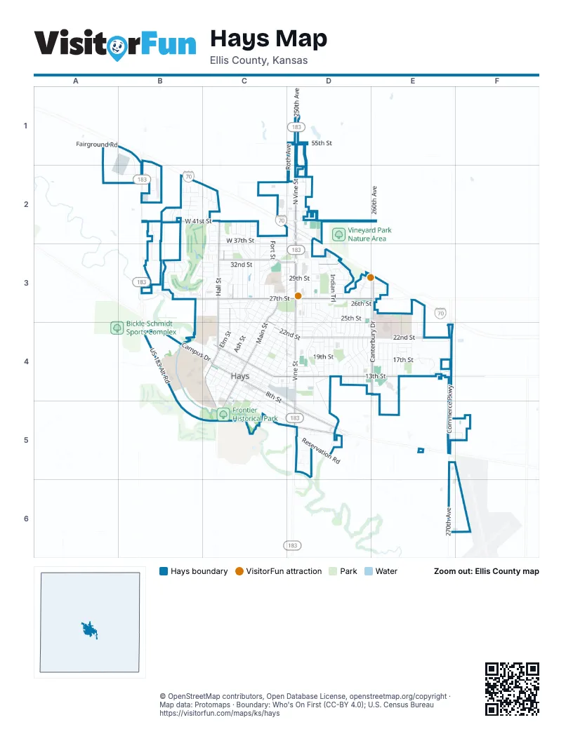
Street index of Hays
Each street on the sheet and the grid squares it crosses.
- Fairground RoadA1, B1, B2
- US 183 Alt RoadB1, B2, B4, B5, C5, D5
- 250th AvenueD1
- 55th StreetD1
- General Hays RoadD1, D2, D3, D4
- North Vine StreetD1, D2, D3
- Roth AvenueD1, D2
- West 55th StreetD1
- Adams DriveB2
- Hoover DriveB2
- Jefferson DriveB2
- Post Rock RoadB2
- Smoky Hill DriveB2
- Thunderbird DriveB2, B3
- Truman CircleB2
- Vista DriveB2, C2
- Washington CircleB2
- West 41st StreetB2, C2
- West 42nd StreetB2
- West 43rd StreetB2, C2, D2
- West 44th StreetB2
- West 45th StreetB2, C2
- West 46th StreetB2
- 240th AvenueC2
- 45th StreetC2, D2
- Autumn LaneC2
- Canal BoulevardC2, C3
- Country LaneC2, C3
- Danby LaneC2
- Dwight D. Eisenhower HighwayC2, D2
- Fairway DriveC2, C3
- Fillmore DriveC2
- Fort StreetC2, C3, C4, C5
- Hall StreetC2, C3, C4
- Harrison StreetC2
- Hillcrest DriveC2, C3
- J P DriveC2
- Jagger CourtC2
- Larned CircleC2
- Lincoln DriveC2, C3, C4
- Mopar DriveC2, D2
- Newton CircleC2
- Summer LaneC2, C3
- West 37th StreetC2, D2
- West 38th StreetC2, D2
- West 39th StreetC2
- West 40th StreetC2
- Willow StreetC2, C3
- 41rst StreetD2
- 41st StreetD2, E2
- East 43rd StreetD2
- Frontage RoadD2, D3
- Sherman AvenueD2, D3
- Skyline DriveD2, C3, D3
- West 48th StreetD2
- 260th AvenueE2
- Vineyard RoadE2
- Amhurst StreetB3, C3
- Augusta LaneB3, C3
- Castillian BoulevardB3
- Cherry Hill DriveB3
- Colonial StreetB3, C3
- Columbine DriveB3
- Country Club DriveB3, C3
- Englewood StreetB3
- Greenbriar LaneB3
- Oakmont StreetB3, C3
- Olympic LaneB3, C3
- Tam O Shanter DriveB3
- Thunderbird CircleB3
- Thunderbird CourtB3
- West 27th StreetB3, C3
- West 28th StreetB3, C3
- West 29th StreetB3, C3
- West 30th StreetB3, C3
- 33rd StreetC3
- Ash StreetC3, C4, C5
- Chaumont DriveC3
- Circle DriveC3, D3
- Clubhouse DriveC3
- Cottonwood LaneC3
- East 22nd StreetC3, C4, D4, E4
- East 23rd StreetC3, C4, D4
- East 24th StreetC3, D4, E4
- East 25th StreetC3, D3, E3
- East 25th Street TerraceC3, D3
- East 26th StreetC3, D3, E3
- East 27th StreetC3, D3, E3
- East 29th StreetC3, D3, E3
- East 32nd StreetC3, D3
- Eldorado LaneC3
- Elm StreetC3, C4, C5
- Forest Dunes DriveC3
- Hickory StreetC3
- Main StreetC3, C4, C5
- Main Street TerraceC3, C4
- Northridge CourtC3
- Northridge DriveC3, D3
- Oak StreetC3, C4, C5
- Pershing DriveC3, C4
- Pine StreetC3, D3, C4, C5
- Pine Valley DriveC3
- Pinehurst StreetC3
- Plum StreetC3
- Skyline CourtC3
- Torrey Pines DriveC3
- Turnberry LaneC3
- Walnut StreetC3, C4
- West 20th StreetC3, C4
- West 21st StreetC3, C4
- West 22nd StreetC3
- West 23rd StreetC3
- West 24th StreetC3
- West 25th StreetC3
- West 26th StreetC3
- West 31st StreetC3
- West 32nd StreetC3
- West 34th StreetC3
- West 35th StreetC3, D3
- West 36th StreetC3, D3
- Woodrow CourtC3
- Barclay DriveD3
- Broadway AvenueD3
- Centennial BoulevardD3, D4
- Donald DriveD3, D4
- East 27th Street TerraceD3
- East 28th StreetD3
- East 28th Street TerraceD3
- East 30th StreetD3
- East 31st StreetD3
- East 33rd StreetD3
- Epworth StreetD3
- Felten DriveD3, D4
- General Custer RoadD3, D4, D5
- General Hancock RoadD3
- General Lawton RoadD3
- Grant AvenueD3
- Haney DriveD3, D4
- Henry DriveD3, D4
- Indian TrailD3, D4
- Marjorie DriveD3, D4
- Motz AvenueD3, D4
- Plaza AvenueD3
- Roosevelt AvenueD3
- Schwaller AvenueD3
- Sternberg CourtD3
- Sternberg DriveD3
- Timber DriveD3, D4
- Trinity driveD3
- Vine StreetD3, D4, D5
- Virginia DriveD3, D4
- Canterbury DriveE3, E4
- Metro LaneE3
- Patio DriveE3
- Wheatland AvenueE3, E4
- Wheatland DriveE3
- 230th AvenueB4
- Agnew LaneB4
- College DriveB4
- Custer DriveB4
- Dwight DriveB4, C4
- Fort Hays State CollegeB4
- Gustad DriveB4
- Lewis DriveB4, C4, C5
- Lyman DriveB4
- North Campus DriveB4, C4
- South Campus DriveB4, C4
- West 12th StreetB4, C4
- Allen StreetC4, D4, C5
- East 10th StreetC4
- East 11th StreetC4, D4
- East 12th StreetC4, D4
- East 13th StreetC4, D4, E4
- East 14th StreetC4, E4
- East 15th StreetC4, D4, E4
- East 16th StreetC4, D4
- East 17th StreetC4, D4, E4
- East 18th StreetC4, D4
- East 19th StreetC4, D4, E4
- East 20th StreetC4, D4, E4
- East 21st StreetC4, D4, E4
- East 4th StreetC4, C5
- East 5th StreetC4, C5, D5
- East 6th StreetC4, C5, D5
- East 7th StreetC4, C5, D5
- East 8th StreetC4, D5
- East 9th StreetC4
- Halladay StreetC4
- Highland AvenueC4
- Maple StreetC4
- Milner StreetC4, D4, C5
- Mission MountC4
- Montgomery StreetC4, D4
- Oak Street TerraceC4
- Park StreetC4
- Pershing CourtC4
- Riley StreetC4, C5
- Spruce StreetC4
- Tamarac CircleC4
- West 10th StreetC4
- West 11th StreetC4
- West 13th StreetC4
- West 14th StreetC4
- West 15th StreetC4
- West 16th StreetC4
- West 17th StreetC4
- West 18th StreetC4
- West 19th StreetC4
- West 2nd StreetC4
- West 3rd StreetC4
- West 4th StreetC4
- West 5th StreetC4
- West 6th StreetC4
- West 7th StreetC4
- West 8th StreetC4
- West 9th StreetC4
- Brookside DriveD4
- Cedar StreetD4
- Cody AvenueD4
- Dechant RoadD4
- Douglas DriveD4
- Downing AvenueD4
- Drum AvenueD4
- Eisenhower RoadD4
- Farley AvenueD4
- Holmes RoadD4
- Ida LaneD4, E4
- Lawrence DriveD4
- Longfellow RoadD4
- Mac Arthur RoadD4
- Marshall RoadD4
- Steven DriveD4
- Sunset TrailD4
- Whittier RoadD4
- 12th StreetE4
- 22nd StreetE4
- Agnes DriveE4
- Anthony DriveE4
- Commerce ParkwayE4, E5
- Cooper Creek CourtE4
- Golden Belt DriveE4
- Harvest RoadE4
- Judith DriveE4
- Tallgrass DriveE4
- Volga DriveE4
- Western Plains DriveE4
- Golf Course RoadB5
- Ball Park RoadC5
- Santa FeC5
- West 1st StreetC5
- Old Highway 40D5
- Old Highway 40 BypassD5
- Reservation RoadD5
- Southridge DriveD5
- 270th AvenueE6
Things to do on the Hays map
Places on the map
- 12th Street Auditorium
- 8th Street Liquor
- 9th Street Diner
- abc Seamless Steel Siding & Gutters
- Ace Hardware
- Advance Auto Parts
- Aikido of Northwest Kansas
- AmericInn
- Applebee's
- Arc of the Central Plains
- Arc of the Central Plains Activity Center
- Arcade 11
- Ashley HomeStore
- Aubel Bickle North Field
- Aubel Bickle Park
- Aubel Bickle Southeast Field
- Aubel Bickle Southwest Field
- Augustine's Bakery
- Auto World
- AutoZone
- avid Hotel
- Bank of Hays
- Bargain Hut
- Baymont Inn & Suites Hays
- Big Creek Crossing
- Camber Hays - Children's Mental Health Hospital
- Dusty Glassman Ballfields
- Fort Hays State University
- Frontier Historical Park
- Hays Medical Center
- Lewis Auto Group
- Mount Allen Cemetery
- Northridge Shopping Center
- Pratt Optimist Soccer Fields
- Rans Airport
- Saint Joseph Cemetery
- Smoky Hill Country Club
- Sunrise Park
- Walmart Supercenter
© OpenStreetMap contributors, Open Database License, openstreetmap.org/copyright · Map data: Protomaps · Boundary: Who's On First (CC-BY 4.0); U.S. Census Bureau















