

Kansas map
Emporia map
About 24,354 people live here (Census Bureau, 2024 estimate). The sheet's index lists 300 streets; Kansas Turnpike, West 6th Avenue and West 12th Avenue cross the most grid squares. Things to do inside the boundary: National Teachers Hall of Fame.
Open the map (PDF, US Letter)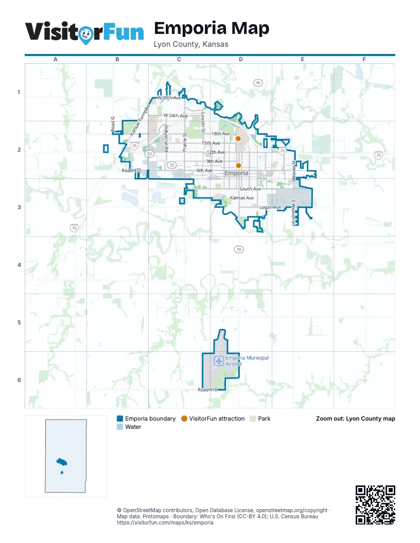
Street index of Emporia
Each street on the sheet and the grid squares it crosses.
- Kansas TurnpikeB1, C1, B2
- West 6th AvenueB2, C2, D2
- East 6th AvenueD2, E2
- West 12th AvenueB2, C2, D2
- Prairie StreetC1, C2
- Merchant StreetD2, D3
- West 7th AvenueC2, D2
- West South AvenueC3, D3
- West 5th AvenueC2, D2
- Industrial RoadC1, C2
- East 12th AvenueD2, E2
- Commercial StreetD2, D3
- East 7th AvenueD2, E2
- South Commercial StreetD3
- East 5th AvenueD2, E2
- Burlingame RoadE2
- Industrial StreetC2
- Road GB2
- West 15th AvenueB2, C2, D2
- West 18th AvenueB2, C2, D2
- East South AvenueD3, E3
- East Logan AvenueD3, E3
- West 9th AvenueC2, D2
- Graphic Arts RoadB1, B2, C2
- West 24th AvenueB1, C1, C2
- Lincoln StreetC1, C2
- Rural StreetD2, D3
- State StreetD2, D3
- East StreetD2, D3
- Exchange StreetD2, D3
- Peyton StreetD2, D3
- Mechanic StreetD2, D3
- Weaver StreetE2, E3
- Chestnut StreetD2
- West 30th AvenueC1
- South Weaver StreetE3
- Whildin StreetE2, E3
- West 4th AvenueD2
- Road 110C6
- Coronado AvenueC1
- South East StreetD3
- Road 180B2
- East 4th AvenueD2
- South Prairie StreetC3
- West 18th StreetC2
- Overlander StreetB2
- Road 170B2
- West StreetD2, D3
- Market StreetD2, D3
- Sylvan StreetD2, D3
- Neosho StreetD2, D3
- East 9th AvenueD2, E2
- Cottonwood StreetD2, D3
- Congress StreetD2, D3
- Constitution StreetD2, D3
- Union StreetD2, D3
- Sunnyslope StreetC2, C3
- West 8th AvenueC2, D2
- East 10th AvenueD2, E2
- East 18th AvenueD2
- Garfield StreetC2, C3
- Whittier StreetD2
- Morningside DriveC1, D1, D2
- South Exchange StreetD3
- Luther StreetC2
- Woodland StreetC2
- Lawrence StreetD2
- Walnut StreetD2
- West Copley AvenueD3
- Graham StreetC2, C3
- Penny LaneE3
- Thompson StreetC2
- Freight RoadC3, D3
- Morse RoadD2, E3
- Elm StreetC2
- East 11th AvenueD2
- Oak StreetC2
- Jones DriveC1, C2
- Homewood StreetE2, E3
- East 1st AvenueD3
- Arundel StreetC2
- Warren WayE3
- West 11th AvenueC2, D2
- West 13th AvenueC2, D2
- Wilson StreetC2, C3
- West 2nd AvenueD3
- Grand StreetC2
- East Kansas AvenueD3
- South Congress StreetD3
- West Randolph AvenueD3
- East Potwin AvenueD3
- South Cottonwood StreetD3
- South Market StreetD3
- South Union StreetD3
- West 1st AvenueD3
- Lakeview StreetD2
- South Mechanic StreetD3
- East 2nd AvenueD3
- West 10th AvenueD2
- Washington StreetD2
- East 8th AvenueD2
- Sherman StreetC2, C3
- South Merchant StreetD3
- Carter StreetE2, E3
- Huntington RoadC2, D2
- Watson StreetD2
- Center StreetD2
- Highland StreetD2
- Grove AvenueC2, D2
- West Ridge DriveB1, C1
- Road M5E3
- Bel-Aire DriveC2
- Oxford DriveC2, D2
- Rio Vista DriveC1
- Gavin RoadD3
- South West StreetD3
- Wanamaka RoadE3
- Melrose PlaceC2
- Cherokee LaneC1, D1
- Jones AvenueC1, C2
- Briarcliff LaneC1, C2
- Sherwood WayD2
- Wooster DriveD2
- Lakeridge RoadC1
- West Kansas AvenueD3
- Canterbury RoadD2
- Dorset DriveE2, E3
- Deerbrook LaneB2
- West 21st AvenueB2, C2
- West 22nd AvenueB2, C2
- Crestview DriveC1
- South Sylvan StreetD3
- Hillcrest DriveC1, C2
- Drury LaneC1, C2, D2
- Casa Loma DriveC1
- Monterey DriveC1
- Sunrise DriveE2
- Soden RoadD3
- Meadowlark LaneC2
- Eaglecrest DriveC2
- West Logan AvenueD3
- Mount Vernon TerraceB1, B2
- West View DriveC1
- East Copley AvenueD3
- Santa Fe Trail RoadC2
- Flint RoadC2
- Dover RoadD2
- Funston StreetC2, C3
- Trusler RoadD2
- Fanestil DriveD1, D2
- C of E DriveC2, D2
- Sonora DriveC1
- Mohawk DriveC1, D1
- Mary StreetE2
- Anderson StreetC2
- Berkeley RoadD2
- Burns StreetC2
- Henry StreetC2
- Frontier WayC2
- Hatcher StreetC2
- Road JC1
- Wheeler StreetC2
- Stanton StreetC2
- East Wilman CourtD2
- Topeka StreetD2
- Scott StreetC2
- Linn AvenueE3
- Calle de LomaC1
- South Constitution StreetD3
- South Neosho StreetD3
- South State StreetD3
- Old Manor RoadC2
- Holiday DriveC2
- Redwood AvenueC1
- Arrowhead DriveC2
- South Walnut StreetD3
- Belmont DriveE2
- South Pine StreetC3
- Lantern LaneC2
- West 20th Park PlaceC2
- East 13th AvenueD2
- Maplecrest DriveC2
- Morse DriveD2
- Riley AvenueD2, E2
- Wiltshire LaneC2
- South Arundel StreetC3
- West Lake DriveC1
- East 15th AvenueD2
- Sutton PlaceC2
- Road 120D6
- Michelle StreetE2
- Eveningside DriveE2, E3
- Candlewood DriveC1, C2
- Hidden Lakes DriveC1
- Trailridge RoadC2
- Riverview DriveD3
- Timmerman DriveC1
- Del Oso DriveC1
- Willow LaneC1
- Norton AvenueD3
- Stratford DriveC2
- East 14th AvenueD2
- Janice StreetC2
- Prairie LaneC2
- Presby DriveC2
- 3rd AvenueC3, D3
- Yucca LaneD2
- Quail Creek RoadD3
- Harcourt DriveE2
- Regency DriveC2
- Apple DriveC1
- Twilight DriveE3
- Waverly WayE2
- Triplett DriveD2
- Ridgeway RoadE2
- Mayfair StreetD2
- Valley DriveD3
- East Randolph AvenueD3
- La-Jara LaneC2
- Antler RidgeB2
- Trowman WayC2
- Cambridge DriveE2
- Eastgate PlazaD3
- Bayfront DriveC1
- Belmont CourtC2
- Melody LaneC2
- Park AvenueC2
- Wild Turkey RoadD3
- South Rural StreetD3
- South Lawrence StreetD3
- West Wilman CourtD2
- Corinth StreetE2
- Moonlight CircleE2, E3
- Sheridan CourtD2
- College DriveD2
- Williby AvenueC2
- South Parkway CourtC1
- Turner RoadD2
- La Salle DriveE2
- Prairie Park LaneC2
- South Chestnut StreetD3
- West 20th AvenueB2
- East Norton AvenueD3
- Twin Lakes DriveC1
- Dove RunD3
- Navajo TrailC1
- Magic Circle DriveC2
- Loma Vista DriveC1
- Clark StreetE2
- Sunset Lake DriveC1
- Oakes DriveB2
- South Washington StreetD3
- Randolph RoadD3
- Buttonwood RoadE2
- Rees RoadC2
- Goura PlaceE2
- Washington DriveD2
- Exchange CourtD2
- Hilltop DriveC2
- West Pond DriveC2
- Gloria StreetC2
- Tomahawk RoadC2
- Caribou LaneB2
- Morse LaneE3
- South ParkwayC1
- West View TerraceC1
- Whitetail LaneB2
- Kellog Circle DriveD2
- 29th TerraceC1
- West Washington Park DriveD2
- Derecho CourtC1
- Delane DriveC2
- Mava AvenueC2
- Sean StreetC2
- Aspen DriveD3
- West Potwin AvenueD3
- Diane AvenueC2
- Hickory LaneC1
- Patrick StreetC2
- West 23rd AvenueC2
- Schaeffer WayC2
- SuttonC2
- Beverly StreetC2
- Peyton DriveD2
- Martin DriveB2
- Sunflower WayD2, E2
- Red Wheat DriveD2, E2
- Albert StreetC2
- Greenbriar DriveC1
- South SylvanD3
- Spring Green StreetE2
- Apache RoadC1
- Norkay DriveE2
- South Walnut Grove DriveD3
- West 14th AvenueD2
- West 3rd AvenueD3
- Cherokee CourtD1
- Sherbrook DriveC2
- Donelson DriveE2
- Comanche WayD1
Things to do on the Emporia map
Places on the map
- ALDI
- AutoZone
- BNSF Emporia Yard
- Braum's
- Buck Fund Dog Park
- Burger King
- Campus Woods
- Champions Landing
- College of Emporia Park
- David Traylor Zoo
- DeBauge Family Sports Complex
- Dryer Park
- Emporia City Library
- Emporia Golf Course
- Emporia High School
- Emporia Middle School
- Emporia Municipal Airport
- Emporia Post Office
- Emporia State Univeristy
- Flint Hills Mall
- Flying J Travel Center
- Hammond Park
- Jones Aquatic Center
- Jones Park
- King Lake
- Lowther Field
- Lyon County Fairgrounds
- Maplewood Cemetery
- Memorial Lawn Cemetery
- Newman Regional Health Center
- NR Junction
- Peter Pan Park
- Riverside Elementary School
- Soden's Grove Park
- Southwest Santa Fe Park
- Timmerman Elementary School
- Trusler Sports Complex
- Twelfth Avenue Baptist Church
- Whittier Park
© OpenStreetMap contributors, Open Database License, openstreetmap.org/copyright · Map data: Protomaps · Boundary: Who's On First (CC-BY 4.0); U.S. Census Bureau















