

Kansas map
Lyon County map
About 32,520 people live here (Census Bureau, 2024 estimate). The sheet's index lists 300 streets; Kansas Turnpike, Road M and Road West cross the most grid squares. Things to do inside the boundary: Emporia and National Teachers Hall of Fame.
Open the map (PDF, US Letter)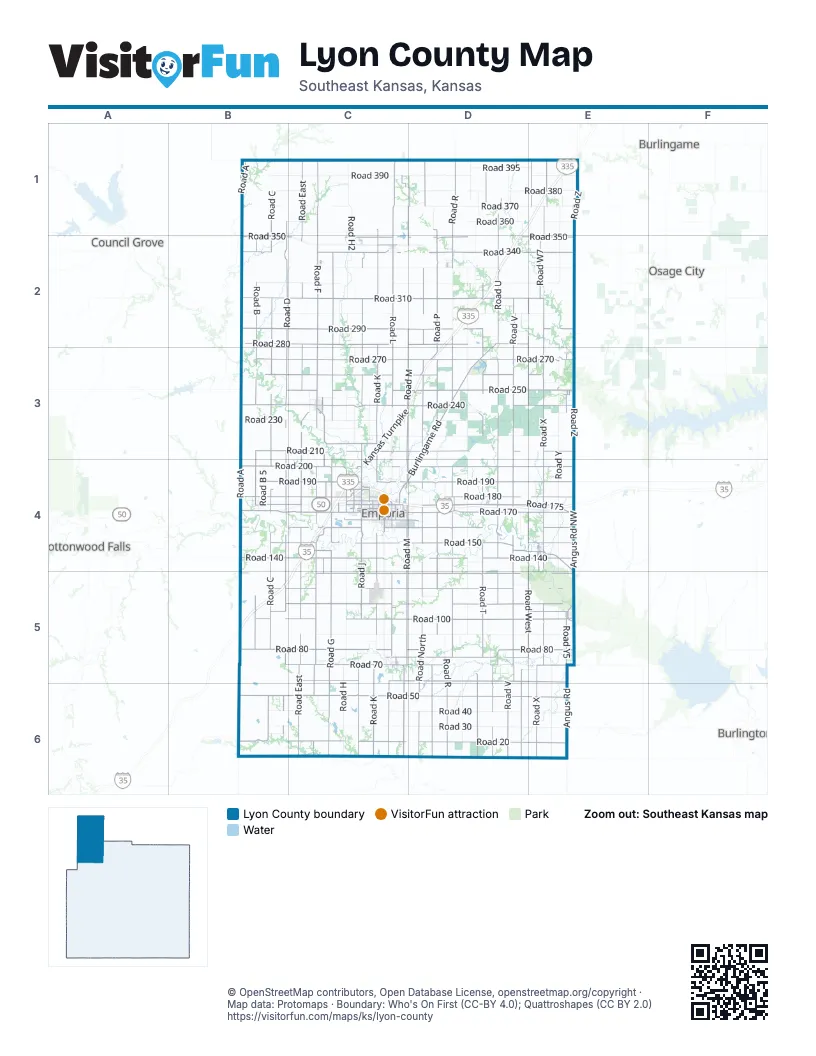
Maps inside Lyon County
2 maps inside, from the street map of Lyon County down.
City
Town
Street index of Lyon County
Each street on the sheet and the grid squares it crosses.
- Kansas TurnpikeD1, E1, D2, C3, D3, C4, B5, C5
- Road 170B4, C4, D4, E4
- Road 340B2, C2, D2, E2
- Road 350B2, C2, D2, E2
- West 6th AvenueC4
- East 6th AvenueC4, D4
- Road 345C2
- West 8th StreetC2
- East 8th StreetC2
- Road XE1, E2, E3, E4, E5, E6
- Road FC1, C2, C3, C4, C5, C6
- Road GC2, C3, C4, C5, C6
- Road MC1, D1, D2, C3, D3, C4, C5, C6
- Road RD1, D2, D3, D4, D5, D6
- Road 200B4, C4, D4, E4
- Road 240B3, C3, D3, E3
- Road 190B4, C4, D4, E4
- Road 250B3, C3, D3, E3
- Burlingame RoadD2, D3, C4, D4
- Road 70B5, C5, D5, E5
- Angus RoadE4, E5, E6
- Road W7E2, E4
- State Highway 130E4, E5
- Road F5C3, C4, C5
- West South AvenueC4, E5
- Prairie StreetC4
- West 12th AvenueC4
- Americus RoadC3
- East StreetD2, C4, E4, C5
- Main StreetC2, D2, E2, C3, E4
- Commercial StreetC4, E4, C5, E5
- Merchant StreetC4
- West 7th AvenueC4
- West 5th AvenueC4
- Industrial RoadC4
- East 12th AvenueC4
- South Commercial StreetC4, E4
- East 7th AvenueC4
- East 5th AvenueC4
- Industrial StreetC4
- North East StreetD2
- Road UD1, D2, D3, D4, D5, D6
- Road EastC1, C2, C3, C4, C5, C6
- Road VD1, D2, D3, D4, D5, D6
- Road NorthD1, D2, D3, D4, D5, D6
- Road LC1, C2, C3, C5, C6
- Road CB1, B2, B3, B4, B5, B6
- Road PD1, D2, D3, D4, D5, D6
- Road DB1, B2, B3, B4, B5, B6
- Road KC1, C2, C3, C4, C5, C6
- Road TD1, D2, D3, D4, D5, D6
- Road WestE1, E2, E3, E4, D5, E5, D6
- Road 50B6, C6, D6, E6
- Road JC2, C3, C4, C5, C6
- Road 270B3, C3, D3, E3
- Road 310B2, C2, D2, E2
- Road 20B6, C6, D6, E6
- Road 100B5, C5, D5, E5
- Road 140B4, C4, D4, E4
- Road AB1, B2, B3, B4, B5
- Road 290B2, C2, D2, E2
- Road 150B4, C4, D4, E4
- Road 60C5, D5, E5
- Road 280B2, C2, D2, E2
- Road BB2, B3, B4, B5
- Road 80B5, C5, D5, E5
- Road 130B5, C5, D5, E5
- Road 110B5, C5, D5, E5
- Road 180B4, C4, D4, E4
- Road 210B3, C3, D3, E3
- Road 260B3, C3, D3, E3
- Road 175B4, C4, D4, E4
- Road ZE1, E2, E3, E4
- Road 160B4, C4, D4, E4
- Road 120B5, C5, D5, E5
- Road 75C5, D5, E5
- Road 400B1, C1, D1, E1
- Road Y5E3, E5
- Road 215C3
- Road 145C4, D4, E4
- Road 105B5, E5
- Graphic Arts RoadC4
- East South AvenueC4, D4, E5
- West 15th AvenueC4
- West 18th AvenueC4
- East Logan AvenueC4, D4
- West 30th AvenueC4
- West 9th AvenueC4
- Exchange StreetC4, E4
- West 24th AvenueC4
- Lincoln StreetC4
- 2nd StreetC2, E2, C3, E3, E4
- County Road 120D5
- Rural StreetC4
- State StreetC4
- Mechanic StreetC4, E5
- South Weaver StreetC4
- Locust StreetC3
- Chestnut StreetE3, C4
- Peyton StreetC4
- Weaver StreetC4
- Road R1D4
- South Prairie StreetC4
- Whildin StreetC4
- West 4th AvenueC4
- Overlander StreetC4
- South StreetC3, E4
- Coronado AvenueC4
- Iowa StreetC5
- Road P 5D5
- South East StreetC4
- East 4th AvenueC4
- West Maple AvenueE5
- South Main StreetC2, E4
- West 18th StreetC4
- 16th RoadE5
- West Santa Fe StreetC5
- North Main StreetC2, E4
- Franklin StreetE3
- County Road 75C5
- 12th RoadE6
- East Santa Fe StreetC5
- Lake RoadC5
- 22nd Road NorthwestE5
- Camp Creek RoadB6
- Road YE1, E2, E3, E4, E5, E6
- Road SouthD1, D2, D3, D4, D5, D6
- Road HC1, C2, C3, C4, C5, C6
- Road 30B6, C6, D6, E6
- Road 90C5, D5, E5
- Road 390B1, C1, D1, E1
- Road 320B2, C2, D2, E2
- Road 370B1, C1, D1, E1
- Road 40B6, C6, D6, E6
- Road 330C2, D2, E2
- Road 220C3, D3, E3
- Road 300B2, C2, D2, E2
- Road 380B1, C1, D1, E1
- Road 230B3, C3, D3
- Road 360B1, C1, D1, E1
- Angus Road NorthwestE4, E5
- Road H2C1, C2
- Road S5D1, D2
- Road H5C2, C3
- Road 395D1, E1
- Road J5C3, C5
- Road 225C3
- Road G5C2
- County Road 101C6
- Road B 5B4
- Walnut StreetE2, C3, E3, C4, E4
- Road 147B4, E4
- 1st StreetC2, E2, C3, E3, E4
- Road 205D3, D4
- Road U5D1
- Road T5D3, D4, D5
- East 18th AvenueC4, D4
- Road E5C3, C4
- Road 155B4, C4, D4
- Neosho StreetC4, E4, E5
- Road X5E5
- Road 137C4, D4
- West StreetC4, E5
- South Carlson RoadE2, E3
- Road 245C3
- Market StreetD2, C4
- Road R5D5
- Road P5D2, D4
- Road N7D1
- Road V5D4
- County Road 102D6, E6
- Road L5C3, C4
- Road 135C4
- Road PsD5
- Congress StreetC4, E5
- 4th StreetC2, E2, C3, E4
- Road V6D1, D2, D4
- 3rd StreetC2, E2, C3, E3, E4
- 5th StreetE2, C3, E4
- Township Road 56C6
- Road 235D3, E3
- 6th StreetC3, E4
- Sylvan StreetC4
- Elm StreetC2, C3, C4
- Road R7D2, D3
- East 9th AvenueC4
- Oak StreetC2, C3, C4
- Road 167D4
- Cottonwood StreetC4
- Road V2D1
- Road S7D1
- Road North 5D4
- 10th StreetC3
- Road 285D2
- Road J7C3
- County Road SouthD5
- Road K 5C5
- Road 25B6
- Constitution StreetC4
- Road 255E3
- Union StreetC4
- Road F2C6
- Road 122D5, E5
- Sunnyslope StreetC4
- Road 67D5, E5
- Road G 5C4
- West 8th AvenueC4
- East 10th AvenueC4
- 7th StreetC3, E4
- South Exchange StreetC4, E4
- Garfield StreetC4
- Road 115D5
- Road 385C1
- Whittier StreetC4
- Orange StreetC3
- Road 305D2
- Mulberry StreetC3, E4
- Freight RoadC4
- Morningside DriveC4
- Luther StreetC4
- Woodland StreetC4
- Lawrence StreetC4
- West Copley AvenueC4
- Graham StreetC4
- Penny LaneC4, D4
- Road 371D1
- Thompson StreetC4
- Road B2B4
- Broad StreetE3, E5
- Road K5C5
- Maple StreetC3, E3
- Morse RoadC4, D4
- East 11th AvenueC4
- Road L2C5
- Road R 5D5
- Sycamore StreetC3
- Road 162C4
- Jones DriveC4
- Bodock RoadD4
- Homewood StreetC4
- Center StreetC4, C5
- East 1st AvenueC4
- Arundel StreetC4
- Kansas StreetC5
- Warren WayC4
- Lakeshore DriveD4
- Broadway StreetC3
- West 11th AvenueC4
- Road V8D4, E4
- West 13th AvenueC4
- P2 RoadD4
- Road B1B4
- Cherry StreetC3
- East 7th StreetC2, D2
- East 6th StreetC2, D2
- Hackberry StreetC3
- East 3rd StreetC2, D2
- Locust LaneD4
- Wilson StreetC4
- Road M1C3, D3
- Wanamaka RoadD4
- West 2nd AvenueC4
- Grand StreetC4
- East Kansas AvenueC4
- North StreetC3, E4
- South Congress StreetC4
- West Randolph AvenueC4
- East Potwin AvenueC4
- South Cottonwood StreetC4
- South Market StreetC4
- South Union StreetC4
- West 1st AvenueC4
- Lakeview StreetC4
- South Mechanic StreetC4
- Road 95E5
- East 2nd AvenueC4
- West 10th AvenueC4
- Washington StreetC4
- East 8th AvenueC4
- Road M5D4
- Sherman StreetC4
- Road 123D5
- Merchants StreetE5
- Road D2C4
- College StreetE5
- South Merchant StreetC4
- Carter StreetC4
- Road 85C5
- Ivy StreetD2
- Huntington RoadC4
- Road V1D2
- Pine StreetC3
- Road 275D3
- Watson StreetC4
- Highland StreetC4
- Grove AvenueC4
- West Exchange AvenueE5
- West Ridge DriveC4
- Road F9C4
- West 1st StreetC2
Things to do on the Lyon County map
Places on the map
- Admire
- Admire-Allen City Lake
- Allen
- Americus
- BNSF Emporia Yard
- Bushong
- Campus Woods
- Champions Landing
- College of Emporia Park
- David Traylor Zoo
- DeBauge Family Sports Complex
- Dryer Park
- East Lake
- Emporia
- Emporia City Library
- Emporia Golf Course
- Emporia High School
- Emporia Middle School
- Emporia Municipal Airport
- Emporia Post Office
- Emporia RV Park
- Emporia Service Area
- Emporia State Univeristy
- ESU Trail
- Flint Hills Mall
- Hartford
- Jones Aquatic Center
- Jones Park
- Lyon County Fairgrounds
- Lyon State Fishing Lake
- Lyon State Fishing Lake and Wildlife Area
- Maplewood Cemetery
- Neosho Rapids
- Olpe
- Olpe City Lake
- Peter Pan Park
- Reading
- Reading Woods Natural Area
- Soden's Grove Park
- Trusler Sports Complex
Next to Lyon County
- Burlingame
- Burlington
- Cottonwood Falls
- Council Grove
- Osage City
- Strong City
© OpenStreetMap contributors, Open Database License, openstreetmap.org/copyright · Map data: Protomaps · Boundary: Who's On First (CC-BY 4.0); Quattroshapes (CC BY 2.0)















