

Kansas road map
I-35 in Kansas map
I-35 is about 232 miles in Kansas. It has 64 exits, from Exit 4 at mile 4 to Exit 235 at mile 232. It meets 28 highways; US 50, US 166 and US 160 meet it in the most grid squares.
Open the map (PDF, US Letter)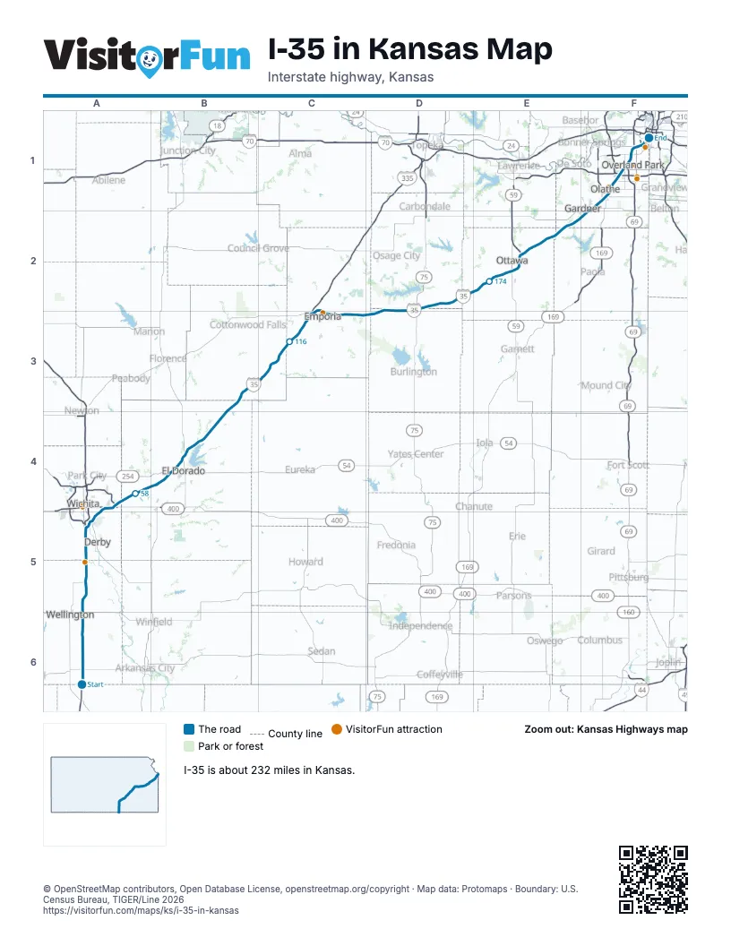
Exits on I-35 in Kansas
Each exit in mile order, with its grid square.
- Exit 4mile 4, A6
- Exit 19mile 19, A6
- Exit 33mile 33, A5
- Exit 39mile 39, A5
- Exit 42mile 41, A5
- Exit 45mile 44, A5
- Exit 50mile 49, A4
- Exit 53Amile 52, A4
- Exit 53mile 52, A4
- Exit 53Bmile 52, A4
- Exit 57mile 57, A4
- Exit 71mile 70, B4
- Exit 76mile 75, B4
- Exit 92mile 92, B3
- Exit 127Amile 126, C3
- Exit 128mile 127, C2
- Exit 130mile 128, C2
- Exit 131mile 129, C3
- Exit 133mile 131, C3
- Exit 135mile 133, C3
- Exit 138mile 136, C3
- Exit 141mile 139, C3
- Exit 148mile 146, D2
- Exit 155mile 154, D2
- Exit 160mile 159, D2
- Exit 162mile 161, D2
- Exit 170mile 168, D2
- Exit 176mile 174, E2
- Exit 182mile 180, E2
- Exit 183mile 180, E2
- Exit 185mile 183, E2
- Exit 187mile 185, E2
- Exit 188mile 186, E2
- Exit 193mile 191, E2
- Exit 198mile 196, E2
- Exit 202mile 200, E2
- Exit 205mile 202, E2
- Exit 207mile 205, F2
- Exit 210mile 208, F1
- Exit 214mile 211, F1
- Exit 215mile 212, F1
- Exit 217mile 214, F1
- Exit 218mile 215, F1
- Exit 220mile 217, F1
- Exit 222Amile 219, F1
- Exit 222Bmile 220, F1
- Exit 224mile 221, F1
- Exit 225mile 222, F1
- Exit 225Amile 223, F1
- Exit 225Bmile 223, F1
- Exit 227mile 224, F1
- Exit 228Amile 225, F1
- Exit 228Bmile 226, F1
- Exit 229mile 226, F1
- Exit 230mile 227, F1
- Exit 231Amile 228, F1
- Exit 1Amile 228, F1
- Exit 231Bmile 228, F1
- Exit 232Amile 229, F1
- Exit 232Bmile 229, F1
- Exit 233Amile 230, F1
- Exit 233mile 231, F1
- Exit 234mile 232, F1
- Exit 235mile 232, F1
Highways I-35 meets
Each highway it meets and the grid squares where they meet.
- US 166A6
- US 160A6
- KS 55A5
- KS 53A5
- KS 15A5
- US 54A4
- US 400A4
- KS 96A4
- KS 254B4
- US 77B4
- KS 177B4
- US 50C3, D2, E2
- KS 57C3
- KS 99C2
- KS 130C3
- US 75D2
- KS 31D2
- KS 273D2
- US 59E2
- KS 68E2
- KS 33E2
- US 56F1
- US 169F1
- KS 7F1
- I-435F1
- US 69F1
- I-635F1
- KS 58F1
Towns along I-35 in Kansas
In mile order, with the grid square of each.
- Mulvanemile 33, A5
- Haysvillemile 39, A5
- Wichitamile 40, A5
- Oaklawn-Sunviewmile 42, A5
- McConnell AFBmile 45, A5
- Andovermile 53, A4
- El Doradomile 70, B4
- Emporiamile 124, C3
- Lebomile 145, D2
- Williamsburgmile 168, D2
- Ottawamile 180, E2
- Wellsvillemile 195, E2
- Edgertonmile 199, E2
- Gardnermile 204, F2
- Olathemile 209, F1
- Lenexamile 217, F1
- Overland Parkmile 219, F1
- Shawneemile 223, F1
- Merriammile 224, F1
- Missionmile 227, F1
- Kansas Citymile 227, F1
- Roeland Parkmile 229, F1
Things to do on the I-35 in Kansas map
© OpenStreetMap contributors, Open Database License, openstreetmap.org/copyright · Map data: Protomaps · Boundary: U.S. Census Bureau, TIGER/Line 2026















