

Kansas map
Lawrence map
About 97,271 people live here (Census Bureau, 2024 estimate). The sheet's index lists 300 streets; South Lawrence Trafficway, West 6th Street and Clinton Parkway cross the most grid squares. Things to do inside the boundary: Allen Fieldhouse, Elizabeth M. Watkins Community Museum and Spencer Museum of Art.
Open the map (PDF, US Letter)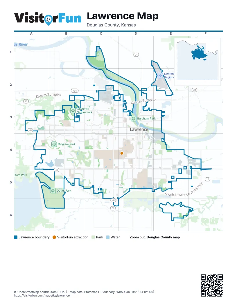
Street index of Lawrence
Each street on the sheet and the grid squares it crosses.
- Kansas TurnpikeC2, D2, E2
- KTA Entrance RoadD2, E2
- West 6th StreetA3, B3, C3, D3
- Clinton ParkwayA4, B4, C4, D4
- East 23rd StreetD4, E4, F4
- Iowa StreetD3, D4, D5
- South Lawrence TrafficwayA3, A4, B4, B5, D5
- Massachusetts StreetD3, D4
- Vermont StreetD3, D4, D5
- West 23rd StreetD4
- North 3rd StreetD2, D3
- McDonald DriveD2, C3, D3
- North 2nd StreetD2, D3
- North 1400 RoadA4
- Kasold DriveC3, C4, C5
- Bob Billings ParkwayA4, B4, C4, D4
- Wakarusa DriveB3, B4
- Louisiana StreetD3, D4, D5
- Haskell AvenueE3, E4, E5
- West 31st StreetC5, D5
- West 9th StreetC3, D3
- Tennessee StreetD3, D4
- Kentucky StreetD3, D4
- East 15th StreetD4, E4
- East 19th StreetD4, E4
- East 31st StreetE5
- Peterson RoadB2, C2, D2
- West 19th StreetC4, D4
- North Kasold DriveC2, C3
- North Iowa StreetD2, D3
- Queens RoadB2, B3
- East 11th StreetD3, E3
- Lakeview RoadC2, D2
- North 1800 RoadD1, C2, D2
- West 11th StreetD3
- Noria RoadF4
- North 1300 RoadE5
- East 1200 RoadC1, C2
- East 1750 RoadF4
- Lawrence AvenueC2, C3, C4, C5
- Harvard RoadA3, B3, C3, D3
- West 27th StreetB5, C5, D5
- Inverness DriveB3, B4, B5
- Alabama StreetD3, D4, D5
- Crestline DriveC3, C4, C5
- Naismith DriveD4
- Princeton BoulevardC2, C3, D3
- Overland DriveA3, B3, C3
- George Williams WayA3, A4
- Harper StreetE4, E5
- Trail RoadB3, C3
- New Hampshire StreetD3, D4
- Monterey WayC2, C3, C4
- West 7th StreetB3, C3, D3
- O'Connell RoadE4, E5, E6
- Crossgate DriveB4, C4, C5
- Michigan StreetD2, D3, D5
- East 25th TerraceE5, F5
- Barker AvenueD4, D5
- West 8th StreetB3, C3, D3
- Maine StreetD3, D4
- Maple StreetD3, E3
- Folks RoadB2, B3
- East 900 RoadA3, A4, A5
- Locust StreetD3, E3
- Lyon StreetD2, E2
- Connecticut StreetD3, D4
- Rock Chalk DriveA3, B3
- West 4th StreetD3
- Greenway CircleF4
- North Michigan StreetD2
- Venture Park DriveE4, F4
- Stoneridge DriveA3, B3
- North 7th StreetE1, E2, E3
- East 27th StreetE5
- West 2nd StreetD3
- North Monterey WayC2
- North StreetD2, E2
- Kensington RoadE5
- West 15th StreetD4
- East 28th StreetE5
- Riverridge RoadD2
- Grand Vista DriveC2
- North 1500 RoadA4
- East 9th StreetD3, E3
- North 1700 RoadB2
- West 35th StreetD5, D6
- North 1200 RoadB6
- East 1600 RoadE2
- Branchwood DriveB3
- East 7th StreetD3, E3
- West Campus RoadD3, D4
- Fambrough DriveD3
- Franklin RoadF4, F5
- East 6th StreetD3
- North 1550 RoadE3
- Mulberry DriveB3
- Ohio StreetD3, D4, D5
- Ousdahl RoadD4, D5
- Mississippi StreetD3, D4
- West 18th StreetB4, D4
- Rhode Island StreetD3, D4
- Missouri StreetD3, D4, D5
- Indiana StreetD3, D4
- Delaware StreetE3, E4
- West 24th StreetB4, C4, D4, B5
- West 22nd StreetC4, D4
- Atchison AvenueC4, C5
- Arkansas StreetD3, D4, D5
- Clinton Parkway FrontageB4, C4
- West 25th StreetB5, C5, D5
- Illinois StreetD3, D4
- East 902 RoadA2, A5, A6, B6
- West 21st StreetC4, D4
- West 26th StreetB5, C5, D5
- West 5th StreetD3
- Elm StreetD3, E3
- West 27th TerraceB5, C5, D5
- University DriveC3, C4, D4
- Pennsylvania StreetE3, E4
- East 13th StreetD4, E4
- West 10th StreetC3, D3
- Lincoln StreetD3, E3
- New York StreetE3, E4
- Stonecreek DriveA3, B3
- Learnard AvenueE4
- West 12th StreetB3, C3, D3
- West 29th TerraceC5, D5
- New Jersey StreetE3, E4
- West 13th StreetC3, B4, C4, D4
- Engel RoadD4
- Research Park DriveB3, B4
- Walnut StreetE3
- West 33rd StreetC5, D5
- Irving Hill RoadC4, D4
- Wagon Wheel RoadB3, C3, B4
- Oxford RoadC3, D3, C4
- Stratford RoadC3, D3, C4
- Eisenhower DriveB2, B3
- Eldridge StreetB3
- Maple LaneE4
- Lake Alvamar DriveA4
- Westdale RoadC3
- Wimbledon DriveB4
- West 14th StreetB4, C4, D4
- North 8th StreetE2, E3
- East 8th StreetD3, E3
- East 12th StreetD3, E3
- Tomahawk DriveC2, C3
- West 22nd TerraceC4, D4
- Rockledge RoadC3
- West 24th PlaceB4, C4
- Ridge CourtD4, D5
- West 28th StreetC5, D5
- East 24th StreetE4
- Schwarz RoadC3
- Yale RoadC3, D3
- East 26th StreetE5, F5
- Alvamar DriveC4
- Legends DriveB3, B4
- West 20th StreetD4
- North 5th StreetE2, E3
- North 4th StreetE2, E3
- West 30th StreetC5, D5
- Riverview RoadC3
- West 3rd StreetD3
- Becker DriveC4, D4
- East 17th StreetD4, E4
- Speicher RoadB4, B5
- East 25th StreetE4, F5
- Carmel DriveB4
- Petefish DriveC4
- Florida StreetD2, D3
- Sunset DriveD3
- Iowa Street FrontageC5, D5
- Renaissance DriveA3
- Wisconsin StreetD3
- Quail Creek DriveC4
- Jayhawk BoulevardD4
- East 29th StreetE5
- East 14th StreetD4, E4
- West 17th StreetD4
- Ponderosa DriveE4, E5
- Perry StreetD3, E3
- Stone Meadows DriveB3, B4
- Foxfire DriveB4
- Turnberry DriveB4
- Arrowhead DriveC2
- East 26th TerraceE5, F5
- Constant AvenueC4
- Rock Fence PlaceC3
- Randall RoadC3, C4
- Brook StreetE3, E4
- North 6th StreetE2, E3
- Nicklaus DriveB4
- Running Ridge RoadC2, C3
- Bauer Farm DriveB3
- Bobwhite DriveA4
- Winterbrook DriveC5
- Heatherwood DriveC4
- Belle Haven DriveD5
- Greenway DriveF4
- Fall Creek RoadC2, C3
- Westbrooke StreetC4
- Emery RoadD3, D4
- Prescott DriveB3
- Brush Creek DriveC4, C5
- Maverick LaneE5
- Wellington RoadC3
- Memorial DriveD4
- Sunnyside AvenueD4
- April Rain RoadA3
- West 19th TerraceD4
- Yellowstone DriveC4, C5
- Congressional DriveB3
- Highland DriveD3
- Lake StreetE2
- Mercato DriveA3
- East 21st TerraceE4
- East 1000 RoadB5, B6
- East Perimeter RoadE4, E5
- Hutton CircleC2
- Rawhide LaneE5
- West 29th StreetC5, D5
- Bonanza StreetE5
- North 9th Street - East 1550 RoadE3
- Four Wheel DriveC5
- Jana DriveC3
- Minnesota StreetD2, D3
- East 21st StreetD4, E4
- Stetson DriveB3, C3
- West 28th TerraceC5, D5
- Kanza DriveA3, A4, B4
- East 10th StreetD3, E3
- Orchard LaneC3, D3
- Melholland RoadC4
- Dole DriveB2, B3
- East 16th StreetD4, E4
- Avalon RoadD3
- Indian AvenueD4, E4
- West 21st TerraceD4
- Miller DriveE4
- Arizona StreetC3
- Daylily DriveC2
- Blazing Star DriveC2
- East 22nd StreetD4, E4
- Goldfield StreetB3
- Marvonne RoadC4
- Crescent RoadD4
- West Perimeter RoadD4, D5
- Saint Andrew's DriveC4
- West 24th TerraceC4, C5
- Lazy Brook LaneC5
- Oak Tree DriveB3
- Lankford DriveE5
- Kasold Drive FrontageC4
- Redbud LaneD5
- Vantuyl DriveB3, B4
- Tillerman DriveC2
- Longleaf DriveA3, A4
- Oregon StreetE3, E4, E5
- Frontier RoadC3
- Blackjack Oak DriveB5
- East 23rd Street FrontageE4
- Prestwick DriveB4
- Brett DriveC2
- East 18th StreetD4, E4
- Earhart CircleB2, B3
- East 1100 RoadB2
- Airport RoadE1, E2
- El Dorado DriveC4
- Jasu DriveD4, D5
- Biltmore DriveB3
- East 30th StreetE5
- Morning Dove CircleC2
- Saddlehorn DriveB3, C3
- Waverly DriveB3, B4
- North Crestline DriveC2
- Rock Chalk LaneA2, A3
- Cedarwood AvenueD4, D5
- Bluestem DriveB5
- Longhorn DriveC3
- Legend Trail DriveA4
- Boulder StreetC3
- Bently DriveC2
- Centennial DriveC3
- Hilltop DriveD3
- Sharon DriveB2, B3
- Bishop StreetE5
- Silver Rain RoadA3
- North 1900 RoadE1
- Ranger DriveC2, C3
- Holiday DriveC3
- Prairie AvenueE3, E4
- Woodland DriveB3
- Parker CircleB2
- Brentwood DriveC2
- Diamondhead DriveA3
- North 1950 RoadE1
- Stowe DriveC2
Things to do on the Lawrence map
Places on the map
- Allen Fieldhouse
- BNSF Lawrence Yard
- Brook Creek Park
- Burcham Park
- Burroughs Creek Trail and Linear Park
- Clinton Lake Softball Complex
- DeVictor Park
- Douglas County Fairgrounds
- Douglas County Jail
- Downtown Lawrence
- Eagle Bend Golf Course
- Free State High School
- Haskell Rail-Trail
- Haskell Wetlands
- Hidden Valley Camp
- Lake Alvamar
- Lawrence Country Club
- Lawrence KOA Holiday
- Lawrence Memorial Hospital
- Lawrence Nature Park
- Lawrence Regional Airport
- LMH Health West Campus
- Martin Park
- Marvin Grove
- Mutt Run
- Naismith Valley Park
- Oak Hill Cemetery
- Outlet Park
- Pennys Concrete, Inc. Sand
- Peterson Park
- Pine Ridge Plaza
- Prairie Park
- Riverfront Park
- Rock Chalk Park
- Sesquicentennial Point
- Sports Pavilion Lawrence
- Stonegate Park
- The Jayhawk Club
- University of Kansas
- Youth Sports Complex
© OpenStreetMap contributors, Open Database License, openstreetmap.org/copyright · Map data: Protomaps · Boundary: Who's On First (CC-BY 4.0); U.S. Census Bureau