

Kansas map
Northeast Kansas map
The sheet's index lists 21 highways; US 75, I-35 and US 36 cross the most grid squares. Things to do inside the boundary: Allen Fieldhouse, Amelia Earhart Hangar Museum and Brown v. Board of Education National Historical Park. Also on it: Atchison, Basehor and Bonner Springs.
Open the map (PDF, US Letter)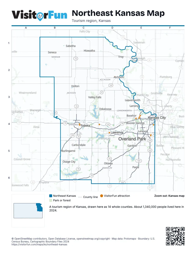
Highway index of Northeast Kansas
Each highway on the sheet and the grid squares it crosses.
- I-35C6, D5, D6, E4, E5
- I-70B4, C4, D4, E4
- I-335B5, C4, C5
- I-435E4
- I-470C4
- I-635E4
- I-670E4
- US 24B4, C4, D4, E4
- US 36B1, C1, D1, D2, E2
- US 40B4, C4, D4, E4
- US 50C6, D5, D6, E4, E5
- US 56E4, E5
- US 59D2, D3, D4, D5, D6
- US 69E4, E5, E6
- US 73D2, D3, E3, E4
- US 75C1, C2, C3, C4, C5, C6
- US 169D6, E4, E5, E6
- KS 4C3, C4
- KS 5E4
- KS 16C3
- KS 31C5, C6
Things to do on the Northeast Kansas map
- Allen Fieldhouse
- Amelia Earhart Hangar Museum
- Brown v. Board of Education National Historical Park
- Combat Air Museum
- Comfort Suites Speedway - Kansas City
- Dave & Buster's Kansas City
- Drury Inn & Suites Kansas City Overland Park
- Elizabeth M. Watkins Community Museum
- Hyatt Place Kansas City/Overland Park/Metcalf
- Kansas City Renaissance Festival
- Kansas Historical Society
- Kansas Speedway
- Kansas State Capitol
- Mahaffie Stagecoach Stop & Farm
- Old Prairie Town at Ward-Meade Historic Site
- Rosedale World War I Memorial Arch
- Spencer Museum of Art
- Territorial Capital Museum
- University of Kansas Natural History Museum
- West Ridge Mall
Places on the map
- Atchison
- Basehor
- Bonner Springs
- Burlingame
- Carbondale
- Gardner
- Hiawatha
- Holton
- Kansas City
- Lansing
- Lawrence
- Leavenworth
- Lenexa
- Osage City
- Oskaloosa
- Ottawa
- Overland Park
- Paola
- Sabetha
- Seneca
- Topeka
- Troy
- Valley Falls
Next to Northeast Kansas
- North Central Kansas map
- Southeast Kansas map
- Northwest Missouri
- Southwest Missouri
- Southeast Nebraska
© OpenStreetMap contributors, Open Database License, openstreetmap.org/copyright · Map data: Protomaps · Boundary: U.S. Census Bureau, Cartographic Boundary Files 2024