

Kansas map
Liberal Township map
About 19,184 people live here (Census Bureau, 2024 estimate). The sheet's index lists 87 streets; County Road G, County Road C and County Road B cross the most grid squares. Also on it: Keating Tractor & Equipment, Liberal Memorial Cemetery and CPTC426 Hold Signal.
Open the map (PDF, US Letter)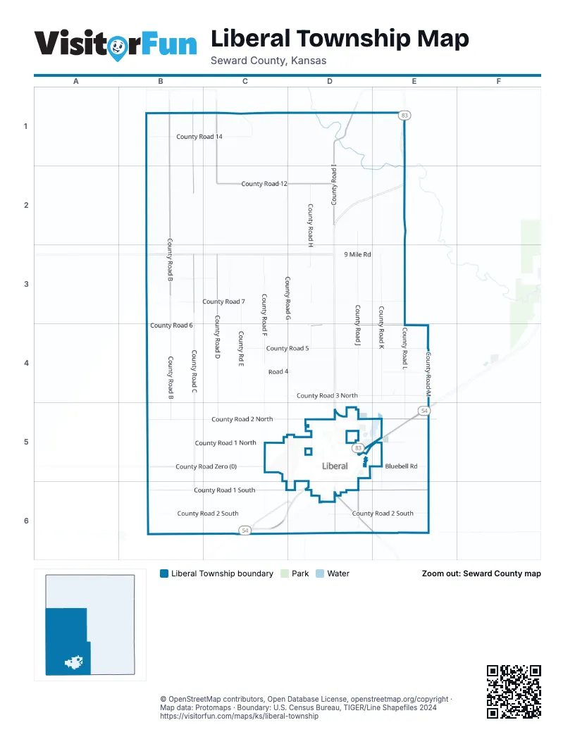
Street index of Liberal Township
Each street on the sheet and the grid squares it crosses.
- County Road 14B1, C1
- County Road 15B1
- County Road BB1, B2, B3, B4, B5
- County Road CB1, B2, B3, B4, B5, B6
- Road TB1
- County Road DC1, C2, C3, C4, C5
- County Road EastC1, C3, C4, C5
- County Road GC1, C2, D2, D3, D4, D5, D6
- County Road ID1, D2, D6
- Satanta Cut Off RoadD1
- County Road 13E1
- Road PB2
- Road RB2
- County Road 12C2, D2
- 12 Mile RoadD2
- County Road HD2, D3, D4, D5
- County Road JD2, D3, D4, D5, D6
- County Road 7B3, C3, D3
- County Road 8B3, C3
- Road MB3
- County Road FC3, C4, C5, C6
- 7 Mile RoadD3, E3
- 9 Mile RoadD3, E3
- County Road KE3, E4, E5, E6
- County Road LE3, E4, E5
- County Road 5B4, C4, D4, E4
- County Road 6B4, D4, E4
- Road JB4
- County Road 3 NorthC4, D4, E4
- Road 4C4, D4
- 3 Mile RoadD4
- County Road 4E4
- County Road ME4, E5, E6
- Heather Ridge AvenueE4
- Polo WayE4
- County Road 1 NorthB5, C5, E5
- County Road 2 NorthB5, C5, D5, E5
- County Road Zero (0)B5, C5
- Road FC5
- Aster LaneD5
- Bluebell RoadD5, E5
- Carlton AvenueD5
- Centennial BoulevardD5
- East 15th StreetD5
- East 5th StreetD5
- East 8th StreetD5, E5
- Lilac DriveD5
- Long AvenueD5
- North Grant AvenueD5
- North Kansas AvenueD5
- North Western AvenueD5
- Railroad AvenueD5
- Ridge RoadD5
- Rockridge RoadD5
- Sierra DriveD5
- The Yellow Brick RoadD5, E5, C6, D6
- West 10th StreetD5
- West 11th StreetD5
- West 8th StreetD5
- Zinnia LaneD5
- County Road 1 SouthB6, C6, D6, E6
- County Road 2 SouthB6, C6, D6, E6
- Mile 54B6
- E0007 RoadC6, E6
- Hillside DriveC6
- Meadows LaneC6
- Mile 56C6
- Mile 57C6
- Old United States Highway 54C6, D6
- Second Lieutenant Luke James Memorial HighwayC6
- Wildflower CourtC6
- Wildflower LaneC6
- East Birch StreetD6
- Harold BoulevardD6
- Pioneer DriveD6
- South Clay AvenueD6
- South Country Estates RoadD6, E6
- South Grant AvenueD6
- South Kansas AvenueD6
- South New York AvenueD6
- South Pershing AvenueD6
- South Sherman AvenueD6
- South StreetD6
- Sycamore StreetD6
- V F W Second Street RoadD6
- Western AvenueD6
- Oklahoma Panhandle Vietnam Veterans Memorial HighwayE6
Places on the map
- CPTC426 Hold Signal
- CPTC429 East Liberal
- First Assembly of God Church
- Keating Tractor & Equipment
- Liberal Memorial Cemetery
Next to Liberal Township
© OpenStreetMap contributors, Open Database License, openstreetmap.org/copyright · Map data: Protomaps · Boundary: U.S. Census Bureau, TIGER/Line Shapefiles 2024















