

Kansas map
Seward County map
About 21,276 people live here (Census Bureau, 2024 estimate). The sheet's index lists 300 streets; The Yellow Brick Road, County Road J and County Road T cross the most grid squares. Things to do inside the boundary: Liberal.
Open the map (PDF, US Letter)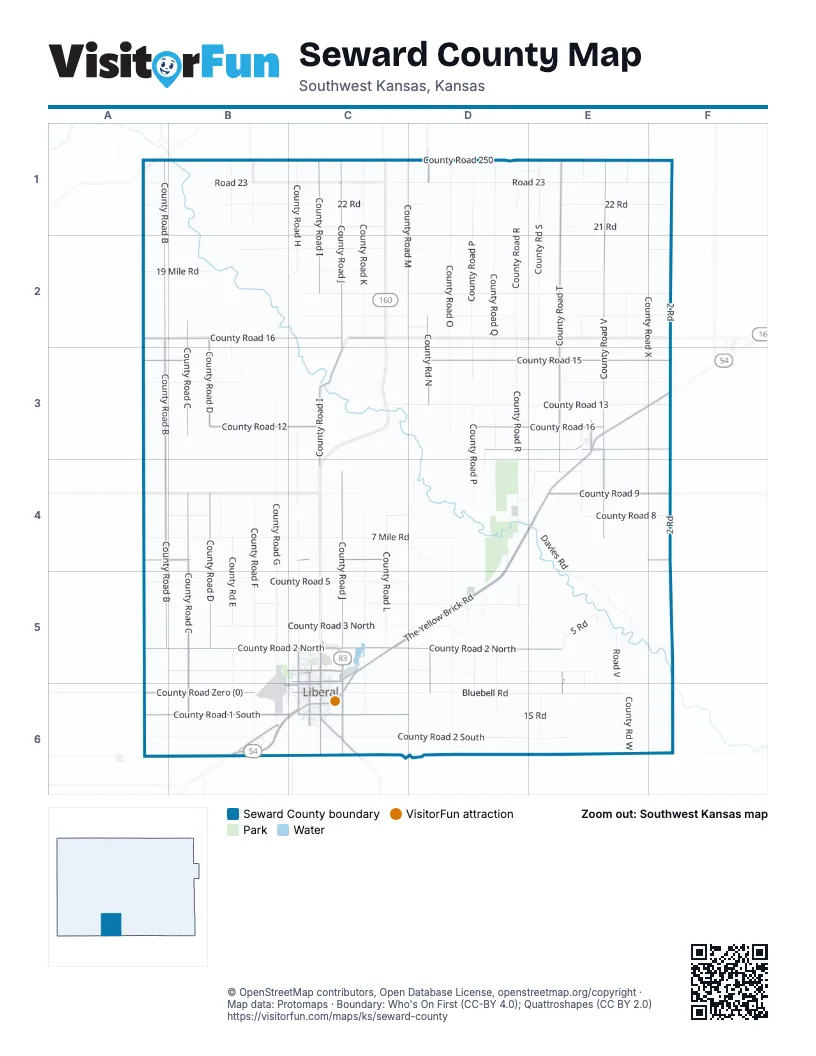
Maps inside Seward County
2 maps inside, from the street map of Seward County down.
City
Town
Street index of Seward County
Each street on the sheet and the grid squares it crosses.
- The Yellow Brick RoadE3, F3, D4, E4, C5, D5, B6, C6
- County Road JC1, C2, C3, C4, C5, C6
- South Country Estates RoadC6
- West Pancake BoulevardC6
- North Country Estates RoadC5, C6
- East Pancake BoulevardC6
- Oklahoma Panhandle Vietnam Veterans Memorial HighwayC6
- Second Lieutenant Luke James Memorial HighwayB6
- North Kansas AvenueC5, C6
- South Kansas AvenueC6
- County Road BA1, A2, A3, A4, A5
- County Road 15A3, B3, D3, E3, F3
- County Road 2 NorthA5, B5, C5, D5, E5
- County Road VE1, E2, E3, E4
- County Road TE1, E2, E3, E4, E5, E6
- County Road CB2, B3, B4, B5, B6
- County Road 16A2, B2, C2, D3, E3
- County Road IC1, C2, C3, C4, C6
- County Road DB2, B3, B4, B5
- County Road 1 SouthA6, B6, C6, D6
- County Road NorthD1, D2, D3, D5, D6
- County Road 6A4, B4, C4, F4
- County Road 9E4, F4
- County Road Zero (0)A6, B6
- County Road 12B3, C3
- Old United States Highway 54B6
- Satanta Cut Off RoadC1, C3
- North Western AvenueC5, C6
- East 8th StreetC5
- 16 Mile RoadC2
- South Clay AvenueC6
- West 15th StreetB5, C5
- West 7th StreetC6
- West 8th StreetC5
- West 2nd StreetC6
- South Western AvenueC6
- East 15th StreetC5
- East Pine StreetC6
- 12 Mile RoadC3
- West Pine StreetC6
- North Clay AvenueC5, C6
- Westhaven DriveC5
- V F W Second Street RoadC6
- Terrace AvenueC5
- John Jacobson DriveC5
- West 7th Street NorthB6, C6
- West 7th Street SouthB6, C6
- County Road OOD1
- County Road OD1, D2, D3, D4, D5, D6
- County Road MC1, C2, C3, D4, D5, D6
- County Road KC1, C2, C3, C4, C5, C6
- County Road XF1, F2, F3, F4
- County Road 2 SouthA6, B6, C6, D6, E6
- County Road PD1, D2, D3, D4, D5, D6
- County Road QD1, D2, D3, D5, D6
- Road 23A1, B1, C1, D1, E1, F1
- 2 RoadF1, F2, F3, F4, F5
- County Road RD1, D2, D3, D4, D5
- 22 RoadB1, C1, D1, E1, F1
- County Road EastB1, B2, B3, B4, B5, B6
- Bluebell RoadC6, D6, E6
- County Road 13C3, D3, E3, F3
- County Road GB3, B4, B5, B6
- County Road FB1, B4, B5, B6
- County Road 5A5, B5, C5, D5
- County Road SouthE1, E2, D4, E4, E6
- County Road 18C2, D2, E2, F2
- County Road HC1, C2, C3, C4, C5
- County Road 1 NorthA5, B5, C5, D5, E5
- County Road 3 NorthB5, C5, D5
- County Road 7A4, B4, C4, E4, F4
- County Road 14A3, B3, E3, F3
- County Road 250A1, B1, C1, D1, E1, F1
- 19 Mile RoadA2, B2, C2
- County Road 4C5, D5, E5
- County Road 8A4, B4, C4, D4, E4, F4
- 21 RoadD1, E1, F1
- County Road 17C2, D2, E2, F2
- County Road WestE1, E2, E6
- 20 Mile RoadB2, C2
- 7 Mile RoadC4, D4
- County Road UE1, E2, E3, E4, E5, E6
- County Road LC4, C5
- 21 Mile RoadC1
- S RoadE5
- 17 Mile RoadC2
- 18 Mile RoadC2
- Davies RoadE4, E5
- County Road AA1, A2
- 17 RoadE2
- Co River RoadE5
- Road VE5, E6
- County Road 10E4
- 9 Mile RoadC4
- County Road 19E2
- County Road 20C2, D2, F2
- South Pershing AvenueC6
- North Calhoun AvenueC5, C6
- General Welch BoulevardB5, B6, C6
- 1S RoadD6, E6
- North Grant AvenueC5, C6
- Road 4B5
- Triple RoadD3, D4
- West 11th StreetC5
- North Roosevelt AvenueC5, C6
- East Cedar StreetC6
- West 4th StreetB6, C6
- South New York AvenueC6
- South Washington AvenueC6
- North Jordan AvenueC5, C6
- West Walnut StreetC6
- North Pershing AvenueC5, C6
- South Calhoun AvenueC6
- North Prospect AvenueC5, C6
- South Cain AvenueC6
- Road FB5, B6
- South Pennsylvania AvenueC6
- West 5th StreetC6
- West 6th StreetC6
- West 10th StreetC5
- West 1st StreetC6
- County Road 3 SouthE6, F6
- 22 Mile RoadA1
- North New York AvenueC5, C6
- G RoadF1
- North Washington AvenueC5, C6
- Stadium AvenueC5, C6
- South Holly DriveC5
- West 3rd StreetB6, C6
- North Webster AvenueC5, C6
- East 2nd StreetC6
- Lilac DriveC5
- North Tulane AvenueC5, C6
- North Cain AvenueC5, C6
- E0007 RoadB6, C6
- South Virginia AvenueC6
- North Carlton AvenueC5
- North Purdue AvenueC5, C6
- Calvert AvenueC5, C6
- North Lincoln AvenueC5, C6
- North Sherman AvenueC5, C6
- East 7th StreetC6
- North Industrial Park AvenueC5, C6
- Sycamore StreetC6
- South Grant AvenueC6
- Panhandle RoadD4, E4
- Terminal AvenueB5, B6
- East 5th StreetC6
- Airpark AvenueB6, C6
- Bennett RoadD5
- Harold BoulevardC6
- South Jordan AvenueC6
- Green Hill RoadD5
- South Roosevelt AvenueC6
- R Park RoadD4
- North Pennsylvania AvenueC5, C6
- J RoadF1
- North Oklahoma AvenueC5, C6
- South Webster AvenueC6
- North Nebraska AvenueC5, C6
- East Oak StreetC6
- South Lincoln AvenueC6
- H RoadF1
- South StreetC6
- West Ohio StreetC6
- County Road WWE1
- Bellaire AvenueC5
- Wildflower LaneB6
- South Parkway BoulevardC5
- South Sherman AvenueC6
- North Missouri AvenueC5, C6
- K RoadF2
- East Spruce StreetC6
- Railroad StreetE3
- West Coolidge StreetC6
- South Seward AvenueC6
- South Oklahoma AvenueC6
- Market StreetE3
- East 10th StreetC5
- East 11th StreetC5
- East 6th StreetC6
- North Holly DriveC5
- Maple BoulevardC6
- Nelson AvenueC5
- Hillside DriveB6
- Truck Driving practice roadC5
- Elm BoulevardC6
- East Hickory StreetC6
- Sierra DriveC5
- East Railroad AvenueC6
- East Walnut StreetC6
- South Ark LaneD5
- North Ark LaneD5
- West Hickory StreetC6
- West Spruce StreetC6
- West Locke StreetC6
- East 9th StreetC5
- Polo WayD5
- West 9th StreetC5
- Telzey LaneD5
- Andrew LaneD5
- North Fairview AvenueC5
- Frontage RoadC5
- Sunflower BoulevardC5
- 5th StreetC6
- Chestnut StreetE3
- Railroad AvenueC5, C6
- Zinnia LaneC5
- Wilson StreetC6
- West Curtis StreetC6
- Hoover StreetC6
- Road MA4
- West Trail StreetC6
- Road QA3
- Delaware AvenueE3
- Edwards AvenueC5
- Sunset AvenueC5
- Cottonwood LaneC5
- 20th StreetC5
- 2nd StreetB6, C6
- Jewell AvenueC6
- Canna LaneC5
- Country Club DriveC5
- Kansas AvenueE3, C6
- North Countryside DriveC5
- Fense LineE4
- Wind Ridge Drive RoadC5
- Mile 56B6
- East 4th StreetC6
- Mile 54A6
- Violet LaneC5
- Palo Verde DriveC6
- Long AvenueC5
- North StreetE3
- Heather Ridge AvenueC5
- Mustang DriveE3, C5
- Starlight DriveC6
- West Railroad StreetC6
- Yale AvenueC6
- Oak StreetC6
- Fairgrounds LaneC5
- Mustang RoadF3
- Charles StreetC6
- Ark AvenueE3
- Maxwell AvenueE3
- Carlton AvenueC5
- Cornell AvenueC6
- Princeton AvenueC6
- East Ark LaneD5
- Centennial BoulevardC5
- East Park StreetC6
- Lincoln AvenueC5
- Rose LaneC5
- Norwood StreetC5
- 9th StreetB5, C5
- Windsor LaneC5
- Ohio StreetC6
- Jerry StreetC6
- Mc Cray BoulevardC6
- Mission BoulevardC6
- Meadows LaneB6
- State StreetC6
- Hancock StreetC6
- East 18th StreetC5
- Harrison CircleC6
- Harder RoadD5
- Apollo StreetC5
- Broadway AvenueE3
- Don StreetE3
- South Prospect AvenueC6
- Linn BoulevardC6
- Tulip LaneC5
- Road UA3
- Locust StreetE3
- Ridge RoadC5
- Curtis StreetC6
- Dahlia LaneC5
- AcademyC6
- South Purdue AvenueC6
- George AvenueC6
- Harvard AvenueC6
- Forrest AvenueC6
- I RoadF1
- East 3rd StreetC6
- East Birch StreetC6
- Krause CourtC5
- Parkway BoulevardC5
- Tamarack LaneC5
- Nevada DriveC5
- Arlington DriveC6
- Mesquite LaneC6
- Cheyenne RoadC5
- Road PA4
- Griffith AvenueC6
- Road TA3
- Poplar StreetC6
- Armory RoadC5, C6
- County Road SSD1
- Madison StreetC6
- Aster LaneC5
Things to do on the Seward County map
Places on the map
- AMERICAN INN OF LIBERAL
- Arkalon Cemetery
- Arkalon Park
- AutoZone
- Banner Cemetery
- Bellaire Park
- Blue Bonnet Park
- Brookdale Liberal Springs
- City Swimming Pool
- Comfort Suites
- Cooper Park
- Coronado Museum
- Cottonwood Intermediate School
- Country Club
- Country Club Acres Park
- Days Inn
- Dillons
- Dorothy's House and Land of Oz
- Eisenhower Middle School
- Fairfield Inn & Suites Liberal
- Keating Tractor & Equipment
- Kismet
- Kismet Post Office
- Kismet Public Library
- Leete Park
- Liberal
- Liberal Cemetery
- Liberal Fire Department Station 3
- Liberal Memorial Cemetery
- Liberal Mid-America Regional Airport
- Light Park
- Love's Travel Stop
- MacArthur Elementary School
- Mahuron Park
- Meadowlark Elementary School
- Memorial Library
- National Beef Family Sports Complex
- SouthWest Medical Center
- Supreme Feeders Airport
- Willow Tree Golf Course
© OpenStreetMap contributors, Open Database License, openstreetmap.org/copyright · Map data: Protomaps · Boundary: Who's On First (CC-BY 4.0); Quattroshapes (CC BY 2.0)















