

Kansas map
Salina map
About 46,109 people live here (Census Bureau, 2024 estimate). The sheet's index lists 300 streets; South 9th Street, South Ohio Street and South Centennial Road cross the most grid squares. Things to do inside the boundary: Kansas I-70, The Garage and Visit Salina.
Open the map (PDF, US Letter)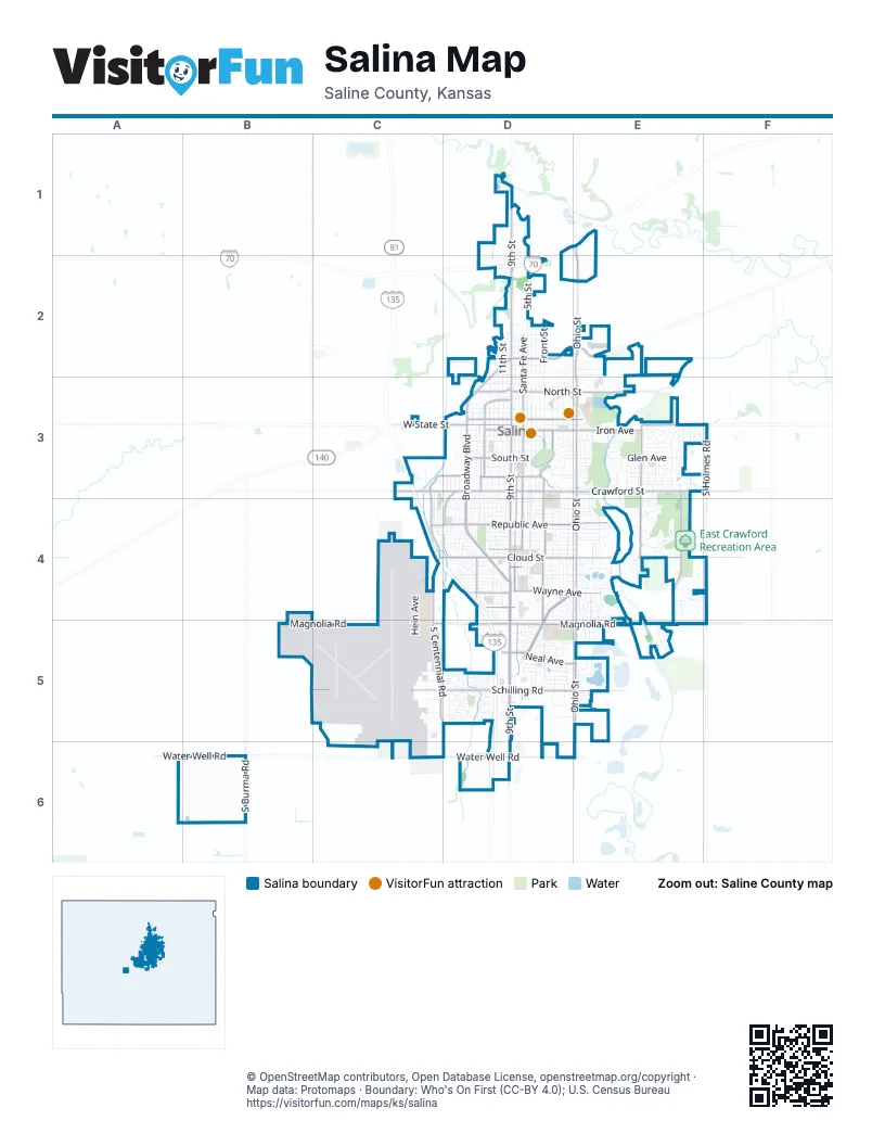
Street index of Salina
Each street on the sheet and the grid squares it crosses.
- Dwight D. Eisenhower HighwayE1, D2
- South 9th StreetD3, D4, D5, D6
- North 9th StreetD1, D2, D3
- East Magnolia RoadD5, E5, F5
- West Magnolia RoadC5, D5
- South Ohio StreetE3, E4, E5, E6
- South Broadway BoulevardD3, D4
- East Crawford StreetD3, E3, F3
- South Centennial RoadC3, C4, C5, D5
- Belmont BoulevardD4, E4, D5
- North Ohio StreetE1, E2, E3
- West Water Well RoadB6, C6, D6
- East Cloud StreetD4, E4, F4
- West Schilling RoadB5, C5, D5
- West Crawford StreetC3, D3
- South Santa Fe AvenueD3, D4
- East Schilling RoadD5, E5
- North Santa Fe AvenueD2, D3
- West State StreetC3, D3
- North Broadway BoulevardD2, D3
- West Cloud StreetC4, D4
- East Pacific AvenueD2, E2
- East Ash StreetD3, E3
- West Ash StreetD3
- West Claflin AvenueD4
- West Pacific AvenueD2
- North Old Highway 81D1
- South Holmes RoadF3, F4
- Highland AvenueD3, D4, D5
- Markley RoadE3, E4, E5
- East Iron AvenueD3, E3
- East North StreetD3, E3
- Quincy StreetD4, D5
- West Republic AvenueC4, D4
- East Republic AvenueD4, E4
- South Marymount RoadE3, E4
- East Wayne AvenueD4, E4
- East Water Well RoadD6, E6
- South Burma RoadB6
- South Front StreetD3, D4
- Marymount RoadE3
- Cherokee DriveD3, D4
- East Neal AvenueD5, E5
- West South StreetD3
- West North StreetD3
- Country Club RoadE3
- South College AvenueD3
- Beverly DriveC3, D3
- West Prescott AvenueD3
- Otto AvenueD4
- Haskett AvenueD4
- West Iron AvenueD3
- Montrose StreetD3
- Saturn AvenueD4
- Bishop StreetD3
- North College AvenueD3
- Prescott RoadD3, E3
- South Oakdale AvenueD3
- North Kenwood Park DriveD3
- East Prescott AvenueD3
- Kenwood Park DriveD3
- Charlotte AvenueD4
- North Marymount RoadE3
- Allen StreetD5
- South Oakdale DriveD3
- West Wayne AvenueD4
- South 4th StreetD3, D4
- North 5th StreetD1, D2, D3
- Scanlan AvenueC4, C5, C6
- Roach StreetD3, D4, E4
- Lewis AvenueD3, D4, E4
- South 11th StreetD3, D4
- North Front StreetD2, D3
- South 10th StreetD3, D4
- South 5th StreetD3, D4
- Fairdale RoadE3, E4
- Edward StreetD4, D5
- North 7th StreetD2, D3
- North 12th StreetD2, D3
- East Beloit AvenueD4, E4
- North 11th StreetD2, D3
- East Ellsworth AvenueD4, E4
- Planet AvenueD4, D5
- Scott AvenueC4, D4, D5, E5
- North 8th StreetD2, D3
- Glen AvenueE3
- East Minneapolis AvenueD4, E4
- West Farrelly RoadB6
- Gypsum AvenueD3, E3
- North 13th StreetD2, D3
- Ray AvenueD5
- Red Fox LaneE4
- Huntington RoadE4, E5
- Norton StreetD4
- South 12th StreetD3
- East Kirwin AvenueD4, E4
- Hageman AvenueD4
- Upper Mill Heights DriveE3
- Franklin StreetD4
- East Claflin AvenueD4, E4
- GrandD2
- West Walnut StreetD3
- Seitz DriveE3
- Osage AvenueD3, D4
- 2nd StreetD2, D3
- North 10th StreetD2, D3
- East Elm StreetD3, E3
- North 4th StreetD2, D3
- South 3rd StreetD3, D4
- Albert AvenueD4, E4
- Shalimar DriveD4, E4, E5
- 3rd StreetD2
- South Delaware AvenueE3
- Wesley StreetD4, D5
- West Elm StreetD3
- Riverside DriveD3, E3
- Simmons StreetD4, D5
- East Jewell AvenueD4, E4
- Hein AvenueC4, C5
- McAdams RoadD4, E4
- West Kenwood Park DriveD3, E3
- Market PlaceD5
- South 2nd StreetD3, D4
- South Phillips StreetD3
- Arnold AvenueC5
- South 8th StreetD3
- Foxboro DriveD5
- Faith DriveE3, E4
- Tulane AvenueD4
- Martin AvenueD4, E4
- Harold AvenueD4
- Bentgrass DriveE4
- Windsor DriveD3, D4
- Yale AvenueD4
- Johnstown AvenueD3, E3
- Park StreetD3
- South Estates DriveE3
- Cortland DriveD5
- Vassar DriveD4
- Brookwood LaneE3
- Hillside DriveE3
- South Clark StreetD3
- Sunrise DriveD4
- Overhill RoadE3
- Kensington RoadD4, D5
- Crestview DriveE3
- Leland WayD4
- Maple AvenueD4
- Wildcat CircleE4
- Baker StreetD3
- East Wilson StreetD4
- North Eastborough RoadE3
- Indiana AvenueE3
- Overlook DriveE4
- West Jewell AvenueD4
- LincolnD3
- South Halstead RoadB5
- Linda LaneD5
- Virginia DriveD5
- East Stimmel RoadD2
- Stonepost LaneE4, F4
- Bret AvenueD5
- Marcella DriveD5
- Berschell AvenueC5
- Robin RoadD5
- Channel RoadE3
- Westchester DriveD3, E3
- Pershing StreetD4
- West Ellsworth AvenueD4
- Dover DriveD4
- Canterbury DriveD5
- North Kansas AvenueD3
- Russell AvenueD4
- West Diamond DriveD2
- Choctaw AvenueD3, D4
- Seneca AvenueD3, D4
- Hancock StreetD3, D4
- Sherwood LaneE4
- Merrill StreetD3, D4
- Sheridan StreetD3, D4
- Custer StreetD3, D4
- Sherman StreetD3, D4
- East Leslie AvenueD4
- Osborne StreetD4
- Page AvenueD4
- West Beloit AvenueD4
- Shoreline DriveE5
- West Kirwin AvenueD4
- Austin CircleE4
- Northwood LaneE3
- Georgetown RoadE3
- North 3rd StreetD3
- Cedar Ridge DriveE4
- Plaza DriveD3, D4
- Glennifer Hill DriveE3
- Key AvenueD5
- Airport RoadC5, C6
- Riffel DriveD5
- Willow DriveC3, C4
- York AvenueD3, E3
- Cedar Creek DriveD5
- Edgehill RoadE3
- Magnolia RoadB5
- North Chicago StreetD3
- University PlaceD3
- Vortex AvenueC6
- Morrison AvenueD3
- Eaglecrest AvenueE4, E5
- Charles StreetD3
- Raymond AvenueD4
- Redhawk LaneE4
- Linden DriveE4, E5
- Chad StreetC4, D4
- Courtney DriveE4
- Glendale RoadE4
- Manchester RoadE3, E4
- Aberdeen LaneE5
- Graves BoulevardC3
- Bailey RoadC5
- North Tenth StreetD2
- North Columbia AvenueD3
- Pine Ridge DriveE3
- Melrose LaneE3
- North Oakdale AvenueD3
- Melanie LaneD5
- West Euclid AvenueD2
- South Connecticut AvenueE3
- Village LaneE3
- Applewood LaneE3
- Birch DriveC3, C4
- South 7th StreetD3
- Nottingham DriveD4, E4
- Marc StreetD4
- South Chicago StreetD3
- The MidwayD3, E3
- North Penn AvenueD3
- Starlight DriveE3
- North Phillips StreetD3
- Summers RoadC5
- West Woodland AvenueD2
- Greeley AvenueD3, E3
- Beechcraft RoadC5
- Beechwood RoadE3
- Spruce StreetD3
- Elmhurst BoulevardD3, E3
- Republic CircleE4
- Stapler AvenueE3
- Crescent DriveD5
- West Wilson StreetD4
- Falconview DriveE4
- Wall StreetC5
- Brookfield DriveE4
- Duvall AvenueD3
- Dundee LaneE5
- East Woodland AvenueE2
- Royal DriveD5
- Pheasant LaneE3
- Sunset DriveD4
- East Euclid AvenueD2
- West Harsh AvenueD2
- West Hamilton AvenueD2
- West Antrim AvenueD2
- East Avenue AD5
- Sutherland RoadC5
- East Avenue BD5
- Mayfair DriveD4, D5
- Nova CourtE3
- Florida AvenueD5
- Cloud CircleD4
- General Jim RoadC5
- Louise LaneE4
- Prospect AvenueE2
- Hemlock DriveC4, D4
- Parkwood DriveE4
- East Prescott RoadD3, E3
- East Pleasant Hill RoadD1
- Queens RoadE3
- Valley View DriveE4
- Rockhurst RoadD5
- Saddlebrook DriveE4
- East Walnut StreetD3
- Huehl CircleD5
- Washington StreetD3
- Jack CircleD5
- Columbine CircleE4
- Rittgers LaneD5
- Pawnee AvenueD4
- Joanie LaneD5
- Pine StreetD3
- Meadowlark LaneD4
- Ninth Street Service RoadD2
- East Parkway AvenueD5
- Commanche AvenueC3, C4, D4
- East Antrim AvenueD2
- East WoodlandD2
- Todd CircleD5
- East Otis AvenueD2
- Garden AvenueD4
- Millview RoadE3
- Willis AvenueD4
Things to do on the Salina map
Places on the map
- 24/7 Travel Store
- Access Storage Inc
- ALDI
- All Saints Orthodox Christian Church
- AmericInn
- Applebee's
- Bill Burke Park
- Centennial Park
- Central Mall
- Conklin Cars
- Driving Range
- East Crawford Recreation Area
- Eastside Loop
- Flying J Travel Center
- Gypsum Hill Cemetery
- Indian Rock Park
- Jerry Ivey Park
- Kenwood Cove Water Park
- Kenwood Park
- Lakewood Middle School
- Lakewood Park
- Oakdale Park
- Oxbow Park
- Petro Stopping Centers
- Pilot Travel Center
- Riverside Park
- Sacred Heart High School
- Salina Central High School
- Salina Municipal Golf Course
- Salina Regional Airport
- Salina Regional Health Center
- Salina Soccer Complex
- Salina South High School
- Salina South Middle School
- Schilling Elementary School
- Southview Plaza
- Stewart Elementary School
- Sunset Park
- Thomas Park
- Walmart Supercenter
© OpenStreetMap contributors, Open Database License, openstreetmap.org/copyright · Map data: Protomaps · Boundary: Who's On First (CC-BY 4.0); U.S. Census Bureau















