

Kansas map
Topeka Township map
About 125,467 people live here (Census Bureau, 2024 estimate). The sheet's index lists 69 streets; Kansas Turnpike, Southeast California Avenue and Southwest Burlingame Road cross the most grid squares. Also on it: Amoco, Baby Dolls and Banjo's.
Open the map (PDF, US Letter)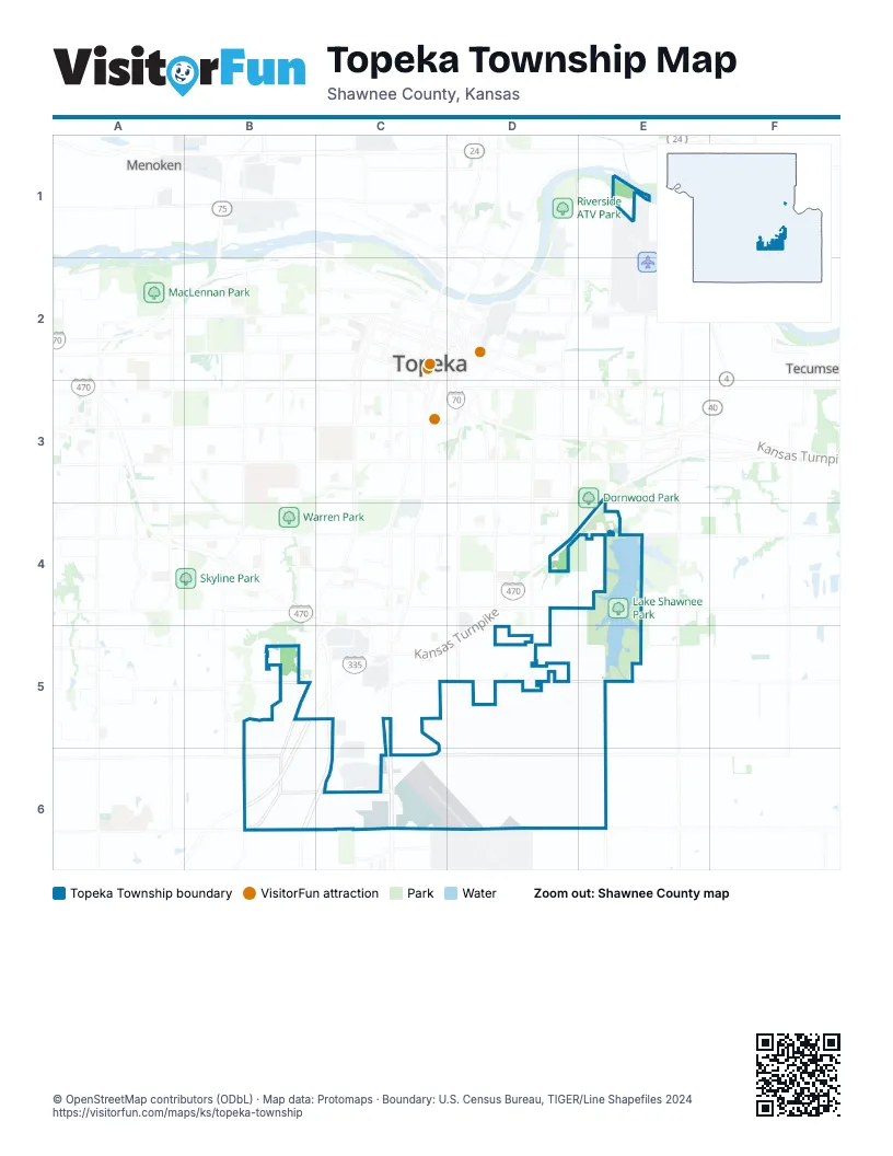
Street index of Topeka Township
Each street on the sheet and the grid squares it crosses.
- Kansas TurnpikeE1, F1, E2, B4, A5, B5, A6
- Southeast Wittenberg RoadF1, F2
- Southeast 29th StreetE2, F2
- Southeast 35th TerraceF2, F3
- Southeast Aquarius DriveF2
- Southeast Dock DriveF2
- Southeast Leisure LaneF2, F3
- Southeast 37th StreetE3, F3
- Southeast 41st StreetE3, F3
- Southeast 43rd StreetE3, E4
- Southeast California AvenueE3, E4, E5, E6
- Southeast Howey RoadE3
- Southeast Ramp RoadE3, F3
- Southeast West Edge RoadE3, F3, F4
- Southeast East Edge RoadF3, F4
- Southeast Memory PointF3
- Southeast Shoreline DriveF3
- Southeast Waters Edge LaneF3
- Southeast Yacht CourtF3
- Southwest 43rd StreetA4
- Southwest 45th StreetA4, B4
- Southwest 46th StreetA4
- Southwest 49th StreetA4, B4
- Southwest Burlingame RoadA4, B4, A5, A6
- Southwest Misty Harbor AvenueA4
- Southwest Misty Harbor DriveA4
- Southeast 45th StreetC4, D4, E4, F4
- Southeast Adams StreetD4, D5, D6
- Southeast Gemstone LaneE4
- Southeast Minnesota AvenueE4
- Southeast Berryton RoadF4, F5, F6
- Southwest 53rd StreetA5
- Southwest 55th StreetA5
- Southwest 57th StreetA5, B5, C5
- Southwest Quail Run CourtA5
- Southwest Quail Run DriveA5
- Southwest Randolph AvenueA5, B5
- Southwest Wenger StreetB5
- Coyote DriveC5, C6
- Flightline RoadC5
- Perimeter RoadC5, D5, D6, E6
- Southeast 53rd StreetC5, D5, E5, F5
- Southeast Coyote DriveC5
- Southeast Elmo DriveC5
- Southeast Lake DriveC5, C6
- Southwest Ash StreetC5
- Southwest Cedar StreetC5, C6
- Southwest Dennis StreetC5
- Southwest Maple StreetC5, C6
- Southwest Mary StreetC5
- Southwest Mike StreetC5
- Southwest Oak StreetC5
- Southwest Pine StreetC5
- Southwest Rex StreetC5
- Southwest Topeka BoulevardC5, C6
- Southeast 55th StreetE5
- Southeast Highland AvenueE5
- Southwest 61st StreetA6
- 9th North StreetC6
- Heritage RoadC6
- Militia RoadC6
- MinutemanC6
- Minuteman RoadC6
- Southeast 59th StreetC6
- Southeast Cross StreetC6
- Southeast Evans StreetC6
- Southeast J StreetC6
- Southwest 58th StreetC6
- Southeast 61st StreetE6
Places on the map
- Amoco
- Baby Dolls
- Banjo's
- Capital City KOA Journey
- East Pauline
- Ferris Wheel Antiques
- Forbes Field
- Herrman's Trailhead
- John's Food Center
- Lake Shawnee
- Lake Shawnee Golf Course
- Lake Shawnee Park
- Lake Shawnee Park Gazebo 1
- Lake Shawnee Park Gazebo 2
- Lake Shawnee Park Shelter 1
- Lake Shawnee Park Shelter 2
- Lake Shawnee Park Shelter 3
- Lake Shawnee Park Shelter 6
- Lake Shawneee Softball Complex
- Landon Nature Trail
- LKQ
- Lynn Creek Cemetery
- Maranatha Baptist Fellowship
- Phillips 66
- SELLERS TRACTOR CO
- Shawnee County Parks Police Department
- Shawnee Lake Off-Leash Dog Area
- Southeast 45th Street
- Super 8 by Wyndham Topeka at Forbes Landing
- Ted Ensley Gardens
- The Garden House
- Tj's Express
- Unique Expressions
Next to Topeka Township
- Highland Park
- Mathews Park
- Terra Heights
© OpenStreetMap contributors, Open Database License, openstreetmap.org/copyright · Map data: Protomaps · Boundary: U.S. Census Bureau, TIGER/Line Shapefiles 2024