

Kansas map
Shawnee County map
About 177,942 people live here (Census Bureau, 2024 estimate). The sheet's index lists 300 streets; Northwest 78th Street, Kansas Turnpike and Truman/Eisenhower Presidential Highway cross the most grid squares. Things to do inside the boundary: Brown v. Board of Education National Historical Park, Combat Air Museum and Kansas Historical Society.
Open the map (PDF, US Letter)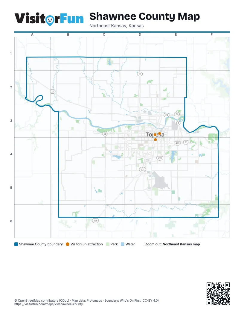
Maps inside Shawnee County
2 maps inside, from the street map of Shawnee County down.
City
Town
Street index of Shawnee County
Each street on the sheet and the grid squares it crosses.
- Kansas TurnpikeD4, E4, F4, C5, D5, C6
- Truman/Eisenhower Presidential HighwayB3, C3, D3, E3, D4, E4
- Dr. Martin Luther King Jr. Memorial HighwayC3, D3, D4
- Oakland ExpresswayE3, E4
- Northwest 24th StreetD3, E3
- Dwight D. Eisenhower HighwayB3, C3
- Addy Westgate Memorial BridgeD3
- Southwest Topeka BoulevardD3, D4, D5, D6
- Northwest Topeka BoulevardE1, E2, D3, E3
- Southwest 6th AvenueC3, D3
- Southwest 10th AvenueC3, D3
- Southeast 6th AvenueD3, E3
- Southeast Madison StreetD3, E3, D4
- Southeast Monroe StreetD3, E3, D4
- Northeast Sherman RoadE1, E2, E3
- Southeast 10th AvenueD3, E3
- Highway 40F4
- South Chestnut StreetC3
- Southeast 6th StreetE3
- West Railroad StreetB3, C3
- West Railroad AvenueC3
- Northwest 46th StreetA2, B2, C2, D2, E2
- Southwest Wanamaker RoadD3, D4, D5, D6
- Southwest 29th StreetB4, C4, D4
- Southeast Croco RoadE3, E4, E5, E6
- Southwest Burlingame RoadD4, D5, D6
- Southwest Auburn RoadC3, C4, C5, C6
- Southwest Indian Hills RoadC3, C4, C5, C6
- Southwest 21st StreetB4, C4, D4
- Southwest Urish RoadC3, C4, C5
- Southeast California AvenueE3, E4, E5, E6
- Southeast 45th StreetD4, E4, F4
- Northwest 35th StreetB3, C3, D3, E3
- Southeast Adams StreetE3, D4, E4, D5, E5, E6
- Southwest 53rd StreetB4, C4, D4, C5
- Southwest 61st StreetB5, C5, D5
- Southeast 29th StreetD4, E4, F4
- Northwest Rochester RoadD1, D2, D3
- Northwest 17th StreetB3, C3, D3
- Southeast 37th StreetD4, E4, F4
- Southwest Davis RoadB4, B5, B6
- Southwest Fairlawn RoadD3, D4, D5
- Southwest Crawford RoadB4, B5, B6
- Southwest Gage BoulevardD3, D4
- Southwest 33rd StreetB4, C4, D4
- Southwest Huntoon StreetC3, D3, C4
- Southwest 37th StreetC4, D4
- Southwest 17th StreetC4, D4
- Southeast Tecumseh RoadE3, E4, E5, E6
- Southeast 21st StreetD4, E4, F4
- Southwest 57th StreetB5, D5
- North Kansas AvenueE2, D3, E3
- South Kansas AvenueD3, D4
- Southwest 45th StreetC4, D4
- Southwest 41st StreetB4, C4, D4
- Southwest Macvicar AvenueD3, D4
- Southwest 12th StreetC3, D3, D4
- Northeast 46th StreetE2
- Northeast Croco RoadE2, E3
- Northeast Seward AvenueE3
- Southwest 8th AvenueD3
- Southwest Douglas RoadB4, B5
- Southeast 10th StreetE4, F4
- Southwest Washburn AvenueD3, D4
- Southwest Lane StreetD3, D4
- Northeast Sardou AvenueE3
- Southwest Harrison StreetD3, D4
- Southwest Seabrook AvenueD3, D4
- Northwest Tyler StreetD3
- Northeast Quincy StreetE3
- Northwest Gordon StreetD3, E3
- Northeast Strait AvenueE3
- Southwest 42nd StreetD4
- Southwest Jackson StreetD3, D4
- Southwest Nottingham RoadC4
- Southeast Branner StreetE3, E4
- Northwest Vail AvenueD2, D3
- Southeast 8th AvenueD3, E3
- Northwest Morse StreetD3, E3
- Southeast Branner TrafficwayE3, E4
- Northwest MacVicar AvenueD3
- Northeast Gordon StreetE3
- Southwest Glitch RoadB4
- North 1700 RoadF4
- Northeast Branner StreetE3
- Northeast Morse StreetE3
- Northwest 86th StreetA1, B1, C1, D1, E1
- Northwest 62nd StreetA2, B2, C2, D2, E2
- Northwest 78th StreetA1, B1, C1, D1, A2, B2, C2, D2
- Southwest Hoch RoadC3, C4, C5, C6
- Northwest Humphrey RoadC1, C2, C3
- Southeast Paulen RoadE4, E5, E6
- Northwest 70th StreetA2, B2, C2, D2
- Southeast 53rd StreetD4, E4, F4
- Southeast Stubbs RoadF4, F5, F6
- Northwest 94th StreetA1, B1, C1, D1, E1
- Northwest Valencia RoadC1, B2, C2, B3
- Northwest Docking RoadB1, B2, B3
- Southeast 2nd StreetE3, F3
- Southeast Ratner RoadE4, E5, E6
- Northwest Hoch RoadC1, C2, C3
- Northwest Carlson RoadB1, B2, B3
- Southwest Carlson RoadB3, B4, B5, B6
- Southeast Shawnee Heights RoadF3, F4, F5, F6
- Southeast Berryton RoadE4, E5, E6
- Southwest 77th StreetB5, C5, D5
- Southeast 61st StreetE5, F5
- Northwest Landon RoadC1, C2, C3
- Northwest 25th StreetB3, C3, D3
- Southwest 89th StreetB5, C5, D5
- Northeast Meriden RoadE2, E3
- Southeast 77th StreetD5, E5, F5
- Southwest 93rd StreetD5, C6
- Southwest Valencia RoadB3, B4, B5, B6
- Southwest 13th StreetB3, D3, D4
- Northwest 13th StreetB3, C3
- Northwest Huxman RoadC2, C3
- Southeast Shadden RoadF3, F4, F5, F6
- Southeast 89th StreetE5, F5
- Northwest Brickyard RoadD2, D3
- Southeast 93rd StreetD5, E5
- Southwest 10th StreetC3
- Northwest Green Hills RoadD1, D2, D3
- Southwest Glick RoadB3, B4, B5, B6
- Southwest Randolph AvenueD3, D4, D5
- Northwest 66th StreetC2, D2, E2
- Southwest 27th StreetC4, D4
- Northeast 82nd StreetE1
- Northwest Rossville RoadB2
- Southwest 25th StreetC4, D4
- Southeast 105th StreetE6, F6
- Northwest Menoken RoadD2, D3
- Southwest Belle AvenueD3, D4
- Northeast 62nd StreetE2
- Northeast 35th StreetE3
- Southeast 25th StreetD4, E4
- Northwest Capper RoadB1, B2
- Southwest Oakley AvenueD3, D4
- Southwest West Union RoadB3, B4
- Southeast Indiana AvenueE3, E4
- Northwest Frontage RoadD3
- Southwest Clay StreetD3, D4
- Northwest Maple Hill RoadA2
- Southwest Westport DriveD4, D5
- Southwest Western AvenueD3, D4
- Northwest 50th StreetB2, D2, E2
- Southeast West Edge RoadE4
- Northeast 39th StreetE2
- Southeast Golden AvenueE3, E4
- Southeast Jefferson StreetD3, E3, D4
- Southeast 4th StreetD3, E3
- Northeast 70th StreetE2
- Southwest Arrowhead RoadD3, D4
- Northeast Silver RoadE1, E2
- Southwest 34th StreetD4
- Northeast 74th StreetE2
- Southwest 9th StreetD3
- Southwest Shunga DriveD4
- Southeast Quincy StreetD3, E3, D4
- Southeast 23rd StreetD4, E4
- Southeast Rice RoadE3, E4
- Northwest Lyman RoadD3, E3
- Southwest Arvonia PlaceD3, C4, D4
- Southwest 1st StreetD3
- Northwest 82nd StreetB1, D1, E1
- Northwest West Union RoadB3
- Southeast 34th StreetD4, E4
- Southeast Highland AvenueE3, E4, E5
- Northeast Calhoun Bluff RoadE3
- Southwest Twilight DriveD4
- Southwest 4th StreetD3
- Northwest Taylor StreetD2, D3
- Southeast 5th StreetD3, E3
- Southeast Deer Creek TrafficwayE3, E4
- Southwest 14th StreetD4
- Southwest Innovation ParkwayD5
- Northwest Menninger RoadD3, E3
- Southeast Fremont StreetD4
- Northeast Chester AvenueE3
- Southeast Wisconsin AvenueE4
- Northwest Oldham RoadA2
- Southwest 5th StreetD3
- Southwest 32nd StreetC4, D4
- Southwest Burch RoadD4, D5
- Southwest 38th StreetD4
- Southeast Lakeshore BoulevardE4
- Southwest 32nd TerraceD4
- Southeast Carnahan AvenueE3, E4
- Southeast Gary Ormsby DriveD5, E5
- Southwest Gary Ormsby DriveD5
- Southwest Arnold AvenueD4
- Northeast Jefferson StreetE3
- Southwest Kingsrow RoadC4
- Southwest 39th StreetD4
- Northwest Lower Silver Lake RoadD3
- Southeast 1st StreetD3, E3
- Southwest Westchester RoadD3
- Northwest 42nd TerraceB2, D2
- Southeast 15th StreetD4, E4
- Southeast Washington StreetE4
- Northeast Division StreetE3
- Southeast 9th StreetD3, E3, E4
- Main StreetB2
- Southwest Croix StreetD4
- Northwest Stover RoadD3
- Southeast 17th StreetD4, E4
- Southwest Westview AvenueD4
- Coyote DriveD5
- Northeast Freeman AvenueE3
- Southwest Willow AvenueD3
- Southwest Patton RoadC3
- Southwest Westview RoadD5
- Northeast River RoadE3
- South Vauter RoadD6
- Wabaunsee StreetB3
- Southwest 47th StreetD4
- Southwest Roosevelt StreetD3
- Southeast Cyprus DriveE4
- Southwest University BoulevardD5
- Northwest Tibbs RoadC2
- Northeast Goodell RoadE3
- Washington StreetC5
- Southeast University BoulevardD5
- Southwest Summit AvenueD3
- Southwest Greenwood AvenueD3
- Northwest E RoadB1
- South Rice RoadC3
- Southwest Woodlawn AvenueD3
- Southeast Sycamore DriveE4
- North Washington StreetC5, C6
- East Lake StreetC3
- Northeast 94th StreetE1
- Southeast Evans StreetD5
- Southwest Clontarf StreetD4
- Northeast Rice RoadE3
- Northeast Golden AvenueE3
- Southwest Martin DriveD4
- Northwest Goodyear RoadD3
- West 8th StreetC5
- South Fairlawn RoadD6
- East 1st StreetC6
- South Auburn RoadC6
- Minuteman RoadD5
- Southeast Coyote DriveD5
- Southwest Southgate DriveD4
- Militia RoadD5
- Northwest Beverly StreetD3
- Northeast Jefferson TrafficwayE3
- South Shawnee Heights RoadF6
- North 1150 RoadF5
- Southwest Quinton AvenueD3
- Rice Road, I 170, Cypress Road RoundaboutE4
- Rice Road, I 170, Sycamore Road RoundaboutE4
- 75th StreetE2
- K RoadC1
- Heritage RoadD5
- MinutemanD5
- Northwest 54th StreetA2, B2, C2, D2
- Southwest 69th StreetB5, C5, D5
- Northwest Davis RoadB1, B2, B3
- Southeast 101st StreetD6, E6, F6
- Southwest Hodges RoadC3, C4, C5, C6
- Southeast Stanley RoadF4, F5
- Northwest 39th StreetB2, C2, D2, E2
- Southeast 69th StreetE5, F5
- Northwest Hodges RoadC1, C2, C3
- Southwest 85th StreetC5, D5
- Northwest Bailey RoadA1, A2
- Southwest 101st StreetB6, C6, D6
- Southeast 85th StreetD5, E5, F5
- Southwest Docking RoadB3, B4, B5
- Perimeter RoadD5, E5
- Northeast Indian Creek RoadE1, E2
- Southwest 49th StreetB4, C4, D4
- Northwest Jennings RoadD1, D2
- Southwest 109th StreetB6, C6, D6
- Northeast Kincaid RoadE2, E3
- Northwest Crawford RoadB1, B2, B3
- Northwest Button RoadD2, D3
- Northwest Hall RoadA1, A2
- Southeast Woodring Road - East 1 RoadF3, F4, F5, F6
- Northwest Leedy RoadD2, D3
- Southeast Green RoadF3, F4, F5, F6
- Northwest Anthony RoadA1, A2
- Southwest 103rd StreetC6, D6
- Northwest Arn RoadA1, A2
- Northwest 21st StreetB3, C3
- Southwest 97th StreetB6, C6, D6
- Southwest 19th StreetC4, D4
- Southwest 23rd StreetC4, D4
- Northwest Goodyear Plant RoadD3
- Southeast 109th StreetE6, F6
- Southwest Jewell AvenueD3, D4
- Northwest 33rd StreetB3, D3
- Southwest Moundview DriveD4, D5
- Southwest 15th StreetD4
- Southwest Jordan RoadD5, D6
- Southwest 24th StreetC4, D4
- Southeast Mtaa-ForbesD5, E5
- Northwest 74th StreetB2, C2, D2, E2
Things to do on the Shawnee County map
Places on the map
- Auburn
- Bauersfelds Market
- Berkshire Country Club
- Bettis Family Sports Complex
- Big Shunga Park
- Big Springs (#350)
- Capital City KOA Journey
- Clarion Woods Park
- Colmery-O'Neil VA Medical Center
- Crestview Park
- Cypress Ridge Golf Course
- Dornwood Park
- Fairlawn Plaza
- Felker Park
- Forbes Industrial Park Warehousing
- Forbes Public Golf Course
- Grant Bradbury Park
- Green Wildlife Area
- Hayden Catholic High School
- Heartland Park
- Hillcrest Park
- Hummer Sports Park
- Iliff Commons
- Lake Jivaro
- Lake Shawnee
- Lake Shawnee Golf Course
- Lake Shawnee Park
- MacLennan Park
- Philip Billard Municipal Airport
- Riverside ATV Park
- Rolling Meadows Landfill
- Rossville
- Rossville Township
- Shawnee State Fishing Lake
- Sherwood Lake
- Silver Lake
- Skyline Park
- Topeka
- Warren Park
- West Ridge Mall
© OpenStreetMap contributors, Open Database License, openstreetmap.org/copyright · Map data: Protomaps · Boundary: Who's On First (CC-BY 4.0); Quattroshapes (CC BY 2.0)